| Pages:
1
2
3
4
5
..
7 |
wessongroup
Platinum Nomad

Posts: 21152
Registered: 8-9-2009
Location: Mission Viejo
Member Is Offline
Mood: Suicide Hot line ... please hold
|
|
This may help ... 
|
|
|
David K
Honored Nomad
Posts: 65563
Registered: 8-30-2002
Location: San Diego County
Member Is Offline
Mood: Have Baja Fever
|
|
Hilarious! Thank you... I will use that in the future! LOL
|
|
|
wessongroup
Platinum Nomad
Posts: 21152
Registered: 8-9-2009
Location: Mission Viejo
Member Is Offline
Mood: Suicide Hot line ... please hold
|
|
Good to see something which isn't argued about ... 
and under the description ..
"I am told this video is still utilized as a training aid for prospective politicians, lawyers, and spin doctors."
|
|
|
PaulW
Ultra Nomad
Posts: 3113
Registered: 5-21-2013
Member Is Offline
|
|
Where is Widowmaker. I never heard that name till I joined Nomads?
|
|
|
David K
Honored Nomad
Posts: 65563
Registered: 8-30-2002
Location: San Diego County
Member Is Offline
Mood: Have Baja Fever
|
|
If you search Widowmaker on You Tube, you will see it has been a popular name for the extreme steep/ rocky grade, just over 1 mile west of Mission
Santa Maria. You must drop down it going to the mission, only to have to climb it to return to Rancho Santa Ynez/ Cataviña.
My first time over it was on a quad in 1999, with the late Baja Mur who was on a motorcycle. Climbing back up, we were both thrown from our rides and
left blood on the rocks... that's when I named it The Widowmaker!
Old time off road desert rat and Aridologist, Neal Johns advised me after that trip to get a Toyota Tacoma Off Road 4WD truck as it came from the
factory with a locking differential. It was Neal's opinion that the locker would be needed to climb up the Widowmaker. I seriously wanted to return to
Mission Santa Maria, after the brief visit in '99.
I have taken all three of my Tacomas to the mission as an initiation to prove my truck worthy to be called 'Baja Proven'! Other Nomads have joined me
on those three trips. Neal Johns was on the last one, and it was he who needed to be pulled back to civilization when his custom locking differential
shattered soon after leaving the mission. Neal was 80 years old and he was tough as the desert being pulled out of the deep canyon the mission is
located in.
Ken Cooke calls it Mission Impossible (from a Baja guidebook description of the road) in his posts. It is a road much like the Rubicon Trail in that
you drive on granite boulder. It takes close to three hours to drive the 14.5 miles!
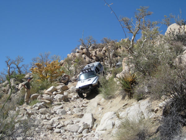
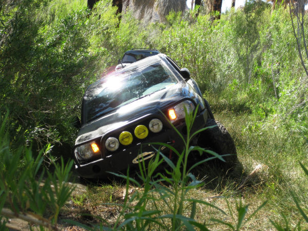
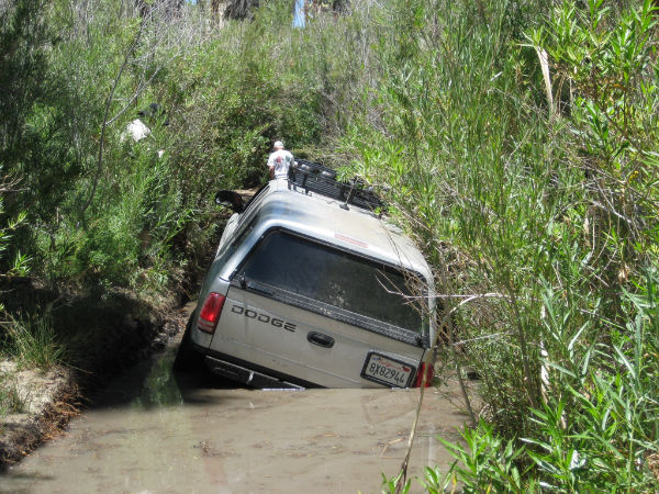
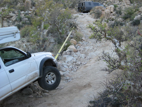
Photos from my 4 trips to Mission Santa Maria:
1999 (my first web page, made in 2000, where I call it Widowmaker): http://www.vivabaja.com/missionsm/index.html (1 bike, 1 quad)
2003: http://www.vivabaja.com/403/ (2 Toyotas, 1 Jeep, Lost Dog, Rattlesnake)
2007: http://vivabaja.com/msm/ (1 Toyota, 1 Land Rover, Bighorn Sheep)
2010: http://vivabaja.com/msm2010/ (4 Toyotas, 1 Dodge, 1 4WD Motorhome)
Nomads in Low Range having fun!...

WIDOWMAKER DOWN:

THE BOG:
MISSION COMPLEX 1767-1774:

More steep grades beyond the mission to the end of the road...

Back into the BOG!

WIDOWMAKER UP:

That was a long night! All ended up well thanks to good Nomad friends, and great azzistance from Baja Cactus to get Neal running again!
[Edited on 12-3-2014 by David K]
|
|
|
David K
Honored Nomad
Posts: 65563
Registered: 8-30-2002
Location: San Diego County
Member Is Offline
Mood: Have Baja Fever
|
|
I solved the burro auto correct by using z's in azzistance so it doesn't read assistance! LOL
|
|
|
PaulW
Ultra Nomad
Posts: 3113
Registered: 5-21-2013
Member Is Offline
|
|
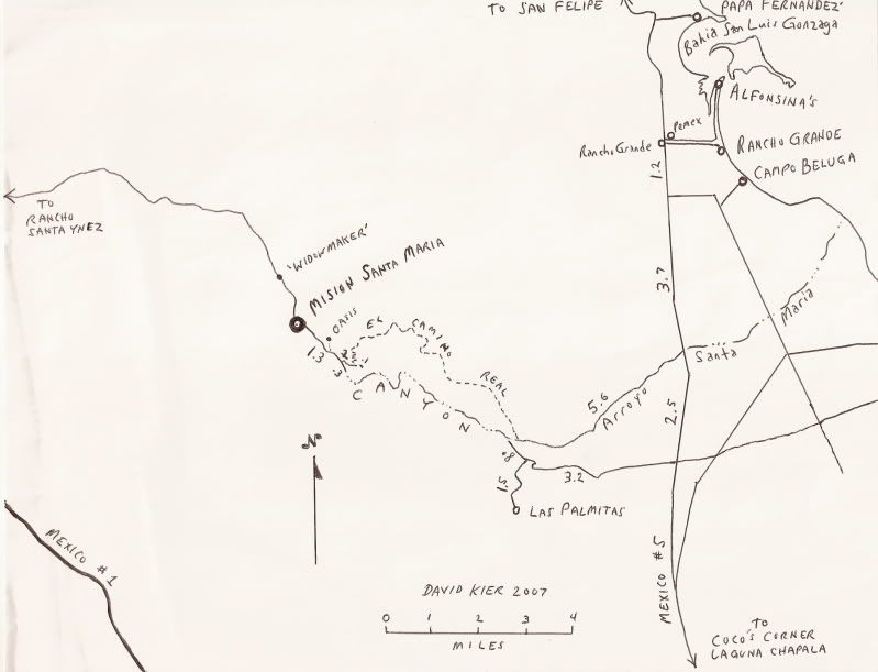
DK, Thanks for the Widowmaker input. I had discovered your hand drawn 2007 map a while back, but was confused as usual. So after the mission what is
the road like to get to Gonzaga?
I originally had it in my mind that Widow maker was the bad hill between La Turqueasa and Hwy 1 ? Your map set me straight.
Thanks
|
|
|
David K
Honored Nomad
Posts: 65563
Registered: 8-30-2002
Location: San Diego County
Member Is Offline
Mood: Have Baja Fever
|
|
Quote: Originally posted by PaulW  | DK, Thanks for the Widowmaker input. I had discovered your hand drawn 2007 map a while back, but was confused as usual. So after the mission what is
the road like to get to Gonzaga?
I originally had it in my mind that Widow maker was the bad hill between La Turqueasa and Hwy 1 ? Your map set me straight.
Thanks |
Hi Paul. There is NO auto road to Gonzaga from the mission! There is only EL CAMINO REAL beyond the bulldozed roadbed from the early 1970's when
construction to Punta Final was abandoned, 2 miles east of the mission.
The Fred Hampe road reached the edge of the deep Santa Maria Canyon and he either gave up, or the Highway was being built and that would speed up the
drive between Santa Ynez and Punta Final (both owned by the same lady, Josefina Zuñiga).
The Franciscan constructed Camino Real goes from near the end of the Hampe road, up the north ridge of the canyon and stays along the north ridge to
where the canyon ends on the desert near Gonzaga. The Jesuits had used an Indian trail in the canyon bottom to where it climbed up and hits the end of
the Hampe Road (you can see all this on Google Earth). The Jesuit route was dangerous to travel over. They were removed from California only 7 months
after moving to Santa Maria from Calamajué, so not enough time for them to have a better road made.
At that point, the Camino Real went to Las Palmitas oasis then east and south to Calamajué and San Borja, passing just west of Coco's Corner.
A couple of motorcycles with damage have used the Camino Real to go from Gonzaga to the mission, but it is seriously a hiking trail only. Even Graham
Mackintosh tried to get his burro to Gonzaga on it, and it was a disaster.
Another trail was built by the Franciscans to supply Serra's first missions (San Fernando and then San Diego) and it goes just north of the Santa
Maria mission and goes to the bay near Papa Fernandez where a warehouse was built. Baja Bucko and her son road mules on it back in 2001 and even hid a
geocache along the way! You can see some of this cargo trail on GE as well.
The closest auto road from Gonzaga to Cataviña is the LA TURQUESA CANYON trail, known to some as Coco's Shortcut or the XR RIDE. Made passable with
hand labor by The squarecircle, TW, and others... then Roy (The squarecircle) drove his LR3 Land Rover up it and to Hwy. 1 from Hwy. 5).
Here's that 2007 map I made, for anyone who is curious...
[Edited on 12-4-2014 by David K]
|
|
|
chippy
Super Nomad
Posts: 1806
Registered: 2-2-2010
Member Is Offline
|
|
The "bog" looks harder then the rocky hills? I wouldn´t think a rear locker would make any difference in that mud? Great going!
|
|
|
David K
Honored Nomad
Posts: 65563
Registered: 8-30-2002
Location: San Diego County
Member Is Offline
Mood: Have Baja Fever
|
|
The bog that wet year (2010) was indeed scarier than the Widowmaker!
It had never been that deep and one year it was just wet sand.
I never used my locker in 2010, but instead used the A-TRAC, and that was better as it auto-locks the front tires too. In the bog and all of the hill
climbing was in Low Range, A-TRAC... and no problem getting through, but it was tense! HB Murphy's lady recorded that trip and it's on You Tube. She
screams as their Tacoma splashes in the deep water! Very funny listening to her concern over us, we were behind them.
|
|
|
willardguy
Elite Nomad
Posts: 6451
Registered: 9-19-2009
Member Is Offline
|
|
I thought there was a nomad that made Gbay to the mission in a jeep, no? malcolm's boy did it, the kid next door and his pop made it (in rokon's).
good tune up for erzberg eh?
|
|
|
David K
Honored Nomad
Posts: 65563
Registered: 8-30-2002
Location: San Diego County
Member Is Offline
Mood: Have Baja Fever
|
|
It is physically impossible due to cliffs, boulders, and you are the side of a mountain with a 1,000 ft. drop in parts!
Yes, a Rokon would be possible with great care. Kevin Ward (Dust to Glory producer, Baja 1000 racer) did it on a Honda XR with great damage to it when
he had to launch it across ravines by popping the clutch and picking it up on the other side! Malcolm Smith has gotten credit as well for many crazy
routes in Baja!
My son and I hiked 2/3 of the way in 2003: http://vivabaja.com/1103/page2.html
[Edited on 12-4-2014 by David K]
|
|
|
willardguy
Elite Nomad
Posts: 6451
Registered: 9-19-2009
Member Is Offline
|
|
soooo... supplies dropped off at the west end of bahia willard destined for santa maria mission took this route????

|
|
|
David K
Honored Nomad
Posts: 65563
Registered: 8-30-2002
Location: San Diego County
Member Is Offline
Mood: Have Baja Fever
|
|
The missionary explorer Consag named the sheltered bay San Luis Gonzaga. The point by Papa Fernandez' that encloses the north end of the bay was named
'Willard' a hundred and fifty years later, then the U.S. mapped the coast of Baja and applied Willard to the bay already named Gonzaga. It's been
confusing ever since, LOL!
Your photo location isn't given, but if that's Santa Maria Canyon, then NO.
Supplies for San Fernando mission and those beyond were dropped off on the west side of Gonzaga Bay, where the warehouse ruins are. The trail went
west in Arroyo Alfredo or parallel to it before climbing the hills. You can see it on satellite images before it intersects with the Mission Santa
Maria road, about 3-4 miles west of that mission.
Once Mission San Fernando de Velicatá was founded in 1769, Mission Santa Maria was not a full mission for long before becoming just a way-station on
the Camino Real. The last documents of it as a mission were in 1774.
Here is the Camino Real route in the region, as well as the missions...
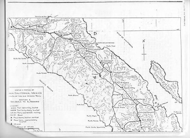
Howard Gulick Map 1955
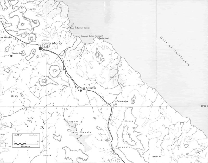
Harry Crosby Map 1977
|
|
|
PaulW
Ultra Nomad
Posts: 3113
Registered: 5-21-2013
Member Is Offline
|
|
========
on http://vivabaja.com/1103/page4.html on your GPS directions you make a note "(ECR-x)" what is that a shortcut for?
Just a WP name?
PW
|
|
|
David K
Honored Nomad
Posts: 65563
Registered: 8-30-2002
Location: San Diego County
Member Is Offline
Mood: Have Baja Fever
|
|
Hi Paul,
I posted those 2003 GPS notes here for clarification. I don't have an 'ECR-x', unless you mean any or all of them (1-8)? None are short cuts, but the
actual GPS on EL CAMINO REAL (at map datum NAD27 Mex). I have newer postings. Also note that the Las Palmitas access road was reported washed out
where it drops down about 3 miles from Hwy. 5. Using the arroyo from the new bridge may be the only way now?
GPS Directions (map datum NAD27 Mexico)
Take Hwy. 5 south 7.4 miles from Rancho Grande, turn west: 29°41.094'/ 114°24.566'
3.2 miles west of Hwy. 5, go straight where most traffic curves left for Las Palmitas: 29°41.278'/ 114°27.639'
0.8 miles from above, park at huge boulder: 29°41.68'/ 114°28.20'
Hike to north bank of Arroyo Santa Maria to: 29°41.733'/ 114°28.175' elev. 609' (ECR-1)
Go northwest and climb out of valley, note ocotillos.
Along left side of side valley: 29°42.374'/ 114°28.566' elev. 741' (ECR-2)
On first padre built switchback up: 29°42.669'/ 114°28.937' elev. 906' (ECR-3)
On a ridge, trail continues northwest: 29°42.671'/ 114°29.425' elev. 1308' (ECR-4)
On the Camino Real: 29°42.748'/ 114°29.482' elev. 1391' (ECR-5)
Crossing ridges and little mesas: 29°43.008'/ 114°29.967' elev. 1477' (ECR-6)
Drop along side of ridge, trail narrow: 29°43.074'/ 114°30.128' elev.1610' (ECR-7)
End of today's hike just beyond this last clear sign of the old trail: 29°43.141'/ 114°30.189' elev. 1702' (ECR-8)
Junction of ECR & bulldozed road: 29°43.126'/ 114°31.753' elev.1413'
(End of bulldozed road, on canyon ridge: 29°43.033'/ 114°31.556' elev. 1,615' )
Mision Santa Maria: 29°43.891'/ 114°32.794' elev.1628'
--------------------------------------------------------------------------------------
Here's my Mission Santa Maria road log from 2007, and note Mile 15.9 is where the Camino Real meets the road, which is the "Junction of ECR &
bulldozed road" waypoint above:
ROAD LOG
0.0 Rancho Santa Ynez, take road through left gate, north of ranch.
0.9 FORK, go left/ uphill.
1.8 Deep Gully, 4WD climb out (if this scares you, go back!).
2.4 Rock pile, a road to left, go straight/ right fork.
4.7 Cement monument off to left (tracks continue past monument).
5.6 Arroyo crossing with palms.
9.9 Peninsular Divide, view of Punta Final on the gulf.
13.3 Top of the 'Widowmaker' grade.
14.4 MISION SANTA MARIA
15.4 Road enters sandy Arroyo Santa Maria, after very steep downgrade.
15.7 Turn left, out of arroyo (may be hidden by plants). Tracks ahead in arroyo end in 1/4 mile.
15.9 El Camino Real climbs to the left, up hillside. The mission trail stays out of the canyon, along the north ridge and returns to the arroyo at the
east end of the canyon.
16.0 Roadbed washed out. Park and hike on to end of bulldozed grade to see petroglyphs, canyon view, Indian trail to canyon bottom.
Here is what you see at Mile 15.9 looking at the trail from the road:
El Camino Real at 29°43.126', 114°31.753' (NAD27 Mex) elev. 1,413'
NOTE: In 2010, the road was impassable about Mile 15.5 to our Toyotas due to exposed boulders (it was all sand here in 2007), so a hike to El Camino
Real at the road was required.
|
|
|
David K
Honored Nomad
Posts: 65563
Registered: 8-30-2002
Location: San Diego County
Member Is Offline
Mood: Have Baja Fever
|
|
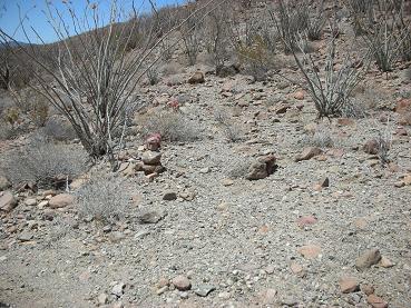
CARGO TRAIL from Santa Maria Road
I have two photos taken where you can see the Cargo Trail from the road to the mission (which is essentially on El Camino Real)... Photos looking
northward as we are driving east, about a mile east of the high point on the road (peninsular divide, which is 9.9 miles from Santa Ynez, 4.5 from the
mission)...

Look for a straight line going across the photo, left to right, about midway up the photo.
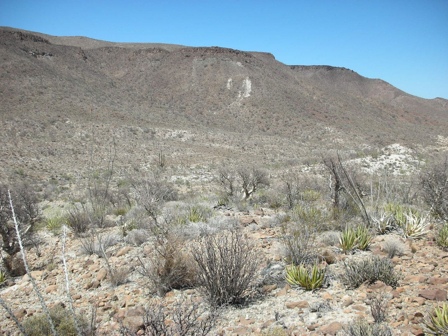
About the same, but climbing a bit to the right side. See the three armed cardon cactus in the distance? The trail is just behind it, near the top of
it. just past the cardon, it drops down a bit, then climbs gradually as it heads towards Gonzaga Bay.
The Geocache placed on the Cargo Trail, or near it, in 2001 by Baja Bucko: http://www.geocaching.com/geocache/GC8C7_no-wheels-need-appl...
[Edited on 12-4-2014 by David K]
|
|
|
TMW
Select Nomad
Posts: 10659
Registered: 9-1-2003
Location: Bakersfield, CA
Member Is Offline
|
|
["DK wrote: Also note that the Las Palmitas access road was reported washed out where it drops down about 3 miles from Hwy. 5. Using the arroyo from
the new bridge may be the only way now?"]
The normal road down to the arroyo is washed out with very deep ruts where a 4 wheeler can't use it. However there is another road down just to east.
It is deep sand so a regular truck or SUV can't make it back up. A motorcycle, ATV or sand rail could. In April we had to follow the arroyo east to
the hwy 5 construction area and find a place to get up on hwy 5.
|
|
|
David K
Honored Nomad
Posts: 65563
Registered: 8-30-2002
Location: San Diego County
Member Is Offline
Mood: Have Baja Fever
|
|
Thanks for that confirm TW. It is a wild piece of Baja, even though a paved highway is only a few miles away now!
|
|
|
willardguy
Elite Nomad
Posts: 6451
Registered: 9-19-2009
Member Is Offline
|
|
problem is, as of last week the whole area is fenced off with 4 strand barbed wire. if you want in don't forget the side cutters!
yup, its the new baja. 
|
|
|
| Pages:
1
2
3
4
5
..
7 |


