| Pages:
1
2
3 |
Enrique2012
Nomad
 
Posts: 105
Registered: 4-19-2012
Member Is Offline
|
|
Very nice to see you back down south again. Hope one day to run into you down there.
Thanks for a great report David. Much appreciated!
Loreto - San Juanico - Huntington Beach
[Edited on 7-16-2016 by Enrique2012]
|
|
|
David K
Honored Nomad
        
Posts: 65445
Registered: 8-30-2002
Location: San Diego County
Member Is Offline
Mood: Have Baja Fever
|
|
De nada Enrique. Donde vives tu?
|
|
|
David K
Honored Nomad
        
Posts: 65445
Registered: 8-30-2002
Location: San Diego County
Member Is Offline
Mood: Have Baja Fever
|
|
Quote: Originally posted by JohnK  | | I really like the way you lay it out, David. Great post. I've got a pop-up camper on the back of my Tacoma. Do you think I would be OK going to Shell
Island with it? Good tires. 4WD. |
Yes, weight is not an issue with deflated tires. 10-20 psi range. Start at 20, if the truck struggles or wants to dig into the sand, do not spin the
tires, just stop and let out more air. You will find the "sweet spot" and float.
I knew a family from Vista, CA who drove full-sized motorhomes onto the beach at Shell Island... 2WD motorhomes... and no problem using the largest
tires that would fit and deflating. I ran into them at Sunrise Cafe in Vista a couple years back (Bob and Pat Hale) and it was fun talking about their
days camping on the island since the 70s. Before the new highway was built in '82, an arroyo was used to reach the island from 5 miles west where the
old Puertecitos road was.
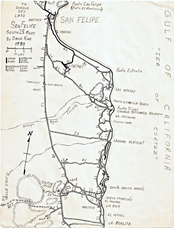
Here is my map from 1980:
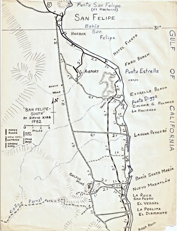
Here is the map I drew 2 years later with the new highway (unpaved):
|
|
|
JohnK
Junior Nomad

Posts: 69
Registered: 3-11-2012
Member Is Offline
|
|
David, thank you. I'm putting your maps on my IPad and IPhone...
|
|
|
David K
Honored Nomad
        
Posts: 65445
Registered: 8-30-2002
Location: San Diego County
Member Is Offline
Mood: Have Baja Fever
|
|
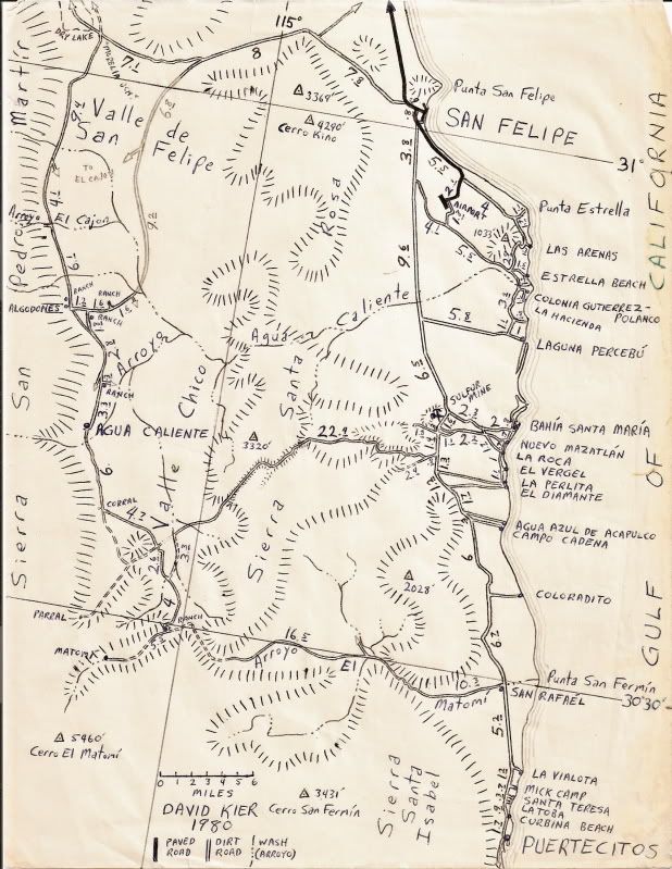
LOL... thanks, but those are ancient now! Most of the dirt roads are still there, however!
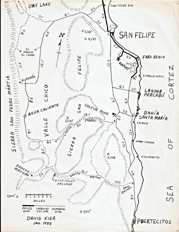
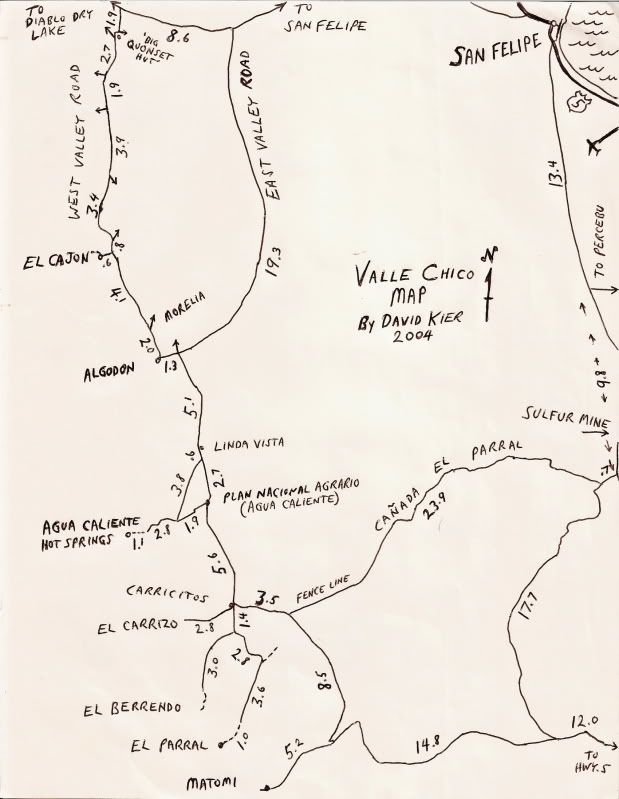
Here are a few more I drew of the region...
|
|
|
steekers
Nomad
 
Posts: 257
Registered: 12-4-2007
Member Is Offline
|
|
Awesome post David. I wish I could have joined you for the day at Shell Island while we were down at EDR. Will have to have a coffee in SM when we are
in the area. Thanks for the great photos.
|
|
|
David K
Honored Nomad
        
Posts: 65445
Registered: 8-30-2002
Location: San Diego County
Member Is Offline
Mood: Have Baja Fever
|
|
Quote: Originally posted by steekers  | | Awesome post David. I wish I could have joined you for the day at Shell Island while we were down at EDR. Will have to have a coffee in SM when we are
in the area. Thanks for the great photos. |
De nada Michael!
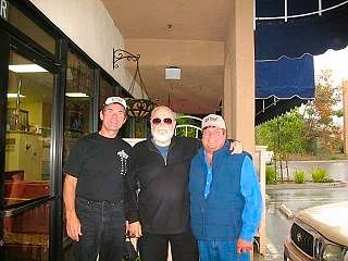
Here's a photo of "steekers" (tall guy) when I introduced him to Baja racing and cartoon legend, Dave Deal (with beard) a few years ago in Vista, CA
(Sunrise Cafe).
|
|
|
Barry A.
Select Nomad
      
Posts: 10007
Registered: 11-30-2003
Location: Redding, Northern CA
Member Is Offline
Mood: optimistic
|
|
David--------On your hand-drawn map which is the last map shown above, you show the 17+ mile drive from the Sulfur Mine to Matomi wash------has
anybody driven that stretch recently and if so is it a rewarding and scenic drive? (It is the ONLY road on your map that I have never driven over.)
|
|
|
David K
Honored Nomad
        
Posts: 65445
Registered: 8-30-2002
Location: San Diego County
Member Is Offline
Mood: Have Baja Fever
|
|
Quote: Originally posted by Barry A.  | | David--------On your hand-drawn map which is the last map shown above, you show the 17+ mile drive from the Sulfur Mine to Matomi wash------has
anybody driven that stretch recently and if so is it a rewarding and scenic drive? (It is the ONLY road on your map that I have never driven over.)
|
Hi Barry, great question!
I got interested in that road because Howard Gulick thought enough of it to include it, but never mentioned it in his Lower California Guidebook...
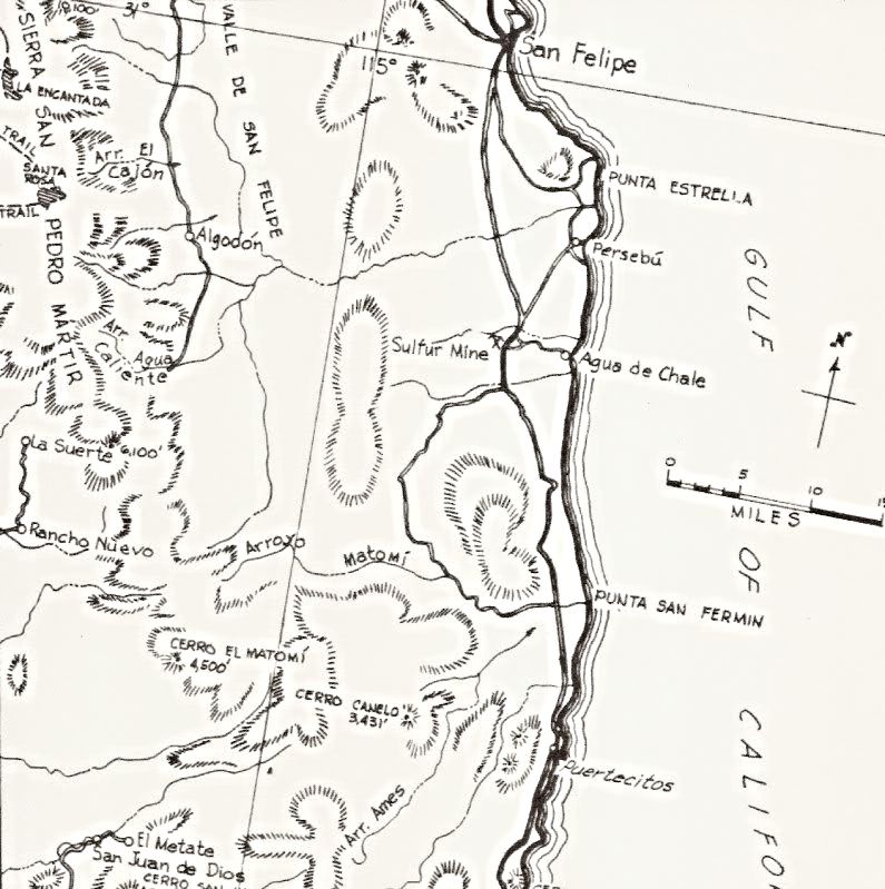
1962 Edition Lower California Guidebook
I call it the Llanos San Fermin road, after the name of that valley (or plain).
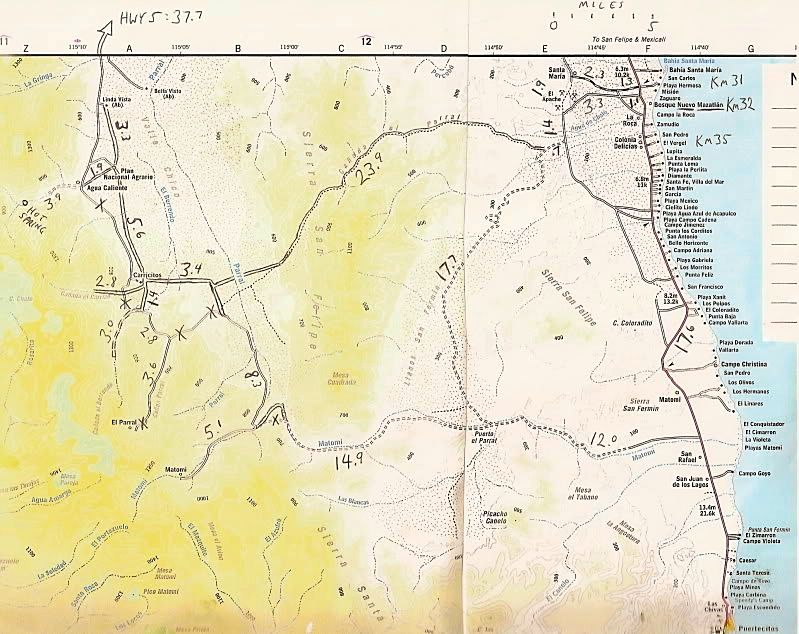
I have driven over it once... was traveling along with Nomad Gila Oro (Max) and his wife who both were in a Suzuki... May 2003:
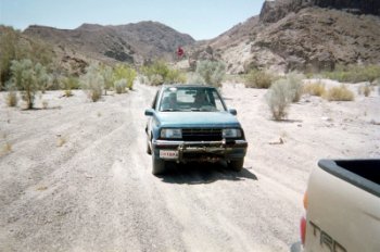
Max follows me up Arroyo Matomi...
The Geo Tracker does fine.
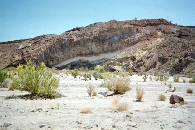
Looking like layers in a cake, Matomi has many interesting geologic features!
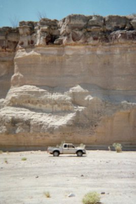
The lower Matomi canyon.... just one of so many great places to explore in Baja!

Our lunch break in the middle of the Llanos (Plains) of San Fermin.
Just minutes after this photo was taken, a dust devil hit us, lifted my chair (in photo)
and set it down (to the left of the picture) on top of Max's hat!
GPS here: 30°34.23'/ 114°52.23' (NAD27), elev. 1,144'.
That's all I have but I do remember the road passed a capped wellhead and there was quite a cluster of bees on it. Apparently, they got plenty of
water crawling through a gap in the cap. It was a pretty slow road, as SCORE has used it a few times for the San Felipe 250 and that seems to create
whoop-d-do's.
[Edited on 5-23-2020 by David K]
|
|
|
honda tom
Nomad
 
Posts: 493
Registered: 8-28-2003
Location: middle calif
Member Is Offline
|
|
Quote: Originally posted by Barry A.  | | David--------On your hand-drawn map which is the last map shown above, you show the 17+ mile drive from the Sulfur Mine to Matomi wash------has
anybody driven that stretch recently and if so is it a rewarding and scenic drive? (It is the ONLY road on your map that I have never driven over.)
|
I drove it in march. first half was a little slow.. rocky .......the middle was faster with medium size whoops..... the last was fast and fun. less
than an hour to matomi. did not use 4 wheel drive.
|
|
|
Barry A.
Select Nomad
      
Posts: 10007
Registered: 11-30-2003
Location: Redding, Northern CA
Member Is Offline
Mood: optimistic
|
|
Thanks, guys, I appreciate the info.
|
|
|
David K
Honored Nomad
        
Posts: 65445
Registered: 8-30-2002
Location: San Diego County
Member Is Offline
Mood: Have Baja Fever
|
|
It's just a big valley back in there... only the capped well was of interest to me (no palms, petroglyphs, mines, or missions)!
|
|
|
Barry A.
Select Nomad
      
Posts: 10007
Registered: 11-30-2003
Location: Redding, Northern CA
Member Is Offline
Mood: optimistic
|
|
Quote: Originally posted by David K  | | It's just a big valley back in there... only the capped well was of interest to me (no palms, petroglyphs, mines, or missions)!
|
Looked like lots of nice cactus, though. I like cactus.
|
|
|
David K
Honored Nomad
        
Posts: 65445
Registered: 8-30-2002
Location: San Diego County
Member Is Offline
Mood: Have Baja Fever
|
|
Ocotillos and a few cardón is all I recall... but that counts!
[Edited on 5-23-2020 by David K]
|
|
|
David K
Honored Nomad
        
Posts: 65445
Registered: 8-30-2002
Location: San Diego County
Member Is Offline
Mood: Have Baja Fever
|
|
Update... I just went through the pages and repaired all the places where degree symbols ° and Spanish letters ñ, í, é, ó were switched to little
black diamonds with a question mark inside. That happens when Doug does some site updates to Nomad.
On another note, just realized that this July 2016 trip was the last time Baja Angel has been to Baja with just me... We went with her son's family
over Memorial Day 2017... but we were so crowded (5 people, one is a child car seat) plus Josh was hit by a sting ray, it was not the best of trips.
|
|
|
David K
Honored Nomad
        
Posts: 65445
Registered: 8-30-2002
Location: San Diego County
Member Is Offline
Mood: Have Baja Fever
|
|
Hi again, John!
Here is Dr. Ritter's paper on the Gonzaga Bay warehouse ruin dig:
https://docs.wixstatic.com/ugd/488b16_d6a1399d09974ddd9dd3b0...
|
|
|
| Pages:
1
2
3 |

