| Pages:
1
2
3 |
wilderone
Ultra Nomad
    
Posts: 3894
Registered: 2-9-2004
Member Is Offline
|
|
"Suddenly a light from heaven shown down upon a lowly street taco stand. The glory of the tacos there shown round about but we were sore afraid. Will
we die if we eat street tacos? We inched closer and there, wrapped in white waxed paper was breaded fish laid in a tortilla because there was no room
for it in a bun. There were in the same tortilla, salsas and lime juice surrounded by shredded cabbage. With the first bite there was suddenly a
heavenly host singing hosanna! Hosanna! Glory be to the Ensenada street fish taco! Our whole family was converted instantly and our kids baptized
themselves with taco juice running down their shirts."
LOL - thanks for a wonderful report
|
|
|
Bajazly
Super Nomad
   
Posts: 1018
Registered: 6-4-2015
Location: Goodbye Cali and Hello San Felipe
Member Is Offline
Mood: More Relaxed Everyday
|
|
Quote: Originally posted by canoe4me  |
Yes, we drove 3 hours out of our way on route 3 and then waited another 4 hours to cross the border at TJ just for some street tacos.
|
Next time when leaving Ensenada, drive up thru Valle De Guadalupe to Tecate, much better crossing there and you are only 35 or so miles from San Diego
once you cross.
Believing is religion - Knowing is science
Harald Pietschmann
"Get off the beaten path and memories, friends and new techniques are developed"
Bajazly, August 2019
|
|
|
advrider
Super Nomad
   
Posts: 1917
Registered: 10-2-2015
Member Is Offline
|
|
We always cross at Tecate, fast and easy...
|
|
|
WideAngleWandering
Nomad
 
Posts: 416
Registered: 3-13-2012
Location: US-Based but traveling
Member Is Offline
|
|
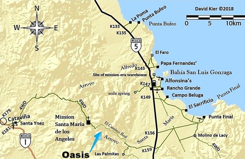
Is this the oasis? https://www.google.com/maps/place/Oasis+Santa+Mar%C3%ADa+o+P...
Traveling the Americas via my old land cruiser
|
|
|
David K
Honored Nomad
        
Posts: 65384
Registered: 8-30-2002
Location: San Diego County
Member Is Offline
Mood: Have Baja Fever
|
|
The map link shows the oasis they hiked to, but calling it a "Cataviña oasis" is a bit of a stretch. It is closer to Gonzaga Bay in the time to get
to and road + hiking distance.
While nothing historically has called it that, at some point, it got named La Poza de Escuadra. Kind of like when I named the grade near Mission Santa
Maria "The Widowmaker" in 1999 or the sand island near Percebu/Bahia Santa Maria "Shell Island" back in 1978! There are several YouTube videos if you
search "Escuadra".

|
|
|
canoe4me
Newbie
Posts: 12
Registered: 5-22-2016
Member Is Offline
|
|
That is the spot! I called it Oasis Cataviña because that’s what it was called by a Mexican ecotour company in their YouTube videos while guiding
guests to that location. They appeared to be guiding other Mexicans. I’ll call it what the locals call it. It’s totally worth the hike.
|
|
|
David K
Honored Nomad
        
Posts: 65384
Registered: 8-30-2002
Location: San Diego County
Member Is Offline
Mood: Have Baja Fever
|
|
The name "Mexico" seems to have given it is: "La Poza de Escuadra", but as the case of any place named, it depends on who repeats it. That name seems
to work best for YouTube videos of it. It is in the canyon of Arroyo Santa María, midway between Cataviña and the gulf coast ("Gonzaga Bay").
|
|
|
| Pages:
1
2
3 |

