| Pages:
1
2
3 |
shari
Select Nomad
      
Posts: 13052
Registered: 3-10-2006
Location: bahia asuncion, baja sur
Member Is Offline
Mood: there is no reality except the one contained within us "Herman Hesse"
|
|
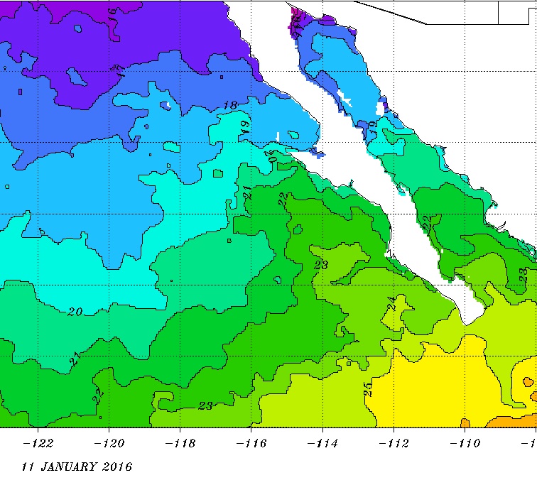
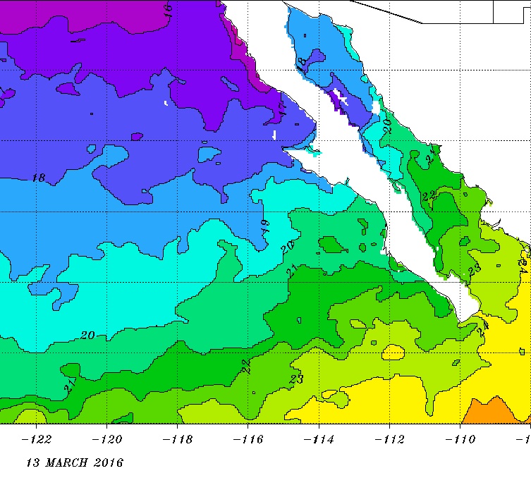
I know it is hard to believe and goes against some folks logic but the central Pacside is actually warmer than the gulf side in the winter...way
warmer than BOLA, Mulege & even Loreto.
This is because our water temps stay above 70 all winter long until late March(which is when our winter begins). We try to get a swim in
everyday...good for the soul! So don't be afraid to check out the Pacific side in the winter...you will be pleasantly surprised!

|
|
|
ehall
Super Nomad
   
Posts: 1906
Registered: 3-29-2014
Location: Buckeye, Az
Member Is Offline
Mood: It's 5 o'clock somewhere
|
|
Thanks Shari. I did not know that.
|
|
|
ReTire
Nomad
 
Posts: 129
Registered: 9-16-2018
Location: PNW
Member Is Offline
|
|
Yes. I envision some Pacific and Sea of Cortes time. Warmer than the Gulf side.? Then I need to check it out. I know I’m going to enjoy NOT having
an itenerary.
So, in this day and age I have to ask.....how well do cell phones work?
|
|
|
BajaTed
Senior Nomad
  
Posts: 859
Registered: 5-2-2010
Location: Bajamar
Member Is Offline
|
|
Every year an international group of us people that have B-days in Nov. go to a place called Muzik Mountain in the canyon above Burro beach and stay
for the month. Kinda like the Burning Man of Muelege
Es Todo Bueno
|
|
|
bajaric
Senior Nomad
  
Posts: 670
Registered: 2-2-2015
Member Is Offline
|
|
I should have clarified that my statement that the water gets colder south of the border applies to Northern Baja, on the Pacific side. This is a
localized phenomenon. At some point of course when you get far enough south the water warms up because you are nearing the tropics.
|
|
|
ReTire
Nomad
 
Posts: 129
Registered: 9-16-2018
Location: PNW
Member Is Offline
|
|
I have a B day in November!! Sounds interesting. But, my trip is in January...’this year’
Cold is relative though! That picture looks very inviting Shari!
|
|
|
shari
Select Nomad
      
Posts: 13052
Registered: 3-10-2006
Location: bahia asuncion, baja sur
Member Is Offline
Mood: there is no reality except the one contained within us "Herman Hesse"
|
|
Quote: Originally posted by ReTire  | Yes. I envision some Pacific and Sea of Cortes time. Warmer than the Gulf side.? Then I need to check it out.
So, in this day and age I have to ask.....how well do cell phones work? |
Telcel works great here and we also have new high speed internet in our campground, Inn and vacation rental houses.
|
|
|
wilderone
Ultra Nomad
    
Posts: 3894
Registered: 2-9-2004
Member Is Offline
|
|
Be sure to drive out to the whale watching launch beach at Ojo de Liebre just south of Guerrero Negro. It's another 1/2 hr. or so to the lagoon once
on that road - great campground - there's also a restaurant. Big sign on Mex. 1 at the turnoff.
|
|
|
David K
Honored Nomad
        
Posts: 65422
Registered: 8-30-2002
Location: San Diego County
Member Is Offline
Mood: Have Baja Fever
|
|
Quote: Originally posted by wilderone  | | Be sure to drive out to the whale watching launch beach at Ojo de Liebre just south of Guerrero Negro. It's another 1/2 hr. or so to the lagoon once
on that road - great campground - there's also a restaurant. Big sign on Mex. 1 at the turnoff. |
This is at KM 207.5, and is paved where it leaves Hwy. 1.
Remember, in Baja Sur, the kilometer markers increase northbound, the opposite of the northern state.
The Eagle Monument (state border) is KM 220.
|
|
|
ReTire
Nomad
 
Posts: 129
Registered: 9-16-2018
Location: PNW
Member Is Offline
|
|
his is at KM 207.5, and is paved where it leaves Hwy. 1.
Remember, in Baja Sur, the kilometer markers increase northbound, the opposite of the northern state.
Well now...that’s a handy tip!
|
|
|
David K
Honored Nomad
        
Posts: 65422
Registered: 8-30-2002
Location: San Diego County
Member Is Offline
Mood: Have Baja Fever
|
|
Looks like you cut off a bit of my wording... but yes, The kilometer numbers increase as you go south, with a new KM 0 at the U.S. Border, Ensenada,
San Quintin, L.A. Bay Highway, State Border.
They increase going North in Baja Sur, with a new KM 0 at Cabo San Lucas, La Paz, Cd. Insurgentes, Loreto, Santa Rosalia... and then the state border.
|
|
|
4x4abc
Ultra Nomad
    
Posts: 4454
Registered: 4-24-2009
Location: La Paz, BCS
Member Is Offline
Mood: happy - always
|
|
well...


[Edited on 11-17-2018 by 4x4abc]
Harald Pietschmann
|
|
|
ReTire
Nomad
 
Posts: 129
Registered: 9-16-2018
Location: PNW
Member Is Offline
|
|
Nice info on those maps! January looks good based on those. Cooler in March though.
Ha! I need to see what the waters off Oregon look like.
|
|
|
jbcoug
Senior Nomad
  
Posts: 709
Registered: 9-24-2006
Location: Vancouver, WA
Member Is Offline
Mood: Needing Baja!
|
|
Retire,
I have made the full trip down Baja three times in the last four years from the Portland area. If you want to talk, PM me.
John
\"The average dog is a nicer person than the average person.\" Andy Rooney
|
|
|
| Pages:
1
2
3 |

