| Pages:
1
2
3 |
David K
Honored Nomad
        
Posts: 65436
Registered: 8-30-2002
Location: San Diego County
Member Is Offline
Mood: Have Baja Fever
|
|
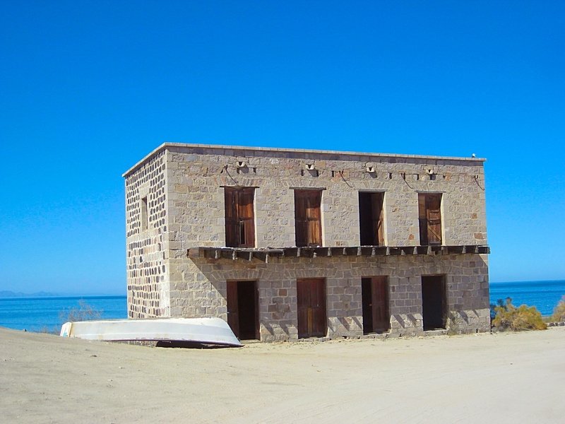
They do sell gasoline at El Barril, right next to the Ybarra House, the abandoned two(+) story brick building, when I was there.
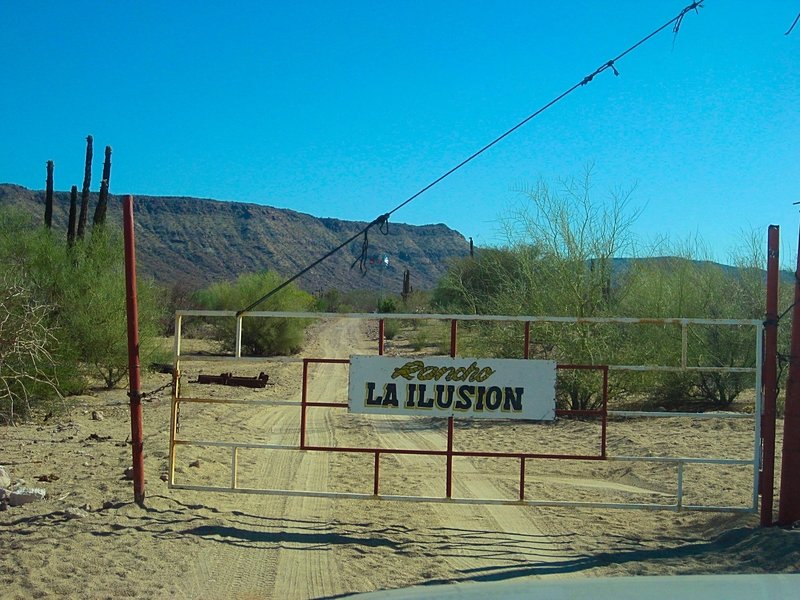
The first gate (not locked) is at the entrance to Rancho Ilusión. Ask there about the locked gates on south.
In 2017, the owner said the gates will not be locked unless it becomes necessary.


|
|
|
advrider
Super Nomad
   
Posts: 1920
Registered: 10-2-2015
Member Is Offline
|
|
JZ, or anyone else, how long from the highway into Agua Verde on a moto? We are on 990 Adventures but can ride pretty much anything on them. I tried
converting the tracks on the first page but they didn't work for me, I will have to give it another shot.
I did some searching and it looks like there might be a small restaurant but not much else? Plan on camping I'm guessing? Should we come off of
highway 1 South of Loreto or use the tracks from earlier out of Ciudad Insurgents? We will probably be coming from San Juanico.
|
|
|
colloquialoatmeal
Newbie
Posts: 12
Registered: 1-6-2020
Member Is Offline
|
|
Unless a lot has changed in 2y, you'll definitely be able to take the 990s down to Agua Verde
|
|
|
advrider
Super Nomad
   
Posts: 1920
Registered: 10-2-2015
Member Is Offline
|
|
Any idea how long it take to get there in a car or bike? Thanks for the reply. Any pictures, any food available?
|
|
|
JZ
Select Nomad
      
Posts: 13943
Registered: 10-3-2003
Member Is Offline
|
|
Quote: Originally posted by advrider  | JZ, or anyone else, how long from the highway into Agua Verde on a moto? We are on 990 Adventures but can ride pretty much anything on them. I tried
converting the tracks on the first page but they didn't work for me, I will have to give it another shot.
I did some searching and it looks like there might be a small restaurant but not much else? Plan on camping I'm guessing? Should we come off of
highway 1 South of Loreto or use the tracks from earlier out of Ciudad Insurgents? We will probably be coming from San Juanico.
|
It's super easy coming from MX 1 South of Loreto here: 25.608792° -111.315351°. About 24 miles. Very cool ride/drive down.
It's super hard coming from Constitucion or Insurgents (AV back door). Rock slides have totally washed out the road.
I could have done it on my KTM 250, but there was no way the truck was making it so we turned around. This was 2 years ago. I haven't heard anyone
say it's been fixed up yet.
[Edited on 2-10-2020 by JZ]
|
|
|
advrider
Super Nomad
   
Posts: 1920
Registered: 10-2-2015
Member Is Offline
|
|
We were debating taking our camping gear or just shooting in for a look around and back to Loreto for the night? We've never been so wanted to scout
for future camping trips. Any place to have lunch or get a beer.
|
|
|
JZ
Select Nomad
      
Posts: 13943
Registered: 10-3-2003
Member Is Offline
|
|
It's definitely an easy day trip from Loreto to AV and back. Have done it many times.
There is a very small market down there. Not sure if they cook or not. I'm guessing yes.
We've always brought our food.
|
|
|
advrider
Super Nomad
   
Posts: 1920
Registered: 10-2-2015
Member Is Offline
|
|
Perfect, thanks for the info, it's been on my list for a while..
|
|
|
colloquialoatmeal
Newbie
Posts: 12
Registered: 1-6-2020
Member Is Offline
|
|
Hey everyone, got back, writing a trip report that should be up soon but a couple points really quick RE: this thread:
Road to Agua Verde is more beat up than usual but still very passable on a moto of any size. They're doing road work right now to patch up some holes
and put new retaining walls in toward the entrance from the highway.
Road between Agua Verde and San Jose de la Noria has actually gotten much worse! I made it to KM 13 (from the turn off at the wash just north of Agua
Verde) and walked almost to the top of the hill. The road up to KM 13 was fairly technical in some spots, just tons of rocks. There are sections
beyond that are doable on a bike but if I would rate them as black diamond or even double black diamond. Very large sized rocks and super tight lines
between them. Massive drop offs in the road, some as high as 3-4m. No chance of a jeep getting through. I did find some track and someone has
definitely tried it at some point. I made a video and will upload it to youtube if anyone's interested in seeing the carnage!
Road to Tembabiche was super fun, very beautiful! The families in the town denied that there was a road to Los Delores or Los Burros and unfortunately
no one would sell me gas. Despite having a 3.4 gal tank, 1gal gas can, and 1l reserve bottle, my range on the WRF this trip was abysmal. I barely made
it out of Tembabiche; by the time I made it back to Cid Constitucion I was on fumes.
I'll post a full report including some very cool cave paintings but figured I'd drop a quick status report.
Oh, and Leonora does make food at Agua Verde, the place is called 'Brisa del Mar' and it's awesome food! She made me sashimi from some fish caught as
I was pulling up. Killer!
|
|
|
David K
Honored Nomad
        
Posts: 65436
Registered: 8-30-2002
Location: San Diego County
Member Is Offline
Mood: Have Baja Fever
|
|
Fantastic! Will enjoy seeing your trip report and video!
|
|
|
4x4abc
Ultra Nomad
    
Posts: 4454
Registered: 4-24-2009
Location: La Paz, BCS
Member Is Offline
Mood: happy - always
|
|
Quote: Originally posted by colloquialoatmeal  | Hey everyone, got back, writing a trip report that should be up soon but a couple points really quick RE: this thread:
Road to Agua Verde is more beat up than usual but still very passable on a moto of any size. They're doing road work right now to patch up some holes
and put new retaining walls in toward the entrance from the highway.
Road between Agua Verde and San Jose de la Noria has actually gotten much worse! I made it to KM 13 (from the turn off at the wash just north of Agua
Verde) and walked almost to the top of the hill. The road up to KM 13 was fairly technical in some spots, just tons of rocks. There are sections
beyond that are doable on a bike but if I would rate them as black diamond or even double black diamond. Very large sized rocks and super tight lines
between them. Massive drop offs in the road, some as high as 3-4m. No chance of a jeep getting through. I did find some track and someone has
definitely tried it at some point. I made a video and will upload it to youtube if anyone's interested in seeing the carnage!
Road to Tembabiche was super fun, very beautiful! The families in the town denied that there was a road to Los Delores or Los Burros and unfortunately
no one would sell me gas. Despite having a 3.4 gal tank, 1gal gas can, and 1l reserve bottle, my range on the WRF this trip was abysmal. I barely made
it out of Tembabiche; by the time I made it back to Cid Constitucion I was on fumes.
I'll post a full report including some very cool cave paintings but figured I'd drop a quick status report.
Oh, and Leonora does make food at Agua Verde, the place is called 'Brisa del Mar' and it's awesome food! She made me sashimi from some fish caught as
I was pulling up. Killer! |
can't wait for video and report!
Harald Pietschmann
|
|
|
advrider
Super Nomad
   
Posts: 1920
Registered: 10-2-2015
Member Is Offline
|
|
Anyone convert the two files that JZ posted to a GPX file? I have tried several times with no luck using GPS visualizer? Not sure why it's not working
but the file is not readable after it's converted.
|
|
|
JZ
Select Nomad
      
Posts: 13943
Registered: 10-3-2003
Member Is Offline
|
|
Quote: Originally posted by advrider  | | Anyone convert the two files that JZ posted to a GPX file? I have tried several times with no luck using GPS visualizer? Not sure why it's not working
but the file is not readable after it's converted. |
As you have heard me say a thousand times, ditch that old standalone GPS and run it on your phone with a big, beautiful, bright screen and fantastic
keyboard. You won't run into issues like this, as KMZ is imported natively into BCN.
Here's is another converter option if you still remain stubborn: https://www.gpsbabel.org.
[Edited on 2-28-2020 by JZ]
|
|
|
Jinete Viejo
Junior Nomad

Posts: 88
Registered: 1-23-2017
Member Is Offline
|
|
Quote: Originally posted by advrider  | | Anyone convert the two files that JZ posted to a GPX file? I have tried several times with no luck using GPS visualizer? Not sure why it's not working
but the file is not readable after it's converted. |
Rather than "Convert a File" on GPS Visualizer, instead do "Draw on a Map", then import JZ's tracks, and then save them as a GPX. "Draw on a Map" is
right below "Convert a File" at the top of the screen.
[Edited on 2-28-2020 by Jinete Viejo]
[Edited on 2-28-2020 by Jinete Viejo]
Attachment: Area Around Timbabichi.gpx (55kB)
This file has been downloaded 288 times
[Edited on 2-28-2020 by Jinete Viejo]
|
|
|
advrider
Super Nomad
   
Posts: 1920
Registered: 10-2-2015
Member Is Offline
|
|
Never tried that, thanks!
|
|
|
| Pages:
1
2
3 |

