| Pages:
1
2
3
4
5 |
4x4abc
Ultra Nomad

Posts: 4455
Registered: 4-24-2009
Location: La Paz, BCS
Member Is Offline
Mood: happy - always
|
|
so,
we have:
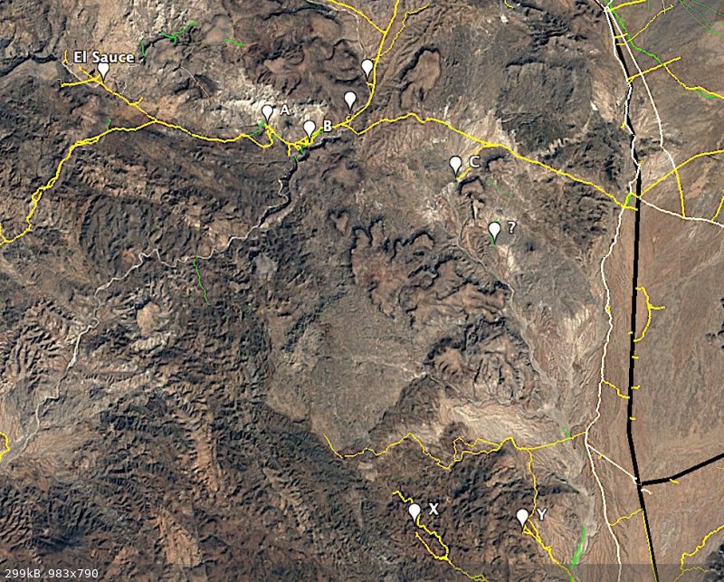
El Sauce
San Antonio - Codornices (A)
Codornices Nuevo (B)
Agua de Leon - Keda (C)
Kanin (?)
Mina Leon Grande (X)
Mina s/n (Y)
NE of B is where Don Jose Cota (the owner of much of the area) lives?
does anyone have a name for the ranch site (has Corral and Pila) NE of Don Jose Cota's place? The northern most pin
Harald Pietschmann
|
|
|
David K
Honored Nomad
Posts: 65562
Registered: 8-30-2002
Location: San Diego County
Member Is Offline
Mood: Have Baja Fever
|
|
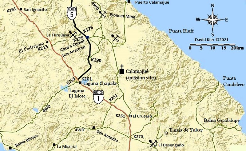
Harald, have you been to Agua Leon since we see now a road goes to it? I don't recall seeing it when I was going west from the highway. The incident
at La Miseria was the overriding memory of that day!
|
|
|
4x4abc
Ultra Nomad
Posts: 4455
Registered: 4-24-2009
Location: La Paz, BCS
Member Is Offline
Mood: happy - always
|
|
have not been to Agua Leon
yes, road is new
recent ranching activities
Harald Pietschmann
|
|
|
David K
Honored Nomad
Posts: 65562
Registered: 8-30-2002
Location: San Diego County
Member Is Offline
Mood: Have Baja Fever
|
|
I will scan Linck's diary of those days! Check back tomorrow!
|
|
|
4x4abc
Ultra Nomad
Posts: 4455
Registered: 4-24-2009
Location: La Paz, BCS
Member Is Offline
Mood: happy - always
|
|
now we have to find that other Yubay
Harald Pietschmann
|
|
|
4x4abc
Ultra Nomad
Posts: 4455
Registered: 4-24-2009
Location: La Paz, BCS
Member Is Offline
Mood: happy - always
|
|
using this for now
it reinforces that there was indeed another Yubai
see footnote 51
https://ia801304.us.archive.org/2/items/ELVIAJEDEWENCESLAOLI...
[Edited on 7-24-2021 by BajaNomad]
Harald Pietschmann
|
|
|
David K
Honored Nomad
Posts: 65562
Registered: 8-30-2002
Location: San Diego County
Member Is Offline
Mood: Have Baja Fever
|
|
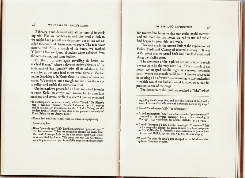
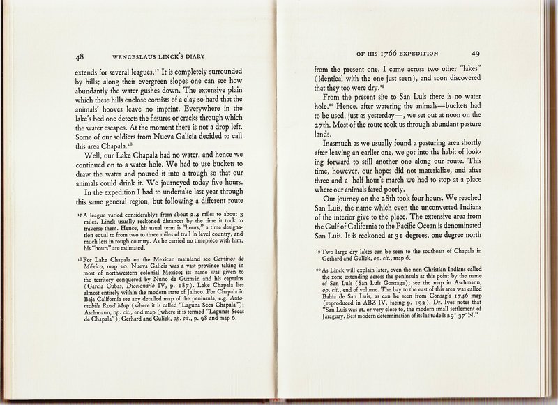
Linck's Diary from the 1766 Expedition, in English
The 1766 Expedition diary was translated by Ernest J. Burrus, S.J. and published in 1966.
I will post the first few pages of the expedition diary and the map covering those days. These cover the sites of Kanin, Keda, Laguna Chapala, and San
Luis:
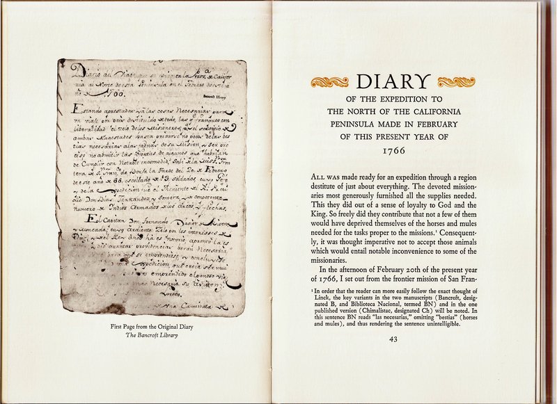

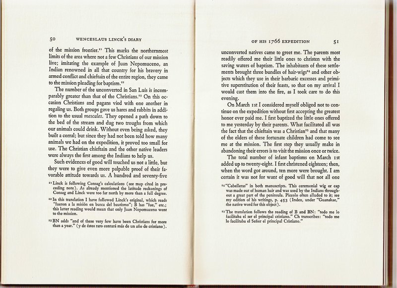
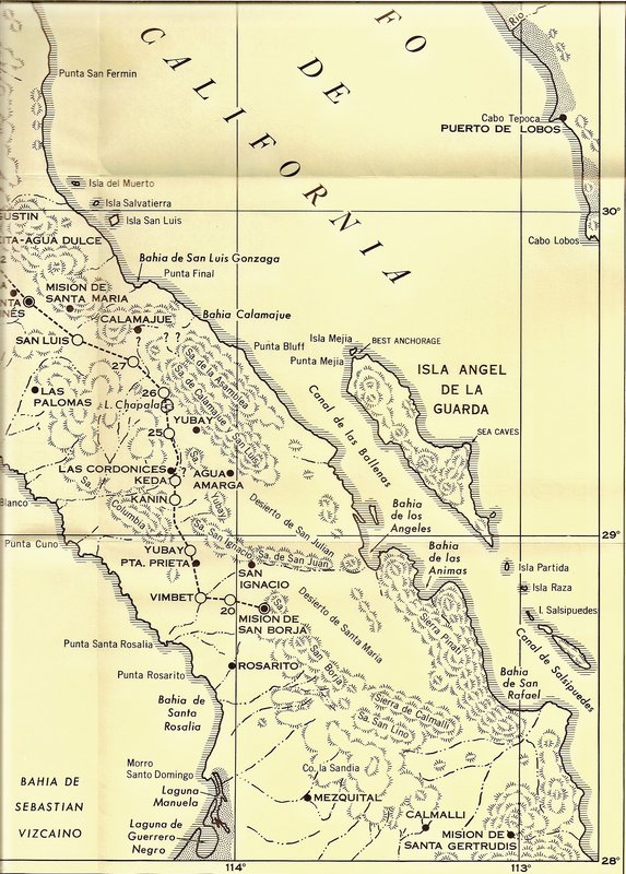
['San Ignacio' (mentioned above) is not the mission to the south but here was a visita of Mission San Borja and today is Rancho San Ignacito.]
*Addition pages and the rest of the map available, upon request.
|
|
|
4x4abc
Ultra Nomad
Posts: 4455
Registered: 4-24-2009
Location: La Paz, BCS
Member Is Offline
Mood: happy - always
|
|
thanks David.
What always amazes me reading the old trip logs - these guys were tough as nails.
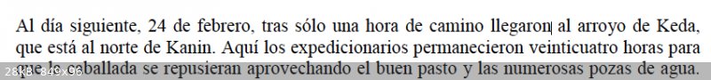
Linck's first day
33 Kilometers (21 miles) in 4 hours?
without a well maintained trail/road?
WOW!
Kanin to Keda (7.5 km as the crow flies) in one hour.
Wow again.
Harald Pietschmann
|
|
|
David K
Honored Nomad
Posts: 65562
Registered: 8-30-2002
Location: San Diego County
Member Is Offline
Mood: Have Baja Fever
|
|
How accurate were the times, I wonder? They didn't have watches or gps! Sun position, I guess? However, they often began well before dawn.
|
|
|
David K
Honored Nomad
Posts: 65562
Registered: 8-30-2002
Location: San Diego County
Member Is Offline
Mood: Have Baja Fever
|
|
Quote: Originally posted by Lance S.  |
Well, I don't believe there is another Yubay.
While at Keda Linck mentions that it is the northern most point reached by the earlier Consag expedition. Apparently because of this, Dr. Ives, on
who's opinion the map is based, assumed that Linck followed Consag's route up to Keda. This is what we get on the map. It was also a route Ives
could follow in a car. This was in the 50's or 60's (?). In order to make that route work Ives decides that there must be another place called Yubay
north east of Punta Prieta. He does not know where it is but it must be there or his proposed route doesn't work.
Today with google earth and the baja almanac I think a strong argument can be made that Yubay was Yubay. It's pretty clear based on the times
traveled between points and the site descriptions.
Should probably start another thread.
|
The Dr. Ronald Ives-made map could be revised with our improved details and maps! In the diary, many footnotes are conversations with Dr. Ives on the
place names and routes, two places called Yubay, etc.
|
|
|
4x4abc
Ultra Nomad
Posts: 4455
Registered: 4-24-2009
Location: La Paz, BCS
Member Is Offline
Mood: happy - always
|
|
| Quote: Originally posted by Lance S. |
La Primera Entrada , Carlos Lazcano Sahagun (2000) contains the Spanish text of the expedition. Maybe David can ask if it is available online. He
posted a link to Sahaguns publication of the Consag diary. |
which page?
I have the book, but can't find the Linck diary
Harald Pietschmann
|
|
|
4x4abc
Ultra Nomad
Posts: 4455
Registered: 4-24-2009
Location: La Paz, BCS
Member Is Offline
Mood: happy - always
|
|
my bad - I have the "Vestigios" book
Harald Pietschmann
|
|
|
David K
Honored Nomad
Posts: 65562
Registered: 8-30-2002
Location: San Diego County
Member Is Offline
Mood: Have Baja Fever
|
|
Ives shows Linck going west, then north... and incorrectly locates San Ignacio (Ignacito) to the north, as it was not visited by Linck.
Lance has solved the confusion by showing Linck going north, then west. Linck did not see San Ignacio (Ignacito) because it is to the west of San
Borja, and he went north!
On the 1962 Gulick map, it is easy to see all the points except Agua Leon:

[Edited on 7-25-2021 by David K]
|
|
|
4x4abc
Ultra Nomad
Posts: 4455
Registered: 4-24-2009
Location: La Paz, BCS
Member Is Offline
Mood: happy - always
|
|
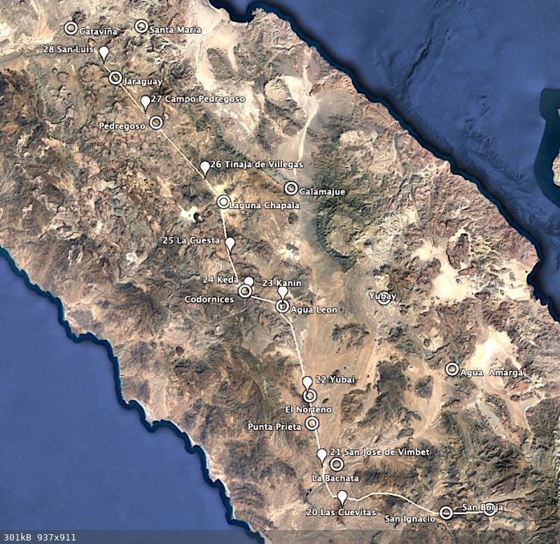
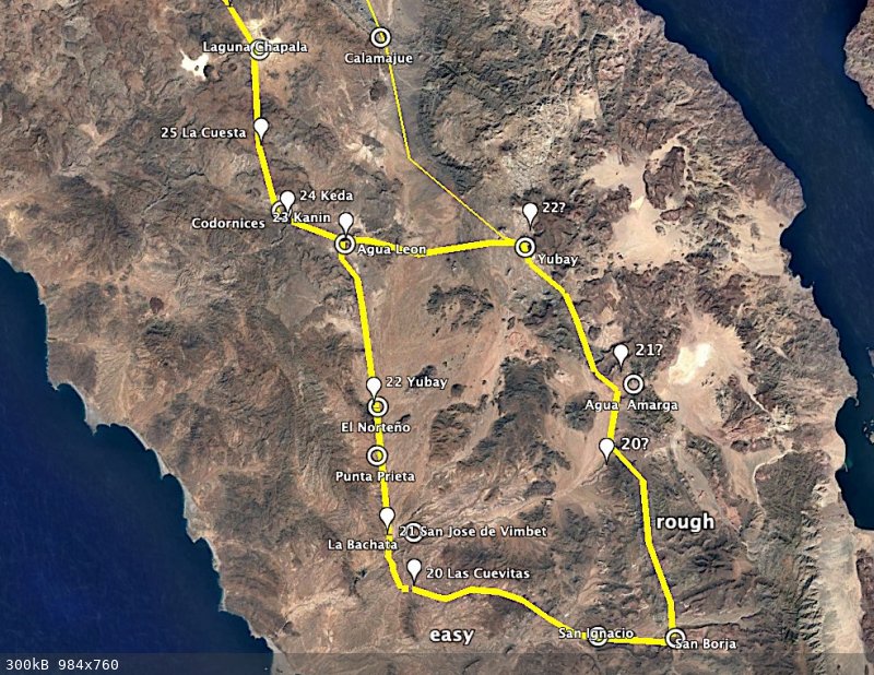
what I have so far
found most of the trail between San Ignacio and Las Cuevitas
found most of the trail between Codornices and Laguna Chapala
located the mountain pass mentioned
found all the water sources
Harald Pietschmann
|
|
|
David K
Honored Nomad
Posts: 65562
Registered: 8-30-2002
Location: San Diego County
Member Is Offline
Mood: Have Baja Fever
|
|
See Lance's post above mine. San José de Vimbet is Agua Amarga, then the one and only Yubay was next. ??
|
|
|
4x4abc
Ultra Nomad
Posts: 4455
Registered: 4-24-2009
Location: La Paz, BCS
Member Is Offline
Mood: happy - always
|
|
there is more than one place with bitter water
it is established that Vimbet is La Bachata
Harald Pietschmann
|
|
|
PaulW
Ultra Nomad
Posts: 3113
Registered: 5-21-2013
Member Is Offline
|
|
My GPS map has always shown Yubay in large text. I assumed the label represented a general arena near Coco including the mountains east of Hwy5
|
|
|
David K
Honored Nomad
Posts: 65562
Registered: 8-30-2002
Location: San Diego County
Member Is Offline
Mood: Have Baja Fever
|
|
Yubay is a tinaja up in a granite walled canyon, about a kilometer off the main El Camino Real route.
Here it is, on my map:
Access from El Desengaño.

Trail to Yubay, which is straight ahead.
Standing on the boulder ledge, above the water hole...

Tinaja de Yubay in July 2001 (low water level).
GPS: N29°10.69' W113°59.26' (WGS 84) elev. 2,059'
Neal Johns has some good photos when it was overfilled with water in Feb. 2003:
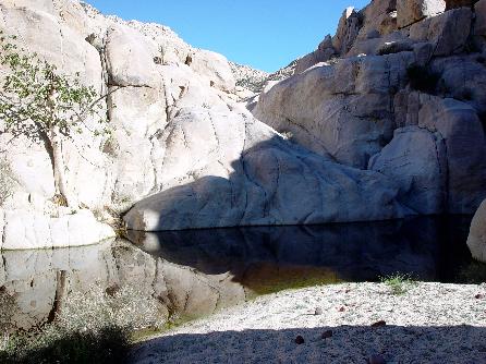
Note the fig tree on the rock to the left. That is what tells you that you have found the true Yubay!
|
|
|
David K
Honored Nomad
Posts: 65562
Registered: 8-30-2002
Location: San Diego County
Member Is Offline
Mood: Have Baja Fever
|
|
The region is Yubay, and the waterhole is the Tinaja de Yubay. On maps you will see arroyos named Yubay, etc. On older maps, there are spelling
variations.
|
|
|
4x4abc
Ultra Nomad
Posts: 4455
Registered: 4-24-2009
Location: La Paz, BCS
Member Is Offline
Mood: happy - always
|
|
IF they had taken the route north to Agua Amarga (close to Agua Higuera negating the comment that there is no water near Vimbet) then San Ignacio
would have been to the west
there is no (meager) grass between San Borja and Agua Amarga
there is not even a glimpse of water anywhere
Agua Amarga has absolutely no grass
La Bachata does - water at La Bachata is bitter (agua amarga)
the terrain between Borja and Agua Amarga is very challenging
I doubt they could have done it in 7.5 hours
the terrain between San Borja and the disputed Yubay is easy
it has a well pronounced trail that is still visible today
IF they had taken the route to Agua Amarga and then to the known Yubay since the goal was to travel far north, it would have made more sense to
continue to Calamajue with known water sources on the way
but Linck had explored that route already the year before
the known Yubay has no grass
the disputed Yubay does
traveling west from the known Yubay to Kanin is a much tougher route than from the disputed Yubay to Kanin
I suspect San Ignacio is not mentioned because it is so close to San Borja that it had no impact on the travel that day
[Edited on 7-26-2021 by 4x4abc]
[Edited on 7-26-2021 by 4x4abc]
Harald Pietschmann
|
|
|
| Pages:
1
2
3
4
5 |


