| Pages:
1
2
3
4 |
TMW
Select Nomad
      
Posts: 10659
Registered: 9-1-2003
Location: Bakersfield, CA
Member Is Offline
|
|
We're going to start down on Thursday the 8th. I don't know if we'll be there Thursday evening as I want to try another route into the plane wreck we
found last July. We'll be in San Felipe Friday morning for contingency then maybe check out the wash after lunch. The road you found was it south of
Matomi?
[Edited on 2-25-2007 by TW]
|
|
|
David K
Honored Nomad
        
Posts: 65433
Registered: 8-30-2002
Location: San Diego County
Member Is Offline
Mood: Have Baja Fever
|
|
| Quote: | Originally posted by bajalou
Some people just can't wait. Told a few neighbors about it and they had to go yesterday. - Remember, we're in Baja Bugs and desert rails - no MCs.
There is a road into the mouth of the canyon from Hghy 5 but we only found it on our way out.
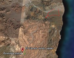
This shows where we went - from Matomi to the canyon and back out to the highway. (red) and points for the mine and upper canyon near the lower left.

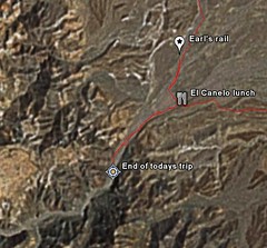
This shows our gong into the mouth - about a mile from the lunch spot.

There were motorcycle tracks going on beyond where we went. Because of a broken axle on a rail and time of day we turned around there but know we can
drive further up the canyon on another day. Where we stopped we were at about 635 ft elevation. Longer days will help when we go back again.
[Edited on 2-24-2007 by bajalou] |
Lou,
You are showing something different than the La Turquesa Canyon route... which is between Gonzaga and Coco's Corner. Your route looks to be on or near
the Bill Nichol's Trail, which starts about 8 miles south of Puertecitos...?
I am interested in this route as well, perhaps start a new thread in the Off Road or Trip Reports Forum to make it easy to find on Nomad... and make
the images larger, please???
|
|
|
bajalou
Ultra Nomad
    
Posts: 4459
Registered: 3-11-2004
Location: South of the broder
Member Is Offline
|
|
See you at contingency - but the coords for the turn from H5 are
30 27.4765 -114 39.4075
That is Deg and min only
There is a white van just off the highway right where you turn in on the road. One "Y" in the road a mile or so in, stay to the right. The road
eventually crosses the El Canelo wash about 1/2 mile from the mouth of its canyon.
From H 5 it is about 22 miles to the curve nearest the mine. (Made a track in GoogleEarth, converted to Ozi to get measurement).
If you get here earlier, come on by.
No Bad Days
\"Never argue with an idiot. People watching may not be able to tell the difference\"
\"The trouble with doing nothing is - how do I know when I\'m done?\"
Nomad Baja Interactive map
And in the San Felipe area - check out Valle Chico area |
|
|
bajalou
Ultra Nomad
    
Posts: 4459
Registered: 3-11-2004
Location: South of the broder
Member Is Offline
|
|
| Quote: | Originally posted by David K
You are showing something different than the La Turquesa Canyon route... which is between Gonzaga and Coco's Corner. Your route looks to be on or near
the Bill Nichol's Trail, which starts about 8 miles south of Puertecitos...?
I am interested in this route as well, perhaps start a new thread in the Off Road or Trip Reports Forum to make it easy to find on Nomad... and make
the images larger, please??? |
Just thinking about the thread. My posts etc are regarding TW's El Canelo and mine with roads to H1 post.
No Bad Days
\"Never argue with an idiot. People watching may not be able to tell the difference\"
\"The trouble with doing nothing is - how do I know when I\'m done?\"
Nomad Baja Interactive map
And in the San Felipe area - check out Valle Chico area |
|
|
David K
Honored Nomad
        
Posts: 65433
Registered: 8-30-2002
Location: San Diego County
Member Is Offline
Mood: Have Baja Fever
|
|
Lou, TW's Google Earth pictures are of the road to the Green Pools and past the Turquoise Mine to the trail Baja Angel and I hiked partway down last
weekend (what this thread is about)... Kacey Smith's XR Ride/ Coco's Shortcut.
|
|
|
bajalou
Ultra Nomad
    
Posts: 4459
Registered: 3-11-2004
Location: South of the broder
Member Is Offline
|
|
Sorry David, guess TW's post about this was in another thread -
No Bad Days
\"Never argue with an idiot. People watching may not be able to tell the difference\"
\"The trouble with doing nothing is - how do I know when I\'m done?\"
Nomad Baja Interactive map
And in the San Felipe area - check out Valle Chico area |
|
|
David K
Honored Nomad
        
Posts: 65433
Registered: 8-30-2002
Location: San Diego County
Member Is Offline
Mood: Have Baja Fever
|
|
No worries Lou... I do want to see more of the trail you are talking about!
A short cut between Hwy. 1 and 5 is what we seek... The La Turquesa Canyon route is only 12 miles north of Chapala, so is not that great of a
benefit... However, a route closer to Puertecitos like the one you showed would be a great way to save over 100 miles of driving!
[Edited on 2-25-2007 by David K]
|
|
|
David K
Honored Nomad
        
Posts: 65433
Registered: 8-30-2002
Location: San Diego County
Member Is Offline
Mood: Have Baja Fever
|
|
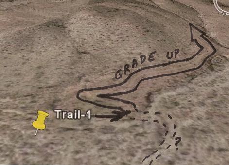
If it helps you explorers find the bottom of the grade in La Turquesa Canyon better, I bordered the road with a marker... There is a small switchback
at the bottom which puts the point where the old mine road reaches the arroyo to the north of the Trail-1 dart in TW's awesome images...

|
|
|
| Pages:
1
2
3
4 |

