| Pages:
1
2
3
4
5
6
..
11 |
woody with a view
PITA Nomad

Posts: 15940
Registered: 11-8-2004
Location: Looking at the Coronado Islands
Member Is Offline
Mood: Everchangin'
|
|
how much will the tolls cost after repairs are completed?
|
|
|
aguachico
Senior Nomad
Posts: 602
Registered: 3-23-2007
Location: tijuana
Member Is Offline
Mood: logic cannot get thru to the illogical
|
|
| Quote: | Originally posted by woody with a view
how much will the tolls cost after repairs are completed? |
Just thinking about this also and whether they will continue to charge at all? They should at least stop charging at rosarito and ensenada!
|
|
|
mtgoat666
Platinum Nomad
Posts: 21051
Registered: 9-16-2006
Location: San Diego
Member Is Online
Mood: Hot n spicy
|
|
| Quote: | Originally posted by Nookster
Anybody got the skills to post this location on google maps? |
Look at the OC Register article. Had a nice google earth graphic link
|
|
|
wilderone
Ultra Nomad
Posts: 3906
Registered: 2-9-2004
Member Is Offline
|
|
12/29 TJ-Ensenada Toll road collapse near Salispuedes
ENSENADA Days after a 4.6-magnitude earthquake struck south of Ensenada, the Tijuana-Ensenada toll road has collapsed toward the sea and threatens
to continue sinking, though no injuries were reported.
The scenic road had already seen evidence of fractures and sinking since Dec. 19, the day of the earthquake, with many travelers posting pictures on
social media of the increasingly critical situation of the highway. However, no official confirmation from geologist or road engineers have confirmed
the collapse is due to the earthquake, with only the state government saying that "natural causes" were to blame.
Saturday morning, the small fractures suddenly turned into enormous cracks on the cliffside, plunging the highway deeper and toward the sea, with some
parts caving almost 300 feet.
The collapse happened at the Salsipuedes stretch of highway toward Ensenada overlooking steep bluffs, only about 10 miles north of Ensenada and the
San Miguel toll booth, and 56 miles south of the border.
Authorities will now close the highway from the La Misión toll to the San Miguel toll, forcing travelers to take the old non-toll road from La Misión
to Ensenada, an alternate route of about 30 miles (although, not much difference in total travel time and goes through the countryside).
Also, the Baja state government advises travelers to take Federal Road 3 if they are heading out from Tecate toward Ensenada, or use the old Ensenada
- San Felipe road for trips from Mexicali to Ensenada, or vice versa.
There are conflicting accounts about just how long the highway will remain closed. Frontera reports that Rosa María Castañeda, regional director of
the Federal Roads and Bridges agency responsible for the highway, has said that it might only take a week until the road reopens. Other reports put
the total time needed for repairs at one year.
State Civil Protection director Antonio Rosquillas said early Saturday morning that the collapse began to worsen around 2:30 a.m.
Meanwhile, the mayor of Ensenada, Gilberto Hirata, has blamed Capufe for not closing the highway stretch between La Misión and Ensenada earlier, even
after reports of serious faults started to appear on social media and at the urging of state officials.
He also stated that they were in talks with federal and state authorities about constructing an alternate road or replacing the highway with a bridge
or another road after years of trouble with the current scenic route.
The collapse would be devastating for the city of Ensenada and to the overall economy of the state, as the city is home to the third busiest cruise
ship terminal in Mexico and gateway to the rest of Baja by the sea.
|
|
|
dasubergeek
Senior Nomad
Posts: 694
Registered: 8-17-2013
Member Is Offline
|
|
| Quote: | Originally posted by mtgoat666
| Quote: | Originally posted by Nookster
Anybody got the skills to post this location on google maps? |
Look at the OC Register article. Had a nice google earth graphic link |
OC Weekly... I don't think the OC Register has picked it up, which is surprising. That's my article, and the map link in it is the same one I created
and linked upthread here. Full service around here at Baja Nomad! 
|
|
|
elgatoloco
Ultra Nomad
Posts: 4354
Registered: 11-19-2002
Location: Yes
Member Is Offline
|
|
That clears it up. Road will be reopened in a week. Or a year. Or never? Yikes.
MAGA
marooons Are Governing America
|
|
|
durrelllrobert
Elite Nomad
Posts: 7393
Registered: 11-22-2007
Location: Punta Banda BC
Member Is Offline
Mood: thriving in Baja
|
|
And the Federales say ...
"MEXICO CITY: Mexico says a 300-yard (metre) section of a highway near the US border has collapsed, sinking about 100 feet (30 metres) after a series
of small earthquakes.
Mexico's federal highway authority says the collapse occurred about 58 miles (93 kilometres) south of the border city of Tijuana. The road leads to
the port city of Ensenada, on the Baja California peninsula.
The agency, on Saturday said that the road was closed in the early morning hours, after the collapse was detected.
The agency said the collapse was caused by seven small earthquakes ranging in magnitude from 1.3 to 4.3. It said the roadway runs
over a known geological fault in the area, and that it had been raining heavily. No injuries were reported.
Traffic was being diverted onto a smaller, non-toll highway."
Bob Durrell
|
|
|
micah202
Super Nomad
Posts: 1615
Registered: 1-19-2011
Location: vancouver,BC
Member Is Offline
|
|
.
...can anyone say they're surprised???
....it was always a question of when,,,not 'if'.
......I'm glad to hear nobody got hurt!
|
|
|
wilderone
Ultra Nomad
Posts: 3906
Registered: 2-9-2004
Member Is Offline
|
|
Looking at some of the photos, it's not surprising that this happened - just asphalt over sand with the force of cliffs pushing on it - and in
earthquake country - just give it a little nudge and ....
Will be interesting to see how the Mex. 1 section will be "fixed".
I have been impressed with the bridges they built after some of the floods a few years ago.
|
|
|
bajaguy
Elite Nomad
Posts: 9247
Registered: 9-16-2003
Location: Carson City, NV/Ensenada - Baja Country Club
Member Is Offline
Mood: must be 5 O'clock somewhere in Baja
|
|
Bridge???
I don't think it is that easy. The fault area begins as one exits the San Miguel toll booth north where you can see patching and cracks in the
pavement to the El Mirador Lookout/Rest area, next to the "new" LNG plant at BajaMar.
Would be interesting to see what a geological review panel has to say about construction in that area.
Looks like a couple of safe alternative routes wiuld be to cut east at either at La Salina or through Jatay to the Free Road, then 4 lane the free
road to San Miguel......
Only time will tell
| Quote: | Originally posted by EngineerMike
Suspension bridge over the unstable section. Easy peasy. |
|
|
|
Rumple
Newbie
Posts: 15
Registered: 12-24-2013
Location: Punta Banda, Baja, Mexico
Member Is Offline
|
|
I have a friend who drove south yesterday afternoon. There was a detour in place and he said the condition of the free road was good, even newly
paved in part. Traffic moved well. The only glitch was the military check point that caused a 30 minute delay!
|
|
|
dasubergeek
Senior Nomad
Posts: 694
Registered: 8-17-2013
Member Is Offline
|
|
| Quote: | Originally posted by Rumple
I have a friend who drove south yesterday afternoon. There was a detour in place and he said the condition of the free road was good, even newly
paved in part. Traffic moved well. The only glitch was the military check point that caused a 30 minute delay! |
There's usually a military checkpoint northbound on the toll road at San Miguel, so this isn't TOO different. They had a military checkpoint at the
turnoff for El Tigre and the wine route, but the last several times I drove through there it was gone. The state government asked the military to
replace the checkpoints that were removed, so perhaps the military complied.
They have been paving the free road and the last I checked it was new pavement all the way up to the windy, hilly section east of La Misión. There was
construction the last time I went through but it's been a month or two so possibly they finished just in the nick of time.
|
|
|
Ken Cooke
Elite Nomad
Posts: 8971
Registered: 2-9-2004
Location: Riverside, CA
Member Is Offline
Mood: Pole Line Road postponed due to injury
|
|
Scenic Mexico coastal highway collapses after rain, small earthquakes: reports
http://worldnews.nbcnews.com/_news/2013/12/29/22094081-sceni...
By Alastair Jamieson, Staff writer, NBC News
A 300-yard section of scenic highway near the U.S. border collapsed Saturday, sinking up to 300 feet and forcing the closure of the route, according
to reports.
Mexicos federal highway authority says the collapse occurred about 58 miles south of the border city of Tijuana, according to The Associated Press.
The road leads to the port city of Ensenada, on the Baja California peninsula.
The agency said it came after several earlier small earthquakes, ranging in magnitude from 1.3 to 4.3, combined with recent heavy rainfall, the AP
reported.
The road had already seen evidence of fractures and sinking in recent days, according to a San Diego Union-Tribune report which said the small
fractures suddenly turned into enormous cracks on the cliffside in the early hours of Saturday, plunging the highway deeper and toward the sea, with
some parts caving almost 300 feet.
|
|
|
durrelllrobert
Elite Nomad
Posts: 7393
Registered: 11-22-2007
Location: Punta Banda BC
Member Is Offline
Mood: thriving in Baja
|
|
Here's the culprit
Fault line crosses under the bay and Punta Banda:
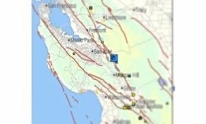
Bob Durrell
|
|
|
Whale-ista
Super Nomad
Posts: 2011
Registered: 2-18-2013
Location: San Diego
Member Is Offline
Mood: Sunny with chance of whales
|
|
The island of Punta Banda: work in progress
Isla Todos Santos was formed the same way.
It's a toss up which will be completed first: the island or a permanent coastal road route between La Mision/Ensenada. 
Here's another fault line map of Northern Baja California, including the Santo Thomas Valley/Punta Banda split. Lots of movement potential all along
this coast.
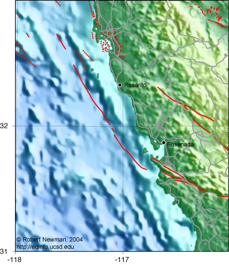
[Edited on 12-29-2013 by Whale-ista]
\"Probably the airplanes will bring week-enders from Los Angeles before long, and the beautiful poor bedraggled old town will bloom with a
Floridian ugliness.\" (John Steinbeck, 1940, discussing the future of La Paz, BCS, Mexico)
|
|
|
David K
Honored Nomad
Posts: 65549
Registered: 8-30-2002
Location: San Diego County
Member Is Offline
Mood: Have Baja Fever
|
|
| Quote: | Originally posted by durrelllrobert
Fault line crosses under the bay and Punta Banda:
|
Wrong bay and point map... but I am sure they are just as diced-up!
|
|
|
wetto
Nomad
Posts: 119
Registered: 10-28-2013
Location: Grass Valley, CA / Mulege
Member Is Offline
|
|
Once a journey is designed, equipped, and put in process, a new factor enters and takes over. A trip, a safari, an exploration, is an entity,
different from all other journeys. It has personality, temperament, individuality, uniqueness. A journey is a person in itself; no two are alike. And
all plans, safeguards, policing, and coercion are fruitless. We find after years of struggle that we do not take a trip; a trip takes us. Tour
masters, schedules, reservations, brass-bound and inevitable, dash themselves to wreckage on the personality of the trip. Only when this is recognized
can the blown-in-the glass bum relax and go along with it. Only then do the frustrations fall away. In this a journey is like marriage. The certain
way to be wrong is to think you control it.
― John Steinbeck
Lee S
|
|
|
EnsenadaDr
Banned
Posts: 5027
Registered: 9-12-2011
Location: Baja California
Member Is Offline
Mood: Move on. It is just a chapter in the past, but don't close the book- just turn the page
|
|
Bob what is this stauch denial from members here as well as the PBBB that earthquakes were not involved? I don't get it. | Quote: | Originally posted by durrelllrobert
"MEXICO CITY: Mexico says a 300-yard (metre) section of a highway near the US border has collapsed, sinking about 100 feet (30 metres) after a series
of small earthquakes.
Mexico's federal highway authority says the collapse occurred about 58 miles (93 kilometres) south of the border city of Tijuana. The road leads to
the port city of Ensenada, on the Baja California peninsula.
The agency, on Saturday said that the road was closed in the early morning hours, after the collapse was detected.
The agency said the collapse was caused by seven small earthquakes ranging in magnitude from 1.3 to 4.3. It said the roadway runs
over a known geological fault in the area, and that it had been raining heavily. No injuries were reported.
Traffic was being diverted onto a smaller, non-toll highway." |
|
|
|
David K
Honored Nomad
Posts: 65549
Registered: 8-30-2002
Location: San Diego County
Member Is Offline
Mood: Have Baja Fever
|
|
It is an unstable cliff, as many are next to the ocean. It didn't need an earthquake to slide, but if there are quakes it sure helps the ground to
move. Maybe the government needs to publish the earthquake story to keep protests down that the highway should have never been constructed there...?
The view seemed to be more important when picking the route above Salsipuedes beach?
|
|
|
woody with a view
PITA Nomad
Posts: 15940
Registered: 11-8-2004
Location: Looking at the Coronado Islands
Member Is Offline
Mood: Everchangin'
|
|
when was the last rainfall? it's been 80 degree santa ana weather since forever!
|
|
|
| Pages:
1
2
3
4
5
6
..
11 |


