| Pages:
1
2
3
4
5 |
bajabuddha
Banned
Posts: 4024
Registered: 4-12-2013
Location: Baja New Mexico
Member Is Offline
Mood: Always cranky unless medicated
|
|
The island is not the tombolo...... just the attaching sand spit covered by high tide.
I don't have a BUCKET LIST, but I do have a F***- IT LIST a mile long!
86 - 45*
|
|
|
Skipjack Joe
Elite Nomad

Posts: 8092
Registered: 7-12-2004
Location: Bahia Asuncion
Member Is Offline
|
|
Read below. 'Shell Island' is not island. It's a barrier spit, part of the beach it's connected. Whatever that beach is called, that's what 'Shell
Island' is named. Since it encloses Percebu Lagoon that's it's true name. Islands are permanently completely bordered by water.
http://www.fws.gov/cbra/Act/Coastal_Barriers.html
Types of Coastal Barrier Landforms
Coastal barrier landforms may be described by their relationships to the mainland as bay barriers, tombolos, barrier spits, and barrier islands.
Additional areas which function as coastal barriers include dune and beach barriers, and fringing mangroves. The term "mainland" includes the
continental land mass as well as large islands such as Long Island, New York and the Hawaiian Islands. Definitions of the various kinds of coastal
barriers follow:
Bay barriers - coastal barriers that connect two headlands, and enclose a pond, marsh, or other aquatic habitat. The terms bay mount bar and bay
bar are synonymous.
Tombolos - sand or gravel beaches which connect one or more offshore islands to each other or to the mainland. The terms connecting bar, tie bar,
and tying bar are synonymous.
Barrier spits - coastal barriers that extend into open water and are attached to the mainland at only one end. They can develop into a bay barrier
if they grow completely across a bay or other aquatic habitat. On the other hand, bay barriers can become spits if an inlet is created.
Barrier islands - coastal barriers completely detached from the mainland. Barrier spits may become barrier islands if their connection to the
mainland is severed by creation of a permanent inlet. The barrier island represents a broad barrier beach, commonly sufficiently
above high tide to have dunes, vegetated zones, and wetland areas.
Dune or beach barriers - broad sandy barrier beaches, with hills or ridges of sand formed by winds, which protect landward aquatic habitats.
Fringing mangroves - bands of mangrove along subtropical or tropical mainland shores in areas of low wave energy. Many of these areas are located
behind coral reefs, which together with the mangroves themselves, provide significant protection for the mainland from storm impact.
|
|
|
Skipjack Joe
Elite Nomad
Posts: 8092
Registered: 7-12-2004
Location: Bahia Asuncion
Member Is Offline
|
|
My wife's family used to vacation on the Stanislaus River, Central California. There was a swimming hole downstream which the kids liked to go to in
the afternoons. In order to get there they had to cross a large treeless flat that was so hot it would burn your bare feet when you crossed it. The
kids named it "Sahara" because to them it felt like Africa. The name stuck and they used it for years.
'Shell Beach' has the same origins. There is no actual 'Shell Beach'.
[Edited on 5-14-2015 by Skipjack Joe]
|
|
|
PaulW
Ultra Nomad
Posts: 3113
Registered: 5-21-2013
Member Is Offline
|
|
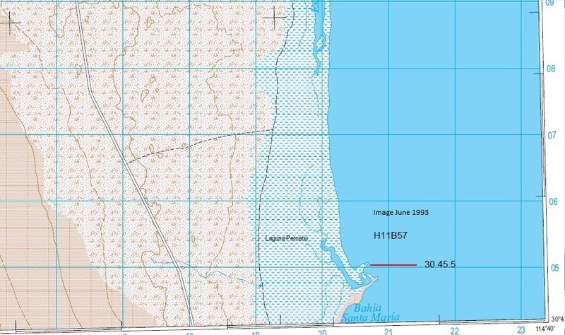
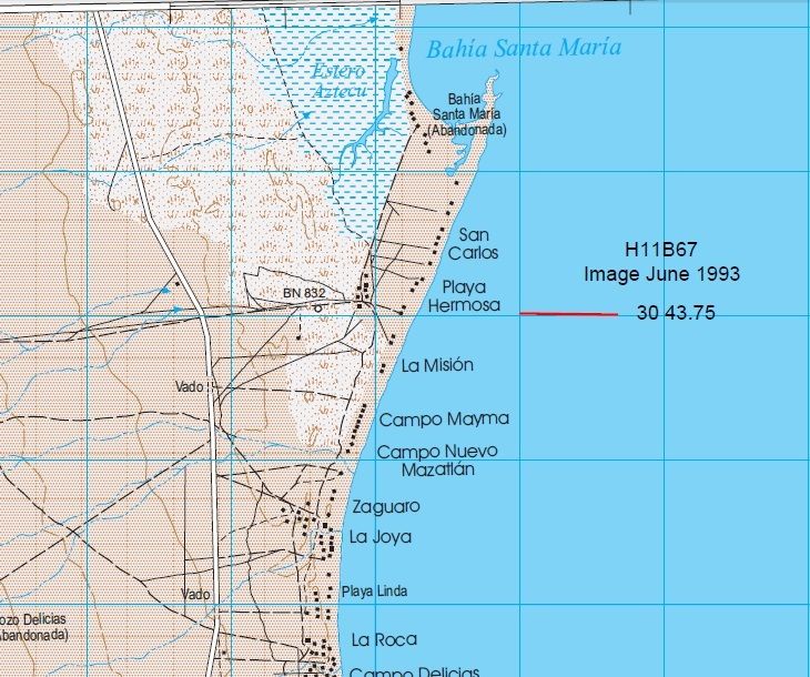
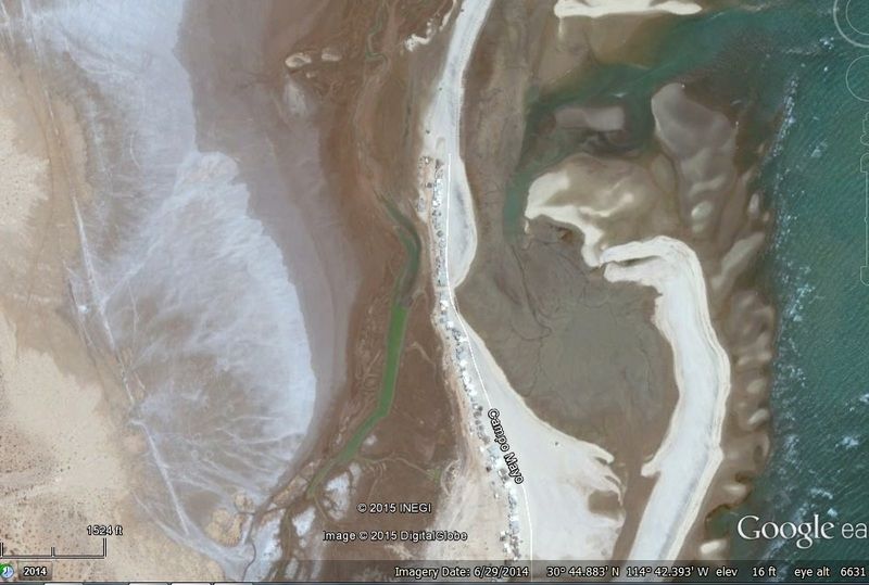
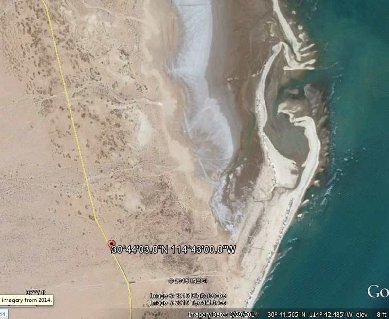
Images
More Shell Island Images
Google Photo 6/29/2014
Inegi Photo dated 1993
[Edited on 5-14-2015 by PaulW]
[Edited on 5-14-2015 by PaulW]
|
|
|
David K
Honored Nomad
Posts: 65565
Registered: 8-30-2002
Location: San Diego County
Member Is Offline
Mood: Have Baja Fever
|
|
Quote: Originally posted by Skipjack Joe  | Read below. 'Shell Island' is not island. It's a barrier spit, part of the beach it's connected. Whatever that beach is called, that's what 'Shell
Island' is named. Since it encloses Percebu Lagoon that's it's true name. Islands are permanently completely bordered by water.
http://www.fws.gov/cbra/Act/Coastal_Barriers.html
Types of Coastal Barrier Landforms
Coastal barrier landforms may be described by their relationships to the mainland as bay barriers, tombolos, barrier spits, and barrier islands.
Additional areas which function as coastal barriers include dune and beach barriers, and fringing mangroves. The term "mainland" includes the
continental land mass as well as large islands such as Long Island, New York and the Hawaiian Islands. Definitions of the various kinds of coastal
barriers follow:
Bay barriers - coastal barriers that connect two headlands, and enclose a pond, marsh, or other aquatic habitat. The terms bay mount bar and bay
bar are synonymous.
Tombolos - sand or gravel beaches which connect one or more offshore islands to each other or to the mainland. The terms connecting bar, tie bar,
and tying bar are synonymous.
Barrier spits - coastal barriers that extend into open water and are attached to the mainland at only one end. They can develop into a bay barrier
if they grow completely across a bay or other aquatic habitat. On the other hand, bay barriers can become spits if an inlet is created.
Barrier islands - coastal barriers completely detached from the mainland. Barrier spits may become barrier islands if their connection to the
mainland is severed by creation of a permanent inlet. The barrier island represents a broad barrier beach, commonly sufficiently
above high tide to have dunes, vegetated zones, and wetland areas.
Dune or beach barriers - broad sandy barrier beaches, with hills or ridges of sand formed by winds, which protect landward aquatic habitats.
Fringing mangroves - bands of mangrove along subtropical or tropical mainland shores in areas of low wave energy. Many of these areas are located
behind coral reefs, which together with the mangroves themselves, provide significant protection for the mainland from storm impact.
|
THANK YOU for the geography!
It's just what I have called the place since the 1970's when I first walked across the water to get to it by foot (from Bahia Santa Maria) and then
later by vehicle (at low tide). It fits and it sounds good and those who have been to it (especially at high tide, when they drove through water to
get to it or off it) agree that it is an island.
Now, if it must be surrounded by water 24/7 to 'qualify' to have the name 'Island' attached, then I suggest you have some work to do here in San Diego
County: Coronado Island, Shelter Island, Harbor Island, Fiesta Island, etc. ALL can be driven to on land or via a short bridge, as was the case for
Shell Island at low tide or before the road to the bridge eroded away (from high tide sea water).
Here is that bridge (with Surfer Jim) in 2004, in a Bob H photo:

Surfer Jim on the (mostly gone) causeway road to Shell Island. Built to provide high tide access in 1984 for a development that never was started. The
concrete culvert/ bridge remains while most of the elevated road bed has eroded away.
Here is that same bridge in 2011, after the high tide dropped, and the causeway across the lagoon that once was at the same height as the bridge:
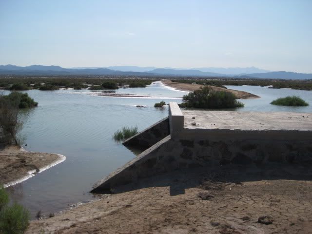
Looking West.
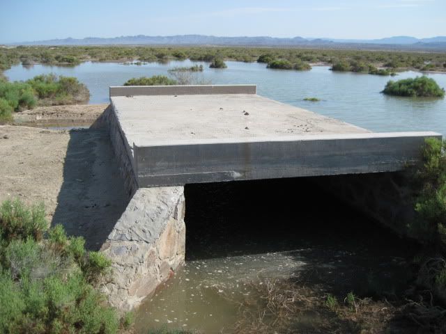
Looking South.
|
|
|
Skipjack Joe
Elite Nomad
Posts: 8092
Registered: 7-12-2004
Location: Bahia Asuncion
Member Is Offline
|
|
Don't tell that to a Italian.
|
|
|
PaulW
Ultra Nomad
Posts: 3113
Registered: 5-21-2013
Member Is Offline
|
|
please note my edit for the photo dates Google is pretty recent.
What do you suppose the history of a causeway and bridge to get to the water side of the dunes?
I further noticed that in 1993 the geographer placed a road paralleling the west side of the estuary and mud flats. I suppose the sea is rising and
the road is overgrown?? Next trip I will search for that road or track.
|
|
|
chuckie
Elite Nomad
Posts: 6082
Registered: 2-20-2012
Location: Kansas Prairies
Member Is Offline
Mood: Weary
|
|
I bet we get some pics of tire tracks before long!
|
|
|
David K
Honored Nomad
Posts: 65565
Registered: 8-30-2002
Location: San Diego County
Member Is Offline
Mood: Have Baja Fever
|
|
| Quote: Originally posted by PaulW | please note my edit for the photo dates Google is pretty recent.
What do you suppose the history of a causeway and bridge to get to the water side of the dunes?
I further noticed that in 1993 the geographer placed a road paralleling the west side of the estuary and mud flats. I suppose the sea is rising and
the road is overgrown?? Next trip I will search for that road or track. |
First saw the elevated road and bridge in 1984. A 1989 map names a campground at the end of the road as El Pelicano. There has never been any
development I have seen and no ruins of any there. 1/4 mile south, at the end of the original road to the island is a commercial fish camp, seasonally
occupied.
The issue I believe is that this is all federal high tide zone, not solid land, and ownership is not possible. Too risky to build on a sand dune
surrounded by water part of the time. Who knows what the future will hold. A marina and golf coarse resort is planned between the bridge and Bahia
Santa Maria!
The road on the west side of the lagoon/ estuary is on the salt flats... other tracks parallel it. The salt flats do go under water at the highest
tides of the year, always have that last 40 years I have gone there... no new change in the sea level has changed this normal condition.
|
|
|
PaulW
Ultra Nomad
Posts: 3113
Registered: 5-21-2013
Member Is Offline
|
|
The resort
Marinazul Golf Resort
Quoting one of the links:
The land on which the mega project is intended to carry out operations is also known as Campo Santa Maria, Ejido Delicias or Percebú and is part of
the Ejido Plan Nacional Agrario located within the municipality of Ensenada.
Actually The general area is as described, but the land was privately owned per Pat Butler.
Pat Butler owned 1,200 hectares that he purchased a long time ago from the ejido and he sold the property to Inveravante the Spanish development
company with many conditions. Butler is getting payments after he does his thing with the Mexicali officials in behalf of Inveravante. The property
has quite a long frontage on the highway where it sports a good looking wall. As was noted the property is north of Santa Maria. I suspect it will
likely include the Campo Mayo lagoon.
www.bajarealestategroup.net/News/Baja_News/Mega-Development_...
http://sanfelipe.com.mx/2013/01/06/only-28-miles-south-from-...
|
|
|
David K
Honored Nomad
Posts: 65565
Registered: 8-30-2002
Location: San Diego County
Member Is Offline
Mood: Have Baja Fever
|
|
Never heard of a Campo Mayo... the lagoon or bay, just south of Shell Island is called 'Bahia Santa Maria', so named about 1969 when it was
established by the Aniceto Madueña Family. Maria was a daughter's name. Before Santa Maria was started, we called that bay, 'The Lagoon', and is where
we went fishing, driving up the beach almost 2 miles from the closest campo, Nuevo Mazatlan, back in the late 60's. Nuevo Mazatlan was previously
known as Agua de Chale.
The Bahia Santa Maria complex was broken into separate camps, Playa Hermosa being the one on the south. The Madueña family no longer owns all the land
they once did.
|
|
|
hayb
Junior Nomad
Posts: 59
Registered: 6-7-2012
Location: Ramona
Member Is Offline
|
|
Skipjack Joe,
Does it really matter whether this is an island or not. My group simply called this place Laguna Percebu for years. The first time I heard David K.
mention as Shell Island, thought it sounded better than Laguna Percebu. As for the Island part, if you have camped there during high tide it does feel
as though you are on an island.
|
|
|
PaulW
Ultra Nomad
Posts: 3113
Registered: 5-21-2013
Member Is Offline
|
|
Shucks - goes to show that the maps and satellite info are not the best resource.
When I drive south down the highway I see signs as follows:
Percebu
Hermosa
La Mision
Santa Maria
Mayma
Mazatian
And the above does not agree with the Almanac which says
Percebu
Santa Maria
Hermosa
San Carlos
Rodriguez
Zaguaro
Mazatlan
La Roca
And the Topo gives another sequence and different names.
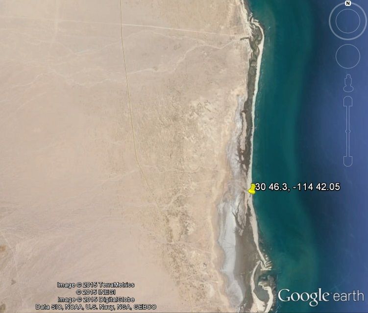
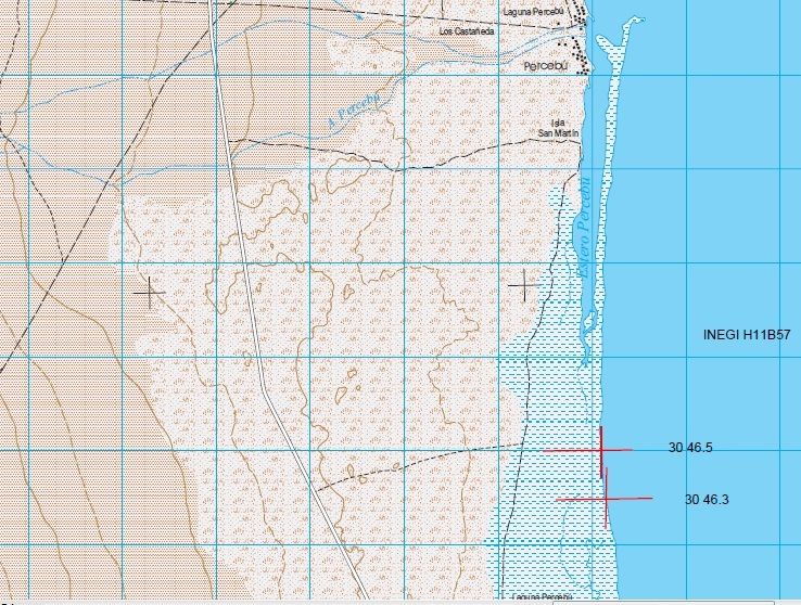
Leaving the Highway at K30.5 (30 44.05, -114 43.) when I look on Google earth I see a road heading north and the label on Google Earth is Campo Mayo
and at its north end is a large lagoon or estuary at 30 44.9, -114 42.). That north road on GE ends 1.1 miles from the left turn after passing many
beach homes.
Anyway here are the images I am looking at. Note the dates of the images. GE is pretty new.
============
| Quote: Originally posted by David K | Never heard of a Campo Mayo... the lagoon or bay, just south of Shell Island is called 'Bahia Santa Maria', so named about 1969 when it was
established by the Aniceto Madueña Family. Maria was a daughter's name. Before Santa Maria was started, we called that bay, 'The Lagoon', and is where
we went fishing, driving up the beach almost 2 miles from the closest campo, Nuevo Mazatlan, back in the late 60's. Nuevo Mazatlan was previously
known as Agua de Chale.
The Bahia Santa Maria complex was broken into separate camps, Playa Hermosa being the one on the south. The Madueña family no longer owns all the land
they once did. |
|
|
|
David K
Honored Nomad
Posts: 65565
Registered: 8-30-2002
Location: San Diego County
Member Is Offline
Mood: Have Baja Fever
|
|
Google Earth is wrong. That is Bahia Santa Maria. We even had a lot there on the bay back in the 70' s.
|
|
|
elgatoloco
Ultra Nomad
Posts: 4355
Registered: 11-19-2002
Location: Yes
Member Is Offline
|
|
No way dude! Get real. Impossible. Your kidding right? 
MAGA
marooons Are Governing America
|
|
|
David K
Honored Nomad
Posts: 65565
Registered: 8-30-2002
Location: San Diego County
Member Is Offline
Mood: Have Baja Fever
|
|
Yet the salt flats that get splashed with sea water only on the highest lunar tides, just inches above the typical high tide line, are STILL just
inches above the typical high tide line, ...50 years later. Why aren't they underwater at every high tide by now, if the sea is rising so much???
|
|
|
mtgoat666
Platinum Nomad
Posts: 21099
Registered: 9-16-2006
Location: San Diego
Member Is Offline
Mood: Hot n spicy
|
|
| Quote: Originally posted by David K | | Yet the salt flats that get splashed with sea water only on the highest lunar tides, just inches above the typical high tide line, are STILL just
inches above the typical high tide line, ...50 years later. Why aren't they underwater at every high tide by now, if the sea is rising so much???
|
the "salt flats" you refer to are probably more properly called a "salt marsh." Sea level has risen several inches in the past few decades, regional
and global survey data show this to be TRUE. You won't see this sea level change dramatically change the frequency of flooding of salt marsh due to
your infrequent visits and because the salt marsh is a depositional environment. Sediment is deposited in the salt marsh area during storm events
(sediment transported in during storm water flows) and by strong winds. The dunes you see at the beach are indicative of the ability of winds to move
sediment. None of the ground surface in a sand spit and back marsh are static, the sediment is moving around during storm events - and the surface
elevation goes up and down as mother nature moves the sediment around.
the area is also tectonically active, there may be regional uplift or sinking occuring at rate on same order as sea level change (though the tectonic
elevation changes are probably much less than sea level change).
that's why!
|
|
|
rts551
Elite Nomad
Posts: 6700
Registered: 9-5-2003
Member Is Offline
|
|
| Quote: Originally posted by David K | | Yet the salt flats that get splashed with sea water only on the highest lunar tides, just inches above the typical high tide line, are STILL just
inches above the typical high tide line, ...50 years later. Why aren't they underwater at every high tide by now, if the sea is rising so much???
|
How many times do people have to show you the real facts.
http://oceanservice.noaa.gov/facts/sealevel.html
|
|
|
David K
Honored Nomad
Posts: 65565
Registered: 8-30-2002
Location: San Diego County
Member Is Offline
Mood: Have Baja Fever
|
|
How is it that you cannot believe your own eyes?
|
|
|
mtgoat666
Platinum Nomad
Posts: 21099
Registered: 9-16-2006
Location: San Diego
Member Is Offline
Mood: Hot n spicy
|
|
dk: if you are doing carpentry, do you use a tape measure to measure before you cut or do you just eyeball it? sometimes measurements are more
reliable than WAGs.
|
|
|
| Pages:
1
2
3
4
5 |


