| Pages:
1
2
3
4
5
6
7 |
David K
Honored Nomad
        
Posts: 65437
Registered: 8-30-2002
Location: San Diego County
Member Is Offline
Mood: Have Baja Fever
|
|
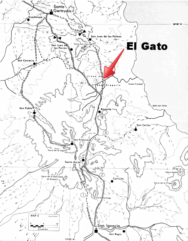
El Gato is located where the road to La Trinidad intersects with El Camino Real, east branch or the Golfo Camino Real.
|
|
|
rich t
Nomad
 
Posts: 102
Registered: 4-18-2016
Member Is Offline
|
|
Route
Has anyone been on any of the three routes shown on David K's map from Santa Gertrudis to San Ignacio? Wanted to scout out another route going from
San Fransquito, Santa Barbara Ranch to San Ignacio, this will be a bike trip in March 2018, will scout it out in my Jeep probably in January.
|
|
|
mtgoat666
Platinum Nomad
       
Posts: 20564
Registered: 9-16-2006
Location: San Diego
Member Is Offline
Mood: Hot n spicy
|
|
Quote: Originally posted by rich t  | | Has anyone been on any of the three routes shown on David K's map from Santa Gertrudis to San Ignacio? Wanted to scout out another route going from
San Fransquito, Santa Barbara Ranch to San Ignacio, this will be a bike trip in March 2018, will scout it out in my Jeep probably in January.
|
The map scale makes it hard to see what route is. But that is mostly protected area, you can’t enter w/o guide, and motorcycles are generally
verboten. If you want to travel up there, it’s w/ guides, and usually traveling by foot/mule.
A really great place to travel, well worth the adventure of giving up internal combustion engines for a few days!
Woke!
Hands off!
“Por el bien de todos, primero los pobres.”
“...ask not what your country can do for you – ask what you can do for your country.” “My fellow citizens of the world: ask not what America
will do for you, but what together we can do for the freedom of man.”
Pronoun: the royal we
|
|
|
rich t
Nomad
 
Posts: 102
Registered: 4-18-2016
Member Is Offline
|
|
The route I am most interested in is the eastern one from Santa Gertrudis which crosses the entrance to El Gato, we can take the road south from
there, have done that several times, but have never been from Santa Gertrudis to El gato, is that a 2 track?
|
|
|
Desertbull
Senior Nomad
  
Posts: 558
Registered: 8-27-2003
Member Is Offline
|
|
drove thru a couple weeks ago the entire No Wimps ... a tractor / grader has cleaned it all up ... a new side road thru El Gato bypasses all the
crappy rock trail ... it was less then a full day from San Ignacio to Punta San Fransiquito ... good times.
[Edited on 11-7-2017 by Desertbull]
DREAM IT! PLAN IT! LIVE IT!
|
|
|
rich t
Nomad
 
Posts: 102
Registered: 4-18-2016
Member Is Offline
|
|
Thanks for the info, last year there was talk about someone buying a large parcel of property and putting up a gate and blocking El Gato, sounds like
it never happened.
|
|
|
David K
Honored Nomad
        
Posts: 65437
Registered: 8-30-2002
Location: San Diego County
Member Is Offline
Mood: Have Baja Fever
|
|
Quote: Originally posted by rich t  | | Has anyone been on any of the three routes shown on David K's map from Santa Gertrudis to San Ignacio? Wanted to scout out another route going from
San Fransquito, Santa Barbara Ranch to San Ignacio, this will be a bike trip in March 2018, will scout it out in my Jeep probably in January.
|
This lady (and others riding mules):

|
|
|
David K
Honored Nomad
        
Posts: 65437
Registered: 8-30-2002
Location: San Diego County
Member Is Offline
Mood: Have Baja Fever
|
|
Quote: Originally posted by Desertbull  | drove thru a couple weeks ago the entire No Wimps ... a tractor / grader has cleaned it all up ... a new side road thru El Gato bypasses all the
crappy rock trail ... it was less then a full day from San Ignacio to Punta San Fransiquito ... good times.
[Edited on 11-7-2017 by Desertbull] |
Interesting news Tim!
Word is a power cable will cross the gulf near El Barril and connect with the Baja Sur power grid near Santa Rosalia. Perhaps this grading is for that
project? Can you draw us a map showing the new graded road in relation to the No Wimps Trail?
Thank you.
|
|
|
TMW
Select Nomad
      
Posts: 10659
Registered: 9-1-2003
Location: Bakersfield, CA
Member Is Offline
|
|
Fencing has already started to be installed with gates. Whether the gates will be locked or not is not clear at this time. The person in charge has
not made it clear in his communications. The person in charge is named Juan and he is working out of Rancho La Ilusion near El Barril. This is for a
mountain goat preserve. I'm not sure of the total area involved. I was told it covered the Rancho Santa Barbara and Rancho San Miguel areas.
If anyone stops at Rancho La Ilusion they may be able to talk to Juan and get the latest info.
Harald, Nomad 4x4abc, may have more info on the power line going thru that David mentioned. He had a map of the basic route.
|
|
|
TMW
Select Nomad
      
Posts: 10659
Registered: 9-1-2003
Location: Bakersfield, CA
Member Is Offline
|
|
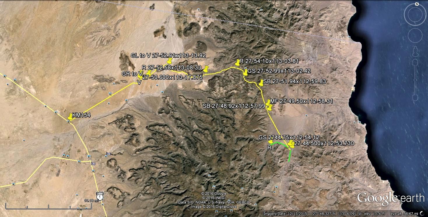
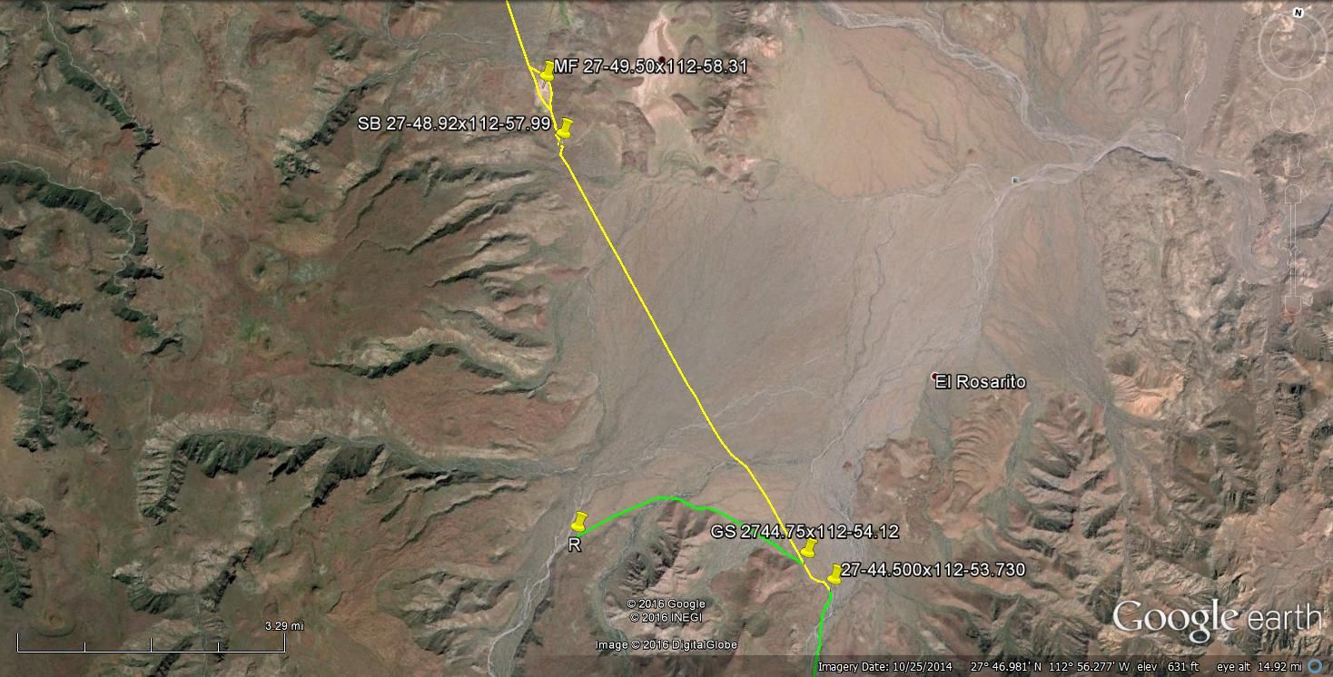
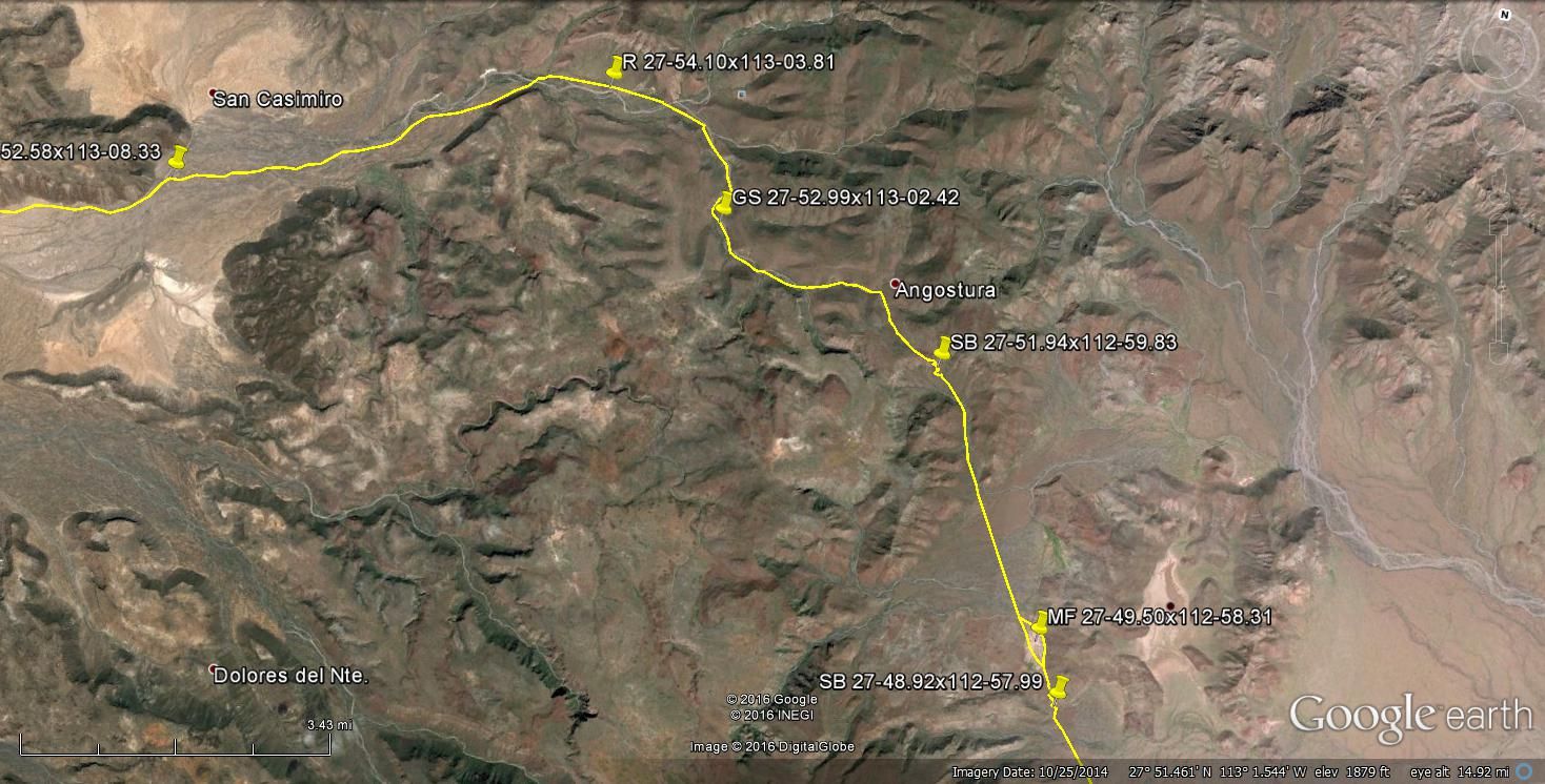
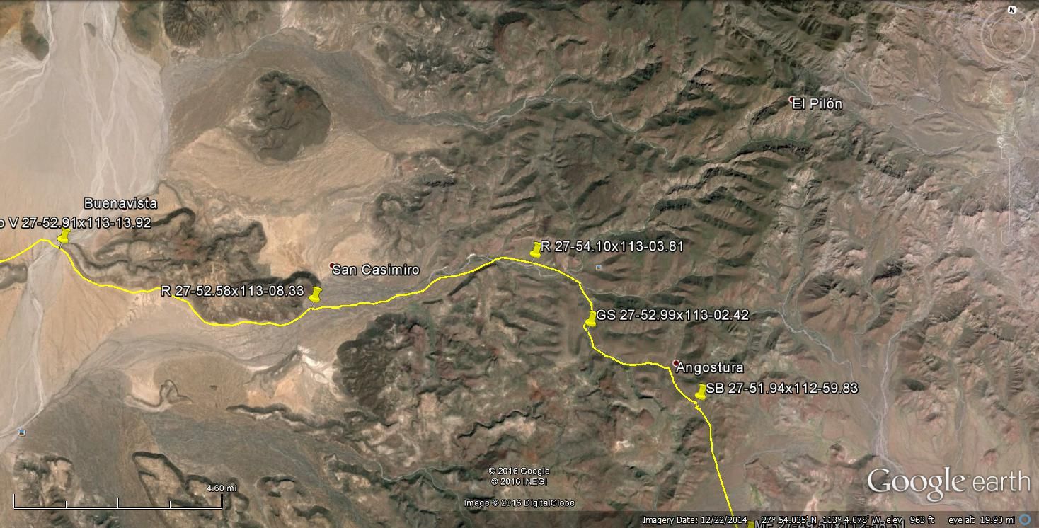
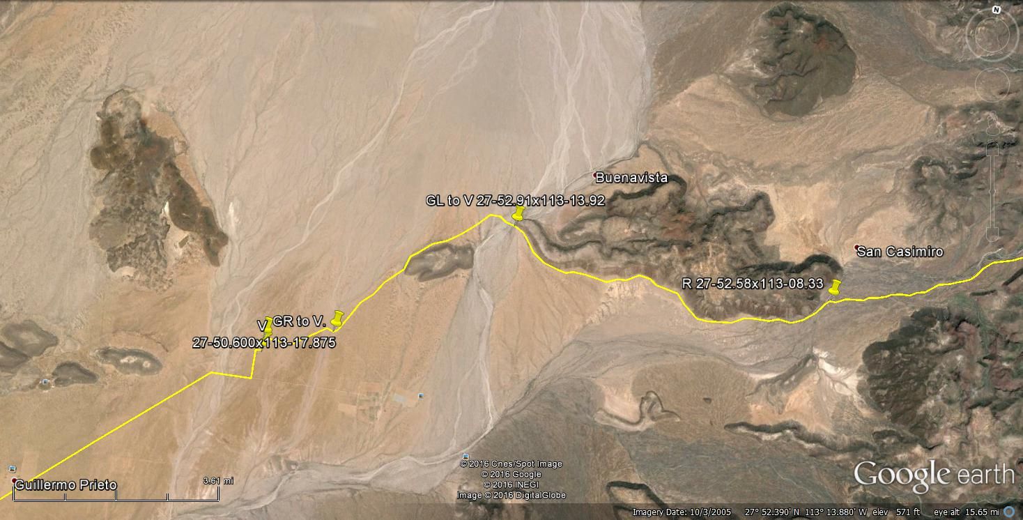
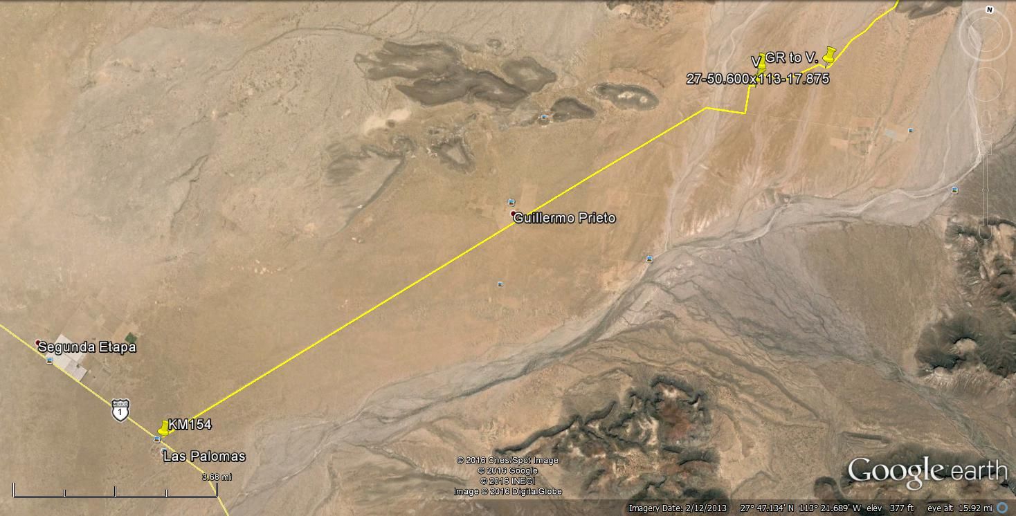
I traced a route about 5 miles south of El Gato going northwest toward Santa Gertrudis but topping off before the 28th parallel rounding down to Hwy 1
at KM154. It looked to be all two track with a couple of ranches along the way.
|
|
|
David K
Honored Nomad
        
Posts: 65437
Registered: 8-30-2002
Location: San Diego County
Member Is Offline
Mood: Have Baja Fever
|
|
You saying a 4 wheel vehicle can get from San Casimiro over the sierra to Santa Marta/ El Rosarito now? wow!
|
|
|
rich t
Nomad
 
Posts: 102
Registered: 4-18-2016
Member Is Offline
|
|
TMW, did you actually run this or pick the roads up on google earth?
|
|
|
4x4abc
Ultra Nomad
    
Posts: 4454
Registered: 4-24-2009
Location: La Paz, BCS
Member Is Offline
Mood: happy - always
|
|
not drivable with 4x4, Tom
maybe, maybe, maybe with a bike
I am pretty sure that when CFE is done with the new power line, the area will be closed off
the new power line (230kV) will run from a tad south of San Francisquito to Santa Rosalia along the coastline
good bye No Wimp trail
Harald Pietschmann
|
|
|
rich t
Nomad
 
Posts: 102
Registered: 4-18-2016
Member Is Offline
|
|
Can you go from Santa Barbara Ranch, Santa Gertrudis, San Casimino, to El Trufino which ties into the No Wimps just west of El Gato?
|
|
|
TMW
Select Nomad
      
Posts: 10659
Registered: 9-1-2003
Location: Bakersfield, CA
Member Is Offline
|
|
I followed it on Google Earth. The GE map was 2014 so the storms from then may have made it impossible to run now.
|
|
|
TMW
Select Nomad
      
Posts: 10659
Registered: 9-1-2003
Location: Bakersfield, CA
Member Is Offline
|
|
I don't think you can go from Santa Gertrudis to Rancho Santa Barbara except maybe on a motorcycle. At least that is the way it looks on Google Earth.
There is a section closer to Santa Barbara that you lose the trail on GE.
|
|
|
rich t
Nomad
 
Posts: 102
Registered: 4-18-2016
Member Is Offline
|
|
Has anyone tried going from San Francisquito, Rancho Piedra Blanca, Rancho Miraflores, Santa Gertrudis, San Casimino then to El trufino?
|
|
|
David K
Honored Nomad
        
Posts: 65437
Registered: 8-30-2002
Location: San Diego County
Member Is Offline
Mood: Have Baja Fever
|
|
Quote: Originally posted by TMW  | | I don't think you can go from Santa Gertrudis to Rancho Santa Barbara except maybe on a motorcycle. At least that is the way it looks on Google Earth.
There is a section closer to Santa Barbara that you lose the trail on GE. |
Santa Gertrudis to Santa Barbara and on to the coast was a mission supply trail.
It was done on m/c about 15 years ago by Kevin Ward. No 4x4s. Pretty crazy cliff the mission era trail drops down along.
|
|
|
rich t
Nomad
 
Posts: 102
Registered: 4-18-2016
Member Is Offline
|
|
How about the route above your last post, do you know if it is doable David?
|
|
|
David K
Honored Nomad
        
Posts: 65437
Registered: 8-30-2002
Location: San Diego County
Member Is Offline
Mood: Have Baja Fever
|
|
Show me El Trufino on a map and I will check my sources. From what I saw near Prosperidad a few months ago, I bet fences are going to be an issue.
|
|
|
| Pages:
1
2
3
4
5
6
7 |

