| Pages:
1
2
3
4
5 |
David K
Honored Nomad
        
Posts: 65436
Registered: 8-30-2002
Location: San Diego County
Member Is Offline
Mood: Have Baja Fever
|
|
Sunday Night Messages 11-10-19 & Monday Morning 11-11-19
6:17 PM:
Device Name: grahamspot
GPS location Date/Time: 11/10/2019 18:17:45 PST
The message sender did not share their GPS location with you.
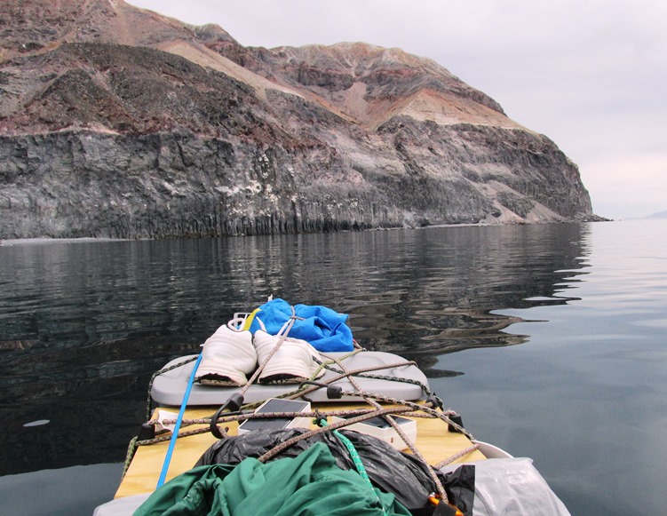
Message: Great to round cliffs of Punta Los Machos. If still calm Monday will try to reach Este Ton and return to where I started. 9 hrs paddling hoy
6:26 PM:
Device Name: grahamspot
GPS location Date/Time: 11/10/2019 18:26:07 PST
The message sender did not share their GPS location with you.
Message: After long paddle and making camp, still had to get out and make quart of water. Looking forward to my first beer. Been "Marooned" with none
Monday 6:09 AM:
Device Name: grahamspot
Latitude: 29.25184
Longitude: -113.42697
Altitude: -1.0 m | -3 ft
GPS location Date/Time: 11/11/2019 06:09:10 PST
Message: Check-in/OK. All's well. No problems.
Click the link below to see where I am located.
http://fms.ws/1ELqAB/29.25184N/113.42697W
6:29 AM:
Device Name: grahamspot
Latitude: 29.25184
Longitude: -113.42697
GPS location Date/Time: 11/11/2019 06:26:55 PST
Message: change of plans. Staying here a while. Woke at 1am big surf running up beach. Had to move tent. West wind? But not here. No to night surf go
Click the link below to see where I am located.
http://fms.ws/1ELs4B/29.25184N/113.42697W
|
|
|
David K
Honored Nomad
        
Posts: 65436
Registered: 8-30-2002
Location: San Diego County
Member Is Offline
Mood: Have Baja Fever
|
|
Monday 11-11-19
10:21 AM:
Device Name: grahamspot
Latitude: 29.23900
Longitude: -113.42825
Altitude: -1.0 m | -3 ft
GPS location Date/Time: 11/11/2019 10:21:53 PST
Message: Check-in/OK. All's well. No problems.
Click the link below to see where I am located.
http://fms.ws/1EMFzy/29.23900N/113.42825W
|
|
|
David K
Honored Nomad
        
Posts: 65436
Registered: 8-30-2002
Location: San Diego County
Member Is Offline
Mood: Have Baja Fever
|
|
At 1:37 pm, Graham was back at Este Ton.
[Edited on 11-12-2019 by David K]

|
|
|
David K
Honored Nomad
        
Posts: 65436
Registered: 8-30-2002
Location: San Diego County
Member Is Offline
Mood: Have Baja Fever
|
|
Monday Messages 11-11-19
6:47 PM:
Device Name: grahamspot
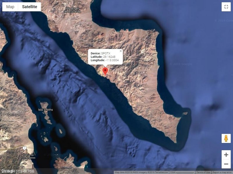
Latitude: 29.16227
Longitude: -113.33027
GPS location Date/Time: 11/11/2019 18:47:21 PST
Message: Thanks for sharing David and for weather forecast. Was unsure I could safely get out and pump water so ran for ET with pm tide. Flat inside.
Click the link below to see where I am located.
http://fms.ws/1EN3iP/29.16227N/113.33027W
6:54 PM:
Device Name: grahamspot
GPS location Date/Time: 11/11/2019 18:54:18 PST
The message sender did not share their GPS location with you.
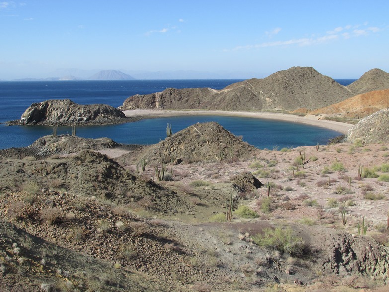
Message: Lovely island. So rugged and beautiful. All good. This cove is so sheltered. Divers camped here. Traded some snacks for gal of water.
|
|
|
David K
Honored Nomad
        
Posts: 65436
Registered: 8-30-2002
Location: San Diego County
Member Is Offline
Mood: Have Baja Fever
|
|
Tuesday 11-12-19
7:47 AM:
Device Name: grahamspot
Latitude: 29.16268
Longitude: -113.33032
Altitude: -1.0 m | -3 ft
GPS location Date/Time: 11/12/2019 07:47:51 PST
Message: Check-in/OK. All's well. No problems.
Click the link below to see where I am located.
http://fms.ws/1EO2S4/29.16268N/113.33032W
|
|
|
David K
Honored Nomad
        
Posts: 65436
Registered: 8-30-2002
Location: San Diego County
Member Is Offline
Mood: Have Baja Fever
|
|
TUE Messages
1:30 PM:
Device Name: grahamspot
Latitude: 29.16194
Longitude: -113.33004
GPS location Date/Time: 11/12/2019 13:30:04 PST
Message: Glad not paddling today. Much windier. Panguero friends left back to mainland. Enjoying peace of bay. If conditions allow back in Bahia Weds
Click the link below to see where I am located.
http://fms.ws/1EOi_Q/29.16194N/113.33004W
3:37 PM:
Device Name: grahamspot
Latitude: 29.16248
Longitude: -113.33035
Altitude: -7.0 m | -23 ft
GPS location Date/Time: 11/12/2019 15:37:33 PST
Message: Check-in/OK. All's well. No problems.
Click the link below to see where I am located.
http://fms.ws/1EOxMy/29.16248N/113.33035W
6:15 PM:
Device Name: grahamspot
GPS location Date/Time: 11/12/2019 17:59:15 PST
The message sender did not share their GPS location with you.
Message: Saw weird lights in sky last evening - like string of pearls. Que es? So lovely and magical cove. Fitting to end here. Thx for great wind fc
>>> I sent Graham a wind forecast for the next 5 days from this page: https://www.windfinder.com/forecast/bahia-de-los-angeles
|
|
|
David K
Honored Nomad
        
Posts: 65436
Registered: 8-30-2002
Location: San Diego County
Member Is Offline
Mood: Have Baja Fever
|
|
What Graham saw (and so did Shari):
Those bright lights marching slowly in a straight line across the sky this week aren't comets or meteors -- although there was also this bright meteor
-- but the second batch of SpaceX Starlink broadband satellites.
Elon Musk's space company launched 60 of the small internet routers aboard a Falcon 9 rocket Monday and within hours they were being spotted around
the world, flying in formation. The sight looks like a train of staggered lights or bright stars, moving in a straight line through space.
Spotters from California to Maryland to Japan uploaded video evidence of the odd spectacle, which again raised concerns from astronomers.
SpaceX launched its first flock of 60 Starlink birds in May, and a number of scientists sounded the alarm that the company's plans to launch thousands
of the reflective objects could have an adverse effect on astronomical observations.
It soon became clear the satellites become much less visible as they gain altitude and orient themselves for operation. SpaceX has pledged to
coordinate with astronomers to minimize impacts and also paint the satellites to make them less reflective, although the batch that went up Monday was
unpainted like the first group.
However, since the May launch, SpaceX has made its full ambitions more clear through regulatory filings that seek to launch up to 42,000 of the
satellites in coming years. And SpaceX is just one of a handful of companies looking to launch such mega-constellations.
|
|
|
David K
Honored Nomad
        
Posts: 65436
Registered: 8-30-2002
Location: San Diego County
Member Is Offline
Mood: Have Baja Fever
|
|
7:40 PM TUE
Device Name: grahamspot
GPS location Date/Time: 11/12/2019 19:40:55 PST
The message sender did not share their GPS location with you.
Message: Moon so bright. Lovely island no coyotes just feral cats and crazy ravens. Expect to be picked up tomorrow morn if not abducted by aliens.
|
|
|
David K
Honored Nomad
        
Posts: 65436
Registered: 8-30-2002
Location: San Diego County
Member Is Offline
Mood: Have Baja Fever
|
|
Back on the peninsula! L.A. Bay. Wed. 11-13-19
Device Name: grahamspot
Latitude: 28.93564
Longitude: -113.55048
Altitude: 2.0 m | 7 ft
GPS location Date/Time: 11/13/2019 11:35:01 PST
Message: Check-in/OK. All's well. No problems.
Click the link below to see where I am located.
http://fms.ws/1EQeqg/28.93564N/113.55048W
|
|
|
JZ
Select Nomad
      
Posts: 13939
Registered: 10-3-2003
Member Is Offline
|
|
Refugio is really, really spectacular. Top 5 spot in all of Baja for me.
|
|
|
chuckie
Elite Nomad
     
Posts: 6082
Registered: 2-20-2012
Location: Kansas Prairies
Member Is Offline
Mood: Weary
|
|
Graham is a really great guy....Been around him a few times,read and own his books....If JZ says its on his top5 list,I am sorry I missed it, in my
30+yearsin Baja....thanks, Graham, DK,and JZ...
|
|
|
chuckie
Elite Nomad
     
Posts: 6082
Registered: 2-20-2012
Location: Kansas Prairies
Member Is Offline
Mood: Weary
|
|
Glad you approve!
|
|
|
Graham
Senior Nomad
  
Posts: 558
Registered: 6-16-2006
Location: San Diego and DeTour, MI
Member Is Offline
|
|
Trip over... but would love to return to that beautiful island. Thanks everyone for following and special thanks to David K for posting and sending me
weather information. A great aspect of having 2-way communication. Hard to conceive that at over 40 miles long there is no permanent settlement on the
island. Most days I didn't see anyone. Puerto Refugio is indeed spectacular but was amazed no one was there. The few pangueros I met were all from the
mainland... night diving for sea cucumbers and whatever else they could take. When I returned to Este Ton was glad to pick up water from them. Saved
me from desalinating water after hours paddling the kayak.
 
|
|
|
Pacifico
Super Nomad
   
Posts: 1299
Registered: 5-26-2008
Member Is Offline
|
|
Wow! What a great trip, Graham! Thanks for letting us follow along...
"Plan your life as if you are going to live forever. Live your life as if you are going to die tomorrow." - Carlos Fiesta
|
|
|
JZ
Select Nomad
      
Posts: 13939
Registered: 10-3-2003
Member Is Offline
|
|
Surprising that the maps on the Spot site are so lacking in detail when you zoom in tight. You'd think a better map source would be available.
|
|
|
AKgringo
Elite Nomad
     
Posts: 6308
Registered: 9-20-2014
Location: Anchorage, AK (no mas!)
Member Is Offline
Mood: Retireded
|
|
Using the link Graham posted, I zoomed in on my house in CA. It is the exact result I get using Google Map!
If you are not living on the edge, you are taking up too much space!
"Could do better if he tried!" Report card comments from most of my grade school teachers. Sadly, still true!
|
|
|
mtgoat666
Platinum Nomad
       
Posts: 20555
Registered: 9-16-2006
Location: San Diego
Member Is Offline
Mood: Hot n spicy
|
|
Quote: Originally posted by JZ  | Surprising that the maps on the Spot site are so lacking in detail when you zoom in tight. You'd think a better map source would be available.
|
Clicking graham’s links to spot website i am seeing google sat photos and google topo based on inegi topo. I doubt there is a more detailed map on
the market than inegi 50k topo.
What better map source are you expecting?
Woke!
Hands off!
“Por el bien de todos, primero los pobres.”
“...ask not what your country can do for you – ask what you can do for your country.” “My fellow citizens of the world: ask not what America
will do for you, but what together we can do for the freedom of man.”
Pronoun: the royal we
|
|
|
JZ
Select Nomad
      
Posts: 13939
Registered: 10-3-2003
Member Is Offline
|
|
I missed the satellite option. The topo isn't very details.
|
|
|
David K
Honored Nomad
        
Posts: 65436
Registered: 8-30-2002
Location: San Diego County
Member Is Offline
Mood: Have Baja Fever
|
|
When you go to the Spot location link, in the top left corner it says: MAP (or) SATELLITE. Just click on Satellite and zoom in.
Graham has more photos than the two he posted above. Graham or I will add them soon... Very cool photos!
|
|
|
Skipjack Joe
Elite Nomad
     
Posts: 8091
Registered: 7-12-2004
Location: Bahia Asuncion
Member Is Offline
|
|
Graham,
How did the water taste that was generated by the katadyn desalinator you used? Did it taste like spring water or was it just tolerable?
How difficult was it to pump the water? Did it require a fair amount of strength and did it take a long time to generate say one liter of water. I
found some you tube videos on it's usage but would appreciate your own practical report.
Thanks
|
|
|
| Pages:
1
2
3
4
5 |

