| Pages:
1
2
3
4
5 |
4x4abc
Ultra Nomad
    
Posts: 4454
Registered: 4-24-2009
Location: La Paz, BCS
Member Is Offline
Mood: happy - always
|
|
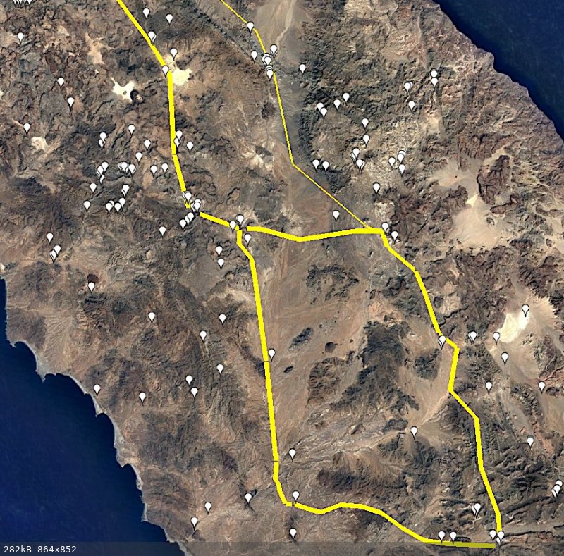
all known water sources in the area
Harald Pietschmann
|
|
|
David K
Honored Nomad
        
Posts: 65436
Registered: 8-30-2002
Location: San Diego County
Member Is Online
Mood: Have Baja Fever
|
|
Interesting water source data base, Harald. What is the source of your intel on them?
|
|
|
John Harper
Super Nomad
   
Posts: 2289
Registered: 3-9-2017
Location: SoCal
Member Is Offline
|
|
Yes, that's pretty amazing how many sources. I assume many are non-potable, mineral springs?
John
|
|
|
4x4abc
Ultra Nomad
    
Posts: 4454
Registered: 4-24-2009
Location: La Paz, BCS
Member Is Offline
Mood: happy - always
|
|
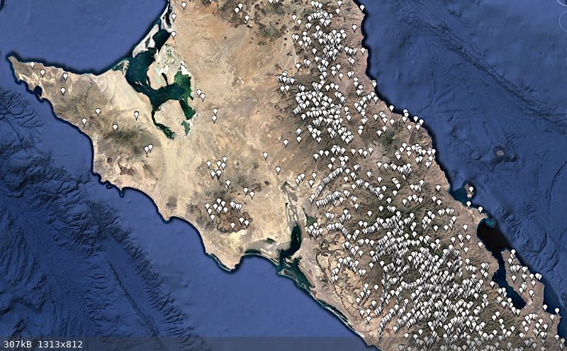
a good number is sweet and in reach
most are good water but tucked away
many are inconsistent
some will help you survive but are not pleasant
I created the data for the water sources
the majority is from sat images
Baja actually has a lot of water sources
but as the Jesuits already noticed, they are rarely in places where you could use the water
Harald Pietschmann
|
|
|
David K
Honored Nomad
        
Posts: 65436
Registered: 8-30-2002
Location: San Diego County
Member Is Online
Mood: Have Baja Fever
|
|
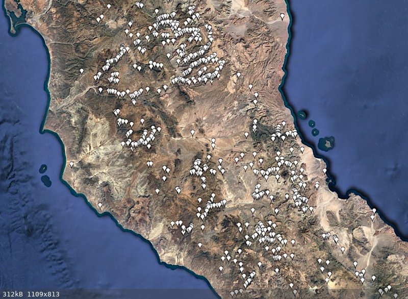
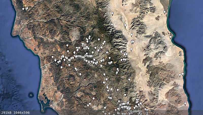
Can you show us the San Felipe to Laguna Chapala region sources?
|
|
|
4x4abc
Ultra Nomad
    
Posts: 4454
Registered: 4-24-2009
Location: La Paz, BCS
Member Is Offline
Mood: happy - always
|
|
still working on San Pedro Martir
but this is what I have so far
Harald Pietschmann
|
|
|
4x4abc
Ultra Nomad
    
Posts: 4454
Registered: 4-24-2009
Location: La Paz, BCS
Member Is Offline
Mood: happy - always
|
|
.
Harald Pietschmann
|
|
|
John Harper
Super Nomad
   
Posts: 2289
Registered: 3-9-2017
Location: SoCal
Member Is Offline
|
|
Wow, that's incredible.
John
|
|
|
David K
Honored Nomad
        
Posts: 65436
Registered: 8-30-2002
Location: San Diego County
Member Is Online
Mood: Have Baja Fever
|
|
Please add the area from Matomí to Chapala, if you can.
I guess the marker north of Matomí is Nuevo Mazatlan (Agua de Chale well), but what is the other one just west?
|
|
|
4x4abc
Ultra Nomad
    
Posts: 4454
Registered: 4-24-2009
Location: La Paz, BCS
Member Is Offline
Mood: happy - always
|
|
image above San Felipe area
Harald Pietschmann
|
|
|
Don Jorge
Senior Nomad
  
Posts: 676
Registered: 8-29-2003
Member Is Offline
|
|
Quote: Originally posted by 4x4abc  | a good number is sweet and in reach
most are good water but tucked away
many are inconsistent
some will help you survive but are not pleasant
I created the data for the water sources
the majority is from sat images
Baja actually has a lot of water sources
but as the Jesuits already noticed, they are rarely in places where you could use the water |
Wow! That is so interesting and absolutely one of the best "maps" ever shared here! Thanks for both taking the time to collect the data and share
it.
�And it never failed that during the dry years the people forgot about the rich years, and during the wet years they lost all memory of the dry
years. It was always that way.�― John Steinbeck
"Until a person learns to respect nature and talk to the animal world, he will never know his true role on Earth." Enzo Mallorca
"Nature bats last." Doug "Hayduke" Peac-ck
|
|
|
4x4abc
Ultra Nomad
    
Posts: 4454
Registered: 4-24-2009
Location: La Paz, BCS
Member Is Offline
Mood: happy - always
|
|
working on this project for many years
now looking for a way to make it available to people who need all the exotic stuff i have recorded
can't be open source (gpx or kmz) - need to buy food and beer sometimes
I have everything anyone would ever need
property markers
rodeo
horse races
ship wrecks
railroads & tramways
pilas
beautiful spots
beaches
bays
Puntas
ruins
lighthouses
chapels
memorials/graves
missions
toll booths
hot springs
cementerios
mountains
lomas
sierras
llanos
lagunas
esteros
dunes
settlements
bridges
MC trails
MTB trails
whale watch locations
ranchos
corrales
springs
canyons
arroyos
palmas
cell towers
old map places
all topo sheet numbers
cuestas
piers
volcanos
US war installations
RV places
gas stations
LPG stations
e-charge stations
some bars
some hotels
air signs
airstrips
airports
mid air airplanes
some ATM
Mexican Flags
water treatment plants
solar plants
jesuit cal activities
benchmarks
campos touristicos
checkpoints
gates
CFE installations
gringo developments
fish camps
fields
ghost towns
missonary grape locations
islands
indian stuff
cave paintings
lagunas
km markers
mesas
mines
mission stuff
water works
dams
mysterious stuff
points of interest
prisons
propane
puertos
ruins
salinas
saltos
ship wrecks
slot canyons
structures
trash sites
valles
walls fences
fairy circles
historic 1970's
ranchos
airplane wrecks
casonas
chimneys
geoglyphs
mangroves
miradores
monuments
fish farms
shrimp farms
all roads
all 4x4 tracks
all mining trails
animal tracks
Camino Real
Pemex exploration tracks
Harald Pietschmann
|
|
|
4x4abc
Ultra Nomad
    
Posts: 4454
Registered: 4-24-2009
Location: La Paz, BCS
Member Is Offline
Mood: happy - always
|
|
the beauty of this digital almanac is that everything is searchable (unlike the print/pdf versions)
you can add/remove any group from your display
searching for cemeteries in the El Triunfo-San Antonio area?
go to El Triunfo
select cemeteries
gives you location, name, size, orientation, possible comments
looking for the real Camino Real (not some scribble on a 1:100,000 map)?
I have it recorded
like the one between Londo/El Rosarito and Mulege
the original 1705 route
Harald Pietschmann
|
|
|
Don Pisto
Banned
Posts: 1282
Registered: 8-1-2018
Location: El Pescador
Member Is Offline
Mood: weary like everyone else
|
|
Quote: Originally posted by 4x4abc  | the beauty of this digital almanac is that everything is searchable (unlike the print/pdf versions)
you can add/remove any group from your display
searching for cemeteries in the El Triunfo-San Antonio area?
go to El Triunfo
select cemeteries
gives you location, name, size, orientation, possible comments
looking for the real Camino Real (not some scribble on a 1:100,000 map)?
I have it recorded
like the one between Londo/El Rosarito and Mulege
the original 1705 route
|
"I created the data for the water sources
the majority is from sat images".......I don't understand how does a satellite image know there's water there?
there's only two things in life but I forget what they are........
John Hiatt
|
|
|
John Harper
Super Nomad
   
Posts: 2289
Registered: 3-9-2017
Location: SoCal
Member Is Offline
|
|
This is an amazing amount of work done by 4x4. Very impressive. Thank you so much for your efforts. I may never use it, but I sure appreciate the
work involved to produce it.
John
|
|
|
4x4abc
Ultra Nomad
    
Posts: 4454
Registered: 4-24-2009
Location: La Paz, BCS
Member Is Offline
Mood: happy - always
|
|
how do you spot water on sat images?
ocean is easy - right?
due to space reflection it almost always shows as black
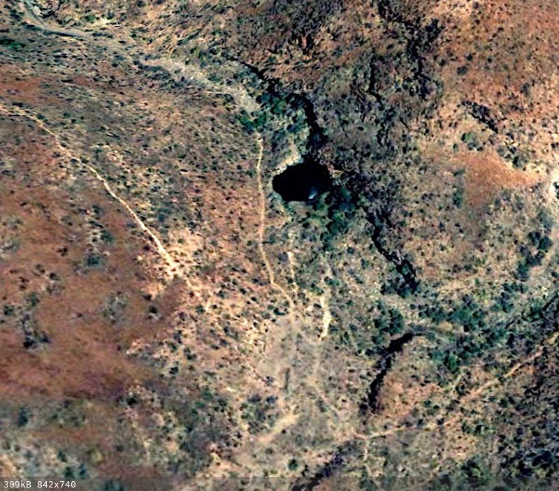
Aguajes, Pozas, Tinajas are a bit more difficult to find
they are always in a canyon
they have animal tracks going to and from if the water is drinkable
like the Tinaja below
it is 90 ft in diameter
it shows strong trails
it has some human activity close (Corral)
you won't find it on any map
it is not mentioned anywhere
Harald Pietschmann
|
|
|
4x4abc
Ultra Nomad
    
Posts: 4454
Registered: 4-24-2009
Location: La Paz, BCS
Member Is Offline
Mood: happy - always
|
|
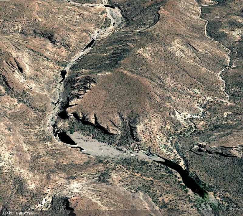
another example
Arroyo La Palmilla (close to San Evaristo)
Aguajes (large Tinajas) show in black
the historical images in Google Earth allow an evaluation whether the water is temporary or permanent
Harald Pietschmann
|
|
|
4x4abc
Ultra Nomad
    
Posts: 4454
Registered: 4-24-2009
Location: La Paz, BCS
Member Is Offline
Mood: happy - always
|
|
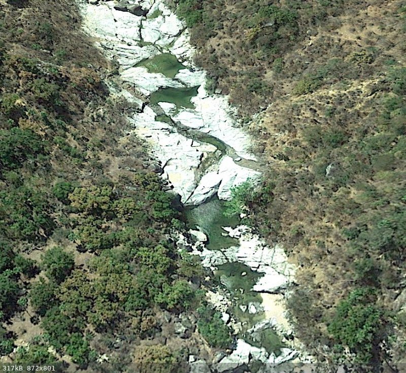
thanks to the hyper building activities in BCS the sat images are almost photo realistic
there is no way to mistake water for something else
below Arroyo Agua Caliente close to Santiago
unfortunately images on Nomad are always blurry
go see the real thing in Google Earth
stunning
Harald Pietschmann
|
|
|
4x4abc
Ultra Nomad
    
Posts: 4454
Registered: 4-24-2009
Location: La Paz, BCS
Member Is Offline
Mood: happy - always
|
|
sorry for bombarding and overloading you guys.
I have learned so much the last few years that it sometimes has to come out.
I'll go back to the pool.
Harald Pietschmann
|
|
|
John Harper
Super Nomad
   
Posts: 2289
Registered: 3-9-2017
Location: SoCal
Member Is Offline
|
|
This has been a fascinating thread, extremely informative. Good work!
John
|
|
|
| Pages:
1
2
3
4
5 |

