| Pages:
1
..
3
4
5 |
micah202
Super Nomad
   
Posts: 1615
Registered: 1-19-2011
Location: vancouver,BC
Member Is Offline
|
|
Is that where there's the particularly spectacular picto's are?
Guide required?
|
|
|
David K
Honored Nomad
        
Posts: 65436
Registered: 8-30-2002
Location: San Diego County
Member Is Offline
Mood: Have Baja Fever
|
|
Yes... No guide, no ranch in there. You just drove right up to the site... It was great.
|
|
|
micah202
Super Nomad
   
Posts: 1615
Registered: 1-19-2011
Location: vancouver,BC
Member Is Offline
|
|
Now there's no access, even with a guide?
Dang, realized we've crossed threads,, Hotsprings and Picto's/BOLA,,, ahh well.
|
|
|
David K
Honored Nomad
        
Posts: 65436
Registered: 8-30-2002
Location: San Diego County
Member Is Offline
Mood: Have Baja Fever
|
|
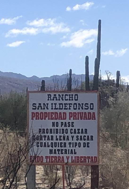
I have not been there since the gate was installed. I was last there in 2017. The gate was reported to me by a Nomad, who took photos.
There is no ranch on that side road.
Photo from Nomad 'Mothership'

[Edited on 1-16-2020 by David K]
|
|
|
David K
Honored Nomad
        
Posts: 65436
Registered: 8-30-2002
Location: San Diego County
Member Is Offline
Mood: Have Baja Fever
|
|
Montevideo has been published, with driving directions, since the 1967 edition of the Lower California Guidebook. There has never been any graffiti
(the modern kind) added. For a few years (2000s) INAH had even erected a sign pointing the way at the junction.
A flash flood made the road pretty sandy so 4WD was best after it (2016 or before?).
I was there in 2016 and 2017, and saw no reason to fence it off. Well, at least we have photographed it well, so the art is preserved. It is just
extra special to see it in person.
|
|
|
bajaric
Senior Nomad
  
Posts: 675
Registered: 2-2-2015
Member Is Offline
|
|
From the sign, they are concerned about hunting and wood gathering. It is interesting to note that most of Baja is private property. In the US the
first thing an owner of private property does is put up a fence and post it no trespassing. In the past, land owners in Baja did not seem to care
much about people going on their land, kind of a Mexican thing. I think this might be simply because it is expensive to put up fencing on thousands
of miles of dirt roads, or perhaps in Mexico there a more fundamental view of the land as belonging to the people, from the revolution that
redistributed land from the aristocracy to the masses, an event that has no parallel in the US.
|
|
|
wilderone
Ultra Nomad
    
Posts: 3895
Registered: 2-9-2004
Member Is Offline
|
|
I found a reference in a Mexican document called: AGRICULTURAL DEVELOPMENT FUND OF THE STATE OF BAJA CALIFORNIA
FOFAEBC Support Program for Investment in Equipment and Infrastructure 2013 - Traditional Productive Assets Component
There is a listing for the applicant name of Ruben Roman Daggett, apparently the owner of Rcho San Idelfonso, in Ejido Tierra & Libertad, for a
project for [as translated from Spanish] "acquisition of 5000 ltrs R-20 nurse tank with 2 connection"
So maybe if there is a well with water lines or something, and a gate to protect that infrastructure asset.
???
|
|
|
David K
Honored Nomad
        
Posts: 65436
Registered: 8-30-2002
Location: San Diego County
Member Is Offline
Mood: Have Baja Fever
|
|
Good investigative work, Cindi!
There would be no need for a well up in that valley unless a new ranch was going in, so maybe there is? I guess we can ask Reuben at Daggett's Camp?
Thank you!
|
|
|
billklaser
Nomad
 
Posts: 142
Registered: 3-31-2011
Location: Loreto, Lopez Mateos
Member Is Offline
|
|
There is supposed to be some hot springs between Puerto Al Meja and Punta Pulpito north of Loreto. Never been there, but my Mexican fishing guide has
told me about it.
|
|
|
wilderone
Ultra Nomad
    
Posts: 3895
Registered: 2-9-2004
Member Is Offline
|
|
Interesting. Probably have to get there by boat.
"Punta Púlpito volcano is a lava dome which formed about 500,000 years ago on a small peninsula at the Gulf of California east of the southern tip of
Bahía Concepción. It is included in the catalogue of potentially active volcanoes because it still has an active geothermal system with hot springs
and steaming ground. One active geothermal field is known as the Saquicismunde geothermal area, and the larger Los Volcanes geothermal area, located
along the coast about 5 km south of Punta el Púlpito, contains 18 fumaroles along a NW-SE alignment. The Saquicismunde geothermal area with
hydrothermal springs and steaming ground lies close to the dome."
|
|
|
4x4abc
Ultra Nomad
    
Posts: 4454
Registered: 4-24-2009
Location: La Paz, BCS
Member Is Offline
Mood: happy - always
|
|
Saquicismunde Cove is exactly 5 km from Punta Pulpito
sailors frequent the cove
haven't seen any reports of fumaroles yet
Harald Pietschmann
|
|
|
| Pages:
1
..
3
4
5 |

