| Pages:
1
..
3
4
5
6
7
..
9 |
David K
Honored Nomad
        
Posts: 65434
Registered: 8-30-2002
Location: San Diego County
Member Is Offline
Mood: Have Baja Fever
|
|
Froyland's 2013 book is great... a detailed summary of his travels by foot, horseback, and 4x4 from 1962 to 2008. Primarily in the Sierra San Pedro
Mártir and the canyons.
The cover of his 'Baja California Adventures' was simply a generic cover for any travel story books published by Xlibris (yes, a terrible cover for a
book that has nothing to do with motorhomes and paved highways).
Froyland also has translated three historical books in the 51 volume Dawson Baja California Travels Series...
#17 José Joaquin Arrillaga, 1796 Diary (in 1969).
#43 The Natural History of Baja California by Miguel del Barco (in 1980).
#44 Ethnology and Linguistics of Baja California by Miguel del Barco (in 1981).

Look who helped Froyland translate: Camping and Climbing in Baja author, John Robinson.
|
|
|
Vince
Nomad
 
Posts: 448
Registered: 10-17-2006
Location: Coronado
Member Is Offline
|
|
David, thanks for alerting me about this thread on the canyons on the eastern slope of the SPM mountains. I took four trips with Bud Bernard to the
SPM in the 1950's starting in '53. I was in high school then as were some of my friends who were with us. Also a group of Sierra Club folks, we were
all hiking and we started at the Meling ranch during Easter week. Phil Meling and some wranglers came on 2 trips that we rode horses. Bud would run
ahead on foot and meet us at the next camp site. One of those trips that Bud led was from the desert side up Diablo canyon in about 1959. This was a
dedicated mountain climbing trip with some good climbers along. Bud wanted to measure both peaks of Picacho del Diablo and took a device along on his
back to do it with, a transit, I believe. The canyon was beautiful, the first day we had to leave our packs, swim across a clear pond at the bottom
of a waterfall and climb up a cliff alongside the waterfall. We belayed our packs over the water with a rope we brought and got them all across. It
took two days going up to the summit camp, one day to summit and the same going back. I forget which peak was higher, but one was about 6 or 8 feet
higher than the other one as measured by Bud. We climbed both peaks to figure it out. As for the other guys you mentioned, they were not with us and
I did not know them. Those were great personal memories and I am reminded of them every time I fly or drive past Picacho del Diablo.
[Edited on 12-4-2021 by Vince]
|
|
|
4x4abc
Ultra Nomad
    
Posts: 4454
Registered: 4-24-2009
Location: La Paz, BCS
Member Is Offline
Mood: happy - always
|
|
Quote: Originally posted by David K  |
Froyland also has translated three historical books in the 51 volume Dawson Baja California Travels Series...

Look who helped Froyland translate: Camping and Climbing in Baja author, John Robinson. |
Camping and Climbing in Baja triggered my very first Baja exploration in 1986 - finding Cañon el Palomar and locating Pole Line Road. I got lost so
badly that my girlfriend showed up 3 days late for work.

Harald Pietschmann
|
|
|
David K
Honored Nomad
        
Posts: 65434
Registered: 8-30-2002
Location: San Diego County
Member Is Offline
Mood: Have Baja Fever
|
|
Thanks for sharing the story Vince.
What would have happened to Bud's map, do you think? The map mentioned by Froy in his book (quoted by geoffff above).
Did he have children who may still have it?
|
|
|
PaulW
Ultra Nomad
    
Posts: 3113
Registered: 5-21-2013
Member Is Offline
|
|
Where is Abejas
Abejas
Interesting canyons with no labels or discussion
Using CalTopo for coords, Using blue lines I call Grid when dealing with INEGI paper or downloaded topo’s.
Grid numbers are on the vertical right side of the Topo. Horizontal Grid numbers are ignored.
From the north Canyon on H11B45
Grid 57/58 No INEGI label. Mouth at 31 14.607, -115 26.915 A big canyon. Partly on H11B35.
Grid 55 Canos, with INEGI label. Mouth at 31 13.268, -115 27.149 A small canyon
Grid 53/54 No INEGI label. Mouth at 31 12.215, -115 26.987 A big canyon
Grid 45 Esperanza, with INEGI label. Mouth at 31 8.3, -115 25.34 A small canyon
Where is Abejas - A side canyon of a larger canyon pointing W or NW? Consider:
It is possible it is at canyon Grid 57/58 It has a pretty good side leg pointing west on H11B35.
It is not at Grid 55, Canos. A small canyon with no significant side leg like Robinson describes.
It is possible it is at canyon Grid 53/54. It has three legs one of which points quite a way west
It is not at Grid 45, Esperanza. A small canyon with no significant spur like Robinson describes.
Speculation -- Abejas could be a leg on Grids 53/54 or 57/58. Should the choice be called Esperanza per Robinson?
Of course, then we all have been hiking up the wrong Esperanza and INEGI would have another wrong label.
Of course, Robinson could have possibly made a mistake with his label?
See a shot of my tracings below, black = ridges, red = drainage. Base map is most recent download from INEGI
Grid 57/58

Grid 53/54

Grid 45

|
|
|
Vince
Nomad
 
Posts: 448
Registered: 10-17-2006
Location: Coronado
Member Is Offline
|
|
Bud Bernard had no heirs, he was quite eccentric and never married and his only sibling, a sister, died before he did. He continued to go to the
Meling ranch and lead people on trips but if it was hot, he would be incapacitated and had to be evacuated. Mrs. Meling finally asked him to not come
in the summer. I do not know what happened to his belongings of which he had very few. As time went by, he became more eccentric and would not pay
his taxes on his house in Coronado and it was confiscated by the county. His father was a retired WWl admiral and Bud inherited a very nice home.
Bud was a tail gunner on a B-17 in WWll, was shot down and he parachuted to friendly forces. I will ask the person who bought his mansion from the
county to see if she found any belongings, such as a map. I remember he talked about the canyons and access to climbing Picacho, but I never saw his
map.
|
|
|
David K
Honored Nomad
        
Posts: 65434
Registered: 8-30-2002
Location: San Diego County
Member Is Offline
Mood: Have Baja Fever
|
|
Quote: Originally posted by Vince  | Bud Bernard had no heirs, he was quite eccentric and never married and his only sibling, a sister, died before he did. He continued to go to the
Meling ranch and lead people on trips but if it was hot, he would be incapacitated and had to be evacuated. Mrs. Meling finally asked him to not come
in the summer. I do not know what happened to his belongings of which he had very few. As time went by, he became more eccentric and would not pay
his taxes on his house in Coronado and it was confiscated by the county. His father was a retired WWl admiral and Bud inherited a very nice home.
Bud was a tail gunner on a B-17 in WWll, was shot down and he parachuted to friendly forces. I will ask the person who bought his mansion from the
county to see if she found any belongings, such as a map. I remember he talked about the canyons and access to climbing Picacho, but I never saw his
map.
|
That is quite some history!
Thanks for the attempt to solve a lost map mystery!
Do you have any tales about Myron Smith? His son, Brooks, was a very interesting Baja Nomad, but died young. His Nomad name was Baja Taco at first,
then edited to 'Taco de Baja', as there was another 'Baja Taco' on Nomad (he drove a Tacoma, or 'Taco').
I met Brooks at the entrance to Parral Canyon as he and his (also Nomad) friends were going to hike up Matomi Canyon. They had just hiked to Mission
San Pedro Mártir with Baja Nomad Jack Swords (April 2004).

(L to R) Baja Taco, Huddo, Mexitron, and Pappy
I made a web page of their hikes in Baja: http://vivabaja.com/mexitron/
|
|
|
Vince
Nomad
 
Posts: 448
Registered: 10-17-2006
Location: Coronado
Member Is Offline
|
|
No, no stories about those guys, I didn't know them. Looks to be an interesting chapter on Baja hiking and climbing. Bud did some good work when he
rescued the Kellogg kid, Ogden, and his girlfriend, Eleanor Dart (O'Bryon). Eleanor wrote a book, which I have, Coming Home from Devil Mountain, all
about their rescue when they got lost climbing Picacho del Diablo in 1967. I think I will read it again.
|
|
|
JZ
Select Nomad
      
Posts: 13923
Registered: 10-3-2003
Member Is Offline
|
|
Awesome thread.
|
|
|
David K
Honored Nomad
        
Posts: 65434
Registered: 8-30-2002
Location: San Diego County
Member Is Offline
Mood: Have Baja Fever
|
|
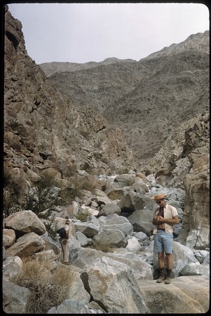
Bud Bernhard in 1961
Howard Gulick (Lower California Guidebook) photographed Bud in the Sierra Cucapá, on Feb 12, 1961:

[Edited on 12-6-2021 by David K]
|
|
|
Barry A.
Select Nomad
      
Posts: 10007
Registered: 11-30-2003
Location: Redding, Northern CA
Member Is Offline
Mood: optimistic
|
|
Quote: Originally posted by David K  | Thanks for sharing the story Vince.
What would have happened to Bud's map, do you think? The map mentioned by Froy in his book (quoted by geoffff above).
Did he have children who may still have it?
|
I was alerted via e-mail this morning to this BAJA NOMAD "thread" (Canyons) by Dr. Vince Flynn of Coronado, a Coronado high-school classmate of mine
and good friend. I knew Edward "Bud" Bernhard pretty well back in the '50's and '60's, and beyond, and went on several of his trips into Northern
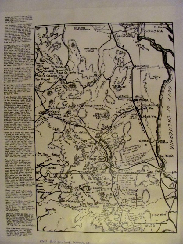
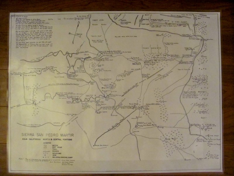
Baja. I believe I have a copy of the Map referred to by Geoff, and other's above. I also have a copy of the "Dec. 12,1963" freehand-map prepared by
Bud Bernhard at the request of Al Schmitz of the Sierra Club dealing with that portion of the San Pedro Martir plateau and west-facing foot hills just
west of Picacho del Diablo and east of Melings Ranch. It also deals with the some of the canyons and their names on the eastern slope of the San
Pedro Martir just south of Picacho del Diablo and north of Matomi Canyon. I am not tech-savvy enough to include photos of the 2 maps, unfortunately,
and I live in Redding, CA north of Sacramento. The 2 maps are laminated back-to-back in heavy duty pliable plastic (2' 4" X 1' 9") and are in
excellent condition and have many interesting comments by Bud on both of them. I also knew "Myron Smith" casually, but unfortunately have no details
about him that I can relate or remember other than he was a very interesting fellow Baja traveler back in the '60's.
|
|
|
David K
Honored Nomad
        
Posts: 65434
Registered: 8-30-2002
Location: San Diego County
Member Is Offline
Mood: Have Baja Fever
|
|
Hi Barry, and it was me who alerted Vince, lol.
Can you scan the maps and email them to me? Otherwise, please email the photos and I will post them.
You are a Baja treasure!
|
|
|
Barry A.
Select Nomad
      
Posts: 10007
Registered: 11-30-2003
Location: Redding, Northern CA
Member Is Offline
Mood: optimistic
|
|
David---------I will get with my slightly more tech-savvy wife and see what we can come up with on photos of the maps and sending them to you. There
is a LOT of small detail on the maps, so it may be hard to capture everything on a photo.
|
|
|
PaulW
Ultra Nomad
    
Posts: 3113
Registered: 5-21-2013
Member Is Offline
|
|
Barry, if you are using your phone use max resolution
Thanks.
|
|
|
David K
Honored Nomad
        
Posts: 65434
Registered: 8-30-2002
Location: San Diego County
Member Is Offline
Mood: Have Baja Fever
|
|
Quote: Originally posted by Barry A.  | | David---------I will get with my slightly more tech-savvy wife and see what we can come up with on photos of the maps and sending them to you. There
is a LOT of small detail on the maps, so it may be hard to capture everything on a photo. |
What ever I can do to help on this end, you have my assistance. If you don't have a scanner on your PC or have Copy shop in your village, then
close-up photos may work, even if they are in parts. Geoffff, here on Nomad, is amazing at stitching together pieces of a map to make it whole again!
David
|
|
|
David K
Honored Nomad
        
Posts: 65434
Registered: 8-30-2002
Location: San Diego County
Member Is Offline
Mood: Have Baja Fever
|
|
Bud's Maps from Barry A
Two images... posting here as I got them... but, I also sent them to geoffff, who is a wizard at improving map images, so stay tuned...
Edit: Scroll down to see better imagery...
[Edited on 12-7-2021 by David K]
|
|
|
Barry A.
Select Nomad
      
Posts: 10007
Registered: 11-30-2003
Location: Redding, Northern CA
Member Is Offline
Mood: optimistic
|
|
Yikes!!!!! Map pictures came out very fuzzy and hard to read. Sorry!! I will try again later-----like tomorrow. Need more light and a steady hand
with the camera. B
|
|
|
David K
Honored Nomad
        
Posts: 65434
Registered: 8-30-2002
Location: San Diego County
Member Is Offline
Mood: Have Baja Fever
|
|
No worries... but if you can get closer and take a photo of just a half then the other half of each map for better size resolution. Have a bright
light on it if possible.
Thanks!
|
|
|
JZ
Select Nomad
      
Posts: 13923
Registered: 10-3-2003
Member Is Offline
|
|
Quote: Originally posted by Barry A.  | | David---------I will get with my slightly more tech-savvy wife and see what we can come up with on photos of the maps and sending them to you. There
is a LOT of small detail on the maps, so it may be hard to capture everything on a photo. |
The easiest way to get a very high res copy would be to take them to a FedEx Office Print Center. They are all over.
They will be able to scan them for you. And will email them in PDF format. Then you can email to DK. Shouldn't cost more than a couple dollars.
[Edited on 12-7-2021 by JZ]
|
|
|
mtgoat666
Platinum Nomad
       
Posts: 20552
Registered: 9-16-2006
Location: San Diego
Member Is Offline
Mood: Hot n spicy
|
|
Quote: Originally posted by JZ  | Quote: Originally posted by Barry A.  | | David---------I will get with my slightly more tech-savvy wife and see what we can come up with on photos of the maps and sending them to you. There
is a LOT of small detail on the maps, so it may be hard to capture everything on a photo. |
The easiest way to get a very high res copy would be to take them to a FedEx Office Print Center. They are all over.
They will be able to scan them for you. And will email them in PDF format. Then you can email to DK. Shouldn't cost more than a couple dollars.
[Edited on 12-7-2021 by JZ] |
Large-format scans cost more like $10 to $20 per sheet.
Woke!
Hands off!
“Por el bien de todos, primero los pobres.”
“...ask not what your country can do for you – ask what you can do for your country.” “My fellow citizens of the world: ask not what America
will do for you, but what together we can do for the freedom of man.”
Pronoun: the royal we
|
|
|
| Pages:
1
..
3
4
5
6
7
..
9 |

