| Pages:
1
..
4
5
6 |
David K
Honored Nomad
        
Posts: 65453
Registered: 8-30-2002
Location: San Diego County
Member Is Offline
Mood: Have Baja Fever
|
|
Wash 4 is the only one of the three that easily goes to the top and beyond... however, all three are really way beyond the distance of a one day walk
from the Model A, I think? Even my choice (Arroyo B) is pushing it for distance... but it had the landmarks easily seen from space.
The guys began their walk early and got to the rock pile at noon (5-6 hours = 10-12 miles). They then continued down to Arroyo Grande where they spent
the night.
The second day they followed Arroyo Grande to the base of Borrego Mountain, then back to the Model A. (20-25 miles max?)
|
|
|
TMW
Select Nomad
      
Posts: 10659
Registered: 9-1-2003
Location: Bakersfield, CA
Member Is Offline
|
|
Maybe I'm missing what he means by the base of Borrego Mtn as to me A. Grande does not go to what I think is the Mtn base. Arroyo Arrajal does as I
see it. That's why I don't think he got to A. Grande.
|
|
|
David K
Honored Nomad
        
Posts: 65453
Registered: 8-30-2002
Location: San Diego County
Member Is Offline
Mood: Have Baja Fever
|
|
Quote: Originally posted by TMW  | | Maybe I'm missing what he means by the base of Borrego Mtn as to me A. Grande does not go to what I think is the Mtn base. Arroyo Arrajal does as I
see it. That's why I don't think he got to A. Grande. |
At either #13 or #14 on your map is where he would be near the north slopes of Borrego and likely left Arroyo Grande to cross back east into Arroyo el
Arrajal and return to the Model A.
|
|
|
Bug
Junior Nomad

Posts: 62
Registered: 11-12-2005
Location: San Felipe, Baja
Member Is Offline
Mood: Life can not get better than this!
|
|
I have been at the window shape rock behind La Ventena. And there is another off the Hwy 5 were the Rio Hardy starts behind the mountains. Next time I
am out there and riding around I will look for Diaz grave. Thank David K for sharing all the information.
|
|
|
PaulW
Ultra Nomad
    
Posts: 3113
Registered: 5-21-2013
Member Is Offline
|
|
Tom,
Thanks for the pics and coords. Saved me a lot of time to get the coords from GE. Turns out effort on GE is way inadequate compared to your list. I
re-did my AG GPS track with your wash WPs. I will drive there soon, but am leading a trip so I wont have time for any hikes. I should be able to grab
some more pics and clean up my cobbled up GPS track.
BTW, I am still a skeptic about where those 2 guys camped? My take is unless they walked easterly to the headwaters of Arrajal wash a trek over the
mountains would be a really big deal. On my to do list is to drive to those headwaters just to see how far I can get so I can define a real WP.
I will elaborate after more research and drives.
Paul
|
|
|
David K
Honored Nomad
        
Posts: 65453
Registered: 8-30-2002
Location: San Diego County
Member Is Offline
Mood: Have Baja Fever
|
|
In Henderson's letter, they camped in Arroyo Grande... then the next day hiked to the base of Borrego Mountain and returned back to the Model A.
|
|
|
mexicali-kid
Junior Nomad

Posts: 44
Registered: 4-28-2014
Member Is Offline
|
|
Very good story, but who is going to take a Ford Model A, a fairly new vehicle at the time, Manufactured from 1927-31 to the desert? And then they
just leave it while they hike around for a couple of days ? This doesn't pass the sniff test.
We know Melchior Diaz was in the delta of the Colorado because he described an unusual feature. There was a volcano in the delta. Today it's called
Cerro Prieto. 18 miles south of Mexicali.
We know he was injured while chasing dogs that were harassing his sheep. Our location of the accident should be near forage and water because of the
sheep. So along with the volcano description we can guess he was somewhere along the western edge\grasslands of the delta.
It is unlikely that after the injury his group traveled/explored any more. They would have turned back.
If he died soon afterward I would look for a grave "on a hill overlooking a narrow valley" in the Sierra Cucupa near Cerro Prieto or across the river
near Yuma.
If he lived 20 more days as is often reported, He is probably buried 100 miles from the Colorado Delta area. Somewhere up the Gila or Colorado Rivers
as his group would have tried to reconnect with Coronado or return to Mexico.
Been looking for 20 years. Haven't found it yet.
|
|
|
TMW
Select Nomad
      
Posts: 10659
Registered: 9-1-2003
Location: Bakersfield, CA
Member Is Offline
|
|
I don't disagree with you as to where he may be buried. To me finding this rockpile of Hendersons is a search of its own and I'm interested in what is
there. Maybe nothing or maybe something.
|
|
|
TMW
Select Nomad
      
Posts: 10659
Registered: 9-1-2003
Location: Bakersfield, CA
Member Is Offline
|
|
Paul make sure you check out DKs B location since I did not get it.
At or near 31-32.950x115-19.170.
|
|
|
David K
Honored Nomad
        
Posts: 65453
Registered: 8-30-2002
Location: San Diego County
Member Is Offline
Mood: Have Baja Fever
|
|
Hi Mexicali, thanks for posting!
In the 1930's, leaving your car that far from civilization was not a worry, the road to San Felipe wasn't paved until the 1950's and the paved road to
Ensenada from El Chinero (Hwy. 3 now) wasn't finished until 1978.
There are also bubbling mud pots near the Salton Sea... but I favor the Cerro Prieto site, naturally.
As for why the Diaz party continued south after the injury, it was to try and meet Alacron's ship (at San Felipe?) and they hugged the mountains to
have access to fresh water and to avoid the swamps and salt flats of the delta and Laguna Salada... that's my guess!
|
|
|
David K
Honored Nomad
        
Posts: 65453
Registered: 8-30-2002
Location: San Diego County
Member Is Offline
Mood: Have Baja Fever
|
|
Quote: Originally posted by TMW  | | I don't disagree with you as to where he may be buried. To me finding this rockpile of Hendersons is a search of its own and I'm interested in what is
there. Maybe nothing or maybe something. |
It is not the destination, but instead it is the journey!
Same reason we all went looking of elbeau's Santa Isabel Google Earth site in Arroyo el Volcan, back in 2011. What fun was that? Lot's! Also, it was
Baja Lou's last adventure before his final great one... and I think we all were very proud to share that with him... he really enjoyed it. Finding the
Henderson 'rock-pile' should be a BajaLou memorial event, as he wanted to look for it.
|
|
|
PaulW
Ultra Nomad
    
Posts: 3113
Registered: 5-21-2013
Member Is Offline
|
|
Quote: Originally posted by TMW  | Paul make sure you check out DKs B location since I did not get it.
At or near 31-32.950x115-19.170. |
========
Got it
|
|
|
PaulW
Ultra Nomad
    
Posts: 3113
Registered: 5-21-2013
Member Is Offline
|
|
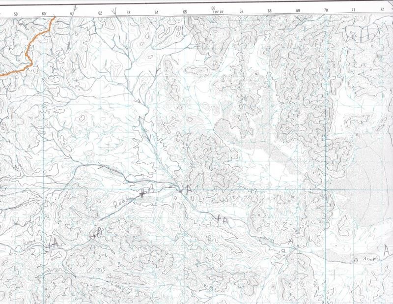
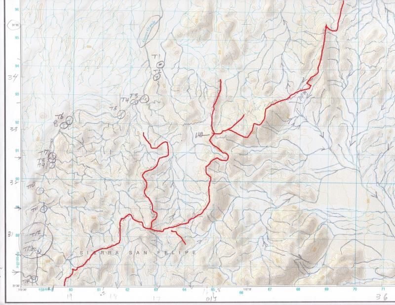
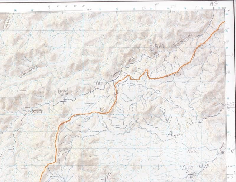
Watershed Divide
Watershed divide just east of Arroyo Grande
Maps are INEGI H11Bxx, I made the scans from hard copy - not download images.
NW of 36 mates with NE corner of 35
SW of 26 mates with NW of 36
Orange line defines the divide
A is Arroyo Arrajal
Note two major drainages feeding Arrajal
The major drainage on Map 26 dumps north of where they parked and is close to PPW.
Map 36 Datum 27

Map 26 Datum 92

Map 35 Datum 92

|
|
|
güéribo
Nomad
 
Posts: 239
Registered: 10-17-2014
Member Is Offline
|
|
Regarding Melchior Diaz, have you read "The Devil's Highway" by Luis Alberto Urrea? A sobering and informative book (plus it's quite a page-turner)
about a group of migrants attempting to cross the border, who tragically died in the Arizona desert and became known as the "Yuma 14."
Urrea begins his book with Melchior Diaz:
January 18,1541.
Sonoita (also known as Sonoyta) was perhaps not much more than sticks and mud, but it was a stopping point for a Spanish expedition in search of, what
else, gold. Even in 1541, Sonoita was the unwilling host of killers and wanderers. The leader of this clanking Spaniard patrol was a firebrand known
as Melchior Diaz. He didn't especially want to spend his holidays in the broiling dust of Sonoita, but he was deep into hostile territory. It was
commonly believed that the natives of the Devil's Highway devoured human children. The Spaniards weren't planning on settling-spread the cross around,
throw up a mission, and hit the road in search of better things.
Melchior Diaz was trying to reach the Sea of Cortez, lying between the Mexican mainland and Baja California. Perhaps he knew that ahead of him lay the
most hellish stretch of land in the entire north. The dirt paths he rode his horse down on that day are now the paved and semipaved barrio lanes of
modern Sonoita. Some of the hubcap-popping boulders in Sonoita's hillside alleys are the same rocks on which Melchior's horse's shoes struck sparks.
He died trying to kill a dog. He probably didn't have anything against canines--his troop had dogs that they used to hunt down game and humans. But
there were also the feral creatures that dashed in from the out-skirts of the settlement to slaughter his sheep. Melchior Diaz kept his sheep in small
brush corrals, attended by his Indian slaves. But the wild dogs had a way of sneaking off with lambs when nobody was looking.
And Melchior was cranky. He had spent his holidays far from home, among the savages, and even Tucson was only a small scattering of huts and lean-tos.
He couldn't have been farther from Mexico City or Spain. Sonoita was the end of the world. A Christmas in this outpost did not inspire joy. Besides,
conquistadores were notoriously short on joie de vivre.
Melchior rode well, and he rode well armed. He certainly carried a sword and a fighting dagger. He probably carried a harquebus and a long
metal-tipped lance, the M16 of the day.
Melchior was a strong man and a powerful fighter. In the narratives of the Coronado expedition, we see him plying his trade: "... the horsemen began
to overtake [the Indians] and the lances cut them down mercilessly ... until not a man was to be seen." This rout of natives serves as the preface to
the story of death that begins with Melchior Díaz.
We know that he was riding his horse down one of the settlement paths. We can project the smells swirling around him: horse, dirt, his own stink,
chickens, smoke, dung. Not all that different from the smells of today.
He was approaching his sheep pen, perhaps where the Asi Es Mi Tierra taco shop, or a Pemex station stands today. Melchior squinted ahead and--Damn it
to hell!--those lazy slaves of his had allowed a dog to get in the pen!
Perro desgraciado!
No record states how Melchior entered the pen, but it doesn't seem likely he stopped to open a gate. Not Melchior. He jumped over the fence, and in
jumping, somehow he bobbled his lance throw and missed the dog entirely. You can see the dog yipping and sidestepping and making tracks for the
horizon, casting wounded looks over his shoulder. And here is where Melchior Diaz died. The record states that Melchior, somehow, "passed over" the
lance. Did he fall from the horse? No one knows, but the lance managed to penetrate his gut and rip him open.
The desert ground must have seemed terribly hard as he hit it. As Melchior died (it took twenty gruesome days)on his stinking cot, he burned and
howled. Flies settled in his entrails. Maybe the very dog that killed him drew near to sniff the rich meaty scent. The fallen angels of Desolation
came out of the Cabeza Prieta, folded their hands over him, and smiled . . .
http://www.amazon.com/The-Devils-Highway-True-Story/dp/03160...

|
|
|
ehall
Super Nomad
   
Posts: 1906
Registered: 3-29-2014
Location: Buckeye, Az
Member Is Offline
Mood: It's 5 o'clock somewhere
|
|
Thats a great way to start a book. I liked the way it is written. Felt like I was watching it happen.
|
|
|
güéribo
Nomad
 
Posts: 239
Registered: 10-17-2014
Member Is Offline
|
|
Urrea is a great writer. And he was born in Baja. "The Devil's Highway" was a finalist for the Pulitzer Prize. From his website:
--
Luis Alberto Urrea, 2005 Pulitzer Prize finalist for nonfiction and member of the Latino Literature Hall of Fame, is a prolific and acclaimed writer
who uses his dual-culture life experiences to explore greater themes of love, loss and triumph.
Born in Tijuana, Mexico to a Mexican father and an American mother, Urrea has published extensively in all the major genres. The critically acclaimed
and best-selling author of 13 books, Urrea has won numerous awards for his poetry, fiction and essays. The Devil's Highway, his 2004 non-fiction
account of a group of Mexican immigrants lost in the Arizona desert, won the Lannan Literary Award and was a finalist for the Pulitzer Prize and the
Pacific Rim Kiriyama Prize. An historical novel, The Hummingbird's Daughter tells the story of Teresa Urrea, sometimes known as the Saint of Cabora
and the Mexican Joan of Arc. The book, which involved 20 years of research and writing, won the Kiriyama Prize in fiction and, along with The Devil's
Highway, was named a best book of the year by many publications. It has been optioned by acclaimed Mexican director Luis Mandoki for a film to star
Antonio Banderas.
Urrea's most recent novel, Into the Beautiful North, imagines a small town in Mexico where all the men have immigrated to the U.S. A group of young
women, after seeing the film The Magnificent Seven, decide to follow the men North and persuade them to return to their beloved village. A national
best-seller, Into the Beautiful North, earned a citation of excellence from the American Library Association Rainbow's Project. A short story from
Urrea's collection, Six Kinds of Sky, was recently released as a stunning graphic novel by Cinco Puntos Press. Mr.Mendoza's Paintbrush, illustrated by
artist Christopher Cardinale, has already garnered rave reviews and serves as a perfect companion to Into the Beautiful North as it depicts the same
village in the novel.
Into the Beautiful North, The Devil's Highway and The Hummingbird's Daughter have been chosen by more than 30 different cities and colleges for One
Book community read programs.
Urrea has also won an Edgar award from the Mystery Writers of America for best short story (2009, "Amapola" in Phoenix Noir). His first book, Across
the Wire, was named a New York Times Notable Book and won the Christopher Award. Urrea also won a 1999 American Book Award for his memoir, Nobody's
Son: Notes from an American Life and in 2000, he was voted into the Latino Literature Hall of Fame following the publication of Vatos. His book of
short stories, Six Kinds of Sky, was named the 2002 small-press Book of the Year in fiction by the editors of ForeWord magazine. He has also won a
Western States Book Award in poetry for The Fever of Being and was in The 1996 Best American Poetry collection. Urrea's other titles include By the
Lake of Sleeping Children, In Search of Snow, Ghost Sickness and Wandering Time.
Urrea attended the University of California at San Diego, earning an undergraduate degree in writing, and did his graduate studies at the University
of Colorado-Boulder.
After serving as a relief worker in Tijuana and a film extra and columnist-editor-cartoonist for several publications, Urrea moved to Boston where he
taught expository writing and fiction workshops at Harvard. He has also taught at Massachusetts Bay Community College and the University of Colorado
and he was the writer in residence at the University of Louisiana-Lafayette.
Urrea lives with his family in Naperville, IL, where he is a professor of creative writing at the University of Illinois-Chicago.
|
|
|
David K
Honored Nomad
        
Posts: 65453
Registered: 8-30-2002
Location: San Diego County
Member Is Offline
Mood: Have Baja Fever
|
|
That was some creative writing twists he added to the Diaz story! He mentions Tucson, which didn't exist until over 200 more years after Diaz died!
Thanks for the link!
|
|
|
David K
Honored Nomad
        
Posts: 65453
Registered: 8-30-2002
Location: San Diego County
Member Is Offline
Mood: Have Baja Fever
|
|
OK, for newest discussion and the 2015 expedition to find Captain Diaz, please go to the Baja Hiking Forum, here: http://forums.bajanomad.com/viewthread.php?tid=78057
|
|
|
David K
Honored Nomad
        
Posts: 65453
Registered: 8-30-2002
Location: San Diego County
Member Is Offline
Mood: Have Baja Fever
|
|
For those not familiar with this historical interest subject having read Fatboy's latest posts.... bumping up.
|
|
|
| Pages:
1
..
4
5
6 |

