| Pages:
1
..
4
5
6
7
8
9 |
Mexitron
Ultra Nomad
    
Posts: 3397
Registered: 9-21-2003
Location: Fort Worth, Texas
Member Is Offline
Mood: Happy!
|
|
The "chute" looks like a path to get on top of the mesa to me but it also doesn't look like the best place to have a path--David, you were saying the
Mesa is very steep--unless there was something at the bottom or top of the mesa in that spot that made a direct path better...did the rocks put aside
for the path have the desert varnish as the rock walls?
|
|
|
Taco de Baja
Super Nomad
   
Posts: 1913
Registered: 4-14-2004
Location: Behind the Orange Curtain, CA
Member Is Offline
Mood: Dreamin' of Baja
|
|
| Quote: | Originally posted by David K
Here is a zoom in on that cleared 'chute' or slide that I thought may have been where supplies for the Spanish fort on top (or whatever was on top)
were dragged or pulled up by rope...
This is very steep... we climbed up/ and back down just to the left of it, because using rocks to hold or step on seemed easier, it was that steep.
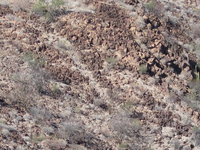
What do you think???
|
The geologist in me says that the chute is natural. The action of flowing water is removing the desert varnish creating the white strip we see in the
photo.
Also, if it as steep as you claim, no one in their right mind would try to clear a trail of 200-300+ pound rocks by placing them on the sides of the
trail. If they had, I think you would have seen their crushed bones at the bottom. Also, if they had tried, say in the delirium of being out in the
120 degree heat of an August day, it still would have been easier to roll the boulders down the slope, and I don’t see a pile at the bottom.
Furthermore, people (Native American, and modern) generally put trails at an angle across the face of slopes, not perpendicular. You may have to take
more steps, but it is a lot easier to go up (and down) a gradual slope.
Just my $0.02….
Truth generally lies in the coordination of antagonistic opinions
-Herbert Spencer
|
|
|
David K
Honored Nomad
        
Posts: 65422
Registered: 8-30-2002
Location: San Diego County
Member Is Offline
Mood: Have Baja Fever
|
|
The chute was sand... not white rock... It was just too steep to use... would have requiread 'all fours'... We did the typical switchback type climb,
just to the left of the chute and didn't need to use hands much.
All the rocks were darkened... most all. We did see some quartz at the top... probably brought there?
As for natural... It's top end was not at the low point in the saddle above... It was to the right of the natural water course if it rained. Almost
done so on purpose, to prevent the sand from eroding away to the basalt base.
That's why it seemed to me man made... and for a purpose other than climbing up for people. 
|
|
|
David K
Honored Nomad
        
Posts: 65422
Registered: 8-30-2002
Location: San Diego County
Member Is Offline
Mood: Have Baja Fever
|
|
| Quote: | Originally posted by jdtrotter
Interesting picture of San Borja on the front of that book----good for comparison to today.
I am always a little ambivalent about missions. I love visiting old historical sites, and I have always enjoyed the missions in both Californias.
The ambivalence comes from understanding the brutality of the system in regards to the indigenous populations.
I do cringe when I see the California 4th grade mission project done year after year, the one that the students used to do until the parents started
competing. They teach such a fantasized version of that part of California history.
Good luck on finding more information about the wall, etc. |
Both my kids built the missions for their 4th grade projects. Drove me crazy to hear such things as San Diego was the FIRST California mission and the
missions were all placed a days ride apart...
Loreto was the first misson, and San Diego was founded long after some 17 Jesuit missions and one Franciscan mission was founded on the peninsula. San
Diego was the SECOND misson founded by Junipero Serra, after San Fernando Velicata, in Baja!
See, you got me started! LOL!!
|
|
|
David K
Honored Nomad
        
Posts: 65422
Registered: 8-30-2002
Location: San Diego County
Member Is Offline
Mood: Have Baja Fever
|
|
Dr. Eric Ritter answers Corky's question
| Quote: | Originally posted by Sharksbaja
Looking at the area it appears that at one time water was available for quite a period. That would mean food for animals as well.
The problem with that scenario is, where do you draw the line between habitation by those that built the rings and those that built the wall if in
fact the wall was built only hundreds of years ago not thousands.
Domesticated sheep were brought to the New World as early as 1494. Cortes had sheep in Mexico during the 1500s and it's possible I suppose that the
introduction of sheep could have occured then.
We'll have to research that. Sheep either domestic or Bighorn we're not mentioned in the diets at the Animas sites. I wonder if the isotope samples
that indicate mammals could have overlooked sheep as a possible contributing isotope factor . Mainly because wild sheep were around 1000 years ago.
Evidence points to an arid climate 1000-6000 years ago. It seems not to much has changed in Baja over the millennia. Cactus fruit like pitaya and
agave and seeds were main staples in the ancients diet.
So were shellfish and mammals. Dr. Ritters pdf files are copy protected unfortunately so I can't cut and paste from it but one would conclude that
the area of BOLA and Animas have similar and connected historical value.
You can conclude a lot from his papers. I would like to ask him if they have identified Bighorn or domestic sheep (or cattle) remains at any site
that was preoccupied 1000-6000 years ago.
That might add weight to the notion that the walls were indeed built to contain or direct sheep (or cattle). |
======================================================
As to mountain sheep bones in Animas/BLA sites I don't recall any in the assemblages--but the samples are very small and certainly marine-oriented.
Mountain folks could be the visitors to the coast and those involved in the wall construction and mountain sheep hunting. However, marine foods were
more easily available to them and mountain sheep also availalble in the mountains. I did find a mountian sheep bone awl in a late prehistoric
Concepcion Bay assemblage and mountain sheep are found in the rock art. Many similar questions about mountain sheep hunting and faunal assemblages
can be found in the Calif./Great Basin desert works, especially with all of the mountain sheep rock art images. Aschmann found no reports of
deliberate mountain sheep hunting--among contact groups anyhow (pg. 70). The Seri hunted them. So it is just one possibility. Cattle would be
Spanish introductions and I don't know of any cattle bone in sites off hand--other than mission digs.
Main foods at contact: sea mammals and sea turtles; agave and cactus fruits, legumes and annual plant seeds. Deer were very important off course, at
least in terms of ceremony and prestige. I have seen mountain sheep on the road between BLA and Animas so they are around. Springs and water holes
would be good ambush locations.--people tended to sometimes live a bit away from these water sources so as to not scare the animals. Mountain sheep
were probably a prestige animal, occasionally hunted. Some archaeologists would say that the big game hunting and success was related to wife
acquisition--successful hunters got the gal or two. They (sheep) do taste good.
As to the wall--I doubt domestic sheep were around here in any numbers to use a "directional" wall. A drive fence for bighorn sheep (or deer?) is
only one explanation. We can always fall back on that "ritual" explanation. How does the rock weathering/coatings compare between the rock
enclosures and the wall boulders? Could suggest a similar age if all factors of rock coating development could be considered (age, particulate matter
in the air, exposure, rock type, etc.). Hope this helps. Eric
|
|
|
Sharksbaja
Elite Nomad
     
Posts: 5814
Registered: 9-7-2004
Location: Newport, Mulege B.C.S.
Member Is Offline
|
|
Very informative, thank you Eric. So that pretty much rules out livestock. I don't see the wall as a tool for such. There are other walls in the area
as well. Perhaps they are all tied together for a common purpose.
If the water source attracted game maybe the walls(the ones on the fan) were built for the purpose of directing them one way or another without
actually containing them. More like a directional funnel for hunters.
The walls on the hill...?????
DON\'T SQUINT! Give yer eyes a break!
Try holding down [control] key and toggle the [+ and -] keys
Viva Mulege!
Nomads\' Sunsets
|
|
|
David K
Honored Nomad
        
Posts: 65422
Registered: 8-30-2002
Location: San Diego County
Member Is Offline
Mood: Have Baja Fever
|
|
Pretty weird... but it sure is fun to try and guess who, what, when and why!
|
|
|
wilderone
Ultra Nomad
    
Posts: 3894
Registered: 2-9-2004
Member Is Offline
|
|
"... the next site in Baja he is going to study, as I have been there, and am assisting him on it as much as I can/ he needs. (no, I won't tell you
where, lol)"
C'mon David, where? I bet a bunch of us have been there and we can give Ritter some advance clues.
|
|
|
Taco de Baja
Super Nomad
   
Posts: 1913
Registered: 4-14-2004
Location: Behind the Orange Curtain, CA
Member Is Offline
Mood: Dreamin' of Baja
|
|
| Quote: | Originally posted by wilderone
"... the next site in Baja he is going to study, as I have been there, and am assisting him on it as much as I can/ he needs. (no, I won't tell you
where, lol)"
C'mon David, where? I bet a bunch of us have been there and we can give Ritter some advance clues. |
Read some of David's trip reports. You can probably figure it out....there's only *** to chose from.....
Truth generally lies in the coordination of antagonistic opinions
-Herbert Spencer
|
|
|
wilderone
Ultra Nomad
    
Posts: 3894
Registered: 2-9-2004
Member Is Offline
|
|
This was interesting:
CLEARED CIRCLES AND ROCK RINGS
So-called "sleeping circles" are features, often circular in shape and typically 1.5-3.0 meters in diameter, that were formed by clearing away the
rocks from an area of desert pavement or by enclosing an area within a low rock border. Thousands of such features are known from the California
deserts. In one 9 mi.2 area in eastern San Diego County, Malcolm J. Rogers (1939:7) counted more that 500 circles. Interpretations of the origins of
the features have included prehistoric camping areas, geoglyphs, and locations of ritual activity. Some features may have been produced by modern
activities or by natural processes.
Rogers (1939, 1966) argued that the features could be assigned, at least primarily, to the earliest phase of the San Dieguito complex, which he also
termed the Malpais Industry. This age assignment was based, in part, on the absence of any Late Prehistoric artifacts in association with the circles
and their frequent occurrence in locations remote from any modern water source. The features were interpreted as "sleeping circles," within which the
early hunters had slept "like sardines in a can" (Rogers 1966:14). The absence of artifacts within or near most of the features was taken to indicate
that they were temporary sleeping areas rather than more permanent abodes (Rogers 1939:8).
Robert S. Begole (1973, 1974, 1976, 1981, 1984) conducted investigations for several years in the Anza-Borrego Desert State Park. He argued that
sleeping circles in that region dated both well back into the Pleistocene and from the later phases of the San Dieguito complex as well. Many of the
features were interpreted as living areas, extensively reused and with added "rooms." In other cases, Begole noted the association with apparent
ritual functions, such as trail shrines, geoglyphs, and presumed vision quest areas.
It is plausible to suppose that some of the region's sleeping circles may have been geoglyphs rather than habitation areas. Geoglyphs, or ground art
features of various sorts, have been reported in considerable numbers in the Colorado Desert (e.g., Rogers 1939; Solari and Johnson 1982; Von Werlhof
2004). Many were formed by clearing away areas of desert pavement or by placing rocks into linear patterns, in manners comparable to the ways the
sleeping circles were formed. Many of the geoglyphs are recognizable as such because they are representational in form or take geometrical shapes that
seem to be clearly nonfunctional, beyond serving a ritual or artistic impulse; other geoglyph shapes are more ambiguous. Circles are a common design
element for the region, frequently employed in rock art (Hedges 1970) and in pottery decoration (Rogers 1936).
Some apparent sleeping circles may be residues of recent activity. "Macahui," a concentration of such clearings in northern Baja California, was
popularly identified, variously, as a major prehistoric town, a ceremonial center, or a vast cemetery (cf. Möller and Aguilar 1982). Closer studies
showed that the features consisted, at least in considerable part, of modern gravel collection areas (Bendímez et al. 1986). A controversy has also
long surrounded the "Topoc Maze" on the Colorado River, which may be an elaborate geoglyph or another modern gravel collection location (Haenszel
1978; Rogers 1939).
The possibility that some of the cleared circles are natural rather than cultural phenomena has also been raised (e.g., Pat Welch 1985:personal
communication). Animal burrowing, the growth of bushes, sweeping of areas by wind-blown bush branches, and soil action are possible sources of some
misleading patterns.
To evaluate the disputed origins of the Macahui circles, Julia Bendímez, Don Laylander, and Héctor León (1986) suggested several archaeological tests
for distinguishing the functions of desert pavement clearings. The location of features in settings that lack water and other resources and that are
off of any natural travel route would argue against habitation use but would not be inconsistent with geoglyph construction. Large, dense
concentrations of the features would also seem to argue against habitation use, unless a taboo against the reuse of habitation circles is assumed. An
absence of associated artifacts would argue against habitation use, or at least, as Rogers suggested, against any but a very transitory habitation
use. Clearings that were made as geoglyphs or by gravel collectors would presumably favor specific sites with particularly dense desert pavement,
whereas clearings made for temporary habitation would presumably be situated to minimize the amount of effort needed to clear them. If the cleared
rocks are not accounted for within the surrounding pavement, the hypothesis of an origin in modern gravel collection or perhaps some noncultural
phenomenon would be favored. The presence or absence of patination or desert varnish on moved rocks near the features might clarify the matter of
their antiquity.
PROSPECTS
Future archaeological investigations may be able to clarify the purposes for which cleared circles and rock rings were constructed, as well as their
chronology. Relevant evidence will include detailed documentation of the features, their settings, and their contexts with respect to other features,
artifacts, and alterations in the natural pavements.
|
|
|
David K
Honored Nomad
        
Posts: 65422
Registered: 8-30-2002
Location: San Diego County
Member Is Offline
Mood: Have Baja Fever
|
|
Geoglyphs are another interesting pre-historic sample of Baja native artwork!
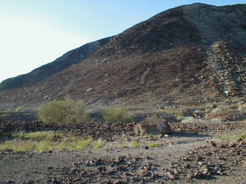
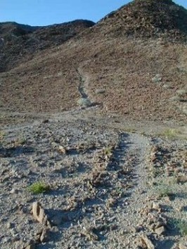
Near Mex. 5, north of Mex. 3 jcn. GPS: N 31°40.53', W 115°04.64' (NAD 27)
[Edited on 1-21-2009 by David K]
|
|
|
Sharksbaja
Elite Nomad
     
Posts: 5814
Registered: 9-7-2004
Location: Newport, Mulege B.C.S.
Member Is Offline
|
|
Pretty inconclusive. I guess we already covered their potential use(s). A water source seems to be the key to any habitational reason for their
existence. I wonder if they built them to escape winds at night. Of course it would be silly to try to escape winds on a promitory.....??
You must wonder how many people were running around the desert building these. Must have been Nomads.
DON\'T SQUINT! Give yer eyes a break!
Try holding down [control] key and toggle the [+ and -] keys
Viva Mulege!
Nomads\' Sunsets
|
|
|
avid
Junior Nomad

Posts: 41
Registered: 7-10-2008
Location: SW Oregon
Member Is Offline
Mood: adventurous
|
|
| Quote: | Originally posted by Sharksbaja
Pretty inconclusive. I guess we already covered their potential use(s). A water source seems to be the key to any habitational reason for their
existence. I wonder if they built them to escape winds at night. Of course it would be silly to try to escape winds on a promitory.....??
You must wonder how many people were running around the desert building these. Must have been Nomads. |
The Plains Indians moved to the top of buttes looking for wind to help escape mosquitos. If you have ever seen the size and daytime habits of Eastern
Montana mosquitos you could certainly understand doing anything possible to escape them.
avid
Ashland, OR
|
|
|
David K
Honored Nomad
        
Posts: 65422
Registered: 8-30-2002
Location: San Diego County
Member Is Offline
Mood: Have Baja Fever
|
|
The mosquitos were so bad at the first Santo Tomas mission site, they had to move the entire mission!
|
|
|
Taco de Baja
Super Nomad
   
Posts: 1913
Registered: 4-14-2004
Location: Behind the Orange Curtain, CA
Member Is Offline
Mood: Dreamin' of Baja
|
|
| Quote: | Originally posted by Sharksbaja
Pretty inconclusive. I guess we already covered their potential use(s). A water source seems to be the key to any habitational reason for their
existence. I wonder if they built them to escape winds at night. Of course it would be silly to try to escape winds on a promitory.....??
You must wonder how many people were running around the desert building these. Must have been Nomads. |
Maybe some really bored surfers built the wall while waiting for surf....Been known to happen. 
Truth generally lies in the coordination of antagonistic opinions
-Herbert Spencer
|
|
|
wilderone
Ultra Nomad
    
Posts: 3894
Registered: 2-9-2004
Member Is Offline
|
|
Here's a thought - after seeing David's photo of the "chute" in the zoomed-out format, it looks like the top is a bowl, with rock sides, and the chute
"flows" out of the bowl. Is that a depression in the middle which could hold water in rainy months? Don't forget how much rain can occur with a
hurricane and tropical storms. Maybe they tried to keep as much water up there as possible and the chute is a diversion flow to collect at the bottom
where some were living (?) (and because it was too inconvenient to climb up and down for the water along the steep sides).
It doesn't look like there is any evidence to demonstrate that there were a lot of people for a long time at this site. Maybe there was a rainy
period where it was thought prudent to try to save water for a season or two, and then it ran dry and there was no further reason to stay on. A
collection point, such as the flat top of the hill with a depression would be unique - no?
The walls? I got nothin. Except maybe the same water hole attracted animals and the walls kept some of them from running away too quickly and they
could drive them into this natural trap and move in for the kill. The indigenous of thousands of years ago did this with mammoths and bison. (walls
too low for this?)
|
|
|
David K
Honored Nomad
        
Posts: 65422
Registered: 8-30-2002
Location: San Diego County
Member Is Offline
Mood: Have Baja Fever
|
|
Great to keep posting ideas!
a) the top of the chute is no bowl, just were the steepness leveled out a bit... near the right end of the second (shorter) wall. Any rainfall excess
would flow down to the left of the chute... from what we observed.
b) The walls are both very low (1.5-2 ft.) and would only detract animals that can't jump, I would think. (cows, sheep, turtles lol)
[Edited on 1-22-2009 by David K]
|
|
|
David K
Honored Nomad
        
Posts: 65422
Registered: 8-30-2002
Location: San Diego County
Member Is Offline
Mood: Have Baja Fever
|
|
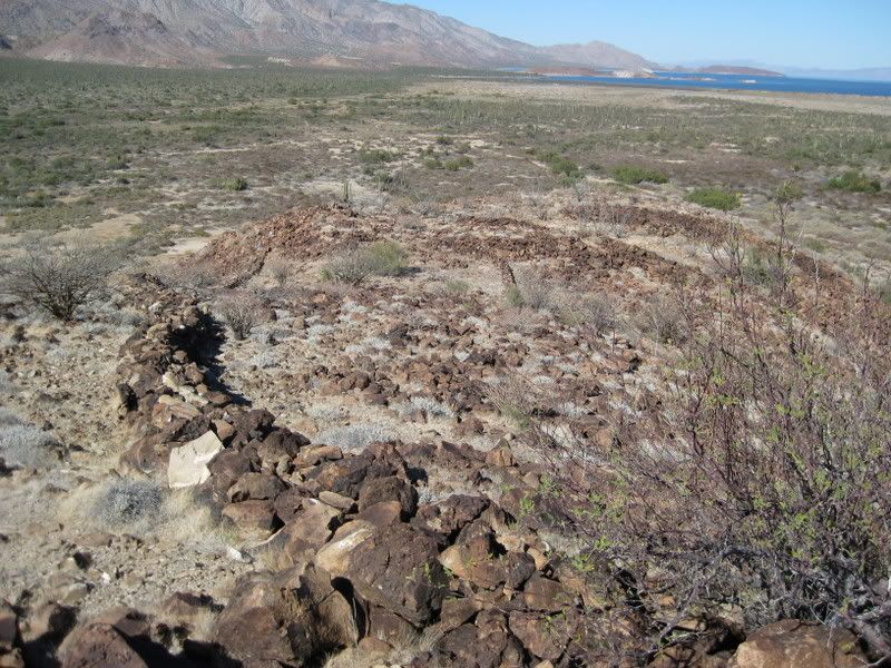
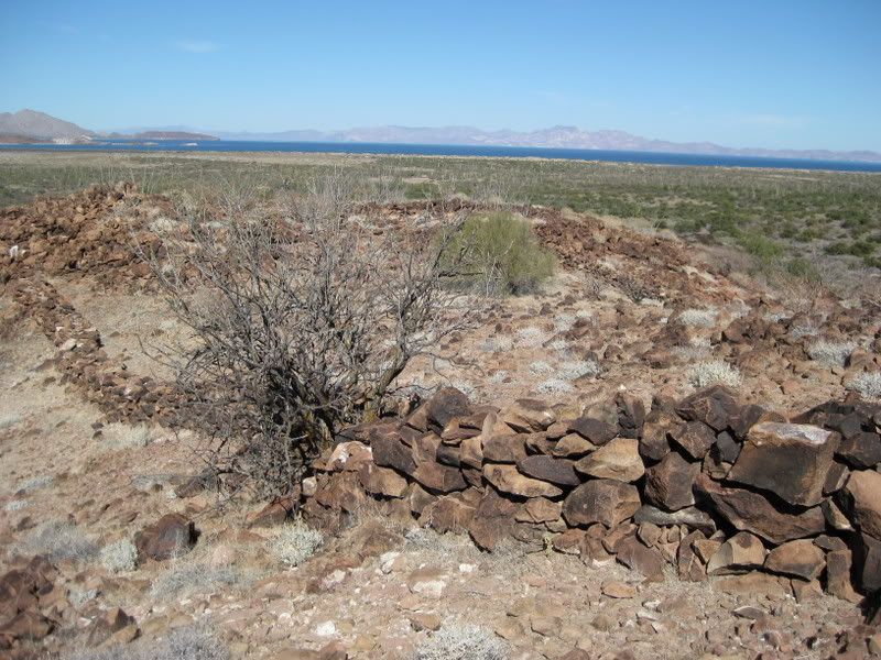
Here is looking down from the higher end of the long wall... see the sorter wall to the right? The chute goes down the steep side, to the right of the
far end of that wall... I recall that to be slightly uphill from the midpoint in the shorter wall...
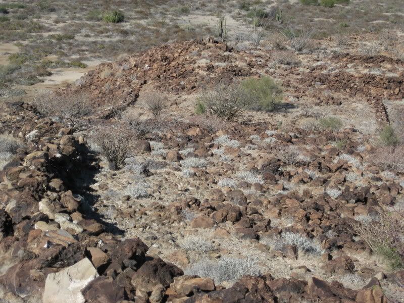
[Edited on 1-22-2009 by David K]
|
|
|
avid
Junior Nomad

Posts: 41
Registered: 7-10-2008
Location: SW Oregon
Member Is Offline
Mood: adventurous
|
|
The problem with referring to the circled rocks as "sleeping circles" is this. I have spent many nights sleeping under the stars while a wild land
firefighter both with a sleeping bag and without. I was awakened one night with a snake on my chest. It's not a great feeling when you are in
rattlesnake country. Now, why on earth would anyone want to surround themselves with rocks that snakes love to hide in. How would you know if you were
bedding down with a snake inches from your head and neck. Again, this isn't a great sounding idea at least to my way of thinking. Can you imagine a
group supposedly packed in like sardines being awakened by the sound of rattling.
HONEY, where's &%$#*@^ the flashlight.

avid
Ashland, OR
|
|
|
David K
Honored Nomad
        
Posts: 65422
Registered: 8-30-2002
Location: San Diego County
Member Is Offline
Mood: Have Baja Fever
|
|
If it where Graham Mackintosh (or the ancient natives), it would mean dinner time! 
Snake, it not just for brakfast anymore!
|
|
|
| Pages:
1
..
4
5
6
7
8
9 |

