| Pages:
1
..
4
5
6
7
8
..
25 |
DosMars
Nomad
 
Posts: 118
Registered: 12-11-2005
Member Is Offline
|
|
Almost back to the head of the canyon and the jump off point from the road in. That's as much distance in one day as headway down the canyon up until
last night.
I'm guessing he scouted down the canyon and decided to reassess things...
Or, he got scared off by a leftover holdout of the Cochimí Indians up that canyon!
[Edited on 12-29-2013 by DosMars]
|
|
|
David K
Honored Nomad
        
Posts: 65412
Registered: 8-30-2002
Location: San Diego County
Member Is Offline
Mood: Have Baja Fever
|
|
Spot Signals on 12-28-13
| Quote: | Originally posted by DosMars
Almost back to the head of the canyon and the jump off point from the road in. That's as much distance in one day as headway down the canyon up until
last night.
I'm guessing he scouted down the canyon and decided to reassess things...
Or, he got scared off by a leftover holdout of the Cochimí Indians up that canyon!
[Edited on 12-29-2013 by DosMars] |
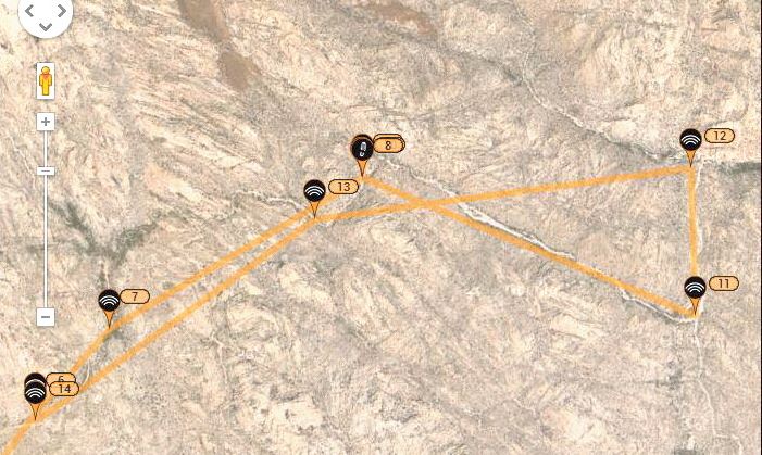
Spot 13 is by old Spot 8 and Spot 14 is at old Spot 6, just off the ranch road... So yes, he returned back to the starting point of Dec. 25. I would
guess that he came to a waterfall or boulders he couldn't get around where the wash he was going down merged with the main Salsipuedes (by Spot 12)?
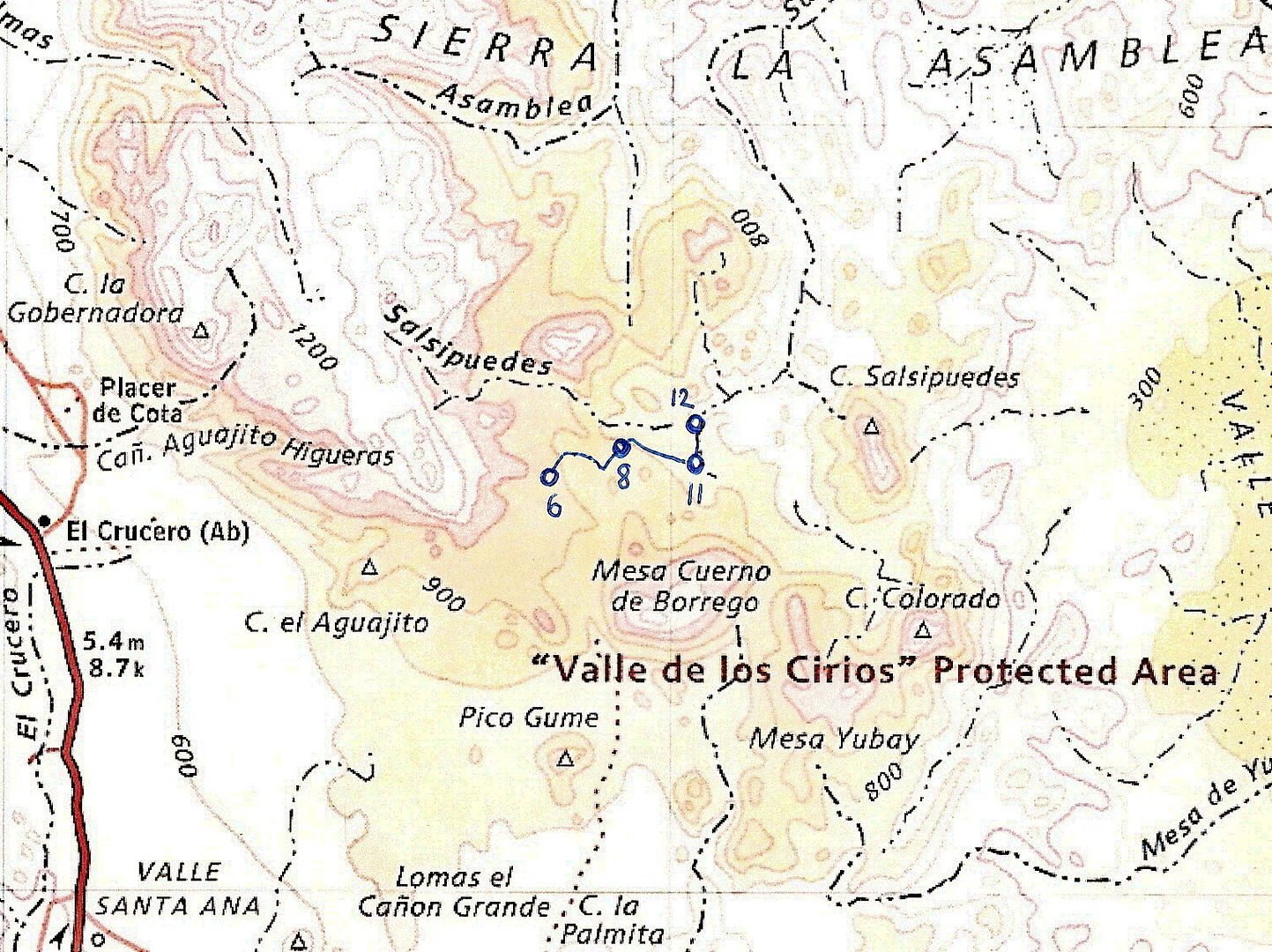
I hope he tries using that far north road that meets the main Salsipuedes, if that works for his quest! It meets Salsipuedes near the last s in
Salsipuedes on the map.
Link to Spot:
http://share.findmespot.com/shared/faces/viewspots.jsp?glId=...
|
|
|
Pacifico
Super Nomad
   
Posts: 1299
Registered: 5-26-2008
Member Is Offline
|
|
Waiting for an update.....interested in what stopped him. Hope all is well with him!
"Plan your life as if you are going to live forever. Live your life as if you are going to die tomorrow." - Carlos Fiesta
|
|
|
DosMars
Nomad
 
Posts: 118
Registered: 12-11-2005
Member Is Offline
|
|
I'm guessing portaging over those boulders was eating up more time than he has to work with. When we were down in May we drove up to the dry lakebed
closest to one of the feeder canyons that leads into Salsipuedes. My guess is he'll drive up and try hiking in from there. Then he'll be able to
finish up by riding up the canyon that dumps out just six miles from where his ride will end. Shorter paddle and a car-ride back to BoLA instead of a
long bike ride.
Just a guess, but he'll probably be online in a day or so with an update.
|
|
|
larryC
Super Nomad
   
Posts: 1499
Registered: 8-11-2008
Location: BoLA
Member Is Offline
|
|
I was a little concerned when I saw that he had ridden to the end of the road and headed down that way. There are really large boulders and drop offs
that way. Along the road before you get to the ranchos, where the large granite ridge is sticking up is another entrance to Salsipuedes and may be a
little easier to get into. Too bad there is no way to get that info to Mark. He'll probably figure it out, I don't think he is a beginner at this
stuff.
Off grid, 12-190 watt evergreen solar panels on solar trackers, 2-3648 stacked Outback inverters, 610ah LiFePo4 48v battery bank, FM 60 and MX60
Outback charge controllers, X-240 Outback transformer for 240v from inverters, 6500 watt Kubota diesel generator.
|
|
|
woody with a view
PITA Nomad
      
Posts: 15940
Registered: 11-8-2004
Location: Looking at the Coronado Islands
Member Is Offline
Mood: Everchangin'
|
|
can't wait for the details.
|
|
|
David K
Honored Nomad
        
Posts: 65412
Registered: 8-30-2002
Location: San Diego County
Member Is Offline
Mood: Have Baja Fever
|
|
Nothing new yet this morning from his Spot page. The Spot numbers did alter by one... What was #14 is now #13 (and the old #6 is now #5)... but at the
same locations as before.
|
|
|
David K
Honored Nomad
        
Posts: 65412
Registered: 8-30-2002
Location: San Diego County
Member Is Offline
Mood: Have Baja Fever
|
|
Update 12-29-13 2:25pm: Desengaño Mine
Your Local Time:
12/29/2013 2:25:23 PM
Coordinates: (WGS84)
29.11637 , -114.03148
Message Detail:
SPOT Check OK.
Mark is along the old dirt road to L.A. Bay at the El Desengaño mine ruins...
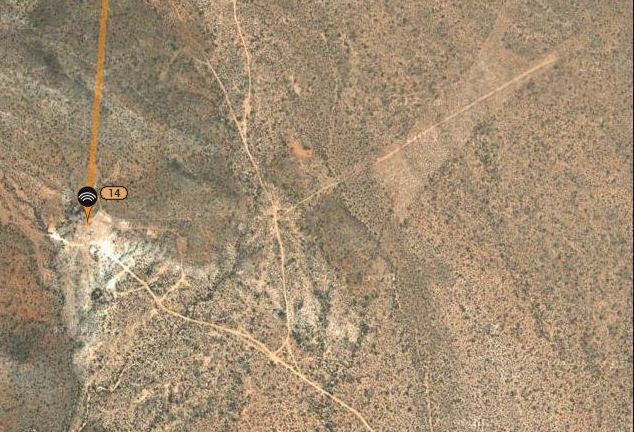
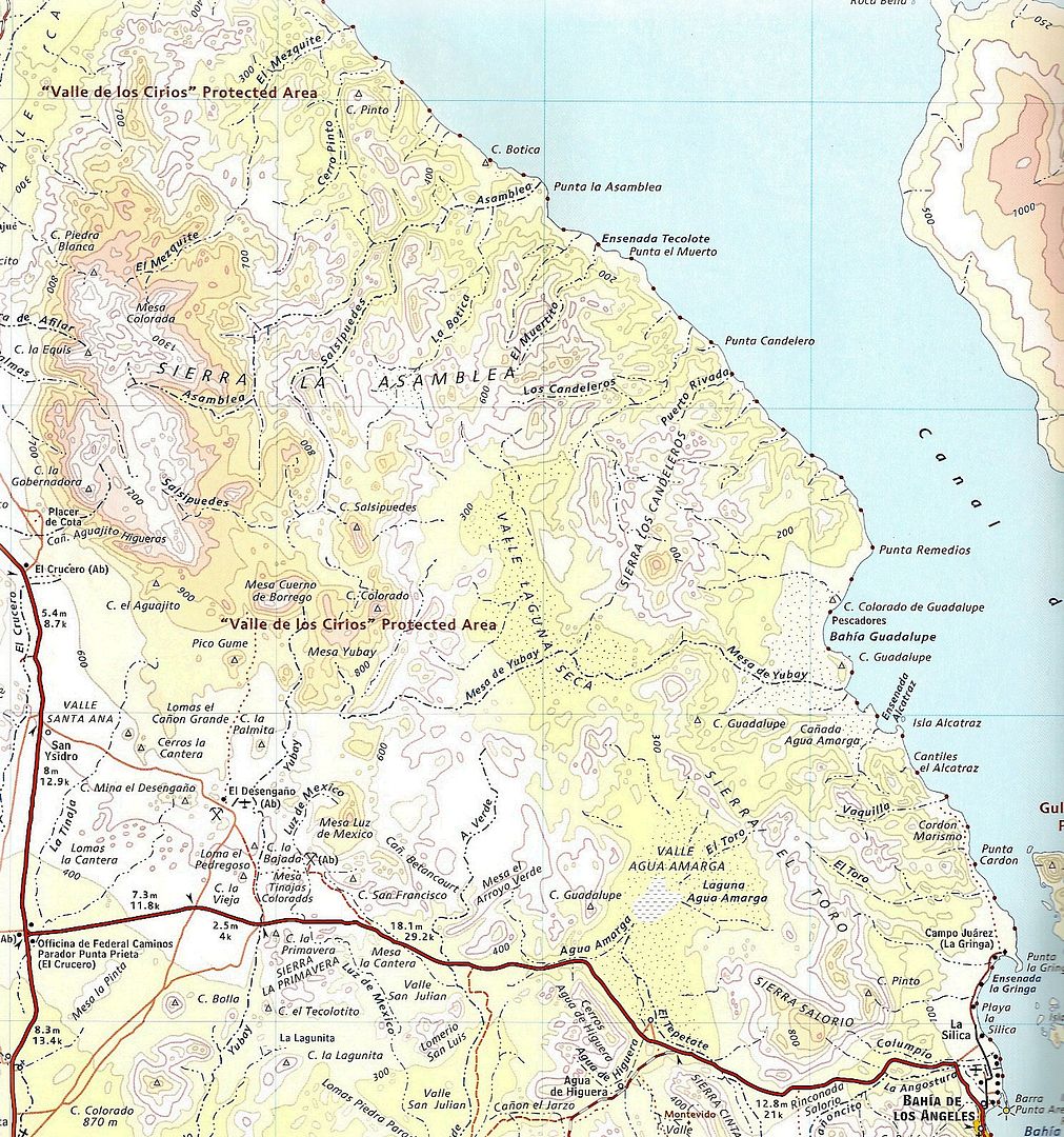
That road going north is the road to Tinaja de Yubay and Rock Palm Hill... That big X clearing is the Desengaño airport, from when the mine was
active, a long time ago.
[Edited on 12-29-2013 by David K]
|
|
|
Barry A.
Select Nomad
      
Posts: 10007
Registered: 11-30-2003
Location: Redding, Northern CA
Member Is Offline
Mood: optimistic
|
|
Well, this is disappointing, but not that surprising actually, I guess. I am sure curious as to what he ran into, and what his route was to get down
to Desengano?
Barry
|
|
|
Neal Johns
Super Nomad
   
Posts: 1687
Registered: 10-31-2002
Location: Lytle Creek, CA
Member Is Offline
Mood: In love!
|
|
It is going to be an interesting trip report.
My motto:
Never let a Dragon pass by without pulling its tail!
|
|
|
David K
Honored Nomad
        
Posts: 65412
Registered: 8-30-2002
Location: San Diego County
Member Is Offline
Mood: Have Baja Fever
|
|
It would seem to me... just a guess mind you... he came on back down the ranch road to Hwy. 1, which is also where the original dirt L.A. Bay road
meets Hwy. 1 (the old main Baja road is just a bit west of the new highway)... Mark then went on the old L.A. Bay road to Desengaño. Tomorrow's Spot
signal will tell us perhaps if he goes onto the dry lake bed or heads on to town?
|
|
|
larryC
Super Nomad
   
Posts: 1499
Registered: 8-11-2008
Location: BoLA
Member Is Offline
|
|
Darn, I figured he had a pretty good chance to make it down into there. I saw pictures of his bike in the thread but I didn't notice a pic of his
trailer. Maybe it was too big to get over some of those boulders. I guess Mark is solo, which makes it even harder. Hope he tries again.
Off grid, 12-190 watt evergreen solar panels on solar trackers, 2-3648 stacked Outback inverters, 610ah LiFePo4 48v battery bank, FM 60 and MX60
Outback charge controllers, X-240 Outback transformer for 240v from inverters, 6500 watt Kubota diesel generator.
|
|
|
woody with a view
PITA Nomad
      
Posts: 15940
Registered: 11-8-2004
Location: Looking at the Coronado Islands
Member Is Offline
Mood: Everchangin'
|
|
so you're saying spot track #14 is an actual road? why doesn't it show up better on the GE pic?
|
|
|
Barry A.
Select Nomad
      
Posts: 10007
Registered: 11-30-2003
Location: Redding, Northern CA
Member Is Offline
Mood: optimistic
|
|
| Quote: | Originally posted by woody with a view
so you're saying spot track #14 is an actual road? why doesn't it show up better on the GE pic? |
Woody-----I believe that straight-line between the "spots" is NOT a road, but don't know for sure. I too, like David K., am guessing that he got to
Desengano via the historic old dirt track road into BOLA------a beautiful way to get into BOLA even to this day, IMO.
Barry
|
|
|
Neal Johns
Super Nomad
   
Posts: 1687
Registered: 10-31-2002
Location: Lytle Creek, CA
Member Is Offline
Mood: In love!
|
|
He is on the BOLA road now, about 10 miles to BOLA.
My motto:
Never let a Dragon pass by without pulling its tail!
|
|
|
David K
Honored Nomad
        
Posts: 65412
Registered: 8-30-2002
Location: San Diego County
Member Is Offline
Mood: Have Baja Fever
|
|
| Quote: | Originally posted by Barry A.
| Quote: | Originally posted by woody with a view
so you're saying spot track #14 is an actual road? why doesn't it show up better on the GE pic? |
Woody-----I believe that straight-line between the "spots" is NOT a road, but don't know for sure. I too, like David K., am guessing that he got to
Desengano via the historic old dirt track road into BOLA------a beautiful way to get into BOLA even to this day, IMO.
Barry |
THIS.
The Spot just connects each new signal location with a straight line. Spot location #14 is where he sent the signal from... a few hundred feet north
of the road in the mine area. You can clearly see the roads, the old airport, and mine area.
|
|
|
David K
Honored Nomad
        
Posts: 65412
Registered: 8-30-2002
Location: San Diego County
Member Is Offline
Mood: Have Baja Fever
|
|
12-30-13 2:52 pm PST
| Quote: | Originally posted by Neal Johns
He is on the BOLA road now, about 10 miles to BOLA. |
Your Local Time:
12/30/2013 2:52:45 PM
Coordinates: (WGS84)
28.97412 , -113.71455
Message Detail:
SPOT Check OK.
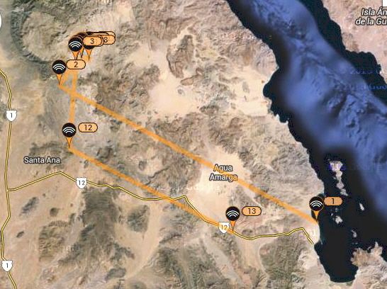
The numbers change every day... today (Monday) he is at #13, and Desengaño is showing today as #12. #2 is on the ranch road midway between Hwy. 1 and
the Salsipuedes wash access Mark used.
[Edited on 12-31-2013 by David K]
|
|
|
DosMars
Nomad
 
Posts: 118
Registered: 12-11-2005
Member Is Offline
|
|
Not sure if he was able to get a firm start date from his work regarding their next job, but he was guessing around the 13th. That gives him a couple
of more weeks to try getting in through the dry lakes.
Should be getting a check-in with an update some time tomorrow...
|
|
|
David K
Honored Nomad
        
Posts: 65412
Registered: 8-30-2002
Location: San Diego County
Member Is Offline
Mood: Have Baja Fever
|
|
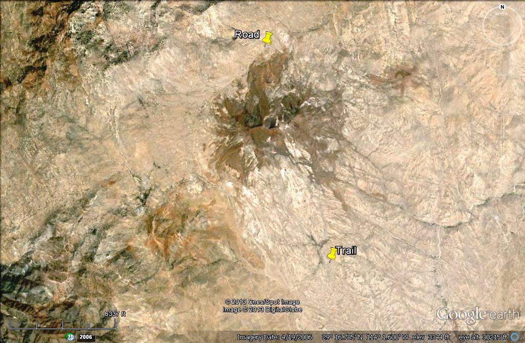
Mark, I would like to know if he tried getting in at the farther north road and just didn't send a Spot signal from it, north from where he entered
the arroyo off the ranch road? That northernmost road goes right to an arroyo that is part of La Asamblea (over that hill north from Salsipuedes where
he was).
The first image is higher up... 'Trail' is next to the arroyo where Mark hiked in with his Spot. 'Road' is the end of the road in one of the La
Asamblea tributaries.

|
|
|
DosMars
Nomad
 
Posts: 118
Registered: 12-11-2005
Member Is Offline
|
|
I imagine he followed the road to that spot on google-earth as he was prepping for the trip, but he was pretty excited about checking out those pools
and palms in the canyon he started out in.
I wish I knew how to lay down a path on the iPad version of google-earth. I'm curious about the distances he's been riding and how much water he's
been going through.
|
|
|
| Pages:
1
..
4
5
6
7
8
..
25 |

