| Pages:
1
..
4
5
6
7 |
willardguy
Elite Nomad

Posts: 6451
Registered: 9-19-2009
Member Is Offline
|
|
jeepster for your love. T Rex 
|
|
|
chuckie
Elite Nomad
Posts: 6082
Registered: 2-20-2012
Location: Kansas Prairies
Member Is Offline
Mood: Weary
|
|
what are you guys smoking? A Mexican in a 2 wheel drive Cheby, with the family in the back went over that before any of you dilletantes ever thought
of it...Shees....
|
|
|
J.P.
Super Nomad
Posts: 1673
Registered: 7-8-2010
Location: Punta Banda
Member Is Offline
Mood: Easy Does It
|
|
Quote: Originally posted by chuckie  | | what are you guys smoking? A Mexican in a 2 wheel drive Cheby, with the family in the back went over that before any of you dilletantes ever thought
of it...Shees.... |

|
|
|
chuckie
Elite Nomad
Posts: 6082
Registered: 2-20-2012
Location: Kansas Prairies
Member Is Offline
Mood: Weary
|
|
AND BALD TIRES...
|
|
|
J.P.
Super Nomad
Posts: 1673
Registered: 7-8-2010
Location: Punta Banda
Member Is Offline
Mood: Easy Does It
|
|
I cut my teeth driving on roads like that and worse in the Panhandle of Texas in my dads old 1936 Dodge.
|
|
|
rts551
Elite Nomad
Posts: 6700
Registered: 9-5-2003
Member Is Offline
|
|
Did that dodge have A$$trac? Lockers front and rear? What kinda tires?
[Edited on 12-8-2014 by rts551]
|
|
|
chuckie
Elite Nomad
Posts: 6082
Registered: 2-20-2012
Location: Kansas Prairies
Member Is Offline
Mood: Weary
|
|
Nah, Right now, me and "old Smokey" are broke down in Saint Francis Kansas, waiting for an alternator.....No A$Strac, but some Good ol Jack...
|
|
|
J.P.
Super Nomad
Posts: 1673
Registered: 7-8-2010
Location: Punta Banda
Member Is Offline
Mood: Easy Does It
|
|
| Quote: Originally posted by rts551 | Did that dodge have A$$trac? Lockers front and rear? What kinda tires?
[Edited on 12-8-2014 by rts551] |
It had Monkey Wards Street tires with a set of knobbie's in the back for really rough going. If the hill was too steep we turned around and backed up
it. and we didn't have to worry about octane we burned Drip gasoline that stuff was potent it would scorch the valves ouick
It har Monkey Wa
|
|
|
MMc
Super Nomad
Posts: 1679
Registered: 6-29-2011
Member Is Offline
Mood: Current
|
|
OOOOH you haters!
"Never teach a pig to sing it frustrates you and annoys the pig" - W.C.Fields
|
|
|
rts551
Elite Nomad
Posts: 6700
Registered: 9-5-2003
Member Is Offline
|
|
ya coined by Notorious BIG for his Gansta Rap...who woulda known the term would make it on to such a conservative forum.

|
|
|
MMc
Super Nomad
Posts: 1679
Registered: 6-29-2011
Member Is Offline
Mood: Current
|
|
I am just a OG...

"Never teach a pig to sing it frustrates you and annoys the pig" - W.C.Fields
|
|
|
David K
Honored Nomad
Posts: 65562
Registered: 8-30-2002
Location: San Diego County
Member Is Online
Mood: Have Baja Fever
|
|
| Quote: Originally posted by J.P. |
5 Will get you 10 it wasn't some Gringo in a Tacoma or Jeep 4x4 that was the first to blaze that trail |
No, it was 'gringo' Fred Hampe with dynamite and a dozer, beginning in the late 1950's.
The road was passable by VW buggy in the mid 1960's... it got worse from lack of maintenance and those without 4WD or lockers spinning tires.
Here is a photo from J.W. Black Jr. of one of the Erle Stanley Gardner custom dune buggies at the mission in the 1960's. ...
[Edited on 6-12-2023 by David K]
|
|
|
4x4abc
Ultra Nomad
Posts: 4455
Registered: 4-24-2009
Location: La Paz, BCS
Member Is Offline
Mood: happy - always
|
|
has anyone explored the supply trail from the south-west?
Harald Pietschmann
|
|
|
TMW
Select Nomad
Posts: 10659
Registered: 9-1-2003
Location: Bakersfield, CA
Member Is Offline
|
|
David K posted a write up that Norm Christie did from a Backpacking trip from Hwy 1 KM187 near Jaraguay in 1993. The last three editions of the Baja
Almanac show a trail but that is not the way Christie went. In fact I've looked for a trail several times around that area off Hwy 1 and did not find
one.
[Edited on 12-8-2014 by TMW]
|
|
|
TMW
Select Nomad
Posts: 10659
Registered: 9-1-2003
Location: Bakersfield, CA
Member Is Offline
|
|
Scrowl down to where DK posted Christie's trip report.
http://forums.bajanomad.com/viewthread.php?tid=25413
|
|
|
wessongroup
Platinum Nomad
Posts: 21152
Registered: 8-9-2009
Location: Mission Viejo
Member Is Offline
Mood: Suicide Hot line ... please hold
|
|
These don't appear to be "BFGoodrichs Unbelievable New KO2's" ... however they seem to work pretty good in this example
Thnx to the original poster of this ... great video
Hey, maybe TW ran out of "limes" .. 
|
|
|
David K
Honored Nomad
Posts: 65562
Registered: 8-30-2002
Location: San Diego County
Member Is Online
Mood: Have Baja Fever
|
|
There are two 'mission-era roads' in the region:
1) EL CAMINO REAL (Loreto to Monterey):
a) Jesuit Trail (1767-1768)
b) Franciscan/ Dominican Trail (1768-1855+)
2) SERRA's CARGO TRAIL (1769+)
Don Jorge (in one trip) went up to the mission from Gonzaga on the (b) trail and came back down on the (a) trail.
1a) The original Jesuit El Camino Real connecting the California missions used the canyon until near the end where a trail (sometimes called the
Indian Trail) takes one up the side of the canyon to where the auto road building ended in the late 60's or early 70's, 2 miles east of the mission on
the canyon rim.
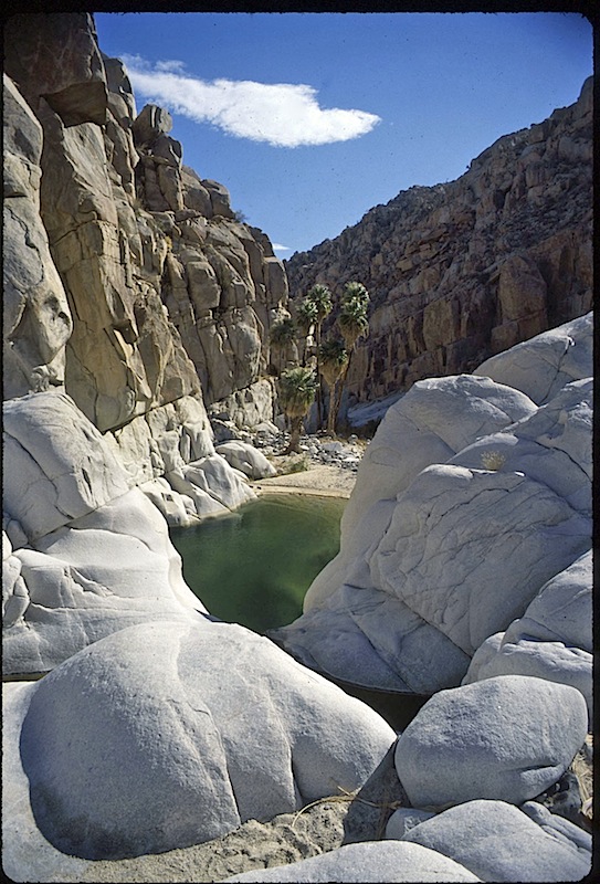
The canyon route was very dangerous for pack animals and the padres riding on mules or donkeys. Many have hiked it and taken photos of the oasis palms
and water pools. I hiked maybe halfway up the canyon from the Gonzaga side.
1b) The newer route crosses Arroyo Santa Maria just outside the canyon's east end and climbs up to the north rim, staying out of the canyon as much as
possible and rejoins the other route about 1/4 mile below the end of the bulldozed road. Many have hiked it and a couple have motorcycled it, but it
is dangerous on a bike. I hiked about 2/3 of the way up from the Gonzaga side.
2) The cargo trail goes from Bahia San Luis Gonzaga (near Papa Fernandez') towards Mission San Fernando, passing to the north of Mission Santa Maria
and joins the auto road (also El Camino Real route) about 3.5 miles west of the mission/ 11 miles east of Santa Ynez. Baja Bucko has been on it by
mule all the way to Gonzaga and back to Santa Ynez. Others have hiked about half of it from the Gonzaga side to an oasis where Baja Bucko hid a
GeoCache in 2001.
[Edited on 12-9-2014 by David K]
|
|
|
David K
Honored Nomad
Posts: 65562
Registered: 8-30-2002
Location: San Diego County
Member Is Online
Mood: Have Baja Fever
|
|
| Quote: Originally posted by TMW | David K posted a write up that Norm Christie did from a Backpacking trip from Hwy 1 KM187 near Jaraguay in 1993. The last three editions of the Baja
Almanac show a trail but that is not the way Christie went. In fact I've looked for a trail several times around that area off Hwy 1 and did not find
one.
[Edited on 12-8-2014 by TMW] |
Here is Norm's article (by the way he is a Baja Nomad 'RockMan'). He got his east and west mixed up, but otherwise describes going down the Jesuit
Camino Real to the canyon bottom and out to Punta Final:
On the morning of October 20, we cleaned our campsite and packed up for the last leg of our hike toward Bahia Gonzaga. Our local guide,
Prieto, told us that the main canyon downstream had several impassable areas of deep pools flanked by vertical smooth awls of granite, so we hiked up
above the canyon, on its north rim, along the remnant of the old Camino Real. This involved climbing slightly to a maximum elevation of 1375 feet (the
west end of the bulldozed trail) and proceeding for about a half mile. Along this stretch we observed several rocks with petroglyphs. We then returned
to the floor of the canyon (675 feet) where there was still water. As we proceeded westward, the canyon became wilder and sandier. Reaching the
beginning of the large alluvial fan at about 575 feet elevation, there was no sign of surface water; it was now flowing under the sand. We walked
about another mile before arriving at our previously arranged meeting site with a couple of vehicles (with ice chests full of notably cool
refreshments) and proceeded on wheels to Punta Final where resident friends were preparing a welcome back dinner.
|
|
|
4x4abc
Ultra Nomad
Posts: 4455
Registered: 4-24-2009
Location: La Paz, BCS
Member Is Offline
Mood: happy - always
|
|
I have hiked St. Maria canyon at least 30 times over the years - a beautiful day trip (start before sunrise and you'll make it in one day in and out).
Mostly I have taken the easy route connecting to the end of the bulldozed trail (right where the petroglyphs are). I have always called it the indian
trail. If you find the trail portions on the mesas, it's an easy trip - if you have to stay in the sand of the canyon, it's harder.
Many times I have followed the entire canyon (not going up to the petroglyph area). Some spots look impassable at first - but if you keep your eyes
peeled, you'll find easy routes over the cliffs. The toughest is the one at the large pool.
The Mission Trail above the canyon actually takes more time as the starting point is more east than the starting point indian trail. I have cleared a
drivable route about 2 miles east of the point where the Camino Real crosses the canyon from Las Palmitas. On 2 occasions while hiking the CR, we have
encountered gale force winds that knocked us onto our knees.
Harald Pietschmann
|
|
|
David K
Honored Nomad
Posts: 65562
Registered: 8-30-2002
Location: San Diego County
Member Is Online
Mood: Have Baja Fever
|
|
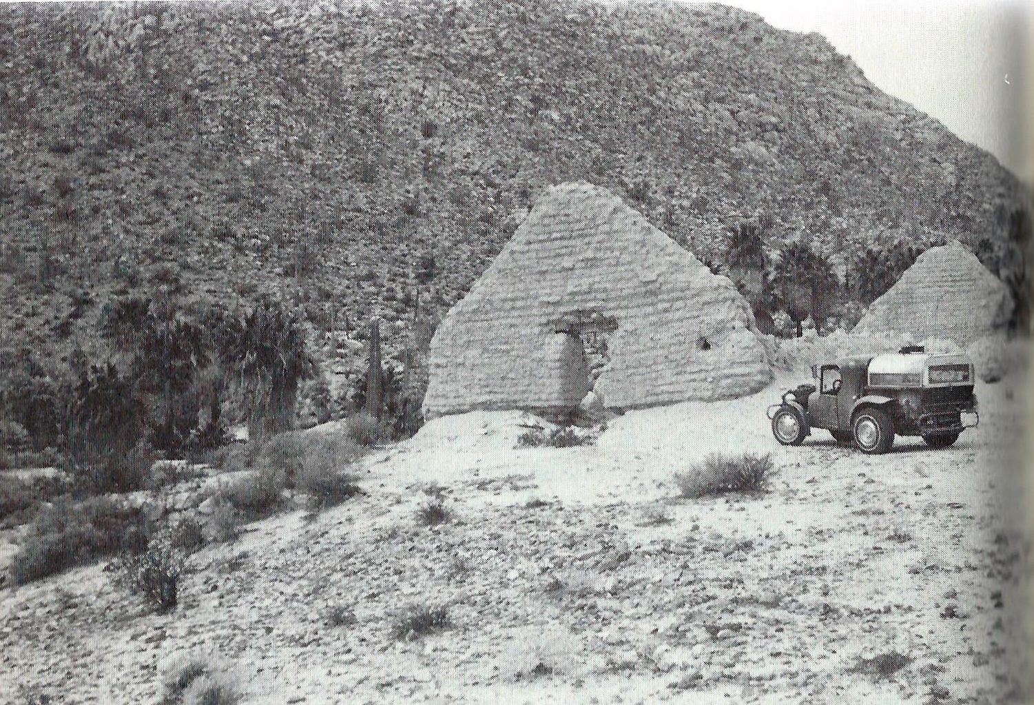
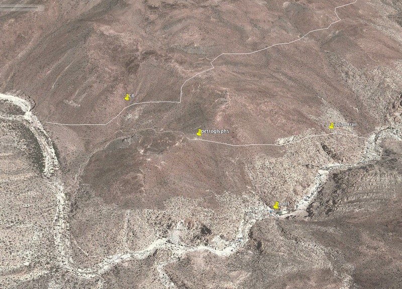
OK great, you know them both well. Looking at you satellite image above, there is a switchback trail that goes from the bulldozed road up the side of
the hill to near your pin 'CR'.
Here's an photo taken from Doug's plane of the same area in your sat images, but looking east... you can easily see the Indian Trail drop towards the
canyon bottom from the end of the bulldozed road...

Here's a photo of one of the petros along the 'Indian Trail' (Jesuit Camino Real)...

|
|
|
| Pages:
1
..
4
5
6
7 |


