| Pages:
1
..
4
5
6
7
8 |
The squarecircle
Nomad
 
Posts: 173
Registered: 11-28-2004
Location: El Cajon
Member Is Offline
Mood: 'Baja Feeling'
|
|
Quote: Originally posted by The squarecircle  | Quote: Originally posted by David K  | Quote: Originally posted by TMW  | I just got off the phone with Roy (The Squarecircle) and he wants to put a group together to investigate summit#3. I suggested the weekend of May 30,
but I'm open to other dates.
Anyone interested? 4x4ABC, Fernwell, DK. |
Maybe... it is the weekend after Memorial Day (May 25), when we traditionally take our first trip of the season to Shell Island. Sadly, the moon is in
quarter phase, meaning no big high and low tides. |
Greetings All >>>> It
has been about 30 years since I have been into "Cowboy Canyon" and the shack at the lower end of #3 summit. Back then the idea was to complete the
route with a 4X4 trail past the shack and up the mountain to M3. It would have been another way out of Desierto. With all the new interest in the pole
line road, this could be an interesting adventure. Have been at the lower shack several times both from the top and lower side. It is not an easy
blaze thru>>Maybe 100 yds. mas/menos.>>> Are there any adventurous Nomads to go there and take a look???? Best regards, sq.[/rquote
Greetings All, >>>> Need to BUMP this UP!!!! >>>> There appears to be more interest now in that area of:
>>>> Isabel Canyon-- EL Mano-- Laguna Hanson. >>>> Regards, sq.
|
|
|
|
TMW
Select Nomad
      
Posts: 10659
Registered: 9-1-2003
Location: Bakersfield, CA
Member Is Offline
|
|
After this weekend I'm good for anytime. I talked to Roy (Sq) yesterday and he is ready.
Who else? When can you make it.
David K
Emerson
|
|
|
Emerson
Junior Nomad

Posts: 42
Registered: 6-24-2013
Member Is Offline
|
|
Lets do it.
May 29-30-31?
|
|
|
PaulW
Ultra Nomad
    
Posts: 3113
Registered: 5-21-2013
Member Is Offline
|
|
Some thoughts:
The Mexicali route Hwy 5 should be OK when heading for the PLR. You will be on the race track from the wells south in AG for a bit, but then keep
right and get off the race track. Buy gas at Km 31.
We are all betting the race track will be revised where the flooding is, but that supposedly is north of the wells.
Beware there are no reports for Jaquegel and if it received half as much rain as parts north then there will be problems getting through. Even with no
flooding that would be a pretty slow way to get to the 3 summits.
The long route would be to head for the 3 summits would be from Valley Trinidad or Indepencia. Buy gas again in Trinidad. No reports of flooding in
that region. Adds more time? for the trip. Hwy 5 then hwy 3. Not a good way during prerunning or race day.
Waiting until after the race and there will be good road condition reports and no conflict with racers.
|
|
|
David K
Honored Nomad
        
Posts: 65397
Registered: 8-30-2002
Location: San Diego County
Member Is Offline
Mood: Have Baja Fever
|
|
Here's my thinking... going to Baja is not hard, but it is also no small event considering getting time off work or getting work to pay for the
trip... IF we go down there to SEE if Canyon #3 (Cañon de Jamau) is passable from the Y on the Pole Line Road to the top of the sierra... IS there
some other activity planned?
A) Go Up #3 if we can, and then back down #2 (Sáiz) to the Pole Line Road?
B) Go Up #2 (Sáiz) and back down #1 (Portezuelo de Jamau/ PLR)?
C) Don't come back down and head to Hwy. 3 and dinner in Ensenada?
D) Come back down and spend more time looking for insulators and other 'trash' from 1942?
E) Try some more to find Melchior Diaz' Grave? There is one more wash south of Arroyo D or see if we can drive up to the divide from the east side,
the way Walter Henderson walked it?
You see there's ENDLESS exploration potential in this peninsula! SO MUCH BAJA... SO LITTLE TIME!
|
|
|
TMW
Select Nomad
      
Posts: 10659
Registered: 9-1-2003
Location: Bakersfield, CA
Member Is Offline
|
|
So when do you want to go do A,B,C,D, and E or F.
|
|
|
David K
Honored Nomad
        
Posts: 65397
Registered: 8-30-2002
Location: San Diego County
Member Is Offline
Mood: Have Baja Fever
|
|
I am all for F! 
Seriously, it rained again last night/this morning here in 'drought' land... the third wet Friday in a row!!! While it thrills me to no end to have it
rain so much in May (first time in my life, perhaps), it also postpones or prevents my income 'stream' of installing water-saving irrigation systems.
No money, no Baja. For the first time in ages, this Memorial Day weekend will be a 'stay-cation' for Baja Angel and I and no typical trip to the San
Felipe area.
|
|
|
Emerson
Junior Nomad

Posts: 42
Registered: 6-24-2013
Member Is Offline
|
|
Well, It all depends if we can make it thru Summit #3, if we do, or not, depending on how tired we are we can decide to go a summit loop and explore
the PLR further; or if tired, dinner at Ensenada is always good; flexibility is our friend.
|
|
|
The squarecircle
Nomad
 
Posts: 173
Registered: 11-28-2004
Location: El Cajon
Member Is Offline
Mood: 'Baja Feeling'
|
|
Quote: Originally posted by Emerson  | | Well, It all depends if we can make it thru Summit #3, if we do, or not, depending on how tired we are we can decide to go a summit loop and explore
the PLR further; or if tired, dinner at Ensenada is always good; flexibility is our friend. |
Greetings ALL, >>> Cowboy Canyon (#3 Summit) route might be impassable unless local ranchers have made some improvements, but then
4x4ABC AND Fernwell might want to give it a try! Surprising there is no comment from them. Those two guys with Merc "G" Wagons are pretty much
unstoppable! However this route up #3 Summit may be just a little bit to much!!! >>>> Two quick ways into the Cowboy house
>>>> 1. La Ventana running PLR backwards ie. E.To W. 2. Laguna Salada thu El Pozzo Junction to the base of Summit Road >>>>
(A) Fun ride would be the Arroyo Grande to PLR (B) Longer and sennic route to PLR would be E.J. Heroes De La Independencia/Trinidad route if not
blocked with new fencing without gates. >>>>Once we are moving, there is no hurry, after all we are in Mexico,right? >>>>Gas
up in Heroes or Trinidad. Not so sure about gas a La Ventana now!!! Going up #2 Saiz is quick with dinner in Ensenada works. >>>> What
say you??? Regards, sq.
|
|
|
David K
Honored Nomad
        
Posts: 65397
Registered: 8-30-2002
Location: San Diego County
Member Is Offline
Mood: Have Baja Fever
|
|
Quote: Originally posted by The squarecircle  | Quote: Originally posted by Emerson  | | Well, It all depends if we can make it thru Summit #3, if we do, or not, depending on how tired we are we can decide to go a summit loop and explore
the PLR further; or if tired, dinner at Ensenada is always good; flexibility is our friend. |
Greetings ALL, >>> Cowboy Canyon (#3 Summit) route might be impassable unless local ranchers have made some improvements, but then
4x4ABC AND Fernwell might want to give it a try! Surprising there is no comment from them. Those two guys with Merc "G" Wagons are pretty much
unstoppable! However this route up #3 Summit may be just a little bit to much!!! >>>> Two quick ways into the Cowboy house
>>>> 1. La Ventana running PLR backwards ie. E.To W. 2. Laguna Salada thu El Pozzo Junction to the base of Summit Road >>>>
(A) Fun ride would be the Arroyo Grande to PLR (B) Longer and sennic route to PLR would be E.J. Heroes De La Independencia/Trinidad route if not
blocked with new fencing without gates. >>>>Once we are moving, there is no hurry, after all we are in Mexico,right? >>>>Gas
up in Heroes or Trinidad. Not so sure about gas a La Ventana now!!! Going up #2 Saiz is quick with dinner in Ensenada works. >>>> What
say you??? Regards, sq. |
Fun plans! 
"2. Laguna Salada thu El Pozzo Junction to the base of Summit Road"
Interesting spelling for COHABUZO JUNCTION!  works for me! works for me!
As Bernie used to say: "No Hurry, no worry"! 
In reviewing Gulick's book on Rancho Jamau (in Canyon #3, photo of shack posted above), page 80 Lower Ca Guidebook 4th edition, starting at the Pole
Line Road "Left at Y" point on our trip last Easter:
A road to left ends after 0.8 mi. A trail continues a mile further to JAMAU, cattle camp occupied in winter.
This may put that shack further up the canyon than I presumed, and may be where Roy's Cowboy shack was he hiked to in the 80's?
Let me do a Google Earth map. Now, Gulick had to estimate the 1 mile hike after parking his Willys Jeep Wagon... so a little flexibility on that
distance, but Gulick was an engineer and strived to be accurate.
|
|
|
David K
Honored Nomad
        
Posts: 65397
Registered: 8-30-2002
Location: San Diego County
Member Is Offline
Mood: Have Baja Fever
|
|
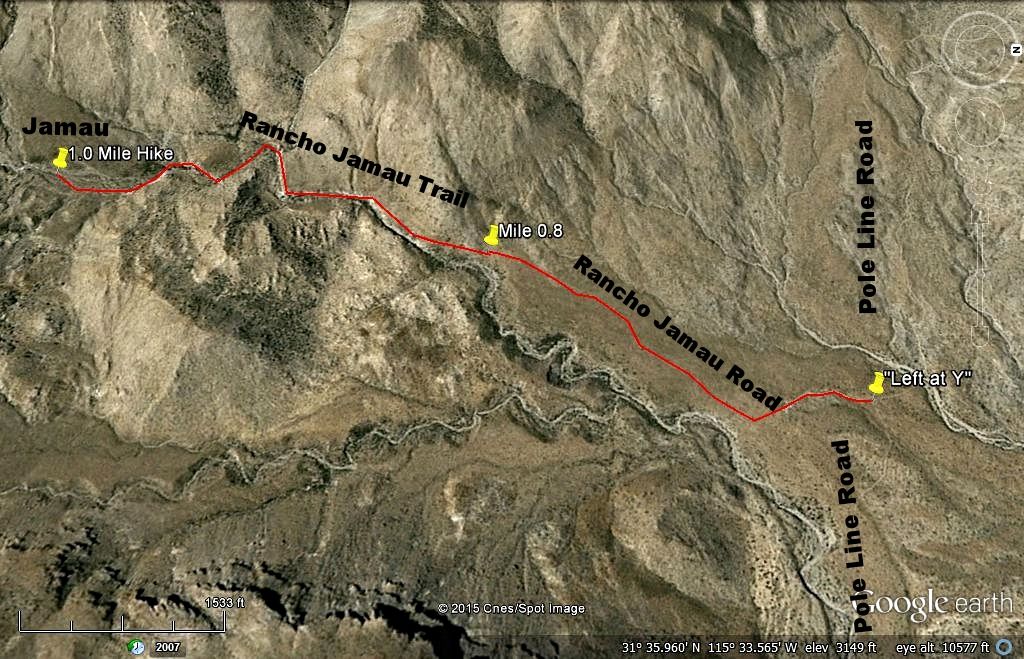
Interesting, so the shack in Gulick's photo is inside the canyon, and on Google Earth it is at the END of the road coming down from the mountain top.
The road going up, from the Pole Line Road in 1960 as it seems to today, ends at the mouth of the canyon, at Mile 0.8.
The 1 mile foot trail to the shack is the quest of The squarecircle, to see if it is an auto road now, as shown on the Mexican topo map.
This map is facing WEST (north on the right) to show the most detail of the road and trail:

The shack is rancho or cattle camp 'Jamau' in the guidebook, and labeled on the map. Not to be confused with the other Jamau on the Summit Road (#1)
used by SCORE.
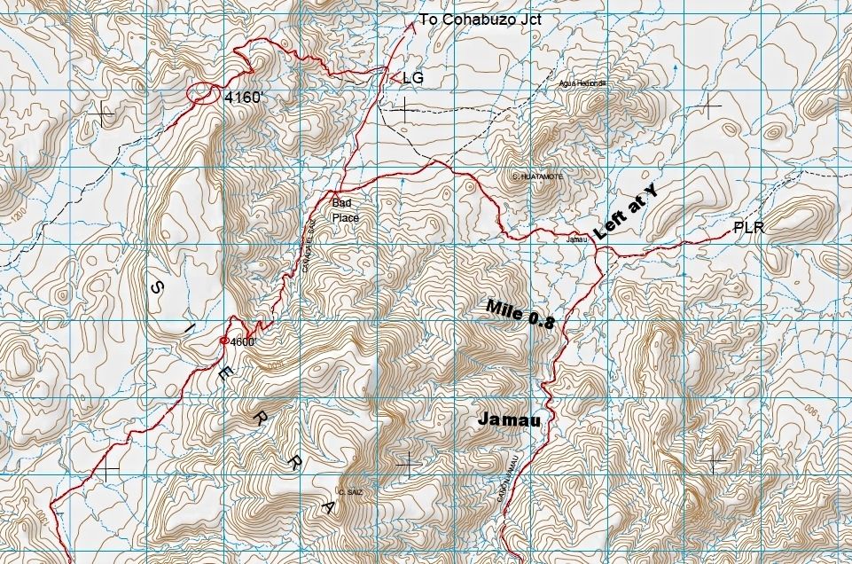
Here is the topo map with notes added:


[Edited on 5-24-2015 by David K]
|
|
|
David K
Honored Nomad
        
Posts: 65397
Registered: 8-30-2002
Location: San Diego County
Member Is Offline
Mood: Have Baja Fever
|
|
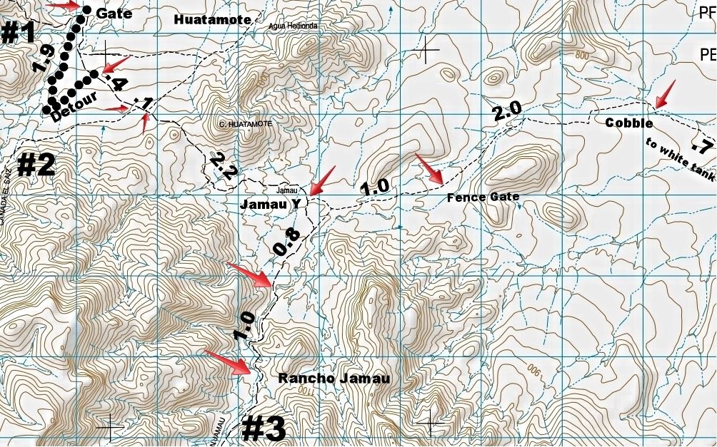
Yes, thank you! New maps made.
|
|
|
PaulW
Ultra Nomad
    
Posts: 3113
Registered: 5-21-2013
Member Is Offline
|
|
Roy,
Been looking for El Pozzo. Can you tell me where you saw the place on a map? Otherwise wher did the name come from? Thanks, Paul
=======
|
|
|
David K
Honored Nomad
        
Posts: 65397
Registered: 8-30-2002
Location: San Diego County
Member Is Offline
Mood: Have Baja Fever
|
|
Quote: Originally posted by PaulW  | Roy,
Been looking for El Pozzo. Can you tell me where you saw the place on a map? Otherwise wher did the name come from? Thanks, Paul
=======
|
Paul, you missed my post earlier today to Roy? El Pozzo Junction is his squarecircle way of saying Cohabuzo Junction.  
|
|
|
PaulW
Ultra Nomad
    
Posts: 3113
Registered: 5-21-2013
Member Is Offline
|
|
David,
You made reference to Gulick calling Canada Enmedio to be the same as Arroyo Jamau. Can you explain?
Gulick incorrectly called Rancho El Alamito located near the summit of #3. Can you enlighten me about that error Since Alamito is the arroyo leading
to summit #1.
It is true there is an occupied rancho just south of summit #1, and I would be tempted to call it Rancho Alamito.
Thanks, Paul
|
|
|
PaulW
Ultra Nomad
    
Posts: 3113
Registered: 5-21-2013
Member Is Offline
|
|
Travelers heading for the 3 summit investigation should be aware of the fueling situation.
Heading south on Hwy 5 the last PMEX fuel is at Km 31. La Ventana at Km105 may have enough for one bike, but no more than that. So that means by
filling up at KM31 you will have enough to do the Pole Line road and get to valley Trinidad, but any side trips for exploration means you will need
extra gas cans on board.
From the south side of the 3 summits get fuel at Valley Trinidad PMEX. Its true you can refuel at Indepencia but the fuel lady does it from jugs and
the process is painfully slow, and the cost is high.
Figure your distances: Mx5/Mx3 junction is km141on 5 & km195 on 3. Trinidad is km120. On Mx 3 the exit to get to Jamau biker place is km109.
Paul
|
|
|
David K
Honored Nomad
        
Posts: 65397
Registered: 8-30-2002
Location: San Diego County
Member Is Offline
Mood: Have Baja Fever
|
|
Quote: Originally posted by PaulW  | David,
You made reference to Gulick calling Canada Enmedio to be the same as Arroyo Jamau. Can you explain?
Gulick incorrectly called Rancho El Alamito located near the summit of #3. Can you enlighten me about that error Since Alamito is the arroyo leading
to summit #1.
It is true there is an occupied rancho just south of summit #1, and I would be tempted to call it Rancho Alamito.
Thanks, Paul |
Hi Paul,
The name Jamau is applied to multiple locations and features, probably causes most of the confusion?
Then (long after Gulick mapped Baja) the Mexican government produces topo maps of Baja, and sadly uses the wrong name for many features! Because it is
a government document, many believe it to be correct or over-rides Gulick's names.
Now for your questions...
No map at the time had an arroyo named 'Enmedio', so what ever base map Gulick used called in Jamau or he believed that wash (Enmedio) was downstream
from Cañon Jamau.
Incorrectly Alamito?
*Arroyo Alamito is the west flowing wash the summit road uses from the Portezuelo de Jamau (peninsular divide/ top of #1), per the topo (and only map
with that name).
*A ranch in that wash (Gulick photo) was called El Alamito (by the ranch occupants, probably?), Gulick does not have the ranch or arroyo shown on his
map.
*The photo caption calls it El Alamito, and the location is correct, west of the summit, in Arroyo Alamito.
*The topo has an abandoned El Alamito there, as well. (2003 Almanac)
I think Gulick was correct.
Ken Cooke has been calling the wash east of/ bottom of Portezuelo de Jamau "Alamito", but that is actually El Sáiz arroyo.
There was no ranch south or anywhere at the foot of Summit #1... again this is Arroyo or Cañon el Sáiz, not Alamito on the east side of the range.
If it helps, I can produce the maps with the names pointed out. I have Map 8 of the 2003 Alamanc in front of me, as well as Map 3 & 4 of the 2009
Almanac.
[Edited on 5-24-2015 by David K]
|
|
|
The squarecircle
Nomad
 
Posts: 173
Registered: 11-28-2004
Location: El Cajon
Member Is Offline
Mood: 'Baja Feeling'
|
|
Thank you PaulW and David K for correcting me on the EL Pozzo vs. Cohabuzo misnomer. I don't see Cohabuzo Junction on my latest Baja California
Almanac. Wrong statement from failing memory! Excellent info on gas availability in those areas, thank you. Are you planning on making this trek?
>>>>> Best Regards, sq.
|
|
|
David K
Honored Nomad
        
Posts: 65397
Registered: 8-30-2002
Location: San Diego County
Member Is Offline
Mood: Have Baja Fever
|
|
Quote: Originally posted by The squarecircle  | | Thank you PaulW and David K for correcting me on the EL Pozzo vs. Cohabuzo misnomer. I don't see Cohabuzo Junction on my latest Baja California
Almanac. Wrong statement from failing memory! Excellent info on gas availability in those areas, thank you. Are you planning on making this trek?
>>>>> Best Regards, sq. |
It isn't on an Almanac... SCORE created the name back in the 70's. The AAA maps back then called a nearby mountain Cohabuzo, so that's how SCORE got
the name.
|
|
|
PaulW
Ultra Nomad
    
Posts: 3113
Registered: 5-21-2013
Member Is Offline
|
|
Three summits summary
Well this thread is all about a study of the three summits. Let me summarize what we all found.
Summit #1 is the north summit and is being used all the time. I now has a new section to bypass of the washout encountered for the 2012 San Felipe
250.
Most interesting summits are #2 and #3.
Summit #2 is the middle summit and is named Saiz after the Arroyo coming up from the north. In 1995 SCORE proposed to do a loop using both #1 and #2,
but they got to many complaints of difficulty so the race was moved and #2 was not used. The Siaz summit was pre-run at that time by TMW using trucks
and MC. In 2003 Ken drove it going south and had a hard time. No more recent reports.Location is 31 35.92, -115 36.6, el4600'.
Summit #3 is the south summit and is called Jamau. The track goes to/from the Pole Line Road over the top to the area near Indepencia. At this time it
is believed unpassable. In 1972 and 1972 the complete pass was used for the Tecate Enduro, a hard core Biker event. In 1963-64 A MC club made it all
the way, but they had to carry their bikes over/across drop-offs. Roy found it impassable in 1984. In the early 90s TMW on MC found steep drop-offs
and did not continue. In 2004 Kens Jeepers turned around. No more recent reports.
===========
I keep learning all the time.
Found out the source of name Cohabuzo form a summit on an old AAA map
Located the abandoned rancho in canyon Alamito. Plotted the location of the occupied rancho at the top of summit #1. Got up to speed on Guilck’s
Rancho Alamito. Located a bunch of Jamau’s as follows:
For sure we have lots of Jamau's
* The most common one the public is aware of it the biker lodging place near Nuevo Junction. On Highway 3 there is a sign at Km 109 directing
travelers to that place. I have stayed there several times at 31 29.694, -115 42 296, el 3242’
* Then we have summit #1 that is most commonly used for SCORE races. The historical name for that summit is "Portezuelo de Jamau". The topo would call
the summit EL Alamito after the name of the canyon leading to the summit from the southwest. At 31 37.631, -115 36.624, el4160’
* Canyon Jamau road Summit at 31 33.449, -115 34.6 Elevation ~5300’
* Then we have Arroyo Jamau shown on the Topo leading to the summit from the southwest. And we all are calling that summit Jamau (#3). Gulick probably
called the west approach Canada Enmedio? In 1959.
* Then we have the location on the Topo at the intersection of the pole line road and the turn south to the Jamau summit. And the Topo labels that
place as Jamau.
* Then on the north side of Summit #3 we have the cattle camp about a mile south of the Pole Line road on the track leading to the Jamau summit. We
are calling that place “Rancho Jamau”(1960) or the “Jamau cattle camp”. Near 31 36.5, -115 35.9
* Cerro Jamau 31 33.0, -115 35.7 Approximately.
I discovered the track on the Topo for Canyon El Alamito is the track in the valley with all the locked gates. The SCORE track is west of the topo
track on the side of the hill and it has no locked gates. That track has a few hard places with loose boulders.
I discovered the track on the south side of Siaz summit (#2) connects to the track from the Jamau summit (#3) by way of canyon La Pintada and canyon
el Cantilar. The tracks show up on GE.
Yes, IMO it is correct that there is no canyon or wash on the north/east side of Purtozelo De Jamau. The road in all its variants just goes thru a
small wash then down the face of the mountain until it reaches Canyon/Arroyo Siaz. However a study of the topo indicates the water drainage from the
summit does end up in Siaz. And the easiest water flow did use the race road in some places on the way to the bottom.
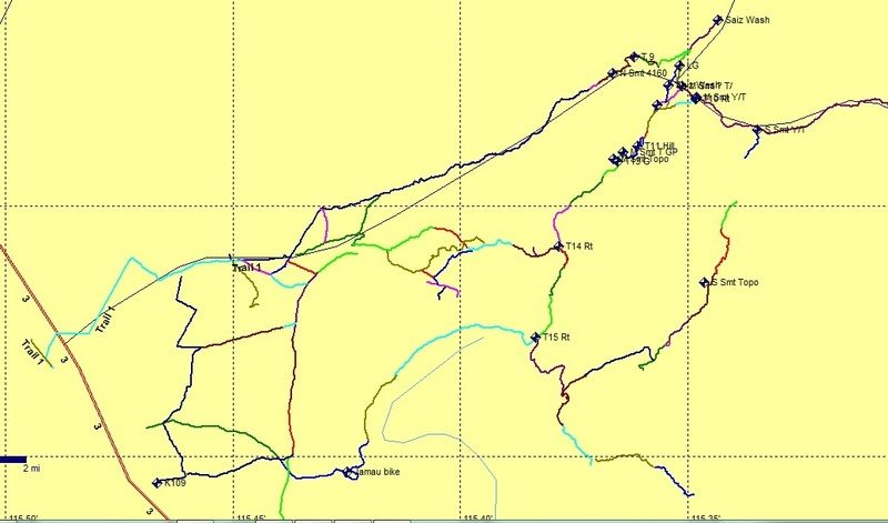
Look at all the roads I plotted from GE

The above is my rainy day exercise.
[Edited on 5-25-2015 by PaulW]
|
|
|
| Pages:
1
..
4
5
6
7
8 |

