| Pages:
1
..
5
6
7
8
9
..
25 |
David K
Honored Nomad
        
Posts: 65412
Registered: 8-30-2002
Location: San Diego County
Member Is Offline
Mood: Have Baja Fever
|
|
The actual part in the wash (arroyo) was less than 3 miles (orig. point 6 to point 12, at Salsipuedes jcn.).
Now, if he is riding his bike to Bahía de los Angeles from there, that's close to 60 miles from the trail, and over 30 miles of that is paved on the
route he is using.
Typo fixed, thank you Woody! There is an accent on that i too! 
[Edited on 12-31-2013 by David K]
|
|
|
woody with a view
PITA Nomad
      
Posts: 15940
Registered: 11-8-2004
Location: Looking at the Coronado Islands
Member Is Offline
Mood: Everchangin'
|
|
| Quote: | Originally posted by David K
Now, if he is riding his bike to Bahiia de los Angeles from there, that's close to 60 miles from the trail, and over 30 miles of that is paved on the
route he is using. |
anyone seen the spelling cop?
|
|
|
Mark_BC
Nomad
 
Posts: 137
Registered: 12-1-2013
Location: Vancouver, BC
Member Is Offline
|
|
Hey guys I made it back. It's really beautiful up there, that canyon is unlike anywhere I've seen. It was pretty rough with a few cliffs and rocks to
lower my gear down. I hiked the last 3 km on that wash to the beginnings of the pools and there was no way I'd be able to get through. The terrain is
the big granite rocks like at Catavina, but vertical. I could have possibly explored a little further if I wanted to hike over hills of giant boulders
but decided it was too dangerous to do by myself. I also wasnt sure if my spot was getting through. With multiple people and some proper climbing gear
you could probably go further down. Then I backtracked out and headed back via desangano and then the highway. Last night I didn't get much sleep with
a pack of coyotes tipping all around me.
So this place is as rough to get in as get out. It seems the only other entry point besides la botica is that other long wash that goes south and
heads to the west of laguna seca, over the hills. We checked that out from afar last June, it looks passable. But I'd like to check that out by foot
first if anyone is in the area and wants to go explore. Then if the recon checks out ok we could start planning the next attempt... How far up did you
get with the quads, Larry?
|
|
|
Mark_BC
Nomad
 
Posts: 137
Registered: 12-1-2013
Location: Vancouver, BC
Member Is Offline
|
|
Hey mark you got your id sorted out! I can receive emails here but not send, hotmail wants to verify its me by sending me a code on my phone but I
have no coverage here... So just send me a p2p message on this site and I can access those. Are you still planning to come down that weekend? I'll
have to check through my emails, not sure if I'm needed at work.
The bike's ok, just a few minor dings.
|
|
|
woody with a view
PITA Nomad
      
Posts: 15940
Registered: 11-8-2004
Location: Looking at the Coronado Islands
Member Is Offline
Mood: Everchangin'
|
|
sweet!
|
|
|
mtgoat666
Platinum Nomad
       
Posts: 20396
Registered: 9-16-2006
Location: San Diego
Member Is Offline
Mood: Hot n spicy
|
|
| Quote: | Originally posted by Mark_BC
Hey guys I made it back. It's really beautiful up there, that canyon is unlike anywhere I've seen. It was pretty rough with a few cliffs and rocks to
lower my gear down. I hiked the last 3 km on that wash to the beginnings of the pools and there was no way I'd be able to get through. The terrain is
the big granite rocks like at Catavina, but vertical. I could have possibly explored a little further if I wanted to hike over hills of giant boulders
but decided it was too dangerous to do by myself. I also wasnt sure if my spot was getting through. With multiple people and some proper climbing gear
you could probably go further down. Then I backtracked out and headed back via desangano and then the highway. Last night I didn't get much sleep with
a pack of coyotes tipping all around me.
So this place is as rough to get in as get out. It seems the only other entry point besides la botica is that other long wash that goes south and
heads to the west of laguna seca, over the hills. We checked that out from afar last June, it looks passable. But I'd like to check that out by foot
first if anyone is in the area and wants to go explore. Then if the recon checks out ok we could start planning the next attempt... How far up did you
get with the quads, Larry? |
Rocks rule! So to speak.
Did the ponds look like they hold permanent water? Was it drinkable? (i.e. not too salty)
|
|
|
motoged
Elite Nomad
     
Posts: 6481
Registered: 7-31-2006
Location: Kamloops, BC
Member Is Offline
Mood: Gettin' Better
|
|
Mother Earth wins again....
Salsipuedes - get out while you can.
Don't believe everything you think....
|
|
|
Mark_BC
Nomad
 
Posts: 137
Registered: 12-1-2013
Location: Vancouver, BC
Member Is Offline
|
|
| Quote: | Originally posted by mtgoat666
Rocks rule! So to speak.
Did the ponds look like they hold permanent water? Was it drinkable? (i.e. not too salty) |
I would guess not. They were beginning to dry out with mud caking, and it had rained only weeks before. It would be good to know this for sure though
since if you went in from the Laguna Seca side that would be a good place to recharge your water supplies. It's hard to say, they go on for a couple
km and I only encountered the first one.
It was green and bubbling so probably not drinkable without further filtering. The uppermost part of the wash is a cattle grazing area and there is
dung and cattle everywhere in an open stream. That is what is feeding it.
The good part is that it's "easy" to hike into that area. The upper 10 km of that road in is rough but typical terrain for a jeep. Then it's only a
few km hike in from there, you could easily do it in a day from where you park your jeep. Just a few rocky areas you'd have to negotiate but with only
a backpack and multiple people it should be fairly straightforward. What the terrain gets like after that first pool would be interesting to know, but
based on Google Earth it looks like it gets pretty crazy until it turns north into the main wash.
|
|
|
larryC
Super Nomad
   
Posts: 1499
Registered: 8-11-2008
Location: BoLA
Member Is Offline
|
|
| Quote: | Originally posted by Mark_BC
Hey guys I made it back. It's really beautiful up there, that canyon is unlike anywhere I've seen. It was pretty rough with a few cliffs and rocks to
lower my gear down. I hiked the last 3 km on that wash to the beginnings of the pools and there was no way I'd be able to get through. The terrain is
the big granite rocks like at Catavina, but vertical. I could have possibly explored a little further if I wanted to hike over hills of giant boulders
but decided it was too dangerous to do by myself. I also wasnt sure if my spot was getting through. With multiple people and some proper climbing gear
you could probably go further down. Then I backtracked out and headed back via desangano and then the highway. Last night I didn't get much sleep with
a pack of coyotes tipping all around me.
So this place is as rough to get in as get out. It seems the only other entry point besides la botica is that other long wash that goes south and
heads to the west of laguna seca, over the hills. We checked that out from afar last June, it looks passable. But I'd like to check that out by foot
first if anyone is in the area and wants to go explore. Then if the recon checks out ok we could start planning the next attempt... How far up did you
get with the quads, Larry? |
Mark
On the trip I was on in '04 we got about 12 miles up the canyon. On the 2010 trip the guys got all the way up to the dry lake, Botica dry lake for
want of a better name. I think the canyon you headed down (at the end of the road) goes on down into what ESGardener called La Asamblea. who knows
what the real name is. Up at the top of the canyon, along the road before you get to the ranchos there is a big granite ridge and right near there if
you hunt you will find another canyon entrance that might be an easier way in. Or it might not. the easiest way I found was by boat. Now that you have
seen that country doesn't it give you a lot of respect for what ES Gardeners crew was able to do 50 years ago?
Larry
Off grid, 12-190 watt evergreen solar panels on solar trackers, 2-3648 stacked Outback inverters, 610ah LiFePo4 48v battery bank, FM 60 and MX60
Outback charge controllers, X-240 Outback transformer for 240v from inverters, 6500 watt Kubota diesel generator.
|
|
|
David K
Honored Nomad
        
Posts: 65412
Registered: 8-30-2002
Location: San Diego County
Member Is Offline
Mood: Have Baja Fever
|
|
It can be confusing when so many routes are discussed... According to Mark's Spot signals he was in a branch of Salsipuedes, and his final Spot before
turning back is where the wash he was going down met the main Salsipuedes (per the map name). The pin called 'Trail' is next to Mark's arroyo.
The road continues north, past where Mark entered the arroyo system and goes to the back side of that dark hill and meets a branch of La Asamblea
system (marked 'Road' on the following image).
Once in the La Asamblea system, you can go to the gulf or at least to where Salsipuedes joins La Asamblea a few miles from the gulf.
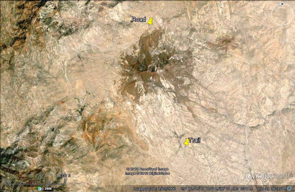
Edit: note scale bar on image... that is just over 1 mile long.
[Edited on 1-1-2014 by David K]
|
|
|
David K
Honored Nomad
        
Posts: 65412
Registered: 8-30-2002
Location: San Diego County
Member Is Offline
Mood: Have Baja Fever
|
|
Mark's Spots in Arroyo system
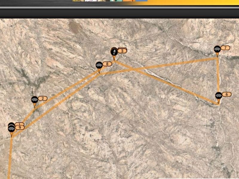
#1 & 9 on the above image is near the ranch road. #7 is where that arroyo meets the main Salsipuedes arroyo... originally was Spot 12, as drawn on
map...
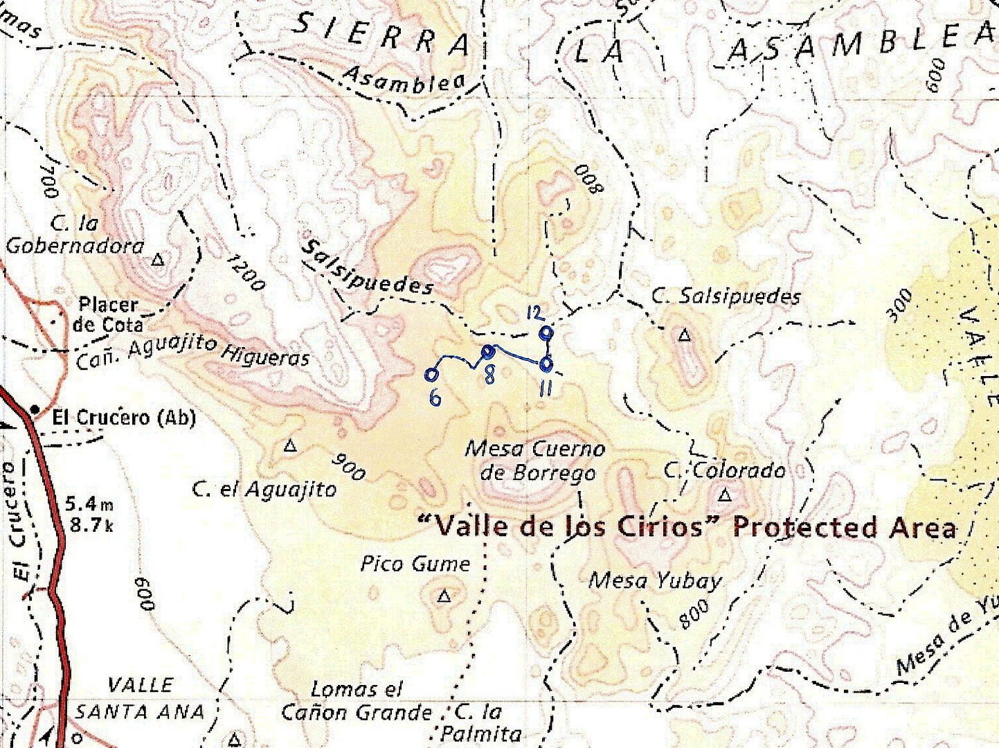
The ranch road continues north and meets with an arroyo that joins La Asamblea (note north flowing arroyo on map going into Arroyo la Asamblea).
Too bad Google Earth is still not at a high enough resolution to see boulders that can block progress.
Thanks for sharing your attempt with us Mark! BillB (the Rokon rider) is following this and has been rooting for your success too!
|
|
|
motoged
Elite Nomad
     
Posts: 6481
Registered: 7-31-2006
Location: Kamloops, BC
Member Is Offline
Mood: Gettin' Better
|
|
David,
Thank you for some great mapwork !
As a visual person, you have helped create a context for understanding this adventure.
And Mark,...congratulations on the adventure 
Don't believe everything you think....
|
|
|
Mark_BC
Nomad
 
Posts: 137
Registered: 12-1-2013
Location: Vancouver, BC
Member Is Offline
|
|
Actually I'm not sure that's drawn right on the Baja Almanac map. I started in the main Salsipuedes drainage, but the road follows it further, all the
way up to near its headwaters on that map. You will see a ranch at 29,16'33'' 114,2'53''. That is in the drainage. I turned off the road way before
that, at 29,15'37'' 114,1'17''. From there the wash leaves the route of the road and heads east-northeast. I rode that to the beginnings of the actual
canyon, at 29,15'43'' 114,1'6'' where I camped the first night in the canyon. From there I followed the main Salsipuedes drainage down, but it's in
the canyon from then on.
It was that evening that Jimmy the local rancher followed my tracks into the canyon and said hi. I was a bit startled and we spoke for a few minutes.
He said there are paintings on the other side (north west side?) of the big granite monument directly to the northwest of that spot. I didn't think it
was safe to go up alone. He said he was from a few kilometers up the road, and I asked if it was Asamblea and he said yes. He was friendly. In
hindsight I wish I had asked him if there was water there year round but I wasn't really prepared to just see him like that. I don't think he knows
much about the canyon downstream of his cattle because he said it should take two days to ride to the ocean! So I guess he's never been down to the
pools as far as I went. Interestingly down in that last section of wash before the pools, at the side of the channel, there is a bunch of black ABS
pipe that they use for moving water around. So someone has been there and tried to set up some kind of a water system.
Before the road goes to his ranch there is a Y which goes right off into Asamblea, down the wash a ways. I don't have the bandwidth right now to look
into the details of that but I remember looking before I came down and it looked pretty rocky most of the way. My concern would be, and was, if you go
a long ways down the canyon, like more than halfway in terms of time, and you've committed yourself to get to the ocean to find water, but you come
across some impassable obstacle, then what do you do. That is what Asamblea kind of looks like to me, it looks rough almost all the way down to the
junction with Salsipuedes. On the other hand Salsipuedes looks pretty easy once you get through the upper canyon. From the confluence at 29,16'46''
113,58'21'' it looks clear sailing all the way to the ocean except for that jumble of rocks 400 m to the north which looks passable. That's why I
would like to look into entering using that confluence at the coordinates in the previous sentence, and instead try from the wash that enters from the
south-east. That terrain is not the blocky granite boulders, it is your typical desert terrain. It doesn't look too bad. I'd enter from Laguna Seca
through the pass at 29,14'52'' 113,56'27'' which is actually lower in elevation than where I entered Salsipuedes canyon! But it should be scouted out
on foot first, a nice little overnight trip, if you can get a vehicle and drive up there.
Those granite boulder areas are really deceptive in Google Earth. Some sections that were totally indecipherable from GE were a breeze and others that
didn't look too bad were difficult or impassable. Because the rocks are vertical!
Yeah it's amazing what they did, considering all the technology and Google Earth we have now.
I got all the pics and video onto my computer. The pics are OK but there's some really great video.
|
|
|
DEVEAU
Nomad
 
Posts: 104
Registered: 11-29-2005
Member Is Offline
Mood: "WFO"
|
|
Mark, very impressive adventure. Love the story of meeting Jimmy.
I assume this is all North of Window Rock.
Chase Trucks? ??
We don\'t need no stinking chase trucks!
|
|
|
mtgoat666
Platinum Nomad
       
Posts: 20396
Registered: 9-16-2006
Location: San Diego
Member Is Offline
Mood: Hot n spicy
|
|
| Quote: | Originally posted by Mark_BC
Actually I'm not sure that's drawn right on the Baja Almanac map. I started in the main Salsipuedes drainage, but the road follows it further, all the
way up to near its headwaters on that map. You will see a ranch at 29,16'33'' 114,2'53''. That is in the drainage. I turned off the road way before
that, at 29,15'37'' 114,1'17''. From there the wash leaves the route of the road and heads east-northeast. I rode that to the beginnings of the actual
canyon, at 29,15'43'' 114,1'6'' where I camped the first night in the canyon. From there I followed the main Salsipuedes drainage down, but it's in
the canyon from then on.
It was that evening that Jimmy the local rancher followed my tracks into the canyon and said hi. I was a bit startled and we spoke for a few minutes.
He said there are paintings on the other side (north west side?) of the big granite monument directly to the northwest of that spot. I didn't think it
was safe to go up alone. He said he was from a few kilometers up the road, and I asked if it was Asamblea and he said yes. He was friendly. In
hindsight I wish I had asked him if there was water there year round but I wasn't really prepared to just see him like that. I don't think he knows
much about the canyon downstream of his cattle because he said it should take two days to ride to the ocean! So I guess he's never been down to the
pools as far as I went. Interestingly down in that last section of wash before the pools, at the side of the channel, there is a bunch of black ABS
pipe that they use for moving water around. So someone has been there and tried to set up some kind of a water system.
Before the road goes to his ranch there is a Y which goes right off into Asamblea, down the wash a ways. I don't have the bandwidth right now to look
into the details of that but I remember looking before I came down and it looked pretty rocky most of the way. My concern would be, and was, if you go
a long ways down the canyon, like more than halfway in terms of time, and you've committed yourself to get to the ocean to find water, but you come
across some impassable obstacle, then what do you do. That is what Asamblea kind of looks like to me, it looks rough almost all the way down to the
junction with Salsipuedes. On the other hand Salsipuedes looks pretty easy once you get through the upper canyon. From the confluence at 29,16'46''
113,58'21'' it looks clear sailing all the way to the ocean except for that jumble of rocks 400 m to the north which looks passable. That's why I
would like to look into entering using that confluence at the coordinates in the previous sentence, and instead try from the wash that enters from the
south-east. That terrain is not the blocky granite boulders, it is your typical desert terrain. It doesn't look too bad. I'd enter from Laguna Seca
through the pass at 29,14'52'' 113,56'27'' which is actually lower in elevation than where I entered Salsipuedes canyon! But it should be scouted out
on foot first, a nice little overnight trip, if you can get a vehicle and drive up there.
Those granite boulder areas are really deceptive in Google Earth. Some sections that were totally indecipherable from GE were a breeze and others that
didn't look too bad were difficult or impassable. Because the rocks are vertical!
Yeah it's amazing what they did, considering all the technology and Google Earth we have now.
I got all the pics and video onto my computer. The pics are OK but there's some really great video. |
The local ranchers probably know the way(s). Ditch the google earth and interview the local ranchers. There are caballeros been all over that country,
but would take time to track them down.
|
|
|
David K
Honored Nomad
        
Posts: 65412
Registered: 8-30-2002
Location: San Diego County
Member Is Offline
Mood: Have Baja Fever
|
|
| Quote: | Originally posted by Mark_BC
Actually I'm not sure that's drawn right on the Baja Almanac map. I started in the main Salsipuedes drainage, but the road follows it further, all the
way up to near its headwaters on that map. You will see a ranch at 29,16'33'' 114,2'53''. That is in the drainage. I turned off the road way before
that, at 29,15'37'' 114,1'17''. From there the wash leaves the route of the road and heads east-northeast. I rode that to the beginnings of the actual
canyon, at 29,15'43'' 114,1'6'' where I camped the first night in the canyon. From there I followed the main Salsipuedes drainage down, but it's in
the canyon from then on.
It was that evening that Jimmy the local rancher followed my tracks into the canyon and said hi. I was a bit startled and we spoke for a few minutes.
He said there are paintings on the other side (north west side?) of the big granite monument directly to the northwest of that spot. I didn't think it
was safe to go up alone. He said he was from a few kilometers up the road, and I asked if it was Asamblea and he said yes. He was friendly. In
hindsight I wish I had asked him if there was water there year round but I wasn't really prepared to just see him like that. I don't think he knows
much about the canyon downstream of his cattle because he said it should take two days to ride to the ocean! So I guess he's never been down to the
pools as far as I went. Interestingly down in that last section of wash before the pools, at the side of the channel, there is a bunch of black ABS
pipe that they use for moving water around. So someone has been there and tried to set up some kind of a water system.
Before the road goes to his ranch there is a Y which goes right off into Asamblea, down the wash a ways. I don't have the bandwidth right now to look
into the details of that but I remember looking before I came down and it looked pretty rocky most of the way. My concern would be, and was, if you go
a long ways down the canyon, like more than halfway in terms of time, and you've committed yourself to get to the ocean to find water, but you come
across some impassable obstacle, then what do you do. That is what Asamblea kind of looks like to me, it looks rough almost all the way down to the
junction with Salsipuedes. On the other hand Salsipuedes looks pretty easy once you get through the upper canyon. From the confluence at 29,16'46''
113,58'21'' it looks clear sailing all the way to the ocean except for that jumble of rocks 400 m to the north which looks passable. That's why I
would like to look into entering using that confluence at the coordinates in the previous sentence, and instead try from the wash that enters from the
south-east. That terrain is not the blocky granite boulders, it is your typical desert terrain. It doesn't look too bad. I'd enter from Laguna Seca
through the pass at 29,14'52'' 113,56'27'' which is actually lower in elevation than where I entered Salsipuedes canyon! But it should be scouted out
on foot first, a nice little overnight trip, if you can get a vehicle and drive up there.
Those granite boulder areas are really deceptive in Google Earth. Some sections that were totally indecipherable from GE were a breeze and others that
didn't look too bad were difficult or impassable. Because the rocks are vertical!
Yeah it's amazing what they did, considering all the technology and Google Earth we have now.
I got all the pics and video onto my computer. The pics are OK but there's some really great video. |
I think the Almanac shows Salsipuedes a bit off and the main route to the north, so I drew Mark's track in relationship to the Almanac's placement of
the Salsipuedes wash. In fact, Mark's Salsipuedes looks like the main one... Here are some satellite images with Mark's posted GPS waypoints and a
couple of his Spot points (M pin):
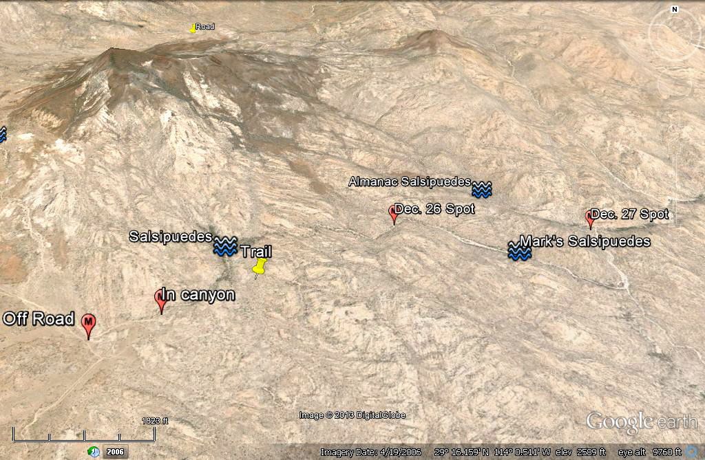
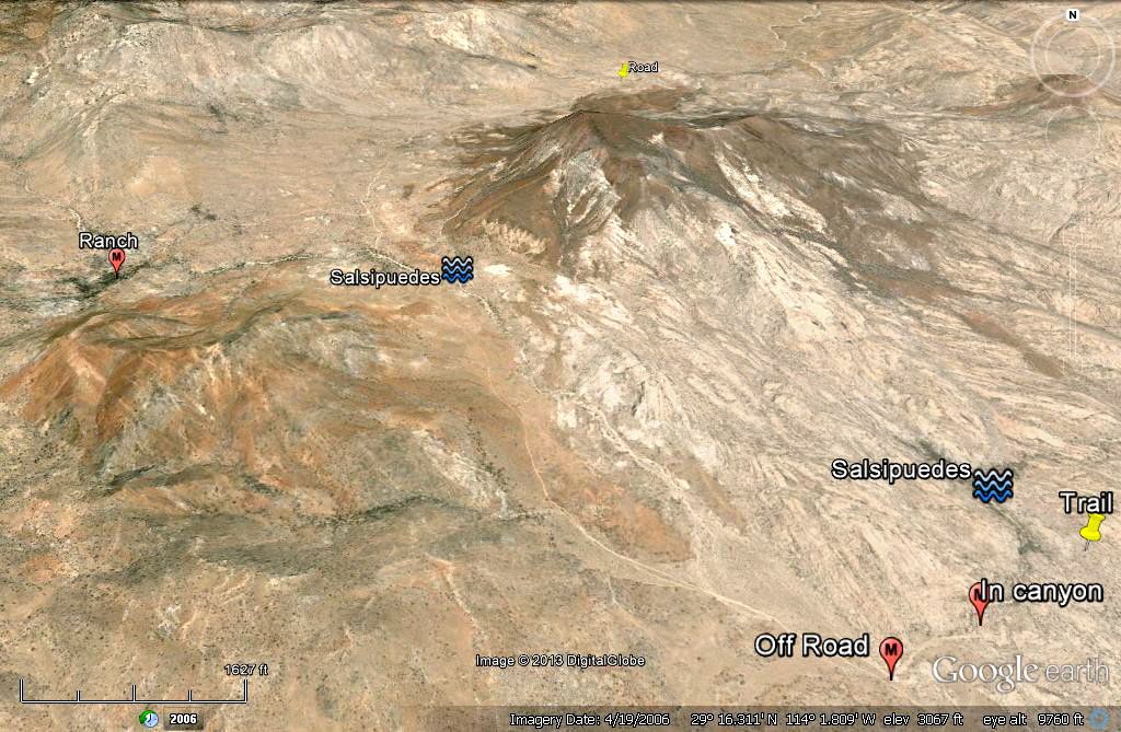
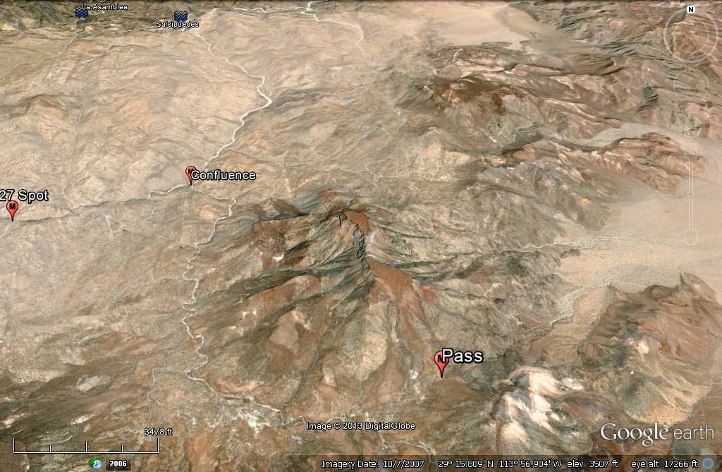
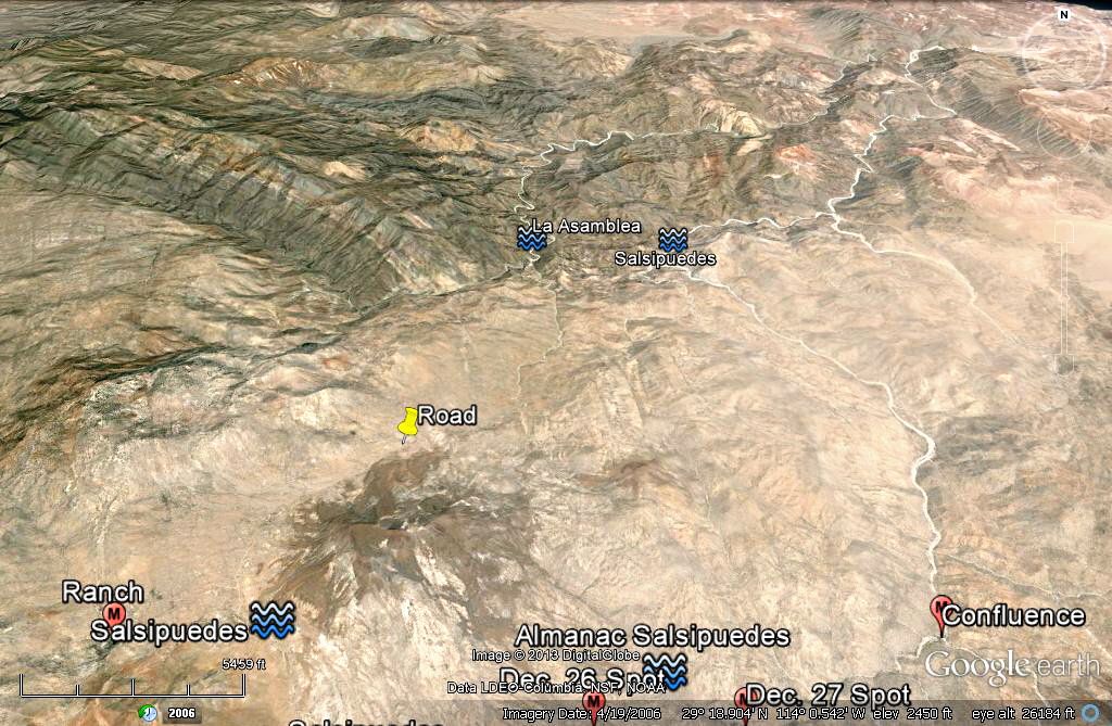
|
|
|
Santiago
Ultra Nomad
    
Posts: 3540
Registered: 8-27-2003
Member Is Offline
|
|
Rookie question: Why is Salsipuedes 'better' than La Asamblea?
|
|
|
Barry A.
Select Nomad
      
Posts: 10007
Registered: 11-30-2003
Location: Redding, Northern CA
Member Is Offline
Mood: optimistic
|
|
Excellent GE photos and depiction of sites, David. The mystery goes on, and you and other's make some excellent observations and learned-suppositions
which only tends to increase my curiosity about that area.
We need that Hillar helecoptor that ESG had at his disposal way back when, and a few ROKONS.
Barry
|
|
|
larryC
Super Nomad
   
Posts: 1499
Registered: 8-11-2008
Location: BoLA
Member Is Offline
|
|
A rokon would be an excellent bike to go up there on. You need something that you can throw into an aluminum boat and launch at Candeleros and motor
up to the La Asamblea rock beach and off load the bike there and head up the canyon. Or hire a panga in Bahia and have them drop you off and arrange
for a pick up a few days later. My quads are just too big and heavy for that scenario but a rokon or fat tire bike of any type would be great for
that. One of these days I'm going to go back up there and do some more exploring.
Larry
Off grid, 12-190 watt evergreen solar panels on solar trackers, 2-3648 stacked Outback inverters, 610ah LiFePo4 48v battery bank, FM 60 and MX60
Outback charge controllers, X-240 Outback transformer for 240v from inverters, 6500 watt Kubota diesel generator.
|
|
|
Mark_BC
Nomad
 
Posts: 137
Registered: 12-1-2013
Location: Vancouver, BC
Member Is Offline
|
|
OK so the plan now is to go check out the other entry point I was talking about from the east, from Laguna Seca. I'm going to take the rental car up
there tomorrow for a night or two and hike in. It's only about 5-8 km of hiking (one way) after 5 km of bike riding across the wash. What I want to
check out is if the terrain allows certain sections of difficult wash to be bypassed, i.e. is it like most of the washes you see down here with
reasonably sloped sidehills. It looks like it from GE. The difficulty with the upper canyon where I just went is that there is no bypass around
impasses when the canyon walls are vertical boulders!
It will involve a 200 m elevation gain and then back down the other side but that's pretty easy if the terrain isn't too rough. I'll do the Spot
checks like before. I'm a little worried about leaving the car exposed for a few days, what about looters? I'll try to hide it behind a hill
somewhere, and I'll stash 10 litres of water somewhere no one will find in case the car gets trashed and I have to ride out.
Then if I give it an "OK" I'll start thinking about the next attempt with bikes! Next time with other people.
|
|
|
| Pages:
1
..
5
6
7
8
9
..
25 |

