| Pages:
1
..
7
8
9
10
11
12 |
rts551
Elite Nomad
     
Posts: 6700
Registered: 9-5-2003
Member Is Offline
|
|
I would not take it right now in a Neon. Maybe by March they will have cleaned up the road some. Check back later.
Given the amount of equipment and people working they will complete more than 6-7 miles per year....Probably be finished at the end of 2016 if they
continue at the same pace. Budget problems or pulled off to work damaged roads and well.....who knows.
But they are working faster than at any other time I have seen in Baja/Baja Sur.
|
|
|
mtnpop
Senior Nomad
  
Posts: 597
Registered: 9-8-2009
Location: Colorado/mulege
Member Is Offline
|
|
traveled through today 12/9.... amazing what has been done since we came through in Oct... They have several mountains of rather large rock to move
looks like... the reroute is interesting... looks like it will slide south to hit Mex 1 south of the current intersection...
It is 50 times better traveling on it than it was even 3 years ago...
bridge work is moving along at a fast pace also...
now if they would patch the potholes on mex 1 south of Chapala..
here i am complaining at the little things..
still no Diesel at Gonzoga......
Common sense is a flower that doesn\'t grow in everyone\'s garden.....
A wise man once spoke nothing.....
Never kick a cow chip on a hot day!!
|
|
|
Whale-ista
Super Nomad
   
Posts: 2009
Registered: 2-18-2013
Location: San Diego
Member Is Offline
Mood: Sunny with chance of whales
|
|
Quote: Originally posted by US 41  | I'm considering driving to Cabo San Lucas from Indiana in either February or March (I hate flying so that is not an option). Will this paving project
be finished by then? This would be a really nice shortcut if I end up going. If it isn't finished by the time I go is the 20 mile gravel portion of
the road in fairly good condition? I drive a Dodge Neon which sits kind of low to the ground.
Also is Baja safe enough to drive in by yourself? The only place in Mexico I have ever been in is a small town called Boquillas which is across the
river from the Big Bend Nat'l Park (its very safe). I'd most likely enter/leave Mexico at the Lukeville, AZ POE if that matters. Thanks for any
responses. |
Welcome to the Nomad board US 41!
Can't speak re:this road, but it's slow going and likely won't be done that soon.
As far as safety- Baja in general is safe. Good if you speak even a little Spanish, for dealing with the stops for gas, food, hotels etc.
Other discussions on Nomad will go into detail re:various ways driving is different in Baja vs. US (MX1 is a single lane hwy, built for commerce not
speed; limited/no lighting; livestock wandering on road in open range areas...).
Plan on it being scenic, safe and taking it slow and you'll do fine. Have fun!
\"Probably the airplanes will bring week-enders from Los Angeles before long, and the beautiful poor bedraggled old town will bloom with a
Floridian ugliness.\" (John Steinbeck, 1940, discussing the future of La Paz, BCS, Mexico)
|
|
|
Hook
Elite Nomad
     
Posts: 9011
Registered: 3-13-2004
Location: Sonora
Member Is Offline
Mood: Inquisitive
|
|
Lukeville would be a strange place to cross (unless you know someone in Gila Bend, Ajo or Lukeville) or unless you want to take the stretch of road
from Puerto Penasco around to San Felipe through El Golfo de Santa Clara. So, you wouldnt HAVE to take the toll road to Mexicali.
But I dont think the road from PP to SF is THAT scenic, really. And there are long stretches with no services.
|
|
|
LaTijereta
Super Nomad
   
Posts: 1192
Registered: 8-27-2003
Location: Loreto
Member Is Offline
|
|
Came through this week.. From Loreto to San Felipe took 9 1/2 hours, including about 1 hour to run the graded section.. That section has about 10
miles mix of very smooth grade sections, with a fair amount of traffic going this way..
Took another 3 hours to run up to the border crossing at Tecate on the toll Hwy 2..
Overall.. saved about 85 miles and 1 1/2 hrs verses going down Hwy 1 via Tecate crossing.. 
Democracy is like two wolves and a lamb voting on what to have for lunch. Liberty is a well-armed lamb contesting the vote.
Ben Franklin (1759)
|
|
|
Hook
Elite Nomad
     
Posts: 9011
Registered: 3-13-2004
Location: Sonora
Member Is Offline
Mood: Inquisitive
|
|
Quote: Originally posted by LaTijereta  | Came through this week.. From Loreto to San Felipe took 9 1/2 hours, including about 1 hour to run the graded section.. That section has about 10
miles mix of very smooth grade sections, with a fair amount of traffic going this way..
Took another 3 hours to run up to the border crossing at Tecate on the toll Hwy 2..
Overall.. saved about 85 miles and 1 1/2 hrs verses going down Hwy 1 via Tecate crossing..  |
And a lot more scenic and a lot less traffic stress.
|
|
|
US 41
Junior Nomad

Posts: 43
Registered: 12-7-2015
Member Is Offline
|
|
Thanks for all the responses. I'm glad to hear that Baja is generally pretty safe. I think I will enter at Tecate and take Hwy 3 south to Hyw 1 in
Ensenada, rather than enter at Sonoyta since Hwy 5 isn't finished yet.
|
|
|
bajabuddha
Banned
Posts: 4024
Registered: 4-12-2013
Location: Baja New Mexico
Member Is Offline
Mood: Always cranky unless medicated
|
|
US 41,
am in Nueva Mexico, travelled the stretch for years. If i'm in a slo-mo mood, will cross at Sonoyta, but no longer any further east due to "no-man's
land'' rumors, and haven't heard anything different for a while.
Otherwise, for convenience and 'cruise-control' (in more ways than one) take the U.S. freeway to Tecate. If you're trailer trash camping like me,
Yuma has a new Wally World at exit 11-A, best RV park for miles; open 24/7, good for stocking up on stuff and late-night snacks. Park over by the
adjacent bank, you'll have company.
I do love the drive from Mexicali to Sonoyta SOB, plan on camping in Puerto Peñasco or Organ Pipe NM campground. DO NOT boondock off the highway.
If in PP, plan on a few extra days and check into a tour of El Pinacate Parque National, great volcanic 'stuff', but again, pay the bucks, take a
tour; no-man's land thanks to "The War On Drugs". The 'Taint' isn't Baja, but still worth seeing, eventually.
Happy trails.
I don't have a BUCKET LIST, but I do have a F***- IT LIST a mile long!
86 - 45*
|
|
|
advrider
Super Nomad
   
Posts: 1920
Registered: 10-2-2015
Member Is Offline
|
|
Question, I will be headed down this Thursday for a week of camping. Sf, Gonzaga bay and maybe BOLA for a few nights? Can you drive the new Highway
until the pavement ends and then does it continue on as dirt or just end? I was planning on cutting of and going out past Cocos to BOLA? Is this the
best way? I will be towing my off road tent trailer with a Nissan xterra so the dirt shouldn't be an issue.
|
|
|
David K
Honored Nomad
        
Posts: 65428
Registered: 8-30-2002
Location: San Diego County
Member Is Offline
Mood: Have Baja Fever
|
|
Quote: Originally posted by advrider  | | Question, I will be headed down this Thursday for a week of camping. Sf, Gonzaga bay and maybe BOLA for a few nights? Can you drive the new Highway
until the pavement ends and then does it continue on as dirt or just end? I was planning on cutting of and going out past Cocos to BOLA? Is this the
best way? I will be towing my off road tent trailer with a Nissan xterra so the dirt shouldn't be an issue. |
Yes, this is the Gulf Side Highway and no other route is open between Gonzaga and Coco's Corner. The pavement ends 12 miles from Gonzaga (Pemex) and
Coco's is 10 more dirt miles ahead. The new highway will swing west and miss Coco's when it is open, but you will still be able to drive to his place
as long as they don't put the stupid barb wire across the existing dirt roads, as they have done in many other places!
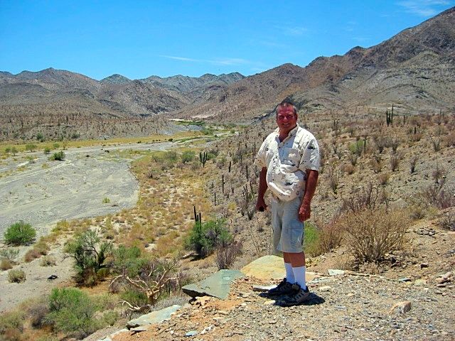
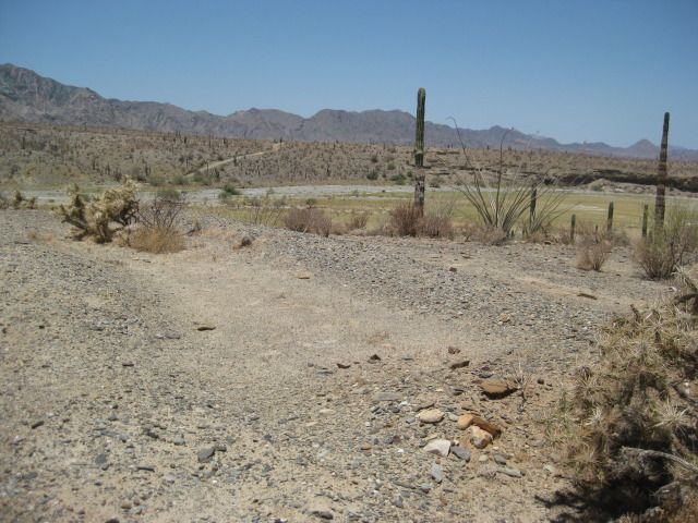
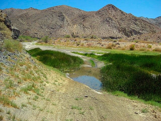
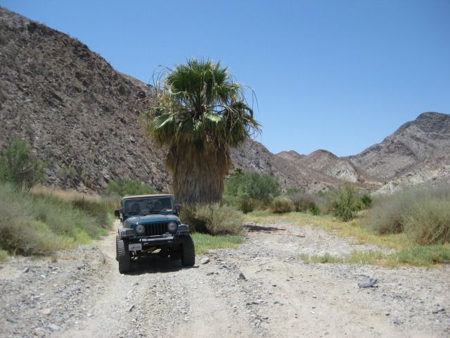
From Coco's Corner, you have an option instead of the construction road to Laguna Chapala: Turn east and go to Calamajué (the cove east or the canyon,
mission, river south from a junction 6.3 miles east from Coco's). The river/canyon road is a 4WD route, but was very easy and the water was not deep
on my last trip through in 2012. I have not heard it being worse since. That road reaches Hwy. 1 at El Crucero (km 261) or earlier (km 251) using the
1973 water truck road.

|
|
|
Gulliver
Senior Nomad
  
Posts: 651
Registered: 11-18-2013
Member Is Offline
|
|
You can drive the pavement South as far as it goes and it will lead you right into the dirt section over to Rt. 1. You just need to take it easy on
the dirt.
Yes, it is all chewed up but no, there isn't anything close to a clearance problem or any places where you are going to drop over a cliff. Just
boring, dusty and lots of pointy imbedded rocks that would love to raise hell with your tire sidewalls of you whack into them at speed.
I have been through there with everything from a motocross bike to a Honda Accord with bald tires. I towed an eight foot cargo trailer behind my old
class B last Spring and except for things flopping around back there due to my doltish packing, nothing happened. You gotta use your judgement and
take it easy.
|
|
|
advrider
Super Nomad
   
Posts: 1920
Registered: 10-2-2015
Member Is Offline
|
|
I have been up the wash on my bike a few times. What would be the faster/better way to get over to HWY 1? The new HWY/dirt or past Cocos? I was
thinking Cocos just so we could stop and say HI? Thanks for the information guys.
|
|
|
willardguy
Elite Nomad
     
Posts: 6451
Registered: 9-19-2009
Member Is Offline
|
|
" Just boring, dusty and lots of pointy imbedded rocks that would love to raise hell with your tire sidewalls of you whack into them at speed."
exactly! someone should pave that thing! 
|
|
|
Gulliver
Senior Nomad
  
Posts: 651
Registered: 11-18-2013
Member Is Offline
|
|
The new paved stuff doesn't bypass Coco's. You just follow your nose and the auto freight trucks. It's the same old route after you leave the
pavement.
Straight to Rt. 1 would take less time. Especially towing. The wash is cool but it's not my choice to make miles.
Unless it's raining, the old route is fine. When it rains the clay over near Rt. 1 gets slimy.
[Edited on 12-13-2015 by Gulliver]
|
|
|
chuckie
Elite Nomad
     
Posts: 6082
Registered: 2-20-2012
Location: Kansas Prairies
Member Is Offline
Mood: Weary
|
|
I heard that they were thinking about improving it? Does anyone have a current report?
|
|
|
Gulliver
Senior Nomad
  
Posts: 651
Registered: 11-18-2013
Member Is Offline
|
|
Read back on this thread. The short answer is yes. Not done and won't be for a while.
|
|
|
chuckie
Elite Nomad
     
Posts: 6082
Registered: 2-20-2012
Location: Kansas Prairies
Member Is Offline
Mood: Weary
|
|
How is the WIFI?
|
|
|
David K
Honored Nomad
        
Posts: 65428
Registered: 8-30-2002
Location: San Diego County
Member Is Offline
Mood: Have Baja Fever
|
|
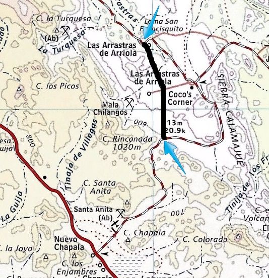
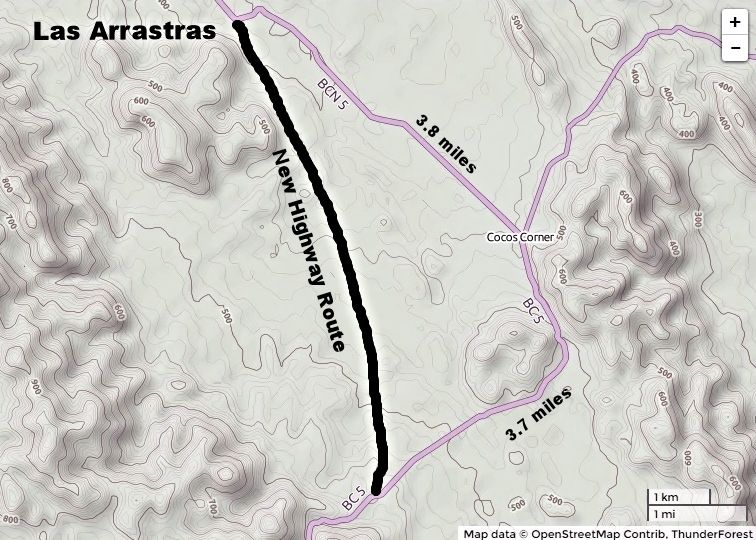
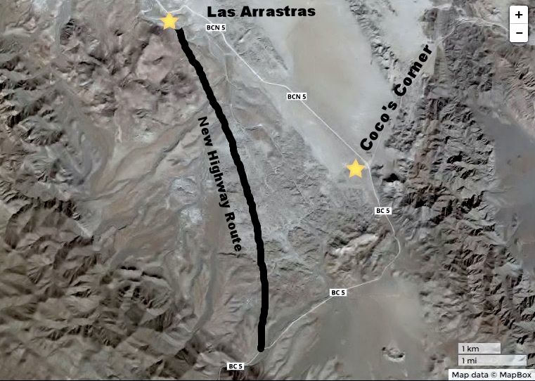
All traffic now goes to/ through Coco's Corner, but the new paved highway will bypass Coco's Corner when finished... it leaves the current route at
Las Arrastras de Arriola and runs 3 km west of Coco's Corner, rejoining the route as it enters the mountains. I made these maps when I last returned
from there...
|
|
|
advrider
Super Nomad
   
Posts: 1920
Registered: 10-2-2015
Member Is Offline
|
|
Nice work on the maps! Thanks for the info...
|
|
|
micah202
Super Nomad
   
Posts: 1615
Registered: 1-19-2011
Location: vancouver,BC
Member Is Offline
|
|
.
....wow,,I guess things will become extra-more quiet at Coco's
https://www.youtube.com/watch?v=1QGIdC6ARFY
.
|
|
|
| Pages:
1
..
7
8
9
10
11
12 |

