larryC
Super Nomad

Posts: 1499
Registered: 8-11-2008
Location: BoLA
Member Is Offline
|
|
The back way into the Santa Maria mission
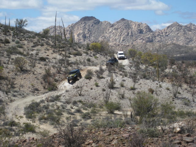
Anyone done this trail? I just did it this past Friday and it is doable but not for the faint of heart. I consider my off road skill level to be
somewhere between novice and intermediate but this road scared the crap out of me. I took that route because I didn't think I had the skill to make it
out the rocky uphill trail I came in on. My travel partner decided not to go down the trail and I was already down in there and couldn't turn around
so I continued on. The alternate route out is marked by a small rock pile about 1/4 mile before you get to the actual mission, and from there for the
first miile or so is hunt and peck to stay on the trail.
It is a beautiful ride with moments of shear terror. I was all alone so I was scared the whole time anyway about breaking down out there but luck was
with me. The trail hits Hwy1 about 10 kilometers south of Catavina. I saw the trail on GE and decided to try it but my plan was to have second vehicle
with me but that didn't work out. Oh well alls well that ends well. I was driving a Rzr xp4 1000.
Off grid, 12-190 watt evergreen solar panels on solar trackers, 2-3648 stacked Outback inverters, 610ah LiFePo4 48v battery bank, FM 60 and MX60
Outback charge controllers, X-240 Outback transformer for 240v from inverters, 6500 watt Kubota diesel generator.
|
|
|
David K
Honored Nomad
Posts: 65561
Registered: 8-30-2002
Location: San Diego County
Member Is Offline
Mood: Have Baja Fever
|
|
I was curious about this new road, which is easy to follow on Google Earth. I presume you are speaking of the San Ignacito to Santa María road, that
had been shown as a foot trail on maps for years but now looks like an auto road...?
|
|
|
larryC
Super Nomad
Posts: 1499
Registered: 8-11-2008
Location: BoLA
Member Is Offline
|
|
Yes that's it. Someone moved a lot of rocks and widened it to allow a SxS to get through. I also saw lots of motorcycle tracks. Thank goodnes they
were there I used them alot to find where the trail went. Really a fun ride.
Off grid, 12-190 watt evergreen solar panels on solar trackers, 2-3648 stacked Outback inverters, 610ah LiFePo4 48v battery bank, FM 60 and MX60
Outback charge controllers, X-240 Outback transformer for 240v from inverters, 6500 watt Kubota diesel generator.
|
|
|
David K
Honored Nomad
Posts: 65561
Registered: 8-30-2002
Location: San Diego County
Member Is Offline
Mood: Have Baja Fever
|
|
Quote: Originally posted by larryC  | | Yes that's it. Someone moved a lot of rocks and widened it to allow a SxS to get through. I also saw lots of motorcycle tracks. Thank goodnes they
were there I used them alot to find where the trail went. Really a fun ride. |
On Google Earth, it looks like a road for autos. It can't be worse than the last four miles to the mission on the Santa Ynez road, can it? I am
wondering if it is passable in my Tacoma as an 'easier to drive route' than the original road from Santa Ynez.
In 2022:


|
|
|
larryC
Super Nomad
Posts: 1499
Registered: 8-11-2008
Location: BoLA
Member Is Offline
|
|
I would never tell someone that they can or can't get through some where but there were a couple of places where my Rzr just cleared by a couple of
inches getting between two large boulders. If you want to go sometime let me know I'll tag along and watch. It would be an adventure. I would say that
it is easier route up and out of the mission than going back through Rancho Santa Inez. I was scared because I was alone and to get stuck or break
down out there would have probably meant a long and slow death.
Off grid, 12-190 watt evergreen solar panels on solar trackers, 2-3648 stacked Outback inverters, 610ah LiFePo4 48v battery bank, FM 60 and MX60
Outback charge controllers, X-240 Outback transformer for 240v from inverters, 6500 watt Kubota diesel generator.
|
|
|
mtgoat666
Platinum Nomad
Posts: 21083
Registered: 9-16-2006
Location: San Diego
Member Is Offline
Mood: Hot n spicy
|
|
| Quote: Originally posted by larryC | | I was scared because I was alone and to get stuck or break down out there would have probably meant a long and slow death. |
No need to die due to vehicle break down. Always take along extra water in the desert (and other survival essentials), and always be prepared to walk
out if necessary.
Woke!
Hands off!
“Por el bien de todos, primero los pobres.”
“...ask not what your country can do for you – ask what you can do for your country.” “My fellow citizens of the world: ask not what America
will do for you, but what together we can do for the freedom of man.”
Pronoun: the royal we
|
|
|
David K
Honored Nomad
Posts: 65561
Registered: 8-30-2002
Location: San Diego County
Member Is Offline
Mood: Have Baja Fever
|
|
Thanks Larry. My Baja traveling days may be few and far between but I would like to check this road out as an example on how locals make roads through
such harsh terrain. There had been a foot trail in roughly the same place. Maps call it Puerto La Misión!
Baja Nomad Norm, aka 'rockman' wrote about backpacking to the mission this way and continuing on to Punta Final on the coast.
From 1993:
BACKPACKING
Mision Santa Maria
By Norm Christie
--------------------------------------------------------------------------------
The ruins of Mision Santa Maria de Los Angeles are about as far from a road as any mission on the Baja California peninsula. I had tried for two years
to mobilize some friends for a backpacking trip into the site without success. So, in mid-September 1993, when "Dr. Bob" Binton phoned me to say that
he had three friends wanting to make the hike in October, I enthusiastically accepted his invitation. We rendezvoused near Catavina on the eighteenth
of October. During the next five days we experienced some of the most fascinating and beautiful areas on the peninsula.
The Santa Maria mission was the last mission built by the Jesuits before they were expelled from Mexico for political intrigues. The area, which
includes freshwater springs in a valley named "Cabujacaamang" by the Indians, was first seen by Father Fernando Consag in 1746, when he discovered
Bahia San Luis Gonzaga on the Sea of Cortez. The mission itself was built in 1767 by Father Arnes and Diez as the third in a string of remote
missions. It was designed to replace Mision Calamajue which was built in the previous year, but was found to have water that was too highly
mineralized to sustain crops.
Although built in a wide canyon surrounded by volcanic rock and granite, Mision Santa Maria was the only mission built by the Jesuits mainly of adobe
bricks rather than stone. After the Jesuits reluctantly departed from Baja Sur, the Franciscans occupied the site for a few months in 1768, but
abandoned it as a principle mission when they began construction of the new Mission San Fernando de Velicata, forty miles to the northwest, in 1769.
At that time, the Santa Maria mission became an outpost of Mission San Francisco Borja until 1818 when it was permanently abandoned.
Beginning in 1961, attempts were made to bulldoze a trail from Rancho Santa Ines, past the Santa Maria mission to Bahia Gonzaga on the Sea of Cortez.
Constructed with great amounts of effort, the road reached a point about a half mile east of the mission on the Camino Real, but was abandoned because
of impassable terrain. Today that trail has eroded and is obliterated in many areas, but is still the most common route for Santa Maria's infrequent
visitors.
Our group decided on a different route. Our starting point was the small "Chelanga" gold mine just north of Jaraguay, reached by a dirt road turning
off the highway at km 187. Our route was northward, crossing the peninsula divide at Puerto la Mission (elevation 2500). We passed grinding stones,
sleep circles and other evidence of early Indians. The rock in this are is mainly volcanic. As we proceeded northward, we dropped down into a dry wash
which had eroded into the light colored granite under the volcanics. We encountered our first waterholes about one mile past the divide. Many maps
identify this canyon as Canon Santa Maria, but in fact, this canyon runs into the real Canon Santa Maria (as identified by the locals and historians)
about a mile below the mission. We continued northeast in this canyon. Occasional pools of water developed into a continuous small stream which
occasionally blossomed into large pools surrounded by forests of palm trees. This water is present throughout the entire year. I used a filter before
drinking the water, but "Tomas" Campbell, a fellow hiker, took his chances and drank the the water straight from the stream during the entire trip
without ill effects. A few wild mountain sheep, deer and smaller wild animals inhabit this area, but free-range cattle very rarely get up into this
remote yet enticing region.
There are two main types of palm tree here; Palma Verde (Palma Almenico) and Palma Azul (Palma Senico and Palma Taco). Both bear small edible fruits
which taste, as one might imagine, like dates. They add a gourmet touch when pitted and added to instant Quaker Oats in the mornings.
Our first night's campsite was in the canyon northwest of Pico Colorado at an elevation of about 1600 feet. The next morning, Wednesday, we explored
some tributary canyons in the area and then departed the campsite at 11:30 AM. Hiking over the smoothly eroded granite boulders in the steep sided
canyon, we arrived at the junction of this canyon and the main Santa Maria canyon at 2:15 PM. We had been told that the best campsite in the area was
about 1/4 mile downstream in an oasis-like setting with a large pool. The Santa Maria mission is about one mile upstream from the junction.
The following morning, leaving our sleeping bags and camp gear at the oasis, we hiked up the broad main canyon (the real Canon Santa Maria), to the
mission. I had read that the mission had been built of stone blocks and adobe, but there was no evidence of stone blocks anywhere. The site originally
consisted of a large adove church building, and adobe barracks-like quarters and storage building, and a stone corral. Aerial photos show evidence of
other buildings that were probably made of palm wood, but it is not evident on the ground. A photo published in 1908 shows the church walls to be much
higher than they are now, and the storage/barracks building to be nearly intact (though roofless). Today, a few pits are evident where treasure
hunters may or may not have found the legendary lost treasure of the Jesuits. A small trickle of running water nourishes a glassy palm forest along
the watercourse, but there are no deep pools remaining near the mission. Remnants of a crude aqueduct may still be seen.
The mission had attracted more than 300 Indians when the cadre of newly arrived Franciscans moved north ward in 1768. Although there was sufficient
water here, there was insufficient arable soil to grow the corp needed to keep the Indians attracted to the church.
The following morning, we split up and explored various tributary canyons. We were mainly searching for rock art and pictographs which had been
reported in the area. No significant art was found that day, but some garnet crystals were discovered in quartz veins in Cerro Pinto canyon, south of
the main canyon. This canyon has running water (sometimes underground) and several large, deep water holes.
On the morning of October 20, we cleaned our campsite and packed up for the last leg of our hike toward Bahia Gonzaga. Our local guide, Prieto, told
us that the main canyon downstream had several impassable areas of deep pools flanked by vertical smooth awls of granite, so we hiked up above the
canyon, on its north rim, along the remnant of the old Camino Real. This involved climbing slightly to a maximum elevation of 1375 feet (the west end
of the bulldozed trail) and proceeding for about a half mile. Along this stretch we observed several rocks with petroglyphs. We then returned to the
floor of the canyon (675 feet) where there was still water. As we proceeded westward, the canyon became wilder and sandier. Reaching the beginning of
the large alluvial fan at about 575 feet elevation, there was no sign of surface water; it was now flowing under the sand. We walked about another
mile before arriving at our previously arranged meeting site with a couple of vehicles (with ice chests full of notably cool refreshments) and
proceeded on wheels to Punta Final where resident friends were preparing a welcome back dinner.
We were all tired, but not exhausted. Although we did not have a thermometer, temperatures were estimated to range from about 85F during the day to
55F at night. I had made the mistake of wearing light weight hiking boots. They began to fall apart while we crossed the sharp stones of the volcanic
terrain on the first day. Temporary repairs were made with an awl and some cord, but I suggest that future hikers in this area wear stronger boots. On
our final evening, the boots, our only casualty, were cremated and given a decent burial.
Getting there: The turnoff to our trailhead at the Chelanga mine is 6.5 miles south of Catavina on Highway 1. Catavina is 295 miles south of Tijuana,
and the location of a nice La Pinto hotel, gas station (with mechanics) and a great little cafe at the station. More elegant meals (and margaritas)
are available at the hotel. An alternate trailhead or exit point is Rancho Santa Inex, on a signed, paved side road 1/2 mile south of Catavina. Here
there is a Flying Samaritans medical clinic, paved runway, and a cafe where you can get cool drinks and information. The terminal point for our hike
is near the coastal gravel road from Puertocitos to Highway 1 at Laguna Chapala. This road is good from Alfonsina's southward, but terrible between
Puertocitos and Alfonsina's. Ice, drinking water and a good dirt airstrip are available at the turnoff to Alfonsina's. On this route, the last
dependable gas and supplies are at San Felipe, 155 miles south of Mexicali.
Climate: Because summer temperatures often exceed 100 degrees, this trip would be very uncomfortable from July through September. December through
March can be cold, sometimes in the 40's at night. Rain is rare, but drizzle is possible in the winter, and tropical downpours occur occsionally in
summer.
Recommended Supplies and Equipment: In addition to common backpacking equipment, the following items should be emphasized. Sturdy boots, topo map and
altimeter, water purifier, star chart (incredibly clear sky), sun screen, sunglasses, tweezers and antiseptic (for cactus pines), Mexican insurance
for your vehicle.
Dangers and Annoyances: If rain is observed or seems likely, do not camp in the canyon bottoms; flash floods can be killer in this region. Although we
saw none on our trip, rattlesnakes and scorpions do exist in all parts of Baja. These creatures are mainly nocturnal, so watch where you put your
hands and feet at night. We experienced no insect pests, but flies and gnats can be abundant after rain. Although the Mexican government tries to keep
the roads in good order, Highway 1 is about one foot per lane narrower than US. roads, has heavy bus and truck traffic, has no shoulders and drivers
may suddenly come up on potholes and cattle. Driving at night is not recommended, especially for newcomers to Baja.
|
|
|
David K
Honored Nomad
Posts: 65561
Registered: 8-30-2002
Location: San Diego County
Member Is Offline
Mood: Have Baja Fever
|
|
A year and a half ago, Harald shared the new road location with us, including a sat map with it clearly shown in white overlay:
https://forums.bajanomad.com/viewthread.php?tid=98221

|
|
|
larryC
Super Nomad
Posts: 1499
Registered: 8-11-2008
Location: BoLA
Member Is Offline
|
|
| Quote: Originally posted by mtgoat666 | | Quote: Originally posted by larryC | | I was scared because I was alone and to get stuck or break down out there would have probably meant a long and slow death. |
No need to die due to vehicle break down. Always take along extra water in the desert (and other survival essentials), and always be prepared to walk
out if necessary. |
Wow, who would have thought to take extra water? Yeah I had extra water and food but the temperatures out there were 104 and not too much shade out
away from the rzr. What I am seriously looking into is a Starlink for the vehihcle or get the new service DtC (direct to cell) that Starlink is coming
out with hopefully this year. That will take alot of the worry out of the exploring.
Off grid, 12-190 watt evergreen solar panels on solar trackers, 2-3648 stacked Outback inverters, 610ah LiFePo4 48v battery bank, FM 60 and MX60
Outback charge controllers, X-240 Outback transformer for 240v from inverters, 6500 watt Kubota diesel generator.
|
|
|
PaulW
Ultra Nomad
Posts: 3113
Registered: 5-21-2013
Member Is Offline
|
|
Many of us use inReach for communications as a cost effective way to go.
Starlink in the boondocks requires a 12v Dc setup to replace the 110 v that it comes with. That means a big battery and a new 12v router and an
correct way to charge the new 12v battery. Yes guys do it all the time usually on a big truck or overlanded camping rig.
|
|
|
larryC
Super Nomad
Posts: 1499
Registered: 8-11-2008
Location: BoLA
Member Is Offline
|
|
Its not available yet but maybe by the end of the year Starlink through T-Mobile will offer a "direct to cell" service througfh your smart unmodified
cell phone. So no batteries, starlink dishes, inverters, routers or anything else required. Just your personal cell phone. It will communicate
directly with the starlink satellites in low earth orbit. Just open the google maps app and use the satellite view and you will have a google earth
type navigation service in your vehicle. I'm going to sign up for it when it is available.
For more info just google it.
https://www.cnet.com/tech/spacex-and-t-mobiles-starlink-base...
[Edited on 5-24-2024 by larryC]
Off grid, 12-190 watt evergreen solar panels on solar trackers, 2-3648 stacked Outback inverters, 610ah LiFePo4 48v battery bank, FM 60 and MX60
Outback charge controllers, X-240 Outback transformer for 240v from inverters, 6500 watt Kubota diesel generator.
|
|
|
PaulW
Ultra Nomad
Posts: 3113
Registered: 5-21-2013
Member Is Offline
|
|
Did you get the impression that a bunch of new satellite's will be requires or will they use existing ones?
|
|
|
larryC
Super Nomad
Posts: 1499
Registered: 8-11-2008
Location: BoLA
Member Is Offline
|
|
I think they are putting up more of the newer larger sats that have the built in cell phone compatability. I guess the same as an orbiting cell tower.
I hope they don't make it so expensive that it is cost prohibitive.
There is a guy on youtube, JCristina that produces lots of starlink videos and he talks about it alot.
https://www.youtube.com/watch?v=_LgCmFEJaXs
[Edited on 5-25-2024 by larryC]
[Edited on 5-25-2024 by larryC]
Off grid, 12-190 watt evergreen solar panels on solar trackers, 2-3648 stacked Outback inverters, 610ah LiFePo4 48v battery bank, FM 60 and MX60
Outback charge controllers, X-240 Outback transformer for 240v from inverters, 6500 watt Kubota diesel generator.
|
|
|
Ken Cooke
Elite Nomad
Posts: 8971
Registered: 2-9-2004
Location: Riverside, CA
Member Is Offline
Mood: Pole Line Road postponed due to injury
|
|
| Quote: Originally posted by mtgoat666 | | Quote: Originally posted by larryC | | I was scared because I was alone and to get stuck or break down out there would have probably meant a long and slow death. |
No need to die due to vehicle break down. Always take along extra water in the desert (and other survival essentials), and always be prepared to walk
out if necessary. |
Walking out is entirely possible. A Hemet firefighter walked and jogged beside our Jeeps 2 decades ago from the swamp to the hill overlooking Rancho
Santa Ines. Fun memories.
|
|
|
AKgringo
Elite Nomad
Posts: 6352
Registered: 9-20-2014
Location: Anchorage, AK (no mas!)
Member Is Offline
Mood: Retireded
|
|
| Quote: Originally posted by Ken Cooke |
Walking out is entirely possible. A Hemet firefighter walked and jogged beside our Jeeps 2 decades ago from the swamp to the hill overlooking Rancho
Santa Ines. Fun memories. |
Two decades ago I would have agreed with you. Long term abuse of my knees has finally caught up with me, and at age 78 the walk better not be too
long!
By the way Ken, it is good to see you posting here! Since I first started following this forum in 2014, you are one of the Nomads I have hoped to
meet up with some day.
[Edited on 6-3-2025 by AKgringo]
If you are not living on the edge, you are taking up too much space!
"Could do better if he tried!" Report card comments from most of my grade school teachers. Sadly, still true!
|
|
|
advrider
Super Nomad
Posts: 1924
Registered: 10-2-2015
Member Is Offline
|
|
Rode in and out on my 500 about four years ago, the widow maker is properly named. Probably wouldn't ride it today, but the RZR would be fun. How was
the new road going out?
|
|
|
David K
Honored Nomad
Posts: 65561
Registered: 8-30-2002
Location: San Diego County
Member Is Offline
Mood: Have Baja Fever
|
|
That new track to the mission from San Ignacito was recently traveled by Nomad 'Emerson' of Mexicali and others of their Toyota Land Cruiser club.
They sustained body damage because the trail was made for motorcycle and side by side riders, not full-size 4×4s.
|
|
|
Ken Cooke
Elite Nomad
Posts: 8971
Registered: 2-9-2004
Location: Riverside, CA
Member Is Offline
Mood: Pole Line Road postponed due to injury
|
|
Text | Quote: Originally posted by AKgringo | | Quote: Originally posted by Ken Cooke |
Walking out is entirely possible. A Hemet firefighter walked and jogged beside our Jeeps 2 decades ago from the swamp to the hill overlooking Rancho
Santa Ines. Fun memories. |
Two decades ago I would have agreed with you. Long term abuse of my knees has finally caught up with me, and at age 78 the walk better not be too
long!
By the way Ken, it is good to see you posting here! Since I first started following this forum in 2014, you are one of the Nomads I have hoped to
meet up with some day.
[Edited on 6-3-2025 by AKgringo] |
Full disclosure, the (late 20-something/early 30-something) 🚒 Firefighter jogged and walked beside our Jeeps on a late November afternoon when the
temperatures were comfortable enough to do that. With bad knees, the rocky surface wouldn't be a very good idea. Thanks AKGringo!
|
|
|
PaulW
Ultra Nomad
Posts: 3113
Registered: 5-21-2013
Member Is Offline
|
|
Got a map?
| Quote: Originally posted by David K | | That new track to the mission from San Ignacito was recently traveled by Nomad 'Emerson' of Mexicali and others of their Toyota Land Cruiser club.
They sustained body damage because the trail was made for motorcycle and side by side riders, not full-size 4×4s. |
|
|
|
David K
Honored Nomad
Posts: 65561
Registered: 8-30-2002
Location: San Diego County
Member Is Offline
Mood: Have Baja Fever
|
|
| Quote: Originally posted by PaulW | Got a map?
| Quote: Originally posted by David K | | That new track to the mission from San Ignacito was recently traveled by Nomad 'Emerson' of Mexicali and others of their Toyota Land Cruiser club.
They sustained body damage because the trail was made for motorcycle and side by side riders, not full-size 4×4s. |
|
It is actually on most modern maps, including the Benchmark Atlas (as a very thin line) and easy to follow on Google Earth.
Although probably an error, the foot trail it enhanced to a sxs road is shown as a road on the 2004 tourist map: 2004 Map
[Edited on 6-4-2025 by David K]
|
|
|
|


