| Pages:
1
2
3 |
Fatboy
Senior Nomad

Posts: 801
Registered: 6-28-2005
Member Is Offline
|
|
David,
Here is my path through La Rabia, the flags (g105 ect) are Kevin & Genevieve while my path is the blue line and as you can see they are quite
different though a section of it.
Then you compare that with what Crosby wrote..... "After 2 hours...indicated a sudden left turn up a side canyon. ....soon climbing a long cuesta of
decomposed granite. ....three hours from the Romero Ranch (Tres Palmas) we had gained over a thousand feet....)
So that put in the neighborhood of La Rabia. It is around 4 miles(probably closer to 4.5 miles) from Tres Palmas to the junction of La Rabia. So that
is really close to the '2 hours' and the 'sudden left turn' Crosby talks about.
Also, the upper half of my 'loop' away from the wash, you climb, quite sharply, up a hill of decomposed granite!
Now there surely could could be another 'side canyon' past La Rabia and it could take you up a hill of decomposing granite, but nothing really fits.
The point where I regain the the bed of La Rabia is about 850 above Tres Palmas, so that fits also.
Now I will say that the odd thing is when you go the La Rabia route you have to DROP DOWN to San Sebastion by 350 feet or so. I would tend to believe
that Crosby what have also mentioned that, so who knows?????

|
|
|
Fatboy
Senior Nomad
Posts: 801
Registered: 6-28-2005
Member Is Offline
|
|
Quote: Originally posted by bajaric  | Great report, describing second half of the hike north from San Sebastion,
..... remember where the trail was.
The El Camino Real web site has some detailed "waypoints" or "breadcrumbs" all along the route, I would think some techie person could load the
satellite view of Google earth on to some sort of electronic device with the trail and waypoints shown on it. |
Thanks.
To the waypoints, I do have them and they are very helpful. Problem is that at times you must turn right or left to get to a waypoint that is straight
ahead.
Which is the right way? What google earth shows from hundreds, if not thousands of feet in the air, does not always match what you are staring at on
the ground.
To the direction of travel and which way is easier.... I would say "going down" is much easier for route finding. So on this section going southwards
is much easier.
At least that is my belief....
Not because you can see, but because the washes are JOINING and not Y'ing, so there are way fewer left/right decisions that need to be made.
|
|
|
David K
Honored Nomad
Posts: 65243
Registered: 8-30-2002
Location: San Diego County
Member Is Offline
Mood: Have Baja Fever
|
|
Good morning John/ Fatboy.
I must say reading your posts brings the excitement of exploration back to Nomad's Trip Reports forum... Thank you!
The 3-D map blue line is super... Can you show the rest of your hike that way (I love maps, lol)?
Do you have any plans to hike other parts of El Camino Real... that are not as 'impossible' to find?
|
|
|
PaulW
Ultra Nomad
Posts: 3113
Registered: 5-21-2013
Member Is Offline
|
|
It is my belief that when making a track or just locating a prominent place using Google earth is very accurate and duplicable in the field using my
GPSs.
In the field using a hand held GPS to find that place you created from Google earth requires some movement of the handheld GPS. Then it gives you the
correct reading.
Creating a Wp using a handheld GPS is not as accurate. It depends on how many satellites are in view and how many channels the GPS has, and if the
user allows enough time to allow the satellite to lock. The result is much better when Wp or breadcrumb is part of a track.
|
|
|
David K
Honored Nomad
Posts: 65243
Registered: 8-30-2002
Location: San Diego County
Member Is Offline
Mood: Have Baja Fever
|
|
| Quote: Originally posted by PaulW | It is my belief that when making a track or just locating a prominent place using Google earth is very accurate and duplicable in the field using my
GPSs.
In the field using a hand held GPS to find that place you created from Google earth requires some movement of the handheld GPS. Then it gives you the
correct reading.
Creating a Wp using a handheld GPS is not as accurate. It depends on how many satellites are in view and how many channels the GPS has, and if the
user allows enough time to allow the satellite to lock. The result is much better when Wp or breadcrumb is part of a track. |
Indeed! Also, and Kevin mentions this on his website (CaminoRealBaja.com): The waypoint and other note placements on his Google Earth map do not
always match the true location... something shifts some of them after they are correctly placed.
|
|
|
cupcake
Nomad
Posts: 380
Registered: 4-23-2024
Member Is Offline
|
|
| Quote: Originally posted by bajaric | Great report, describing second half of the hike north from San Sebastion, then returning south to the rancho where the car was parked.
|
My understanding is that the car was parked at (or near) the Rancho San Sabastian, and that the direction of hiking was south through the San
Sabastian wash towards Tres Palmas. The return to the car was then northward. This is what I see on the topo map that David posted previously (the
first map in this thread). While compass direction is not marked on the portion of this posted map, it can be determined by David's statement that it
is the section south of San Borja and north of El Arco. Please correct me, anyone, if I am misreading this.
[Edited on 10-3-2024 by cupcake]
|
|
|
cupcake
Nomad
Posts: 380
Registered: 4-23-2024
Member Is Offline
|
|
| Quote: Originally posted by Fatboy | | Quote: Originally posted by cupcake | | Quote: Originally posted by Fatboy |
.......
I've added a small bear horn to my hiking kit, as I had two close bear sightings recently. The horn should also work well for dogs, coyotes, lions,
etc. The horn I have weighs next to nothing and is relatively inexpensive.
Bear Horn Video:
https://www.youtube.com/watch?v=07xYYn64uXU
[Edited on 10-2-2024 by cupcake] |
Roughly, what part of the country you in? Bears are interesting, in Grizzly country I carry bear spray but here in Northern California I rarely carry
anything for bears.
I do have a winter hike planned in February of 2025 here in Plumas County that I will most certainly be carrying bear spray on.
One reason is, of course, there are lots of Bears around here, but now there are also wolves.
Second reason is because of an odd set of circumstances I will start hiking around midnight and hike until the next morning on the first day.
|
My recent close bear sightings were very near the Mankar Flats campgound, which is at about the 6,500 foot level on the south escarpment of Mt. Baldy
(Mt. San Antonio), in the San Gabriel range of southern California.
My first sighting was at around 8am when a bear walked across the ground that my tent had been on just 5 minutes prior. A daytime sighting of a bear
which obviously had no, or little, fear of humans. My second sighting was days later, not too far from the first sighting, and it might have been the
same bear. This was also daytime and the bear was walking around a cabin.
I've been hiking in this area for decades, with many hundreds of ascents of the local mountains, and this is the best bear sighting I have had (a fact
which surprises my friends, who have had a number of bear encounters). I never carried bear deterent in this area before, but will from now on.
The fires of this past summer have destroyed a good portion of the food source these bears relied on, which might see them migrating to the unburned
areas (such as the Mankar Flats area described above).
[Edited on 10-3-2024 by cupcake] |
|
|
|
Fatboy
Senior Nomad
Posts: 801
Registered: 6-28-2005
Member Is Offline
|
|
| Quote: Originally posted by cupcake | | Quote: Originally posted by bajaric | Great report, describing second half of the hike north from San Sebastion, then returning south to the rancho where the car was parked.
|
My understanding is that the car was parked at (or near) the Rancho San Sabastian, and that the direction of hiking was south through the San
Sabastian wash towards Tres Palmas. The return to the car was then northward. This is what I see on the topo map that David posted previously (the
first map in this thread). While compass direction is not marked on the portion of this posted map, it can be determined by David's statement that it
is the section south of San Borja and north of El Arco. Please correct me, anyone, if I am misreading this.
[Edited on 10-3-2024 by cupcake] |
No, the car was parked at Los Corralles, which is not on most of the maps.
From there I hiked north to Tres Palmas, then on to San Sebastian, then further north another 7 or 8 miles.
Then I hiked back south to the car.
The ranchos go Rancho Nuevo, in the south and as you go northwards you pass Rancho Los Corralles, and they are both operating ranches. Then further
north is Tres Palmas, then even further north is San Sebastian which are just place names for the most part.
|
|
|
David K
Honored Nomad
Posts: 65243
Registered: 8-30-2002
Location: San Diego County
Member Is Offline
Mood: Have Baja Fever
|
|
| Quote: Originally posted by cupcake | | Quote: Originally posted by bajaric | Great report, describing second half of the hike north from San Sebastion, then returning south to the rancho where the car was parked.
|
My understanding is that the car was parked at (or near) the Rancho San Sabastian, and that the direction of hiking was south through the San
Sabastian wash towards Tres Palmas. The return to the car was then northward. This is what I see on the topo map that David posted previously (the
first map in this thread). While compass direction is not marked on the portion of this posted map, it can be determined by David's statement that it
is the section south of San Borja and north of El Arco. Please correct me, anyone, if I am misreading this.
[Edited on 10-3-2024 by cupcake] |
Unless specified, maps I post are oriented north, on top.
I see Fatboy cleared up the question of his car and hike direction.
San Sebastian was once a major ranch and appeared on many old maps but is abandoned and nearly vanished today. It is off the original El Camino Real,
to the east and downhill from the top of La Rabia canyon where three or more trails converge.
[I hope I got this right, eh Fatboy?]
Los Corrales is shown on the Benchmark Atlas (along with the 'ECR' trail). San Sebastian is not shown but its arroyo is named. It was located near
where the trail that splits at San Nicolas comes back together again. The left trail branch is La Rabia. Another La Rabia is on the map, near the
bottom. Tres Palmas is located just past the 'ECR' on the map on the right fork a short distance:
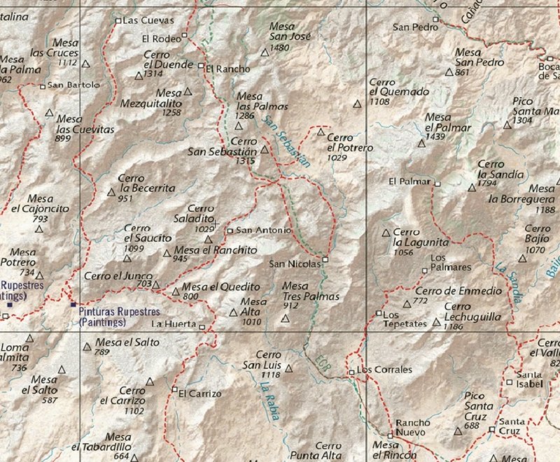
[Edited on 10-3-2024 by David K]
|
|
|
cupcake
Nomad
Posts: 380
Registered: 4-23-2024
Member Is Offline
|
|
| Quote: Originally posted by Fatboy | | Quote: Originally posted by cupcake | | Quote: Originally posted by bajaric | Great report, describing second half of the hike north from San Sebastion, then returning south to the rancho where the car was parked.
|
My understanding is that the car was parked at (or near) the Rancho San Sabastian, and that the direction of hiking was south through the San
Sabastian wash towards Tres Palmas. The return to the car was then northward. This is what I see on the topo map that David posted previously (the
first map in this thread). While compass direction is not marked on the portion of this posted map, it can be determined by David's statement that it
is the section south of San Borja and north of El Arco. Please correct me, anyone, if I am misreading this.
[Edited on 10-3-2024 by cupcake] |
No, the car was parked at Los Corralles, which is not on most of the maps.
From there I hiked north to Tres Palmas, then on to San Sebastian, then further north another 7 or 8 miles.
Then I hiked back south to the car.
The ranchos go Rancho Nuevo, in the south and as you go northwards you pass Rancho Los Corralles, and they are both operating ranches. Then further
north is Tres Palmas, then even further north is San Sebastian which are just place names for the most part. |
OK, thanks for setting me straight on this. What Kevin said regarding easier route finding when traveling north to south in this section makes more
sense to me now, as that would be traveling from higher to lower elevation, in general.
[Edited on 10-3-2024 by cupcake]
|
|
|
cupcake
Nomad
Posts: 380
Registered: 4-23-2024
Member Is Offline
|
|
| Quote: Originally posted by David K |
Unless specified, maps I post are oriented north, on top.
I see Fatboy cleared up the question of his car and hike direction.
San Sebastian was once a major ranch and appeared on many old maps but is abandoned and nearly vanished today. It is off the original El Camino Real,
to the east and downhill from the top of La Rabia canyon where three or more trails converge.
[I hope I got this right, eh Fatboy?]
Los Corrales is shown on the Benchmark Atlas (along with the 'ECR' trail). San Sebastian is not shown but its arroyo is named. It was located near
where the trail that splits at San Nicolas comes back together again. The left trail branch is La Rabia. Another La Rabia is on the map, near the
bottom. Tres Palmas is located just past the 'ECR' on the map on the right fork a short distance:
[Edited on 10-3-2024 by David K] |
This Benchmark Atlas map is nice in that it shows the ECR trail. It looks like it shows the ECR using the La Rabia drainage (this la rabia not marked
on the map), even though in reading this thread it looks like the San Sebastian drainage might be less difficult (probably because La Rabia has water
and this section of San Sebastian does not). Since la rabia means 'rage', like the disease, I wonder if all the la rabias will indicate tough going.
David, if there is a link to these good detailed topo and elevation maps you are posting in this thread, could you please pass along the url links? I
have been unable to find them online.
I wanted to mention something I read on Kevin and Genevieve's website that concerns me, and that is the reportedly increasing use of ECR water sources
by drug people for growing. Their website expresses the concern that in the future every water source on the ECR will be used by these people.
[Edited on 10-3-2024 by cupcake]
|
|
|
David K
Honored Nomad
Posts: 65243
Registered: 8-30-2002
Location: San Diego County
Member Is Offline
Mood: Have Baja Fever
|
|
Hi cupcake (reminds me of Guardians of the Galaxy),
All the Baja maps I have available to everyone (most you can zoom in for real close looks) are on my website (VivaBaja.com) on this page: https://vivabaja.com/maps/

|
|
|
cupcake
Nomad
Posts: 380
Registered: 4-23-2024
Member Is Offline
|
|
Thanks David. Strange how we give ourselves these names. I was eating a cupcake when I registered on Bajanomad, and simultaneously experiencing a
moment of low creativity. So, cupcake I am.
Thanks to your previous post on this thread, I can now address Fatboy as John, denoting the respect I feel for him.
I have started exploring the maps on your website; there is a lot to digest there. Managed to see some good topographical offerings, but have yet to
figure out how to download a PDF of them. Could be a limitation of the public computer I am using.
[Edited on 10-3-2024 by cupcake]
|
|
|
David K
Honored Nomad
Posts: 65243
Registered: 8-30-2002
Location: San Diego County
Member Is Offline
Mood: Have Baja Fever
|
|
I am not sure what needs downloading. Please tell me which map you can't view
|
|
|
David K
Honored Nomad
Posts: 65243
Registered: 8-30-2002
Location: San Diego County
Member Is Offline
Mood: Have Baja Fever
|
|
More from Kevin of CaminoRealBaja.com
"We have talked to some of the ranchers in the area and we get a mix of responses about La Rabia. Some say there is no trail there and it has not been
a part of ECR. Another rancher we met at the top of the Rabia, while he was looking for some of his scattered cattle, knew that the ECR went right
down through there. It depends on who you speak to about it. As in other places, some of the local ranchers have lost the knowledge of ECR and its
location. I assume that it is partly a lack of interest, and the fact that many of the ranchers today are not descended from the original ranchers in
those areas.
"I would have to look back at the information, but I am quite certain Crosby took the standard route to San Sebastian. In fact, it would be very
difficult, I believe, to go from La Rabia to San Sebastian and rather pointless. San Sebastian has a higher water source and is therefore closer to
the next source at El Rancho.
"By the way, I made an error when describing our backpack to San Sebastián and beyond. We started from the area of Compostela not San Augustine.
Sorry about that."
|
|
|
Fatboy
Senior Nomad
Posts: 801
Registered: 6-28-2005
Member Is Offline
|
|
| Quote: Originally posted by David K |
Unless specified, maps I post are oriented north, on top.
I see Fatboy cleared up the question of his car and hike direction.
San Sebastian was once a major ranch and appeared on many old maps but is abandoned and nearly vanished today. It is off the original El Camino Real,
to the east and downhill from the top of La Rabia canyon where three or more trails converge.
[I hope I got this right, eh Fatboy?]
Los Corrales is shown on the Benchmark Atlas (along with the 'ECR' trail). San Sebastian is not shown but its arroyo is named. It was located near
where the trail that splits at San Nicolas comes back together ...
[Edited on 10-3-2024 by David K] |
Yes, that is correct about San Sebastion relation to the trails and La Rabia.
I wonder what is at 'San Nicolas'? It implies there is a Rancho there, but since it may be on the opposite side from the mouth of La Rabia I would
have never gone over there.
|
|
|
Fatboy
Senior Nomad
Posts: 801
Registered: 6-28-2005
Member Is Offline
|
|
I do not know what the route the Padres took hundreds of years ago but for a person on foot and even with a mule La Rabia is a viable option even
today.
Crosby writes very little about the whole section from Santa Gertrudis to San Borja that there is not enough info to go on.
BUT the route does fit with his few words about their route, other routes may fit also, but La Rabia fits almost perfectly.
The time it took to get there, the climb, the decomposing granite all fits better than the more direct route to San Sebastion.
|
|
|
Fatboy
Senior Nomad
Posts: 801
Registered: 6-28-2005
Member Is Offline
|
|
There are other sections of the ECR I want to do, but I really want to complete this section.
I will post up the maps of my route in a day or two.
Would it be better to just post a KMZ file for google earth?
|
|
|
cupcake
Nomad
Posts: 380
Registered: 4-23-2024
Member Is Offline
|
|
I was able to find and view a good interactive topo map that covers the entire peninsula. I could zoom in, which would add contour lines (changing the
elevation intervals). Everything seemed to work properly, but I couldn't see how to download a given screen as a PDF. Perhaps this is not possible and
the maps are not equiped with this option.
I am old school; I have never owned a tablet, a mobile phone. The maps I take on the trail are the paper type, so I was hoping to download and print
some of those maps from your website.
[Edited on 10-4-2024 by cupcake]
|
|
|
cupcake
Nomad
Posts: 380
Registered: 4-23-2024
Member Is Offline
|
|
John, Do you wear snake gaiters and full leather (snake) trail shoes on your dessert treks? If yes, can you recommend a source for these?
Also, I would like to know what make/model of water filter you carry, and how well you like it.
[Edited on 10-4-2024 by cupcake]
|
|
|
| Pages:
1
2
3 |


