| Pages:
1
2
3
..
6 |
cupcake
Senior Nomad

Posts: 847
Registered: 4-23-2024
Member Is Offline
|
|
ECR - Santa Gertrudis to San Ignacio
https://filebin.net/8syujfajfh9vxcxi
This link is to an eight page topo map PDF of the El Camino Real section Santa Gertrudis to San Ignacio. The trail is marked as a green line. This
link remains active for the next six days.
If anyone downloads the PDF for a look, and then has any suggestions or corrections as to my trail positioning, please pass them along on this thread.
Thanks.
A list of water sources on this route would be much appreciated.
[Edited on 10-8-2024 by cupcake]
|
|
|
4x4abc
Ultra Nomad
Posts: 4456
Registered: 4-24-2009
Location: La Paz, BCS
Member Is Offline
Mood: happy - always
|
|
get me your email and I'll send you the reliable water sources
Harald Pietschmann
|
|
|
Fatboy
Senior Nomad
Posts: 805
Registered: 6-28-2005
Member Is Offline
|
|
Just got home, and I am downloading your file now.
4x4abc has tons of waypoints, so you should get some good info there.
And of course Kevin and Genevieve have many waypoints for the trail itself.
|
|
|
Fatboy
Senior Nomad
Posts: 805
Registered: 6-28-2005
Member Is Offline
|
|
As far as cold weather goes, it can get cold in the desert but generally you should be fine unless up high and a cold front moves through.
Even the day are pleasant. You want mild days because there is not much in the way of shade.
Santa Gertrudis is off the beaten path, not sure what kind of transportation there is to get there.
|
|
|
David K
Honored Nomad
Posts: 65581
Registered: 8-30-2002
Location: San Diego County
Member Is Offline
Mood: Have Baja Fever
|
|
Quote: Originally posted by cupcake  | https://filebin.net/8syujfajfh9vxcxi
This link is to an eight page topo map PDF of the El Camino Real section Santa Gertrudis to San Ignacio. The trail is marked as a green line. This
link remains active for the next six days.
If anyone downloads the PDF for a look, and then has any suggestions or corrections as to my trail positioning, please pass them along on this thread.
Thanks.
A list of water sources on this route would be much appreciated.
[Edited on 10-8-2024 by cupcake] |
Very nice job with the trail on the maps!
|
|
|
Fatboy
Senior Nomad
Posts: 805
Registered: 6-28-2005
Member Is Offline
|
|
In the book, The Mission Walker, Edie talks about being required to have a guide through sections of that walk due to Cave Paintings. You will need to
look into that.
in Crosby's book it seemed pretty straight forward as far as the ECR goes.
|
|
|
cupcake
Senior Nomad
Posts: 847
Registered: 4-23-2024
Member Is Offline
|
|
Harald, I tried to send you my email address via a U2U. When I clicked 'send' it informed me that there was an error because I had been sending too
many emails. However, this is the first U2U I have ever sent. When I look at my U2U screen, it tells me that my U2U to you has been sent, so maybe you
will receive it. If you don't receive it, can you send me a U2U with your email address, and then I will email you so you have my address?
|
|
|
cupcake
Senior Nomad
Posts: 847
Registered: 4-23-2024
Member Is Offline
|
|
I need to say that I have no type of tablet, phone, or device, so I'm not sure the waypoints will be helpful for me, What I need is place names that I
can mark on my maps, i.e. Santa Martha, Las Juntas, etc.
[Edited on 10-9-2024 by cupcake]
|
|
|
cupcake
Senior Nomad
Posts: 847
Registered: 4-23-2024
Member Is Offline
|
|
I went with Angel to Santa Gertrudis earlier this year in his truck. He lives both at San Borja and Nuevo Rosarito and we have communicated via email,
though I haven't contacted him yet about dropping me at Santa Gertrudis, as I am not sure when I will be ready to go. Having been there previously, I
know how far Santa Gertrudis is from Highway 1...too far to be a good walking bail-out point on the ECR.
[Edited on 10-9-2024 by cupcake]
|
|
|
cupcake
Senior Nomad
Posts: 847
Registered: 4-23-2024
Member Is Offline
|
|
Good to know, David. I am not a 'purist' in regards to needing to be exactly on the actual old ECR. I would like to be close, and I would certainly
like to see parts of the old trail, like cuestas, which would be thrilling. But, if the actual ECR was overgrown, spiny, and difficult at a certain
point, and I could move 100 yards and have a much easier and faster time, I wouldn't hesitate to do it.
|
|
|
cupcake
Senior Nomad
Posts: 847
Registered: 4-23-2024
Member Is Offline
|
|
| Quote: Originally posted by Fatboy | In the book, The Mission Walker, Edie talks about being required to have a guide through sections of that walk due to Cave Paintings. You will need to
look into that.
in Crosby's book it seemed pretty straight forward as far as the ECR goes. |
John, I thought this might be the case, with the proximity of Santa Marta to 'painted caves'. I am flexible with this, and I figured Angel could
advise me on what I will need to do. I am 65 years old and literally about half the hiking man I used to be (my best times on certain routes are now
almost twice what they used to be). If I push myself these days the result is not increased fitness, but rather a pulled calf muscle. A guide, mule,
burrow might help me avoid hurting myself.
[Edited on 10-9-2024 by cupcake]
|
|
|
David K
Honored Nomad
Posts: 65581
Registered: 8-30-2002
Location: San Diego County
Member Is Offline
Mood: Have Baja Fever
|
|
| Quote: Originally posted by cupcake |
Good to know, David. I am not a 'purist' in regards to needing to be exactly on the actual old ECR. I would like to be close, and I would certainly
like to see parts of the old trail, like cuestas, which would be thrilling. But, if the actual ECR was overgrown, spiny, and difficult at a certain
point, and I could move 100 yards and have a much easier and faster time, I wouldn't hesitate to do it. |
I think if you have the Benchmark Baja Atlas downloaded on your phone, it has the ECR as hiked by Kevin and Genevieve, but the scales is not so great
that the line could be 100 yards off the trail on the ground. You will be close and you won't get too far from it since your location is pinpointed on
the map as you travel in Baja. Do see their work and waypoints on the Google Earth download at www.caminorealbaja.com for sure. Use it for Loreto to El Rosario. El Rosario north to the border is overlaid by Hwy. 1, or under new construction
or simply vanished by wet weather for 250+ years.
The obvious Jesuit constructed road ends at San Borja (founded in 1762) with just a couple of exceptions north of there. The Jesuits were removed just
7 months after their final mission at Santa María was established (May 26, 1767). So, there was no time to build the road to their standards. The
Franciscans and Dominicans were no road building engineers and their ECR is no different than a cattle trail. An exception was the Canyon Santa María
bypass ECR and the cargo or 'Antelope Spring' trail to Gonzaga Bay, that Junípero Serra ordered made after he arrived there in 1769.
Another resource, is Baja Nomad 'Baja Bucko' (Teddi) who has traveled most of it multiple times, by mule. Edie (The Mission Walker) is a wonderful and
friendly lady and will chat with you (email) but she was at the mercy of local guides and some of the time, her route was not on or near the true
trail, but parallel to it... Loreto to the U.S. Border.
Keep up the ECR excitement!
|
|
|
cupcake
Senior Nomad
Posts: 847
Registered: 4-23-2024
Member Is Offline
|
|
https://filebin.net/h0vvpe7mkd4scn6e
The above link is to my 7mb PDF topo map file, on Filebin, of the ECR Santa Gertrudis to San Ignacio section. The same maps that I started this thread
with, but now I have marked water points and GPS coordinates.
If you download the PDF, please feel free to critique and make suggestions. The file remains available for six days.
|
|
|
David K
Honored Nomad
Posts: 65581
Registered: 8-30-2002
Location: San Diego County
Member Is Offline
Mood: Have Baja Fever
|
|
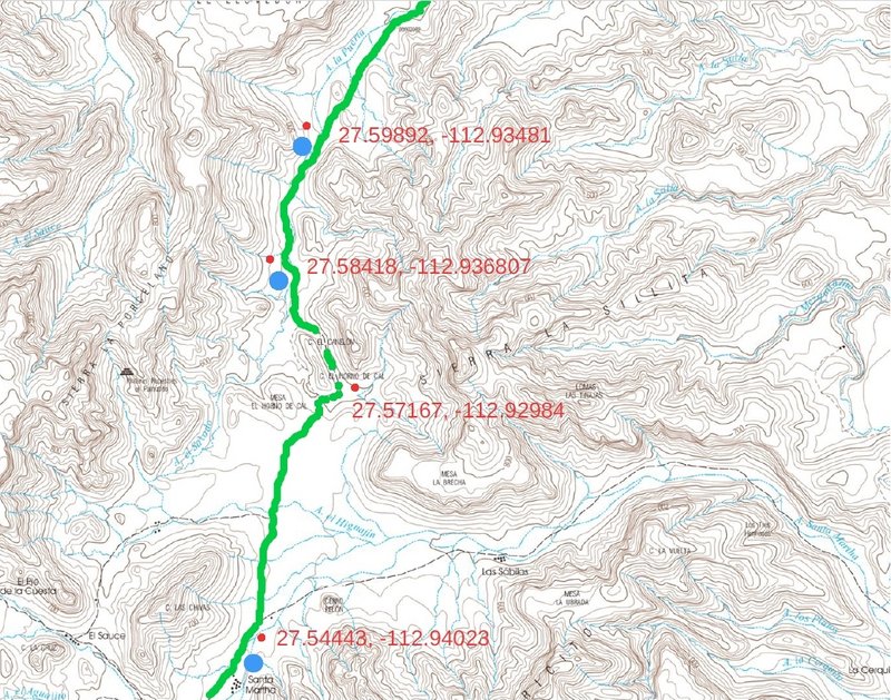
Very nice! 
Here is part of one, north of Santa Martha, northeast of San Ignacio:
[Edited on 10-18-2024 by David K]
|
|
|
cupcake
Senior Nomad
Posts: 847
Registered: 4-23-2024
Member Is Offline
|
|
Thanks David. The Caltopo website you directed me to, is great in that GPS coordinates are displayed for any location that the computer mouse cursor
is moved to. The free maps I downloaded are at 200 DPI. Apparently, if one pays an annual fee of $50, it is possible to get 400 DPI resolution
downloads.
I bought a Garmin ETREX 22X GPS device. I can foresee me possibly having problems in using my map GPS marks to verify that I am still on route. I am a
newbie to GPS use; hopefully I will learn enough to make my GPS device, in conjunction with my marked topo maps, a good navigation system. I want to
use the GPS at its most basic; I believe some people call it 'breadcrumbs'. I will have a compass as well, so hopefully can keep from getting lost. I
may be required to hire a guide anyway, but it will be good to see how my use of the GPS turns out, in any event.
[Edited on 10-19-2024 by cupcake]
|
|
|
cupcake
Senior Nomad
Posts: 847
Registered: 4-23-2024
Member Is Offline
|
|
Harald has been a wonderful source of information for water sources on the route. He has been very generous in sharing his data, advising on which
water sources may now be dry and which ones are likely still reliable. Thanks Harald!
|
|
|
PaulW
Ultra Nomad
Posts: 3113
Registered: 5-21-2013
Member Is Offline
|
|
Cupcake
Using a Garmin etrex 22x:
you can import a GPX file to a Garmin eTrex 22x by transferring the file to the device's GPX folder
How to get a gpx file
1) Have some one send you the file
2) Make your own file
a) Go to Google Earth and use “add a path” and make the track
b) The save the file as a kml file
c) Go to the web and convert it to a gpx file
d) follow instructions on the first line above.
Many trails and roads are clearly visible on Google Earth for you to make a path from.
Once you make the path it will contain all the track points on your gps you want.
|
|
|
cupcake
Senior Nomad
Posts: 847
Registered: 4-23-2024
Member Is Offline
|
|
Thanks PaulW.
I just downloaded the Garmin 22X Owner's Manual, and I will be reading through it as I familiarize myself with the device.
The critical thing for me, was to be able to take a GPS reading of locations along the way, and this seems easy enough to do. I was pleasantly
surprised to see that each GPS location reading, or waypoint, that my device takes, also has an elevation in feet. I wasn't expecting that, as I was
told that this model has no altimeter. Maybe the device calculates elevation in a different manner? In any even, the elevations it has given thus far
have been accurate.
|
|
|
David K
Honored Nomad
Posts: 65581
Registered: 8-30-2002
Location: San Diego County
Member Is Offline
Mood: Have Baja Fever
|
|
| Quote: Originally posted by cupcake | Thanks PaulW.
I just downloaded the Garmin 22X Owner's Manual, and I will be reading through it as I familiarize myself with the device.
The critical thing for me, was to be able to take a GPS reading of locations along the way, and this seems easy enough to do. I was pleasantly
surprised to see that each GPS location reading, or waypoint, that my device takes, also has an elevation in feet. I wasn't expecting that, as I was
told that this model has no altimeter. Maybe the device calculates elevation in a different manner? In any even, the elevations it has given thus far
have been accurate. |
Yes, it uses the distance to the satellites and the distance from them to sea level to calculate your elevation. It is pretty accurate and no need for
barametic pressure adjustment.
|
|
|
4x4abc
Ultra Nomad
Posts: 4456
Registered: 4-24-2009
Location: La Paz, BCS
Member Is Offline
Mood: happy - always
|
|
| Quote: Originally posted by PaulW | Cupcake
Using a Garmin etrex 22x:
you can import a GPX file to a Garmin eTrex 22x by transferring the file to the device's GPX folder
How to get a gpx file
1) Have some one send you the file
2) Make your own file
a) Go to Google Earth and use “add a path” and make the track
b) The save the file as a kml file
c) Go to the web and convert it to a gpx file
d) follow instructions on the first line above.
Many trails and roads are clearly visible on Google Earth for you to make a path from.
Once you make the path it will contain all the track points on your gps you want. |
I'll be happy to provide the entire track
plus whatever waypoints you like
I hate Garmin products, but now you are stuck with it
I would highly recommend to spend as much time as possible on Google Earth (desktop version) and follow the trail.
There are long sections where the trail has been washed away. Since those sections often are not used by locals or animals - there is no path to
follow. It will be bushwhacking until you pick up the established trail again.
I would highly recommend to mark those points where the trail disappears and comes back up again. Otherwise you might be bushwhacking parallel to the
trail unnecessarily.
I'll be happy to mark those in/out points for you.
Then you transfer them into your GPS.
They won't do you any good on the paper map.
I have done this section with locals guides.
It is fun and relatively easy.
But you could also get lost at a heartbeat.
if you do the trail alone - get an inReach device. The cheapest one will do.
[Edited on 10-20-2024 by 4x4abc]
Harald Pietschmann
|
|
|
| Pages:
1
2
3
..
6 |


