Lance S.
Nomad

Posts: 237
Registered: 2-16-2021
Member Is Offline
|
|
Sauer and Miegs 'Site and Culture at San Fernando de Velicata ' 1927
Sauer and Miegs 'Site and Culture at San Fernando de Velicata ' now available online.
https://babel.hathitrust.org/cgi/pt?id=uc1.31822043018266&am...
[Edited on 6-24-2025 by Lance S.]
|
|
|
David K
Honored Nomad
Posts: 65562
Registered: 8-30-2002
Location: San Diego County
Member Is Offline
Mood: Have Baja Fever
|
|
Thank you very much!
I knew Meigs was there and wrote about it but as it wasn't a Dominican founded mission the details were missing from his popular book.
Too bad as the Franciscans were at San Fernando for only four years. Most of what we see was from the Dominicans.
Meigs data has appeared in other works.
San Fernando was the first mission I camped at (1974) and was the most recent one revisited (last month). Thanks again.
|
|
|
geoffff
Senior Nomad
Posts: 721
Registered: 1-15-2009
Member Is Offline
|
|
To download the full PDF, go directly to google books
https://www.google.com/books/edition/Site_and_Culture_at_San...
And click on the three dots in the black control with the title and authors at the upper-left.
|
|
|
David K
Honored Nomad
Posts: 65562
Registered: 8-30-2002
Location: San Diego County
Member Is Offline
Mood: Have Baja Fever
|
|
Thanks Geoff.
Any other old books about Baja history available like this, please pass along.
For my web page on Pozo de San Francisquito (near Coco's new Corner), I would like to read from others who were on the Serra-Portola expedition to San
Diego, if they mentioned the water source.
I have Serra's translated & Spanish diary, but the book I saw on Portola's diary begins at Mission Santa María, which is a day's ride AFTER San
Francisquito (called 'San Francisco' by Serra).
I also haven't seen the diaries of Juan Crespí or José de Cañizares before they reached Valicatá (San Fernando mission site). They were in the
first group to go to San Diego, over a month before Serra's ride.
Many thanks to you or any others who would care to assist.
My San Francisquito page: https://vivabaja.com/pozo-san-francisquito/ has the Serra 1769 diary, the 1792 Longinos road log, North's 1906 description, and Gulick's 1954 El
Camino Real paper mention.
|
|
|
Lance S.
Nomad
Posts: 237
Registered: 2-16-2021
Member Is Offline
|
|
Here's the description of San Francisco from Itinerarios
Sachsen.Digital: Itinerarios y derroteros de la Republica Mexicana https://share.google/m4p35qrwVZzoA6Vg7
Vicente Mora mentions yubay on his trip north to San Fernando, don't remember if he mentions San Francisco. I will see if I can find it.
[Edited on 6-27-2025 by Lance S.]
|
|
|
Don Jorge
Senior Nomad
Posts: 681
Registered: 8-29-2003
Member Is Offline
|
|
Quote: Originally posted by Lance S.  | Here's the description of San Francisco from Itinerarios
Sachsen.Digital: Itinerarios y derroteros de la Republica Mexicana https://share.google/m4p35qrwVZzoA6Vg7
Vicente Mora mentions yubay on his trip north to San Fernando, don't remember if he mentions San Francisco. I will see if I can find it.
[Edited on 6-27-2025 by Lance S.] |
Very cool. Learned a new Spanish word browsing the link, "leguas" leagues in English, the distance a man could walk in an hour. Of course that
varies as in was I a 30 year old man or a 71 one year old man. Guess you could say I've switched leagues so to speak, as many of us here have
switched leagues I'm guessing, haha.
Thanks for posting this Lance.
[Edited on 6-27-2025 by Don Jorge]
�And it never failed that during the dry years the people forgot about the rich years, and during the wet years they lost all memory of the dry
years. It was always that way.�― John Steinbeck
"Until a person learns to respect nature and talk to the animal world, he will never know his true role on Earth." Enzo Mallorca
"Nature bats last." Doug "Hayduke" Peac-ck
|
|
|
David K
Honored Nomad
Posts: 65562
Registered: 8-30-2002
Location: San Diego County
Member Is Offline
Mood: Have Baja Fever
|
|
| Quote: Originally posted by Lance S. | Here's the description of San Francisco from Itinerarios
Sachsen.Digital: Itinerarios y derroteros de la Republica Mexicana https://share.google/m4p35qrwVZzoA6Vg7
Vicente Mora mentions yubay on his trip north to San Fernando, don't remember if he mentions San Francisco. I will see if I can find it.
[Edited on 6-27-2025 by Lance S.] |
Thank you!
I found another online version of the 1856 guide, with a Google translation feature:
Here is the entry for San Francisquito (9 leagues from Calamajué and 12 from Santa María): https://www.google.com/books/edition/_/J4VUUDoXXMEC?hl=en&am...
>>>San Francisco the land goes up until it passes through a small mountain range of large loose stones that gives way to another plain and
from this to the San Francisco stream that is nine leagues from the starting point. The water of San Francisco is bad, it does not quench thirst, it
increases it and is harmful, like the one that is in San Andrés.<<<
FYI, here is the next entry (Santa María) that begins describing the El Camino Real both the original canyon route "Cajon" of Serra's diary and the
replaced trail that stays out of the canyon:
>>>Santa Maria continues along the path passing over the rocks looking for the stream following it until it comes out onto the plain where
some pronghorn can often be seen. Leaving the stream, it climbs a stony table with uneven terrain interrupted by some dry streams from which point the
port of San Luis can be seen along the extensive plain through the center of which the San Francisco stream runs until it flows into the sea with the
Santa Maria stream. This plain is somewhat grassy and descends to the Santa Maria stream about two leagues from the gulf. In the past, the path
followed the stream up but during the day it has very difficult passages and water is often found between the rocks. Now the path crosses the stream
and climbs the long and difficult slope of Santa Maria, stony and with difficult passages about two leagues long. that goes down to the stream. On the
left side of the hills you reach the ruined mission of Santa María, where the Jesuits arrived. It has no farmland. There is good mezcal, palm heart
and taco palm, whose fruit is purgative. There are springs of good water and some grass in the stream. There are no inhabitants.<<<
|
|
|
David K
Honored Nomad
Posts: 65562
Registered: 8-30-2002
Location: San Diego County
Member Is Offline
Mood: Have Baja Fever
|
|
Calamajué entry, the one just before San Francisco:
Calamajue means hot water follows the Yubai road through good grassy terrain called the plains of Santa Ana until you go down to the Calamajue stream
and walk along it for about two leagues until you find water. The rumor is very valid that there are many good mines here, slate and sharpening stones
abound. In parts, a little bad water runs, there is a lot of thermal water and some good water too. The stream is long and the road continues along it
and before leaving it, you find a spring called the volcano, which consists of three holes about six inches in diameter that are found on a substance
that is already petrified, over which the bubbles that come out spill and leave a white substance similar to the salt of England. This water comes out
hot in winter. From this point to the gulf there will be four leagues. You leave this stream going up to the left to a plain from which the ruins of
the mission can be seen behind you. This grassy and extensive plain is called the Hernandes mines. Here you can clearly distinguish The path traced by
the Jesuits The mountain range that is carried to the left is assured to be very rich and there is a waterhole in one of the two ravines that it has.
This plain ends in some isolated hills through which one passes to enter by a stream into a narrow ravine from which some good mineral stones have
been extracted.
|
|
|
Lance S.
Nomad
Posts: 237
Registered: 2-16-2021
Member Is Offline
|
|
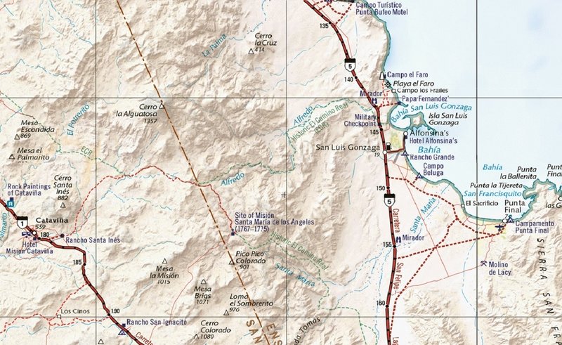
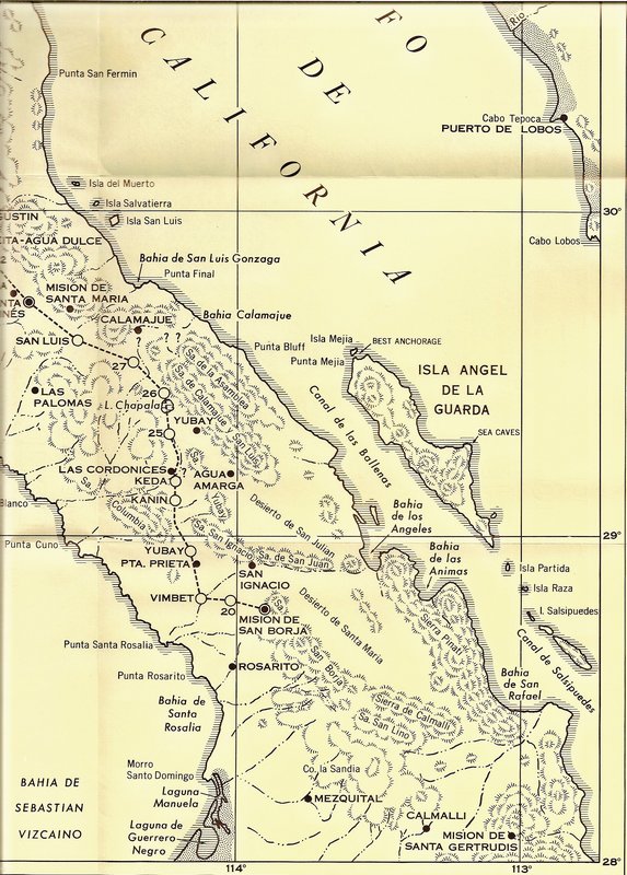
So there were three trails total to Santa Maria? Two in the canyon and the cargo trail that went up Arroyo San Luis (Alphonso)?
Is Los Frailes (in Arroyo San Luis/Alphonso) a deep drilled well?
If so, was this the closest water to the port during the mission period? 29°46'34"N 114°32'36"W
If the San Luis rancheria (Links Mission of San Luis) is over there somewhere then there may have been a bit of a cover up. They pretty much ended up
back where they started when they moved the cabacera to Santa Maria?
[Edited on 6-27-2025 by Lance S.]
[Edited on 6-27-2025 by Lance S.]
|
|
|
David K
Honored Nomad
Posts: 65562
Registered: 8-30-2002
Location: San Diego County
Member Is Offline
Mood: Have Baja Fever
|
|
Good morning, Lance...
The three routes are:
1) Cajon/ Caxon= Santa María Canyon
2) Post 1769 replacement ECR, on the north rim of the canyon.
3) Antelope Spring Trail, aka "Serra's Cargo Trail" which is north of the mission and made to move supplies from the warehouse on Bahía San Luis
Gonzaga to the new missions of San Fernando and beyond.
Pozo de los Frailes, just north of Papa Fernandez' is not too deep. Likely dug where the Natives had a hand dug well.
Linck's San Luis is a bit of a mystery and historians have multiple site locations. I have no opinion on it. A curiosity for sure!
|
|
|
David K
Honored Nomad
Posts: 65562
Registered: 8-30-2002
Location: San Diego County
Member Is Offline
Mood: Have Baja Fever
|
|
Both the post-1769 ECR and the 'cargo trail' are shown on the Benchmark Baja Road Atlas.
[Edited on 6-28-2025 by David K]
|
|
|
4x4abc
Ultra Nomad
Posts: 4455
Registered: 4-24-2009
Location: La Paz, BCS
Member Is Offline
Mood: happy - always
|
|
| Quote: Originally posted by Lance S. | So there were three trails total to Santa Maria? Two in the canyon and the cargo trail that went up Arroyo San Luis (Alphonso)?
|
correct - 3 trails
Arroyo San Luis/Arroyo Alfredo
Harald Pietschmann
|
|
|
4x4abc
Ultra Nomad
Posts: 4455
Registered: 4-24-2009
Location: La Paz, BCS
Member Is Offline
Mood: happy - always
|
|
lotsa trails and tracks around Arroyo Santa Maria

Harald Pietschmann
|
|
|
David K
Honored Nomad
Posts: 65562
Registered: 8-30-2002
Location: San Diego County
Member Is Offline
Mood: Have Baja Fever
|
|
The Sat image from Harald shows how supplies got to the mission from the port of San Luis Gonzaga before the shorter "cargo trail" was initiated by
Junípero Serra.
|
|
|
4x4abc
Ultra Nomad
Posts: 4455
Registered: 4-24-2009
Location: La Paz, BCS
Member Is Offline
Mood: happy - always
|
|
| Quote: Originally posted by Don Jorge |
Very cool. Learned a new Spanish word browsing the link, "leguas" leagues in English, the distance a man could walk in an hour. Of course that
varies as in was I a 30 year old man or a 71 one year old man. Guess you could say I've switched leagues so to speak, as many of us here have
switched leagues I'm guessing, haha.
Thanks for posting this Lance.
[Edited on 6-27-2025 by Don Jorge] |
leguas go back to the Romans
but like many old measurement units - the same name did not mean the same distance
and then each country/province had their own legua
for the Jesuit time in Baja "una legua" was pretty uniformly 4.2 km
however there are some papers where a legua could be whatever the author felt like that day of writing
una legua translates to 5,000 Varas - 0.836 meters
would be interesting to see the plans of missions or even Corrales layed out in Varas instead of meters or feet
that would be a cool project
Harald Pietschmann
|
|
|
David K
Honored Nomad
Posts: 65562
Registered: 8-30-2002
Location: San Diego County
Member Is Offline
Mood: Have Baja Fever
|
|
When Harald and I worked on the map of the Atondo-Kino route (Gulf to the Pacific, in 1684, Admiral Atondo's leagues varied a lot.
https://vivabaja.com/atondo-kino/
This note is on the page:
*a league is the distance traveled in one hour on horseback or (typically) 2-3 miles. The Atondo diary book translator says a league is 3 miles and
Harry Crosby in his Antigua California says it is 2.5 miles. In fact, Atondo likely over-estimated his leagues which usually are closer to 2 miles, or
less!
|
|
|
Lance S.
Nomad
Posts: 237
Registered: 2-16-2021
Member Is Offline
|
|
Link kept remarkably close to one league per hour between San Borja and San Fernando. When he enters rougher country after San Juan de Dios he still
gives hours but lets the reader know he is not traveling as fast as usual. Once he is on the east side of the divide climbing in and out of canyons
he stops giving hours altogether.
|
|
|
David K
Honored Nomad
Posts: 65562
Registered: 8-30-2002
Location: San Diego County
Member Is Offline
Mood: Have Baja Fever
|
|
| Quote: Originally posted by Lance S. | | Link kept remarkably close to one league per hour between San Borja and San Fernando. When he enters rougher country after San Juan de Dios he still
gives hours but lets the reader know he is not traveling as fast as usual. Once he is on the east side of the divide climbing in and out of canyons
he stops giving hours altogether. |
I have the 1766 Linck Expedition Maps at https://VivaBaja.com/maps from the Dawson Book on it (#5)... the dates (numbers) are for the northward leg... (20 = Feb. 20, 1766)
The author/ translator of Linck's diary (Father Ernest Burrus, S.J.) may have misunderstood Yubay (comparing the placement of Linck's mention and the
true Yubay, in a different place). Also, San Ignacio (a visita of San Borja, called San Ignacito now) is west of San Borja, not north. Rosarito seems
too far south or maybe San Borja is just placed badly? The map shows 'San Luis' in an unlikely place, too. The map was made by Ronald L. Ives.
|
|
|
Lance S.
Nomad
Posts: 237
Registered: 2-16-2021
Member Is Offline
|
|
Agreed, Ives route has some problems. Links route ran San Borja-Agua Amarga-Yubay-Agua Leon-Codornices.
When Link reaches Jaraguay he seems to be saying that he has reached the territory called San Luis rather than the rancheria with that name. Ives
marked it as the rancheria.
Then again he could be saying he has arrived at the rancheria.
In that case it's Jaraguay.
[Edited on 7-1-2025 by Lance S.]
|
|
|
Lance S.
Nomad
Posts: 237
Registered: 2-16-2021
Member Is Offline
|
|
Del Barco's passage on Juan Nepumoceno, chieftain of San Luis. Contains some interesting stuff not included in Clavigero.
Of those who had been baptized in San Borja, and who should have belonged, according to their territories, to the new mission, a little over fifty
went there with the priests, among whom was the principal one named Juan Nepomuceno, who deserves special mention here. Being a nobleman, with his
courage and intrepidity, he had made himself lord (or uavai, as they say, that is, guaguai) of his large rancheria, which was later called San Luis
Gonzaga. He waged war on other rancherias, with such success that he took the lives of most of them, so that only those few who were able to flee and
escape from his hands and those of their own people remained alive. We do not know anything certain about the cause of these hostilities. It was said
that this man was one of those who, being Gentiles, wanted to prevent the baptism of others closer to them at the mission of San Borja, who were
trying to become Christians, and, unable to hinder it otherwise, killed them, as mentioned in chapter III. But if John of Nepomuk was one of these,
the Christians did not catch him when they attacked them, imprisoned them, and took them to San Borja. The truth is that with these and similar
exploits he had struck terror into all the people of those territories. He was married (as a man of high authority) to two wives, by whom he had
children. When God used his mercy on him, calling him to his knowledge and faith, he went to San Borja alone, without his wives or children, to ask
for baptism, which he received after the usual instruction and after his constancy was proven. From San Borja he sent for his wives and children to
come to Adac and become Christians. They did so, and in due time they were baptized, and Juan Nepomuceno married one of the two according to the
Catholic rite. Accompanying this family, they arrived in San Borja about seventy Gentiles, who were gradually baptized. In addition to what has been
said, Father
Victoriano Arnés (who later served as his missionary at the new mission of Santa María) adds the following, speaking of this Nepomucene: "This
captain was very famous for his courage and the destruction he wreaked on several settlements, even though he was a Gentile. And, after being
baptized, he made himself obeyed by many Christians who made up his settlement and respected by the Gentiles. He behaved well, so much so that at the
mission of Santa María, he and his settlement were the most helpful in every difficult situation and the ones who helped most with the necessary work
of the new foundation, and those who were bringing other settlements to baptism."
|
|
|


