| Pages:
1
2 |
David K
Honored Nomad
        
Posts: 65364
Registered: 8-30-2002
Location: San Diego County
Member Is Offline
Mood: Have Baja Fever
|
|
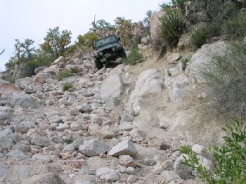
The road to Mision Santa Maria at mi. 13.3
Affectionately named 'The Widow Maker', this grade is only really tough when you are leaving, going up!
[Edited on 6-25-2005 by David K]
|
|
|
David K
Honored Nomad
        
Posts: 65364
Registered: 8-30-2002
Location: San Diego County
Member Is Offline
Mood: Have Baja Fever
|
|
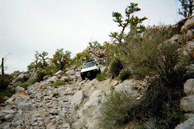
Chicagoross coming down (4-03)

|
|
|
David K
Honored Nomad
        
Posts: 65364
Registered: 8-30-2002
Location: San Diego County
Member Is Offline
Mood: Have Baja Fever
|
|
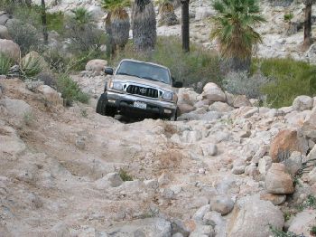
Fishuntr coming down (Toyota truck)

|
|
|
David K
Honored Nomad
        
Posts: 65364
Registered: 8-30-2002
Location: San Diego County
Member Is Offline
Mood: Have Baja Fever
|
|
Here I am 2 days later, climbing up The Widow Maker!

|
|
|
pokey
Nomad
 
Posts: 199
Registered: 5-20-2005
Location: ensenada
Member Is Offline
Mood: sun burned
|
|
David thats a wild looking path. Have you done that in your Toyota? chit... I been on some hair raising roads in the back country but none that
hairy. The only thing it's missing is a 200 ft cliff. 
Edit: oops! yeah I guess your truck has been through that
[Edited on 6-24-2005 by pokey]
Keep Mexico weird
|
|
|
David K
Honored Nomad
        
Posts: 65364
Registered: 8-30-2002
Location: San Diego County
Member Is Offline
Mood: Have Baja Fever
|
|
Ha ha YES!
See all the photos from that trip http://vivabaja.com/403
Baja Mur has some good ones of the road on his page from when we went in, in 1999: http://bajamur.homestead.com/index.html
|
|
|
Bob H
Elite Nomad
     
Posts: 5867
Registered: 8-19-2003
Location: San Diego
Member Is Offline
|
|
I sure as "heck" would not take my cab-over on that road! Wow.
The SAME boiling water that softens the potato hardens the egg. It's about what you are made of NOT the circumstance.
|
|
|
Bruce R Leech
Elite Nomad
     
Posts: 6796
Registered: 9-20-2004
Location: Ensenada formerly Mulege
Member Is Offline
Mood: A lot cooler than Mulege
|
|
thanks David for the good off roding pictures. give us some moor details about that trip.
Bruce R Leech
Ensenada
 |
|
|
David K
Honored Nomad
        
Posts: 65364
Registered: 8-30-2002
Location: San Diego County
Member Is Offline
Mood: Have Baja Fever
|
|
If you get a copy of the last Discover Baja newsletter, you can read my story about the trip, which featured finding 'Inky' the lost dog about 8 miles
east of Santa Ynez.
It was Spring break (April), 2003... Fishuntr & Linda, Chicagoross & Rose, Sarah & I... were the three vehicle groups going in... See http://vivabaja.com/403
The 14.5 mile road took us 2 hours and 35 minutes to drive (with photo stops).
The first tough 4WD grade is only 1.8 mi. from Santa Ynez and is a great filter to prevent the unskilled or under equiped from traveling any further.
9.9 miles from Santa Ynez is the high point, or peninsular divide where you can see Punta Final and the Sea of Cortez (Gonzaga Bay).
Then it is all down hill to the mission valley and the road gets tough winding through the boulders.
13.3 mi. from Santa Ynez is the top of the Widow Maker grade, just 1.2 miles from the mission. Many park here and walk the rest of the way ('girlie
men').
The road drops into the palm grove and stream at the bottom of the grade and you drive in the water a ways before climbing out to go over one last
rock ridge to the next valley over that contains the mission... 14.5 miles from Santa Ynez.
So, who's up for this, next month?
[Edited on 6-24-2005 by David K]
|
|
|
bajaruby
Banned
Posts: 204
Registered: 6-8-2004
Member Is Offline
|
|
GREAT PICTURES! 
Can't wait to get down there, Looks beautiful. Is it all like that or just that one area?
bajaruby
|
|
|
yankeeirishman
Banned
Posts: 1070
Registered: 3-5-2004
Location: Kalifornia
Member Is Offline
|
|
David..........
This place is above Gonzada Bay, I read. Can you post a map that you can pin point the entrance road to this place (Gonzada being the referance point
.a.)? I dont remember seeing any road to this area..... I must have been too busy changing tires on the road to Coco's! Oh....Nicky loved the
pictures, as I did too. Great post
What control freaks there are here. Don\'t believe that post you just read!
|
|
|
David K
Honored Nomad
        
Posts: 65364
Registered: 8-30-2002
Location: San Diego County
Member Is Offline
Mood: Have Baja Fever
|
|
The 'road' is from Hwy. 1 at Catavina and Rancho Santa Ynez (Ines)... Only way to get there (directly) from Gonzaga is by foot or mule, on EL CAMINO
REAL See: http://www.southcoastfarms.com/gonzaga_to_mission_santa_mari...
I had fun with Chris hiking on it too: http://vivabaja.com/1103 but we got too late a start to make it all the way to the mission that day.
Here I am that day, between Gonzaga and Santa Maria...
(GONZAGA  ) )
[Edited on 6-25-2005 by David K]
|
|
|
David K
Honored Nomad
        
Posts: 65364
Registered: 8-30-2002
Location: San Diego County
Member Is Offline
Mood: Have Baja Fever
|
|
Pilots Map... note the mission symbol between 'Santa Ynez' and 'Molino de Lacy' on the map.
[Edited on 6-25-2005 by David K]
|
|
|
David K
Honored Nomad
        
Posts: 65364
Registered: 8-30-2002
Location: San Diego County
Member Is Offline
Mood: Have Baja Fever
|
|
| Quote: | Originally posted by bajaruby
GREAT PICTURES! 
Can't wait to get down there, Looks beautiful. Is it all like that or just that one area?
bajaruby |
Hi Ruby, look at this web page for photos along the road... the panorama at the mission is great, too. There are palms along the way in a couple
places, but mostly boojums and boulders! >>> http://bajamur.homestead.com/index.html
|
|
|
David K
Honored Nomad
        
Posts: 65364
Registered: 8-30-2002
Location: San Diego County
Member Is Offline
Mood: Have Baja Fever
|
|
Lower Ca Guidebook map (1962 by Howard Gulick)...
[Edited on 6-25-2005 by David K]
|
|
|
fishuntr
Junior Nomad

Posts: 29
Registered: 10-7-2002
Location: So. Calif. High Desert
Member Is Offline
|
|
I went on that trip and it was great. At the time I was running 30" tires and would have had a very hard time coming out if not for a front locker.
I have 31" tires now, a little better.
Something David failed to mention, was when we were feeling like bad=a## 4 wheelers, about 30 more Toyotas from old FJ40's to brand new Tacos came in
and camped nearby. It was a club from San Diego. They were well led and at least one or two elected to walk in from the top of "widow maker". When?
David? I want to do it again.
Do the best you can and enjoy your life
|
|
|
David K
Honored Nomad
        
Posts: 65364
Registered: 8-30-2002
Location: San Diego County
Member Is Offline
Mood: Have Baja Fever
|
|
Right after the Baja Rosario Cultural Festival! That is July 22-24... So, we go on to the mission on Monday, July 25. The goal is to install a drain
line from inside, out through the doorway and make a berm to prevent water from eroding the doorway and force it into the drain. An INAH rep or two
may be joining us. This was originally Jack Swords' idea, and he was confident that my connections (and yacking) could get something done.
|
|
|
David K
Honored Nomad
        
Posts: 65364
Registered: 8-30-2002
Location: San Diego County
Member Is Offline
Mood: Have Baja Fever
|
|
My map that shows the roads to the Camino Real from Gonzaga Bay.
|
|
|
yankeeirishman
Banned
Posts: 1070
Registered: 3-5-2004
Location: Kalifornia
Member Is Offline
|
|
Oh! I know now right where the road is! Thanks Guru
What control freaks there are here. Don\'t believe that post you just read!
|
|
|
David K
Honored Nomad
        
Posts: 65364
Registered: 8-30-2002
Location: San Diego County
Member Is Offline
Mood: Have Baja Fever
|
|
How would your Land Rover fair, on that road?
|
|
|
| Pages:
1
2 |

