| Pages:
1
2 |
domromer
Newbie
Posts: 13
Registered: 12-25-2007
Location: Oregon
Member Is Offline
|
|
Which way to get there?
If you were driving from Tucson to Baja would you take the mainland route and get the ferry from Guyamas to Santa rosalita or drive to Tecate then
head south? I'm trying to figure out which makes more sense. I'd plan on going to Mulege, La Bay, and La Paz while in Baja
|
|
|
sancho
Ultra Nomad
    
Posts: 2524
Registered: 10-6-2004
Location: OC So Cal
Member Is Offline
|
|
I would definately go thru Calexico/Mexicali
down Mex Hwy 5, turn west on the
Hwy to Ensenada, then down Hwy1
to Mulege, the price of the ferry
with auto from Guaymas,
approx I'm guessing $200-$250
dollars, don't know the ferry site
offhand, but unless you want to take
the ferry ride, I would go down the
baja hwy
|
|
|
Skeet/Loreto
Ultra Nomad
    
Posts: 4709
Registered: 9-2-2003
Member Is Offline
|
|
Dom:
I would take the Ferry Route. I have taken that route more than Several Times, the first before the Road Opened in Baja.
It gives you a chance to see the difference in the People of the Mainland and Baja.
You also may get a chance to see some of the Fish Life on the Sea of Cortez.
My wife and I always took a small Cabin and were very comfortable.
Which ever way you go, Have a Great Trip/
Skeet/Loreto
|
|
|
domromer
Newbie
Posts: 13
Registered: 12-25-2007
Location: Oregon
Member Is Offline
|
|
I'm looking at my map now. Are you talking about going Mexicali to Tecate then to Ensenada? Otherwise taking the 5 south to the 3 to Ensenada looks
like a fair bit of back tracking.
|
|
|
domromer
Newbie
Posts: 13
Registered: 12-25-2007
Location: Oregon
Member Is Offline
|
|
Speaking of the ferry, I keep trying to look at the site but it isn't working. I'm not sure if it's because I'm on a mac.
|
|
|
JZ
Select Nomad
      
Posts: 13592
Registered: 10-3-2003
Member Is Offline
|
|
I'd take the ferry. But I hope you don't get sea sick easy. If you are going in the Winter or Spring there's a good probability you will get some
rough seas.
|
|
|
capt. mike
Elite Nomad
     
Posts: 8085
Registered: 11-26-2002
Location: Bat Cave
Member Is Offline
Mood: Sling time!
|
|
ferry for sure altho i haven't done it.
but that drive over to Tecate will be a long one from tucson.!!
the guad valle is nice to see tho and good vin to sample while goin sur.
formerly Ordained in Rev. Ewing\'s Church by Mail - busted on tax fraud.......
Now joined L. Ron Hoover\'s church of Appliantology
\"Remember there is a big difference between kneeling down and bending over....\"
www.facebook.com/michael.l.goering |
|
|
David K
Honored Nomad
        
Posts: 65404
Registered: 8-30-2002
Location: San Diego County
Member Is Offline
Mood: Have Baja Fever
|
|
Ferry is expensive, so if through Baja Norte:
Stay on I-8 until you get to the Campo exit and go just past Campo to Tecate... then to Ensenada...
Mex. 5 south from Mexicali to the Ensenada (Hwy Mex. 3) to go to Ensenada is going back north needlessly to Ensenada... I-8 is better and free than
Mex. 2-D from Mexicali to Tecate... and no Mexicali city traffic. Tecate is much easier to get through.
I presume you do not want to use the rough dirt road south of San Felipe/ Puertecitos for a tremendous short cut via Gonzaga Bay?
|
|
|
sancho
Ultra Nomad
    
Posts: 2524
Registered: 10-6-2004
Location: OC So Cal
Member Is Offline
|
|
This site may have some info
price of passage with vehicle
$300
http://www.ferrysantarosalia.com/htm/rates.htm
|
|
|
JZ
Select Nomad
      
Posts: 13592
Registered: 10-3-2003
Member Is Offline
|
|
Damn, the ferry is expensive! That's ridulous.
|
|
|
domromer
Newbie
Posts: 13
Registered: 12-25-2007
Location: Oregon
Member Is Offline
|
|
How bad is the dirt road? I've got a subaru with decent clearance and I'm up for some adventure.
How long does the dirt road take?
Is it scenic?
|
|
|
David K
Honored Nomad
        
Posts: 65404
Registered: 8-30-2002
Location: San Diego County
Member Is Offline
Mood: Have Baja Fever
|
|
The dirt road is graded, but very rocky in places... a Subaru will get through no problem, just go slow.
Pavement ends at Puertecitos (55 miles, 1.5 hrs. so of San Felipe).
Rough dirt road surface to Gonzaga Bay, 50 miles, 3 hrs. from Puertecitos (with photo stops, it's beautiful).
Gonzaga Bay Pemex station to Hwy. 1 is 36 dirt miles (1.5 hr.), but better than the previous section, by far.
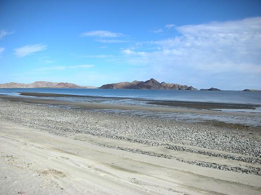
The beaches south of San Felipe are some of the best in Baja, and the giant tide exposes so many sea shells!>>>

Leaving Puertecitos, the road is actually good for the first 8 miles towards Gonzaga because of the mine being worked in the hills, maintaing the
road.>>>

The road does get rougher, however...>>>

The view back north , about 18 miles from Puertecitos.>>>

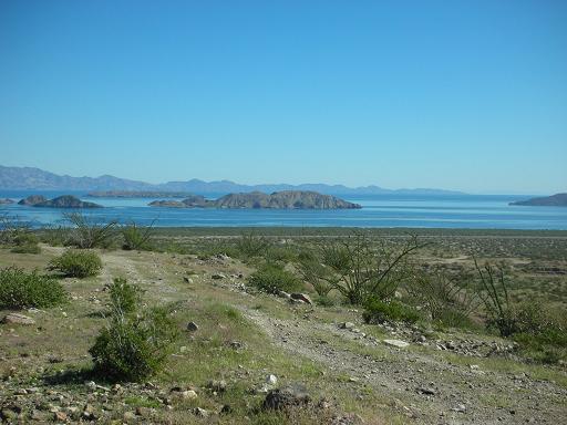
And the view south of the Enchanted Islands.>>>

4WD is not needed, just good tires and slow driving:

Bahia San Luis Gonzaga comes into view...>>>

My web page background photo is Gonzaga Bay: click: http://vivabaja.com
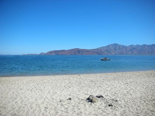
The shore south of San Luis Gonzaga Bay in front of Campo Beluga:

Usually also called 'Gonzaga', this larger bay to Punta Final is actually 'Ensenada de San Francisquito' (but that is a mouthfull!)

South of Gonzaga Bay, a stop at Coco's Corner for a beer and to sign Coco's guest book is a tradition!

The Baja desert is awesome!

A visit to Bahia de los Angeles (41 paved miles from Hwy. 1) is well worth it!:


Viva Baja !!!!
|
|
|
Pappy Jon
Nomad
 
Posts: 494
Registered: 8-27-2003
Location: Wrong side of the Continental divide.
Member Is Offline
Mood: Temp rising.
|
|
If you are going down the Gulf road I would cross at Algodones. I always cross there when they open in the morning, and I'm coming from New Mexico.
It's a little more involved getting to Hwy 5 (BCN2 to BCN3 to BCN4 to Mex 5), but not a big deal. Just watch your speed through those little towns.

"The association of flowers and warm-blooded love is more than a romantic convention; it is based upon one of the great advances in the evolution
of life." Ed Abbey
|
|
|
domromer
Newbie
Posts: 13
Registered: 12-25-2007
Location: Oregon
Member Is Offline
|
|
I did some more research. It looks like we will go San Felip/Gonzaga bay/LA Bay/Mulege. Nice pictures. I'll need to check out your website. Are there
palapas at Gonzaga bay that can be used with tent camping? Also can you get gas and supplies there?
|
|
|
David K
Honored Nomad
        
Posts: 65404
Registered: 8-30-2002
Location: San Diego County
Member Is Offline
Mood: Have Baja Fever
|
|
Yes, Campo Beluga... http://vivabaja.com/207/page3.html
|
|
|
domromer
Newbie
Posts: 13
Registered: 12-25-2007
Location: Oregon
Member Is Offline
|
|
Do you get a lot of flats on the from San Felipe? My Subaru just has normal street tires. I can't any all terrains for it. I was thinking of carrying
an extra spaire on the roof.
|
|
|
David K
Honored Nomad
        
Posts: 65404
Registered: 8-30-2002
Location: San Diego County
Member Is Offline
Mood: Have Baja Fever
|
|
| Quote: | Originally posted by domromer
Do you get a lot of flats on the from San Felipe? My Subaru just has normal street tires. I can't any all terrains for it. I was thinking of carrying
an extra spaire on the roof. |
New or almost new tires would be key. Having a good tire (or at least a tire in good condition) is important, sure. Go slow...
Tire repaires or used replacements have been available at Rancho Grande (Gonzaga Bay) in the past... the tire shop is behind the store (where you can
buy food items, water, booze).
I posted several photos above, if that is something that interests you, then you will enjoy the journey no mater how bad the road.
Photo of my Subaru on the beach where we camped (Punta San Francisquito)... Subaru got me everywhere in Baja in the late 70's and 80's.

|
|
|
losfrailes
Senior Nomad
  
Posts: 577
Registered: 11-16-2004
Location: Ejido San Lucas near Santa Rosalia
Member Is Offline
Mood: Good!
|
|
At the present time, wind conditions being what they are and projected, you will find the Ferry is not running. So regardless of the cost, you would
be well advised to make the drive.
Further advice, altho the road to San Felipe is wonderful, consider the road across the peninsula to Laguna Chapala. It has been know to wreck more
than one suspension system.
Best shot is to continue to Tecate and then drive down Mex 1. Road is paved and in generally excellent condition the entire way.
|
|
|
Phil S
Super Nomad
   
Posts: 1205
Registered: 10-28-2003
Member Is Offline
Mood: After 34 years. Still in love w/ my wife
|
|
Having made the trip into Baja from Tijuana, Otay, Tecate & Mexicali I'd suggest if your driving with just "normal tires" and don't want to buy
new ones for this trip, that you will probably find going through Tecate your best entrance. Couple years ago we drove to San Felipe to Gonzaga Bay,
through Coco's Corner over to highway one. Ended up I had to replace two tires because of the "razor" rocks on part of the 'climb' in one area.
You'll read older comments regarding the 'razor rocks' in prior comments several years ago. In case of break downs for whatever reasons, I'd rather
be on highway 1. Going that way you'll "experience" it all!!!!!
Have a safe trip. Don't drive at nights because of the 'critters'. Fourlegged ones & maybe even some two legged ones. Report back when you return
to Tucson.
|
|
|
BajaTrooper
Junior Nomad

Posts: 57
Registered: 3-5-2007
Location: somewhere cold and wet
Member Is Offline
|
|
| Quote: | Originally posted by domromer
I did some more research. It looks like we will go San Felip/Gonzaga bay/LA Bay/Mulege. Nice pictures. I'll need to check out your website. Are there
palapas at Gonzaga bay that can be used with tent camping? Also can you get gas and supplies there? |
|
|
|
| Pages:
1
2 |

