| Pages:
1
2 |
Ken Cooke
Elite Nomad

Posts: 8971
Registered: 2-9-2004
Location: Riverside, CA
Member Is Offline
Mood: Pole Line Road postponed due to injury
|
|
Real big 4WD convoy - TJ to GN 11.22-
So far, we're looking at 10 vehicles. Not bad, considering the current downturn. If you want a safe convoy from TJ through San Felipe/Tecate or
south Hwy 5, etc., we're heading south on Saturday the 22nd of Nov. and we're traveling towards Tecate/El Hongo (for gas), then to San Felipe for the
night.
::Safety in numbers::

|
|
|
David K
Honored Nomad
Posts: 65561
Registered: 8-30-2002
Location: San Diego County
Member Is Offline
Mood: Have Baja Fever
|
|
A new Pemex was U.C. just east of Tecate near where you join the toll highway. If El Hongo is out, then try La Rumorosa... But remamber the Baja 1000
is running the 21 & 22 and all the support and spectator vehicles will likely be draining the Pemex storage tanks since the 1000 passes through La
Rumorosa and San Felipe!
Caravans that big may take a half hour to fill up!
Gas is now in the $2.70's per gallon around here, perhaps topping off in El Cajon before entering at Tecate... or going straight to Calexico (fill up
there) for a far easier and faster jump on San Felipe to avoid the mobs and gas lines along Hwy. 2 ??? Hope for gas at San Felipe... if not, or too
long lines, then Puertecitos, Gonzaga Bay, L.A. Bay have Pemex and no Baja 1000 mobs...
Good luck!!!
|
|
|
Ken Cooke
Elite Nomad
Posts: 8971
Registered: 2-9-2004
Location: Riverside, CA
Member Is Offline
Mood: Pole Line Road postponed due to injury
|
|
| Quote: | Originally posted by David K
A new Pemex was U.C. just east of Tecate near where you join the toll highway. If El Hongo is out, then try La Rumorosa... But remamber the Baja 1000
is running the 21 & 22 and all the support and spectator vehicles will likely be draining the Pemex storage tanks since the 1000 passes through La
Rumorosa and San Felipe!
Caravans that big may take a half hour to fill up!
Gas is now in the $2.70's per gallon around here, perhaps topping off in El Cajon before entering at Tecate... or going straight to Calexico (fill up
there) for a far easier and faster jump on San Felipe to avoid the mobs and gas lines along Hwy. 2 ??? Hope for gas at San Felipe... if not, or too
long lines, then Puertecitos, Gonzaga Bay, L.A. Bay have Pemex and no Baja 1000 mobs... |
I'm not worried about Baja 1000 mobs. Typically, the group fills up on gas while everyone else finds a place to grab a fast bite of food. El Hongo
should be a good bet - if not, the other side of Laguna Salada - El Progreso has gas, and plenty of taco stands across the street (at the
intersection).
San Felipe should be no problem - 1/2 hour minimum for large groups, but no big deal, we're topping off our gerry cans, buying beer, soda, wine, etc.
Gonzaga Bay requires visiting with the caretaker, getting him to open up the Pemex for our use, and then, heading to LA Bay for more gas. Once again,
keeping our gerry cans topped in case things get thin with regard to gas. Thanks for the advice...
|
|
|
David K
Honored Nomad
Posts: 65561
Registered: 8-30-2002
Location: San Diego County
Member Is Offline
Mood: Have Baja Fever
|
|
Have a fun time Ken!
You did see my posts about using the original road south of L.A. Bay, yes?
|
|
|
Ken Cooke
Elite Nomad
Posts: 8971
Registered: 2-9-2004
Location: Riverside, CA
Member Is Offline
Mood: Pole Line Road postponed due to injury
|
|
| Quote: | Originally posted by David K
Have a fun time Ken!
You did see my posts about using the original road south of L.A. Bay, yes? |
Disculpe, David. Pero, no supe nada como un camino al sur de bahia de los Angeles. Dime la direccion pa la info., amigo.
|
|
|
David K
Honored Nomad
Posts: 65561
Registered: 8-30-2002
Location: San Diego County
Member Is Offline
Mood: Have Baja Fever
|
|
Well, it is in the Almanac for visual aid...
Bahia San Rafael (Pancho's) is just off to the right of the map.
I have circled sites I have photos of or mentioned with photos. San Pedro ranch is actually La Bocana. You cannot see it or Los Paredones from the
Valle La Bocana road without driving the access roads in.
Tinaja Santa Maria and La Bocana are on the eastern branch of the Camino Real to San Borja from Santa Gertrudis... sometimes called the Gulfo Camino
Real. Some of it can be seen on the satellite images in Valle San Pedro.
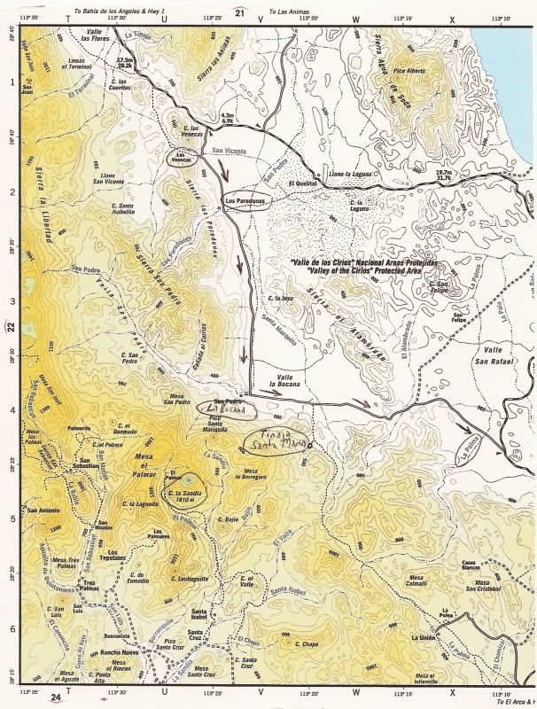
Here are some GPS directions from various times I have traveled it:
GPS DIRECTIONS: L.A. BAY & SOUTH (Map datum at WGS 84)
From our 7-4-01 Lost Mission Hunt trip:
Casa Diaz, Bahia de los Angeles: N28°56.77' W113°33.55'
Camp Gecko, south of town: N28°54.05' W113°31.73'
Las Flores (jail house): N28°49.10' W113°31.77'
Jcn. with old road south: N28°40.77' W113°25.45' (turn right here)
Arroyo to Las Venecas: N28°39.40' W113°25.86'
Site of Paredones, Jesus' ranch: N28°36.81' W113°24.59'
Road ahead into canyon to La Bocana & San Pedro, turn sharp left (east): N28°28.40' W113°23.47'
<Ken, ignore the next two waypoints and continue straight for San Francisquito>
We turn right, off road here: N28°28.01' W113°20.46'
Tinaja de Santa Maria: N28°26.09' W113°20.02' or at NAD27: GPS is N28°26.07'/ W113°19.99'

The end of the 'road'. This water hole served travelers on the Gulfo Camino between Santa Gertrudis and San Borja. GPS is N28°26.07'/ W113°19.99'.
Cerro la Sandia is in the distance. This is the same peak seen south from L.A. Bay.
We hiked a half mile further, but this was not the old mission era site. Santa Maria Magdalena is a bit further east.
=============================================
The end of the old road run (4-03):
This is looking north, the old and new L.A. Bay to San Francisquito
road junction at 28°26.05'/ 113°10.41' (map datum at NAD27 Mexico), south of Bahia San Rafael.
Also see this page: http://vivabaja.com/403/page12.html
[Edited on 10-30-2008 by David K]
|
|
|
David K
Honored Nomad
Posts: 65561
Registered: 8-30-2002
Location: San Diego County
Member Is Offline
Mood: Have Baja Fever
|
|
Wikimapia satellite image of region (you can zoom in and see the road, etc.): Valle la Bocana
|
|
|
Debra
Super Nomad
Posts: 2101
Registered: 10-31-2002
Location: Port Orchard Wa./Bahia de Los Angeles BC
Member Is Offline
|
|
Ken, stop by Camp Gecko for a cold one!
Mean people suck!
|
|
|
Ken Cooke
Elite Nomad
Posts: 8971
Registered: 2-9-2004
Location: Riverside, CA
Member Is Offline
Mood: Pole Line Road postponed due to injury
|
|
| Quote: | Originally posted by Debra
Ken, stop by Camp Gecko for a cold one! |
Thanks for the invite. I'll mark this down on our itinerary.
David, Thanks for the great, detailed information. I appreciate it.
|
|
|
David K
Honored Nomad
Posts: 65561
Registered: 8-30-2002
Location: San Diego County
Member Is Offline
Mood: Have Baja Fever
|
|
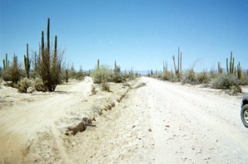
The pleasure is mine... if you detour through Valle La Bocana, you will be on a REAL Jeep road!

Traveling west from San Rafael to Valle la Bocana in search of a lost mission. This was the road opened by the Gardner party almost 40 years ago.
|
|
|
Ken Cooke
Elite Nomad
Posts: 8971
Registered: 2-9-2004
Location: Riverside, CA
Member Is Offline
Mood: Pole Line Road postponed due to injury
|
|
| Quote: | Originally posted by David K
The pleasure is mine... if you detour through Valle La Bocana, you will be on a REAL Jeep road!
Traveling west from San Rafael to Valle la Bocana in search of a lost mission. This was the road opened by the Gardner party almost 40 years ago.
|
That road looks rough! Anything my old Ford could have handled??? 

|
|
|
BAJACAT
Ultra Nomad
Posts: 2902
Registered: 11-21-2005
Location: NATIONAL CITY, CA
Member Is Offline
|
|
Ken so whats up with the BajaGrande shirts???
BAJA IS WHAT YOU WANTED TO BE, FUN,DANGEROUS,INCREDIBLE, REMOTE, EXOTIC..JUST GO AND HAVE FUN.....
|
|
|
David K
Honored Nomad
Posts: 65561
Registered: 8-30-2002
Location: San Diego County
Member Is Offline
Mood: Have Baja Fever
|
|
Read chapters 11 & 12 of Erle Stanley Gardner's 'Off the Beaten Track in Baja' c1967 where he describes the cross country and ancient road
discoveries south of L.A. Bay. Uncle Erle had a new Ford Bronco that made that first trip.
Read chapter 5 of Choral Pepper's 'Baja California: Vanished Missions, Lost Treasures, Strange Stories, True and Tall c1973 where she describes that
same Gardner expedition she was in and the strange wall, dam, fort ruins they found south of L.A. Bay that she later researched and concluded they
very well could have been the site of a mission that was abandoned before being completed... that is shown on the 1757 Jesuit map as 'Santa Maria
Magdalena, started' in that region of Baja.
See the map and photos from Pepper's Desert Magazine at the site: http://vivabaja.com/1757
|
|
|
Ken Cooke
Elite Nomad
Posts: 8971
Registered: 2-9-2004
Location: Riverside, CA
Member Is Offline
Mood: Pole Line Road postponed due to injury
|
|
| Quote: | Originally posted by BAJACAT
Ken so whats up with the BajaGrande shirts??? |
Work has been INSANE lately. I will be working on t-shirts tomorrow and Wednesday - the designs are finished, I'm paying the designer, now I need to
locate a silkscreener in my area that does good work. These shirts will be Baja Proven, and they had better hold up.
I am working at getting the vendor for the shirts tomorrow, and hopefully in 2 weeks, I will have product in hand.
|
|
|
David K
Honored Nomad
Posts: 65561
Registered: 8-30-2002
Location: San Diego County
Member Is Offline
Mood: Have Baja Fever
|
|
Ken, we just got back from Guadalupe Canyon and there are now two Pemex stations (Cuali) along the road leaving Tecate towards Mexicali... in the
Industrial park area... one on the left next to a Circle K type store and another on the right before the toll road entrance.
You do not need to go to El Hongo, or La Rumorosa for gas now... keep everyone together and get to San Felipe sooner!
|
|
|
Ken Cooke
Elite Nomad
Posts: 8971
Registered: 2-9-2004
Location: Riverside, CA
Member Is Offline
Mood: Pole Line Road postponed due to injury
|
|
| Quote: | Originally posted by David K
Ken, we just got back from Guadalupe Canyon and there are now two Pemex stations (Cuali) along the road leaving Tecate towards Mexicali... in the
Industrial park area... one on the left next to a Circle K type store and another on the right before the toll road entrance.
You do not need to go to El Hongo, or La Rumorosa for gas now... keep everyone together and get to San Felipe sooner! |
Our plan is to cross in Tijuana for two reasons; 1. Tourist visas w/bank thats actually open. 2. Pick up 'Nomad CG from his house/neighborhood in
Soler. Therefore, we will be on the toll road, and getting off the toll road to hunt for a gas station will suck the time up. Just like watching 8
or 10 vehicles gas up, use restroom, grab a bite to eat, etc.
This morning, I was looking at Kacey Smith's Off Road GPS Guidebook, and our routes are getting close to completion. That was a great event you
hosted years back, David.
|
|
|
David K
Honored Nomad
Posts: 65561
Registered: 8-30-2002
Location: San Diego County
Member Is Offline
Mood: Have Baja Fever
|
|
Okay Ken, that is news to me... I just remember you saying you were getting gas at El Hongo... I figured you were entering at Tecate, as before.
Fill up in Tijuana and you should get to San Felipe on a tank in the Jeep, right... about 250 miles?
OR... go south to Ensenada then over to San Felipe on Hwy. 3... even better!!
|
|
|
Ken Cooke
Elite Nomad
Posts: 8971
Registered: 2-9-2004
Location: Riverside, CA
Member Is Offline
Mood: Pole Line Road postponed due to injury
|
|
| Quote: | Originally posted by David K
Okay Ken, that is news to me... I just remember you saying you were getting gas at El Hongo... I figured you were entering at Tecate, as before.
|
When the itinerary changed to us entering Baja Sur, we decided on the Yahoo Groups page to enter through Tijuana instead. Tecate's bank wasn't open
on Saturday as we recall, so we changed venues to San Ysidro/Tijuana instead. Better choice since CG will be a ride-along and he lives there in town.
|
|
|
David K
Honored Nomad
Posts: 65561
Registered: 8-30-2002
Location: San Diego County
Member Is Offline
Mood: Have Baja Fever
|
|
Makes perfect sense Ken... The Ensenada-San Felipe highway is sure more casual/ fun/ no toll drive, and with the race using and crossing many parts of
it, more fun for you guys!!! Gas at Ensenada then it's only 150 miles to San Felipe!
|
|
|
Ken Cooke
Elite Nomad
Posts: 8971
Registered: 2-9-2004
Location: Riverside, CA
Member Is Offline
Mood: Pole Line Road postponed due to injury
|
|
| Quote: | Originally posted by David K
Makes perfect sense Ken... The Ensenada-San Felipe highway is sure more casual/ fun/ no toll drive, and with the race using and crossing many parts of
it, more fun for you guys!!! Gas at Ensenada then it's only 150 miles to San Felipe! |
We liked the drive from Tecate to San Felipe. I know the Laguna Salada will be packed with racers as will Hwy 5. But, probably safer than crossing
through the hills. We'll definitely be in San Felipe before dusk.
|
|
|
| Pages:
1
2 |


