| Pages:
1
2 |
bajaandy
Senior Nomad

Posts: 769
Registered: 2-7-2004
Location: North County
Member Is Offline
Mood: Adventurous
|
|
Laguna Chapala to Bahia Blanco
Anybody done this run? I've wanted to make this run for a while now, and I think I'm gonna do it in December, but wanted to know if anybody else has
done it (recently or otherwise!). The roads all seem to connect on Google Earth, but you know how that goes! Anybody else wanna go?
subvert the dominant paradigm
"If you travel with a man, you must either fall out with him or make him your good friend."
JBL Noel
|
|
|
TMW
Select Nomad
Posts: 10659
Registered: 9-1-2003
Location: Bakersfield, CA
Member Is Offline
|
|
Andy it's been a couple of years since I've done it but it's a great drive. The primary road is the turnoff from hwy1 at KM252. You'll pass a couple
of ranchos then go down a long hill that could be a problem from the rains then drop into a wash then back onto a dirt road and out to the coast. The
road in from KM252 is joined by another road from KM271.
The other road in from Chapala is near KM233/234. This was part of the original Baja 1000 course in 2003 but was taken out due to the deep silt beds
after the turn off from the coast. This too is a good road. It passes a dead volcano to the north several miles from hwy1 that David K found on
google. You pass a couple of dry lake beds and if there has been any heavy rain be carefull. You shouldn't have any problems with silt since there has
been very little traffic if any on this road, again unless there's been rain. It comes out at the coast at Playa Christie. There is a cross road maybe
three miles before the coast that will take you to Bahia Blanco and this maybe the best route.
The two routes above make for a good loop off hwy1 in and out. A stop at San Antonio on the first route is interesting with it's plam trees, well and
abandoned buildings.
|
|
|
David K
Honored Nomad
Posts: 65563
Registered: 8-30-2002
Location: San Diego County
Member Is Offline
Mood: Have Baja Fever
|
|
Andy, please record your milage when you leave the highway at Chapala and aagain when you reach the coast road... Thanks... This road is not yet on
any maps... cool!
Where it leaves Hwy. 1: East end of Chapala/ Pacific road
Where it reaches the coast road: West end of Chapala/ Pacific road
[Edited on 11-11-2008 by David K]
|
|
|
bajaandy
Senior Nomad
Posts: 769
Registered: 2-7-2004
Location: North County
Member Is Offline
Mood: Adventurous
|
|
TW, Thanks for the info. I knew that one of the roads had been used for the B1K, but didn't know which one.
DK, those images are the ones I looked at on google. In fact I did a fairly detailed study of the entire length of the road, and it turned up a
distance of some 30 miles. (I know that's not totally accurate, but I think it's a close guess.) I will log the trip and post the mileage.
subvert the dominant paradigm
"If you travel with a man, you must either fall out with him or make him your good friend."
JBL Noel
|
|
|
TMW
Select Nomad
Posts: 10659
Registered: 9-1-2003
Location: Bakersfield, CA
Member Is Offline
|
|
IN 2003 there were no ranchos between the coast and Chapala at K233/234. There are at least three ranchos between K252 and the coast. They may be
abondoned by now.Two years ago there was a new home being built in the side of the mtn at near the jct where the road from K252 and from K271 meet. I
think it's the rancher that lives on a side road west of San Antonio. Coming in from K252 there is or was a small settlement on the coast.
|
|
|
bajaandy
Senior Nomad
Posts: 769
Registered: 2-7-2004
Location: North County
Member Is Offline
Mood: Adventurous
|
|
TW, I'm assuming the road you're referring to at 233/234 is the one very close to the Gonzaga turn off. It looks like it is more direct (at least the
images I'm seeing on google make it look that way). That road comes out maybe 8 or 10 miles north of Bahia Blanco, closer to Punta Vibora. I've done
that stretch of coast from Santa Rosalillita north and out the Faro San Jose road to Catavina, and I've come in that way also, but I've always wanted
to try that road from Laguna Chapala. I may just go in that way and then go back out the San Jose road. Thanks again for the info.
subvert the dominant paradigm
"If you travel with a man, you must either fall out with him or make him your good friend."
JBL Noel
|
|
|
surfer jim
Super Nomad
Posts: 1891
Registered: 8-29-2003
Location: high desert
Member Is Offline
|
|
When in December?.....and what are you driving?
|
|
|
bajaandy
Senior Nomad
Posts: 769
Registered: 2-7-2004
Location: North County
Member Is Offline
Mood: Adventurous
|
|
| Quote: | Originally posted by surfer jim
When in December?.....and what are you driving? |
When else would Santa want a little get-away? Right after Christmas in my little red sleigh. (Or my old beater F-250 4X4.)
subvert the dominant paradigm
"If you travel with a man, you must either fall out with him or make him your good friend."
JBL Noel
|
|
|
TMW
Select Nomad
Posts: 10659
Registered: 9-1-2003
Location: Bakersfield, CA
Member Is Offline
|
|
I found my SCORE 2003 course notes and it's 31 miles from hwy1 at K233 to the coast. The turn off at hwy1 is .2 mile south of the Gonzaga Bay road or
hwy5.
From the SCORE 2003 B1K Notes starting at the coast:
Go left off good road 407.58
Veer left and then stay left at Y 407.82
Either/or 416.65
Old Ranger wreck on right 424.40
Begin dry lake bed 432.98
White concrete marker on right PP FF 300 HAS at end of dry lake 434.62
Go left at Y 437.72
Left turn before hwy 1 438.18
Resturant on left, cross hwy1 at K233. Begin wide road 438.37
|
|
|
TMW
Select Nomad
Posts: 10659
Registered: 9-1-2003
Location: Bakersfield, CA
Member Is Offline
|
|
I tried to do this section on new years day and it's not passable due to water on the first dry lake out of Chapala. When you get to the concrete
marker you can drive maybe half way across. I skirted the south edge to the point I could see where the road was past the water but being a single
vehicle I didn't want to test my luck. Under the water and mud is vocanic rock but I don't know how deep the water was or the mud.
Facing the marker coming from Chapala (4 miles in) the road is at the 2 oclock position.
|
|
|
bajaandy
Senior Nomad
Posts: 769
Registered: 2-7-2004
Location: North County
Member Is Offline
Mood: Adventurous
|
|
Thanks for the update. I never did make it down there, largely due to the possibility of running into just what you did... too much water on the
roads. I would have been running solo also, so I decided it would be best to wait for a time when another vehicle could come with me. Perhaps we'll
have to plan a trip and go just because.
subvert the dominant paradigm
"If you travel with a man, you must either fall out with him or make him your good friend."
JBL Noel
|
|
|
TMW
Select Nomad
Posts: 10659
Registered: 9-1-2003
Location: Bakersfield, CA
Member Is Offline
|
|
I'll be at the SF250 race in March and I'll take the Gonzaga route (hwy5) down and see if it is any better. May have to wait until summer or later
before it's passable.
|
|
|
surfer jim
Super Nomad
Posts: 1891
Registered: 8-29-2003
Location: high desert
Member Is Offline
|
|
Was wondering if you went or not....I didn't want to get into the xmas/new year traffic and crowds (anywhere)....still interested in this trip in the
future.....
|
|
|
TMW
Select Nomad
Posts: 10659
Registered: 9-1-2003
Location: Bakersfield, CA
Member Is Offline
|
|
Wet Dry Lake
The road goes across the dry lake. Behind the hill seen above the truck cab the road continues. Off to the right it was all wet.

|
|
|
bajaandy
Senior Nomad
Posts: 769
Registered: 2-7-2004
Location: North County
Member Is Offline
Mood: Adventurous
|
|
Thanks for the photo update. I'm still going to check this out... perhaps in the spring.
subvert the dominant paradigm
"If you travel with a man, you must either fall out with him or make him your good friend."
JBL Noel
|
|
|
David K
Honored Nomad
Posts: 65563
Registered: 8-30-2002
Location: San Diego County
Member Is Offline
Mood: Have Baja Fever
|
|
If it was on the AAA map....
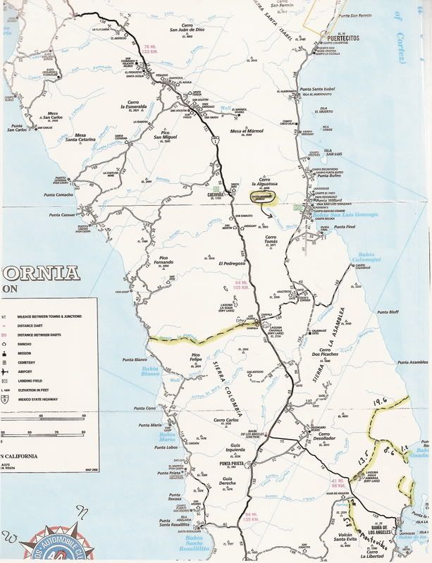
This one had some notes I made of roads that have been around for years (note the ones north of L.A.Bay) and the corrected location of Mision Santa
Maria.
[Edited on 1-26-2009 by David K]
|
|
|
TMW
Select Nomad
Posts: 10659
Registered: 9-1-2003
Location: Bakersfield, CA
Member Is Offline
|
|
The road south of Chapala from hwy1 into San Antonio is a through road to the coast. It connects to the road going east from whats labeled as the
well. There are a couple of ranchos on the way. Makes for an interesting loop of about 80+ miles using this road and the one at Chapala.
|
|
|
TMW
Select Nomad
Posts: 10659
Registered: 9-1-2003
Location: Bakersfield, CA
Member Is Offline
|
|
On David's map there is a 19.6 mile section at the top of Laguna Agua Amarga (off the hwy to LA Bay). I traced it on earth google and followed the
road to 29-20-20.4x113-45-49.43 @676ft where it got blurry and while I couldn't see the trail it is a wash leading out ot the Sea of Cortez at
29-22-39.20x113-44-35.37. On page 19 of the Almanac it is called Punta Candelero. That looks like a Ken Cooke Jeep run.
|
|
|
Taco de Baja
Super Nomad
Posts: 1913
Registered: 4-14-2004
Location: Behind the Orange Curtain, CA
Member Is Offline
Mood: Dreamin' of Baja
|
|
| Quote: | Originally posted by TW
The road south of Chapala from hwy1 into San Antonio is a through road to the coast. It connects to the road going east from whats labeled as the
well. There are a couple of ranchos on the way. Makes for an interesting loop of about 80+ miles using this road and the one at Chapala.
|
How good is that road through the Sierra Columbia heading west from Rancho San Antonio to Blanca? I was last on it back in the late 1980's with my dad
and mom, and it was so bad we never went back. There is a reason why the map shows the road ending at Antonio  . Very pretty country, but it was a long slow trip. There were some nasty stair climbing sections that were almost
too steep and off camber to get up, plus deep ruts, potholes, boulders, etc., etc., etc. Some of the Jeepers would love it, but a full size
pickup....not.
. Very pretty country, but it was a long slow trip. There were some nasty stair climbing sections that were almost
too steep and off camber to get up, plus deep ruts, potholes, boulders, etc., etc., etc. Some of the Jeepers would love it, but a full size
pickup....not.
Truth generally lies in the coordination of antagonistic opinions
-Herbert Spencer
|
|
|
David K
Honored Nomad
Posts: 65563
Registered: 8-30-2002
Location: San Diego County
Member Is Offline
Mood: Have Baja Fever
|
|
| Quote: | Originally posted by TW
On David's map there is a 19.6 mile section at the top of Laguna Agua Amarga (off the hwy to LA Bay). I traced it on earth google and followed the
road to 29-20-20.4x113-45-49.43 @676ft where it got blurry and while I couldn't see the trail it is a wash leading out ot the Sea of Cortez at
29-22-39.20x113-44-35.37. On page 19 of the Almanac it is called Punta Candelero. That looks like a Ken Cooke Jeep run. |
I have mileages on those roads north of L.A. Bay because I drove them about 6 years ago... no 4WD was needed... really surprised at the nice condition
and beautiful canyon scenery up to Candeleros... I have GPS waypoints of those roads in my GPS web page at VivaBaja.com
|
|
|
| Pages:
1
2 |


