| Pages:
1
2
3 |
Steve&Debby
Nomad

Posts: 335
Registered: 12-18-2007
Location: Colusa,California/ Percebu
Member Is Offline
|
|
Santa Maria
I was reading David K and Ken's trip reports on Santa Maria. I am very interested in doing that trip,but I have some questions for both of them.
The ranch stopped putting the road in about a mile past the mission,if I read Davids report correctly.Looking at the map David has on his report it
looks as though it is only a couple of miles to highway 5.It also looks like there is an arroyo or road that goes on to highway 5.
Question is why not continue on down the arroyo to highway 5 ?
With a properly equipped vehicle and carefull driveing.picking your way around the vegetation as to not destroy the land I bet it could be done.
Ken your Rubicon could probably do it.
I have a friend with a 1958 Chevy pickup and I have a pretty radical CJ 7 we go through the Rubicon and Four Dice trails regularly.
How about it Ken? and any one else with a properly equipped vehicle
When would be the best time of year to make this run?
Go down highway 1 to Santa Inez then across to Santa Maria then make our way across to highway 5 and to Gonzaga then to San Flippy then head home. Of
course alot of beer and fish tacos in between 
|
|
|
David K
Honored Nomad
Posts: 65590
Registered: 8-30-2002
Location: San Diego County
Member Is Offline
Mood: Have Baja Fever
|
|
I love it! Mision Santa Maria to Gonzaga Bay!
To drive across Baja there has been a dream for years!
The short answer is that it is a steep sided canyon with waterfall drops and giant boulders... it is almost impossible to go down the canyon on foot!
The Jesuits who founded the mission at Santa Maria in 1767 had gone up the canyon, they named 'El Cajon', as it was like a box canyon... the trail
they used was likely first built by the native Indians. It is visible today and used by hikers. Pack animals had a terrible time... constantly
falling. The Jesuits were removed from the New World before they had a chance to build a better road.
The Franciscans in 1769 built a new section of El Camino Real north of, and out of the canyon just to get pack animals through. Graham Mackintosh
tried to get his burro 'Mision' out to Gonzaga on it, but it was too trecherous and Mision fell... Graham abandoned the burro attempt.
It was the hope of the owner of Rancho Santa Ynez (Josefina Zuñiga) to have a road between her ranch and her Punta Final property... Fred Hampe built
it in the 1960's to the edge of the canyon, 2 miles east of the mission. There was no where to go from there without major construction. At the end of
the road building attempt are petroglyphs on some rocks and the Indian trail goes from there down into the deep canyon. The Camino Real climbs up the
hillside from the road about 1/2 mile from the end, heading north to the top of the canyon rim then east to the desert floor. Only the best trials
style dirt bike rider sould consider riding on it and then only knowing damage and injury will occur. It was rumored Malcolm Smith rode it... I do
know Kevin Ward ('Slider') has... once!
When the Transpeninsular Highway was built near Rancho Santa Ynez, Josefina had lobbied for a cross connector highway to do what her partner Fred
wasn't able... Apparently the Mexican highway engineers took a look at the terrain between Santa Ynez and Gonzaga Bay and promptly decided on going
across further south from Laguna Chapala, where a poor Jeep trail was built by Arturo Grosso in the mid 1950's... to Gonzaga and all the way north to
San Felipe.
Use Google Earth to see the canyon in 3-D... and you will see that any vehicle would not get through, unless it could fly.
Here are some photos... in the next post...
|
|
|
David K
Honored Nomad
Posts: 65590
Registered: 8-30-2002
Location: San Diego County
Member Is Offline
Mood: Have Baja Fever
|
|
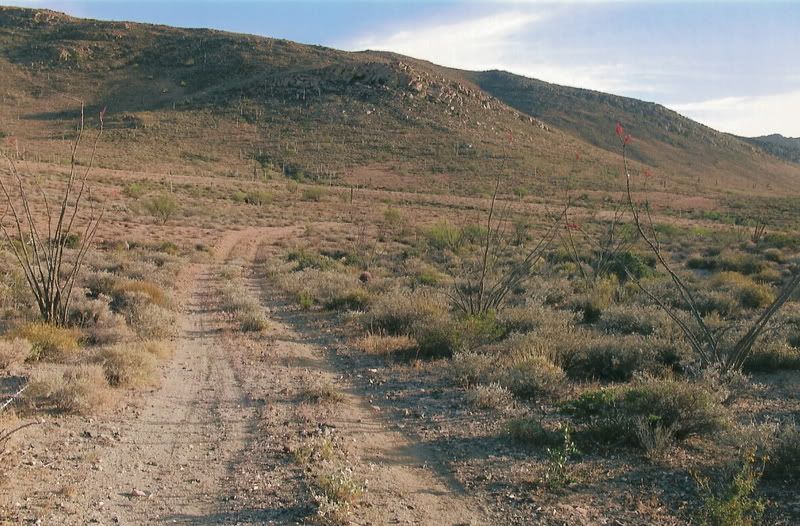
The arroyo about 3/4 mile from the mission, looking down from where the road is... that nice sand doesn't last...
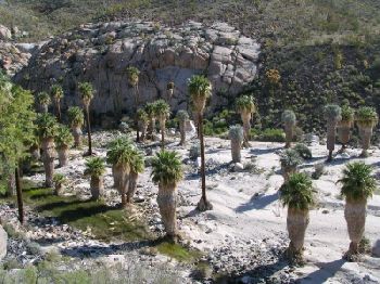
The road drops down into the sand, steeply 1.0 miles from the mission. Here is a photo of me climbing back up this steep drop:
If you pass the road (1.3 miles from the mission) that heads up to the bulldozed grade/ canyon edge... it looks like this:
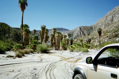
In the arroyo, 1.6 miles eastward from the mission... this is as far as a 4WD can go. Get out and walk past the boulders and you will come to a steep
'waterfall' drop off into the lower Santa Maria Canyon:
At the end of the bulldozed grade/ end of Fred Hampe's road at the edge of the canyon are some petroglyps:

I took this from Doug Bowles plane... it shows the bulldozed grade climbing to the top edge of the canyon and then the Indian trail dropping down from
there to the canyon bottom. Just to the right is where the arroyo makes the big drop into the lower canyon...

Here is a photo of the Camino Real, just above the road... looking down to the arroyo...

|
|
|
David K
Honored Nomad
Posts: 65590
Registered: 8-30-2002
Location: San Diego County
Member Is Offline
Mood: Have Baja Fever
|
|
The Gonzaga Bay side
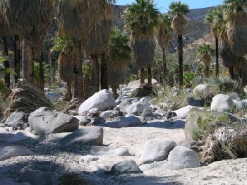
It was here in 1999, that we could not get any further up the canyon on our quads, as brush and boulders block the way. I am pointing to Baja Mur
where the mission is!
In about 1/2 mile was surface water and pools deep enough for a swim!

Aerial photo showing the mouth of the canyon and the arroyo all the way to Punta Final (Gonzaga Bay)... the bottom left of the photo is where the
above photo was taken. The Camino Real leaves the arroyo and climbs up the north side hills, left side of photo, before the canyon begins.

Here is where we took a swim, a half mile up the canyon... the Camino Real is along those hills and ridges, above the canyon.

EL CAMINO REAL
In Nov. 2003, my son and I hiked towards the mission... Soon after climbing out of the Arroyo Santa Maria is this sign!

Here is the Camino Real (all rocks) climbing up... see Arroyo Santa Maria in the background:

You can barely make out the Camino Real on the left side of that slope... In the background is the deep Santa Maria Canyon...

My son pointing the way to the mission! All rocks... we ran short of daylight and turned back after so we wouldn't be hiking at night... We got 2/3 to
3/4 of the way to the mission.

Baja Nomad 'Don Jorge' did the hike a week or so after we did, and made it to the mission and returned via the canyon... which required some deep
water fording.
|
|
|
David K
Honored Nomad
Posts: 65590
Registered: 8-30-2002
Location: San Diego County
Member Is Offline
Mood: Have Baja Fever
|
|
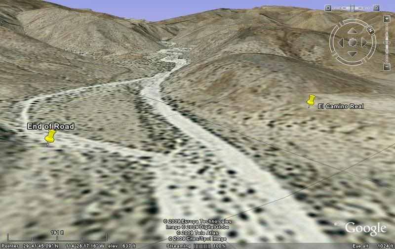
To get to the Camino Real from Gonzaga Bay:
GPS Directions (map datum NAD27 Mexico)
Take Hwy. 5 south 7.4 miles from Rancho Grande, turn west: 29°41.094'/ 114°24.566'
3.2 miles west of Hwy. 5, go straight where most traffic curves left for Las Palmitas: 29°41.278'/ 114°27.639'
0.8 miles from above, park at huge boulder: 29°41.68'/ 114°28.20' (marked as 'End of Road' on Google Earth image in next reply)
Hike to north bank of Arroyo Santa Maria to: 29°41.733'/ 114°28.175' elev. 609' (ECR-1)
Go northwest and climb out of valley, note ocotillos. (Marked as 'El Camino Real' in Google Earth image in next reply)
Along left side of side valley: 29°42.374'/ 114°28.566' elev. 741' (ECR-2)
On first padre built switchback up: 29°42.669'/ 114°28.937' elev. 906' (ECR-3)
On a ridge, trail continues northwest: 29°42.671'/ 114°29.425' elev. 1308' (ECR-4)
On the Camino Real: 29°42.748'/ 114°29.482' elev. 1391' (ECR-5)
Crossing ridges and little mesas: 29°43.008'/ 114°29.967' elev. 1477' (ECR-6)
Drop along side of ridge, trail narrow: 29°43.074'/ 114°30.128' elev.1610' (ECR-7)
End of today's hike just beyond this last clear sign of the old trail: 29°43.141'/ 114°30.189' elev. 1702' (ECR-8)
Junction of ECR & bulldozed road: 29°43.126'/ 114°31.753' elev.1413'
(End of bulldozed road, on canyon ridge: 29°43.033'/ 114°31.556' elev. 1,615' )
Mision Santa Maria: 29°43.891'/ 114°32.794' elev.1628'
[Edited on 1-24-2009 by David K]
|
|
|
David K
Honored Nomad
Posts: 65590
Registered: 8-30-2002
Location: San Diego County
Member Is Offline
Mood: Have Baja Fever
|
|
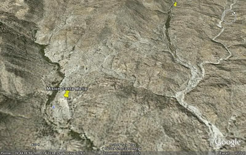
Google Earth lets you see how rugged the terrain is!
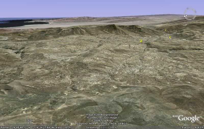
From the Gonzaga Bay side, looking west at the canyon...
--------------------------------------------------------------------------------------
About where the water pools begin if hiking up the arroyo, from Gonzaga.
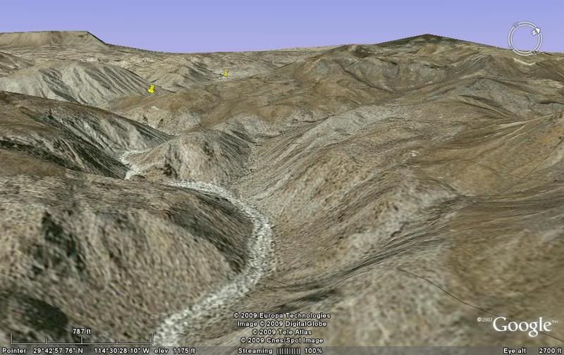
------------------------------------------------------------------------------------------
About halfway up the canyon to the mission valley. The Camino Real is on the ridge tops to the right of the canyon.
--------------------------------------------------------------------------------------
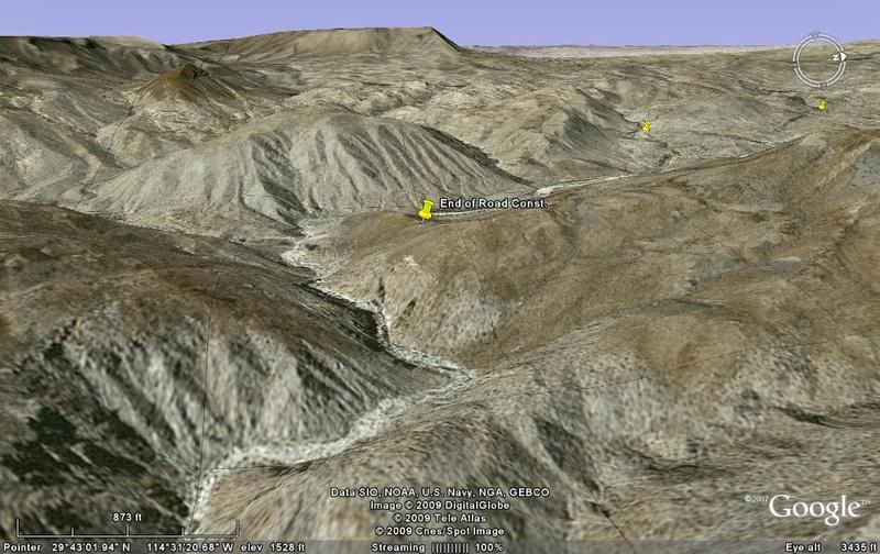
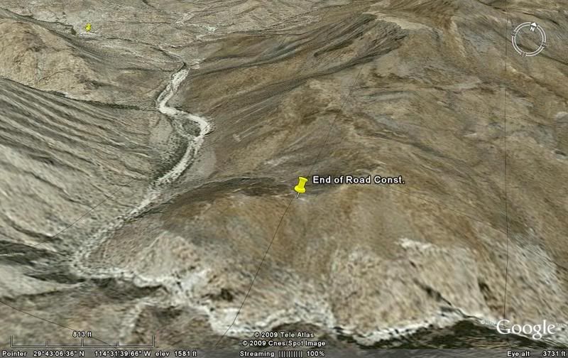
Near the end of the canyon where the mission valley begins, the end of the bulldozed road is marked. The Indian trail is seen dropping down into the
canyon.
------------------------------------------------------------------------------------------
Looking east, towards Gonzaga, down the canyon...
-----------------------------------------------------------------------------------------
Mision Santa Maria... and just over a mile in the distance is the 'Widowmaker' grade heading towards Rancho Santa Ynez.
----------------------------------------------------------------------------------------
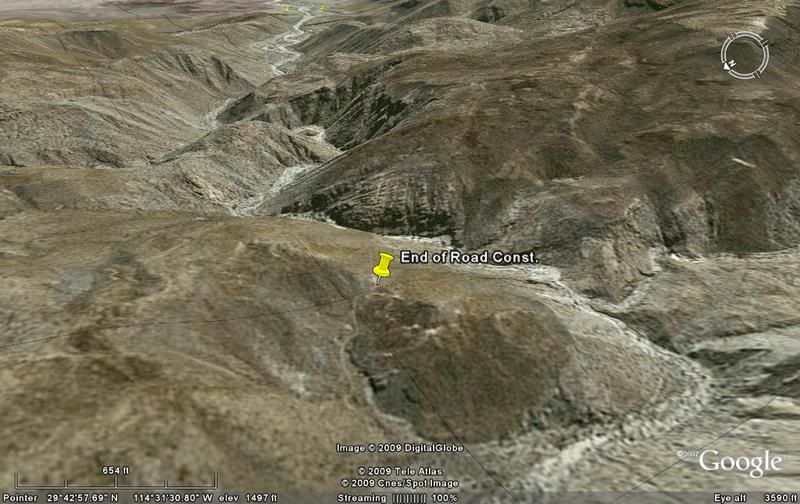
Here is looking towards the mission (4 1/2 miles) from the highpoint (peninsular divide) on the road from Santa Ynez (10 miles away). Punta Final is
in the distance and can be seen from the peninsular divide, on the road.
The three closest yellow markers are 1) The Widowmaker grade, 2) The mission, and 3) the end of road construction, 2 miles past the mission.
[Edited on 1-24-2009 by David K]
|
|
|
Steve&Debby
Nomad
Posts: 335
Registered: 12-18-2007
Location: Colusa,California/ Percebu
Member Is Offline
|
|
David,
My son turns 21 this year and I was trying to think of something to do for his birthday that he would remember all his life. The Santa Maria trip
sounds like a trip that he would like.In looking at all the pictures you have posted and the information you have given it looks to be quite a
challenge. But some more questions;
1 The Camino Real is this an old road and does it go from Gonzaga to Santa Maria?
2 The Jeep trail built in the mid 1950's.Does it continue from Santa Maria to Gonzaga?
3 What about going around the waterfall and working your way down the arroyo ?
4 Where is Laguna Chapala ? Is it where the jeep trail starts?
Thanks for all the information.
|
|
|
David K
Honored Nomad
Posts: 65590
Registered: 8-30-2002
Location: San Diego County
Member Is Offline
Mood: Have Baja Fever
|
|
Steve or Debbie?,
please re-read what I posted above... as all the answers are there.
I show where the Camino Real climbs up the hill from Arroyo Santa Maria (on the Gonzaga Bay side of the mountain)...
I show photos of the 'trail' and it is all rocks, this is the mission train, not the Jeep road of the 50's...
I told you that Nomad 'Don Jorge' came down via the waterfall canyon route and had to get into the water....
Laguna Chapala is on Hwy. 1 and is where the 1950's Jeep trail was built north to Gonzaga and San Felipe... the part north from Gonzaga was improved
about 1960-63, and again with a new graded road in 1986, from Chapala.
A trip to Mision Santa Maria from Santa Ynez is a GREAT adventure... See http://vivabaja.com/msm (our 2007 trip and bighorn encounter). The map on the last page shows the canyon and the Camino Real location as well as
the 'Jeep' roads on both ends of the canyon.
I am happy to help!
|
|
|
Ken Cooke
Elite Nomad
Posts: 8971
Registered: 2-9-2004
Location: Riverside, CA
Member Is Offline
Mood: Pole Line Road postponed due to injury
|
|
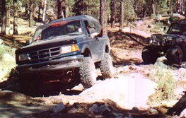
Checking in...
If you have a well set-up CJ-7, the end of our route will be beyond the traditional "end of the road" to the granite pools. You honestly cannot
travel past this point without causing serious damage to your vehicle as the canyon closes up, and the technical level increases dramatically.
At this point (traveling East), you will have to simply hike the remainder of the route as David mentions until you descend in elevation towards
Gonzaga Bay.
In November '09, Baja Grande will continue east as far as our vehicles can travel without damage to the vehicles or the terrain. Tomer has run the
Rubicon, I have run every trail in Big Bear, along with the Hardcore trails in Tecate which are much more challenging than the drive in to Mission
Santa Maria. David K's pickup can easily make it in and out of Mision Santa Maria, as will an open differentialed Cherokee on 31s. It is not
hardcore in any way. The only challenges relate to getting stuck in the swamp on your way into the Mission, or traveling out of the mission as I did
this past November.
Do your best to join our group. We plan to be roughly 15 vehicles strong in November '09. Northern California Toyota Club "Getting Off" plans to
make this their Thanksgiving week trek as to honor their member Andrew Simpkins who encouraged me to continue this 4WD run. Andrew was an avid Jeeper
that led runs for the Easter Jeep Safari in Moab, Utah, and was a great friend of mine. He dreamt of visiting the "Mission Impossible" trail in to
Mission Santa Maria from Rancho Santa Ines, but 5 months before purchasing his '07 JK Rubicon and joining Baja Grande, he succumbed to Leukemia.
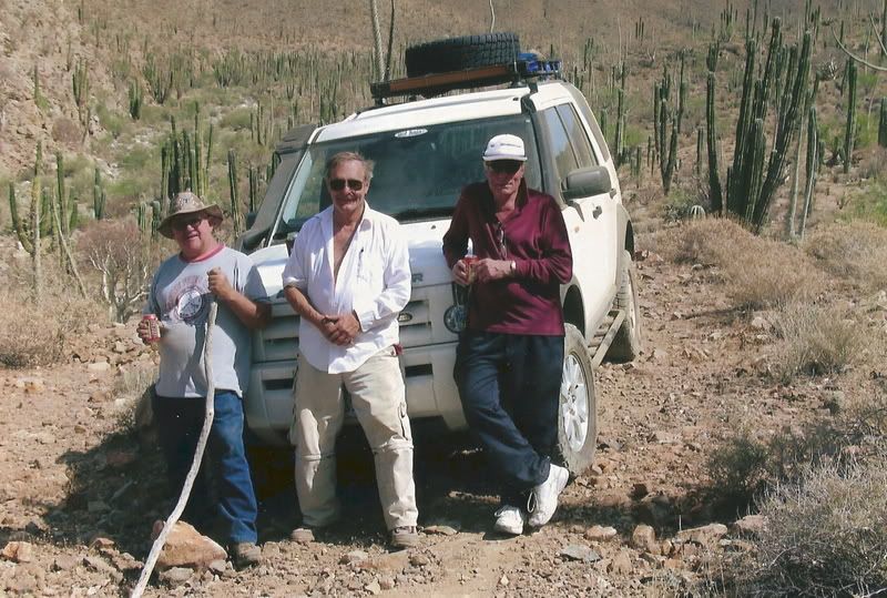
Me and Andrew in 2000 on the Observatory Road, Parque San Pedro Martir, Baja, Mex. (taken from David K's site):
Traveling La Tasajera road, San Pedro Martir, Baja, Mex.

April 2007 -- San Felipe. Andrew's last visit to Baja.
|
|
|
Ken Cooke
Elite Nomad
Posts: 8971
Registered: 2-9-2004
Location: Riverside, CA
Member Is Offline
Mood: Pole Line Road postponed due to injury
|
|
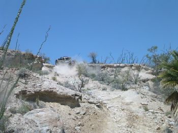
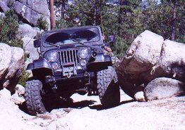
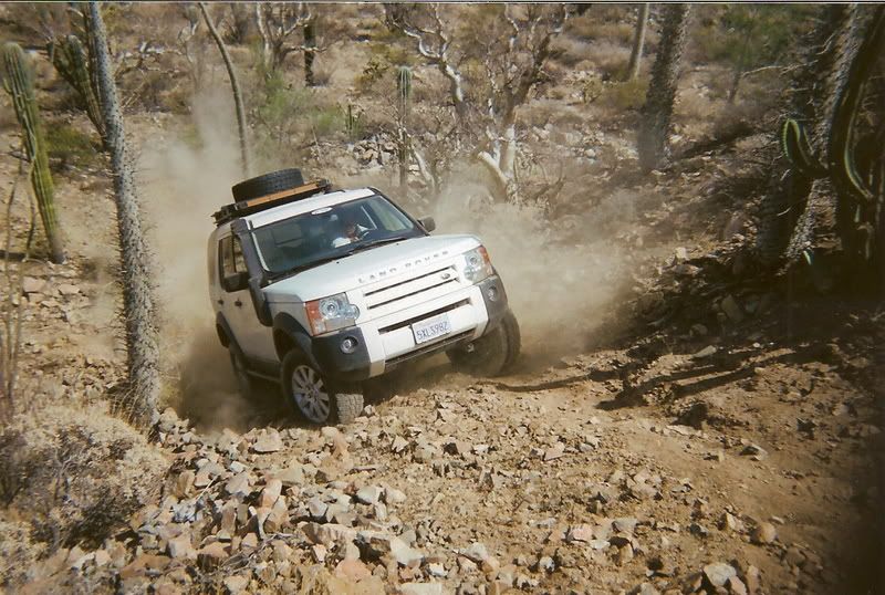
2009 Baja Grande will include a short HARDCORE challenge
Recent photo of me and Jose (BajaCat):

Tomer Avital (Hardcore Jeep Addict) w/gf Iris:


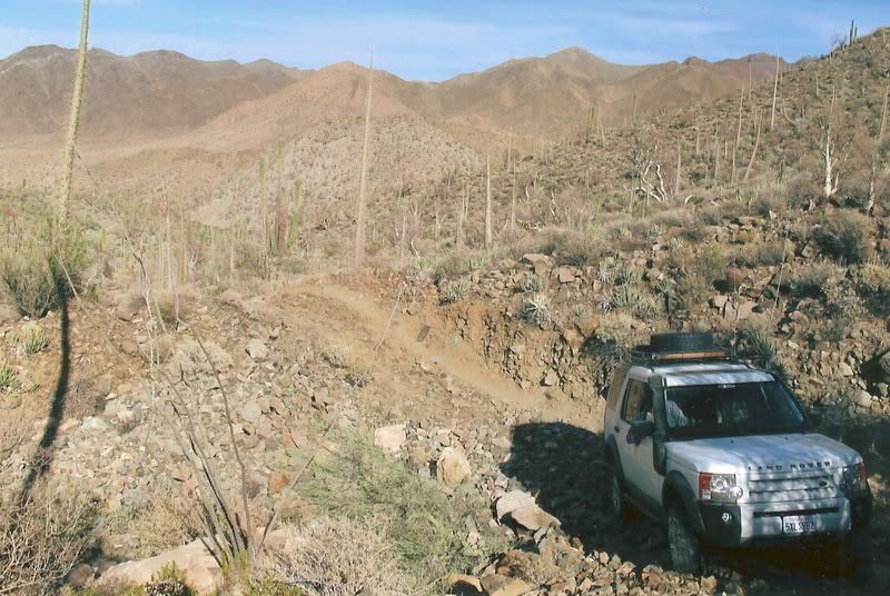
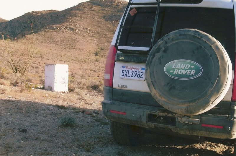
The road past the Mission Sta Maria stops at a row of boulders. Tomer had little difficulty traveling past these boulders and down into the dry
streambed.


The trail actually opens up just past this row of boulders, but returning to the main road presents a problem for vehicles that do not have clearance
and locked differentials fore and aft:


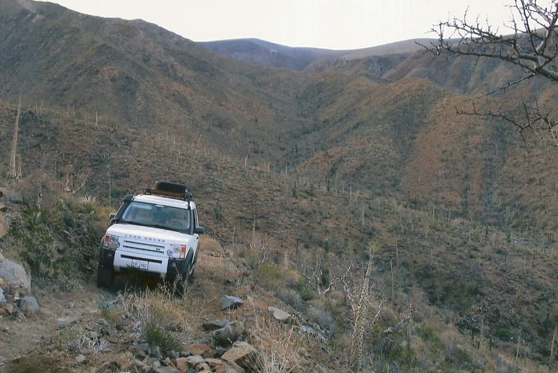
We plan to run past the granite pools until the trail begins to close up in the canyon traveling East. There, we will swim in the granite pools and
hike a little. Exiting will be difficult, but not impossble as shown here:

Traveling West towards the Mission. Obstacles like these make you glad your vehicle has a short wheelbase and/or locking differentials:

|
|
|
Ken Cooke
Elite Nomad
Posts: 8971
Registered: 2-9-2004
Location: Riverside, CA
Member Is Offline
Mood: Pole Line Road postponed due to injury
|
|
| Quote: | Originally posted by Steve& ebby ebby
With a properly equipped vehicle and carefull driveing.picking your way around the vegetation as to not destroy the land I bet it could be done.
Ken your Rubicon could probably do it.
I have a friend with a 1958 Chevy pickup and I have a pretty radical CJ 7 we go through the Rubicon and Four Dice trails regularly.
How about it Ken? and any one else with a properly equipped vehicle
When would be the best time of year to make this run? |
 No damage will be done to the land. Rocks may get slid around on top of
each other, but we will keep overall impact to an absolute minimum (Tread Lightly). No damage will be done to the land. Rocks may get slid around on top of
each other, but we will keep overall impact to an absolute minimum (Tread Lightly).
My Rubicon won't have many difficulties. I only run 33" tires. I have
Warn skidplates under the Rubicon, Fabtech rocker guards, and FourXDoctor Differential guards, keeping the Rubicon in tip top shape for a daytime run
past the Mission.
Ralph Shoemaker is our resource in case vehicles break on the trail.

He lives in Rancho Santa Ines part time. His wife told us that in April each year, "The Snakes Come Out." This is a great time when not to be in the
region. This is also when the temperatures skyrocket. Best to run these trails from October through March, no later.
There will be Toyota's joining Baja Grande in November '09. We estimate this will be a good year for Baja Grande despite the economic slump we're in
(recovery in '10?).
Gettin' Off 4WD Club of San Jose, CA:


Let me know how this sounds, Steve & Debbie. 
|
|
|
Steve&Debby
Nomad
Posts: 335
Registered: 12-18-2007
Location: Colusa,California/ Percebu
Member Is Offline
|
|
Hi Ken,
The trip sounds great to me.Do you have exact dates lined out for the trip? Also a route we would be takeing? It sounds like you are game for trying
to make it to highway 5. My CJ7 is set up as follows; tuned port injection 350 chevrolet engine,TH700r automatic transmission,fullwidth dana60 front
and rear,welded rear end,detroit locker front,5:38 gears,spring over,high steering,38x15.50Rx15 TSL Interco tires, onboard air system,on board
welder,warn 9000lb winch 25 gallon gas tank,2 5 gallon gas cans.
Running through the big rocks we always have a spotter to guide you over or around the boulders. From looking at the pictures it does not look that
bad,especially since I know that a stock toyota and a stock range rover made it in and out. You say the canyon gets very narrow and steep,could we
work our way around the canyon? Then go down in the arroyo toward highway 5.
Sorry to hear about your friend,Sounds like he was a great guy.
|
|
|
Ken Cooke
Elite Nomad
Posts: 8971
Registered: 2-9-2004
Location: Riverside, CA
Member Is Offline
Mood: Pole Line Road postponed due to injury
|
|
Steve,
You can't get to Hwy 5. Its not doable. We won't even try it.
Our plan is to camp near the Mission, and play on the rocks while we are there.
This is a camping trip where we camp in San Felipe, Gonzaga, LA Bay, and at the Mission during Thanksgiving week '09. You might be more interested in
driving to the Mission and playing on the trail and beyond the Mission itself. But, having a group on hand is always better if a vehicle breaks down.
Your Jeep sounds very capable, though.
This trip will tentatively happen Nov. 21-28th, 2009.
|
|
|
David K
Honored Nomad
Posts: 65590
Registered: 8-30-2002
Location: San Diego County
Member Is Offline
Mood: Have Baja Fever
|
|
"You say the canyon gets very narrow and steep,could we work our way around the canyon? Then go down in the arroyo toward highway 5."
Didn't I already cover this?
Steve or Debbie, we are hardcore off road travelers and we really want to get across the peninsula in this area... there is just no path available
other than by foot ... as I showed you, above.
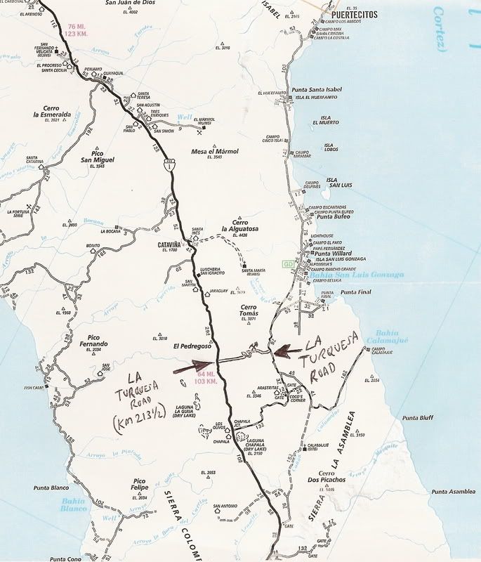
Roy and his LR-3 did get through La Turquesa Canyon and went from Mex. 5 to Mex. 1 with the help of TW... this is halfway to Chapala, from Santa Ynez/
Cataviña.
|
|
|
David K
Honored Nomad
Posts: 65590
Registered: 8-30-2002
Location: San Diego County
Member Is Offline
Mood: Have Baja Fever
|
|
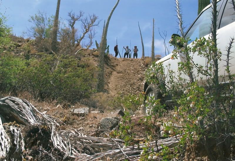
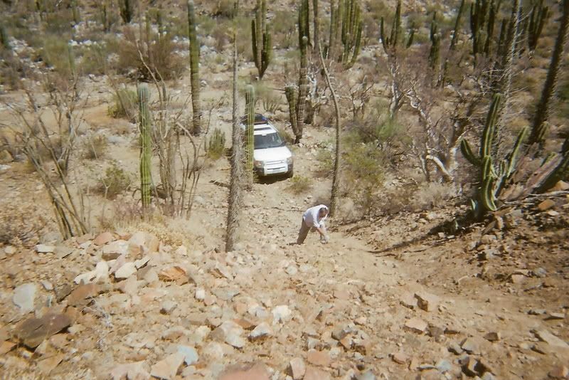
The Squarecircle's (Roy's) Land Rover isn't exactly stock... He has done a lot with it and uses the biggest tires that will fit.
Anyway, after Baja Angel and I checked out the La Turquesa Grade (from the Highway One side) and reported here on Nomad (Feb. 2007) see http://vivabaja.com/20t , Roy made several research trips... Ken Cooke also tried to get his Jeep friends through... too tough.
Roy did make it, with help from TW... the hard way, going uphill from Hwy. 5 to Hwy. 1. Here are some photos of that historic event.
Getting across the desert floor from the turquoise mine to the bottom of the grade was a big task... then the steep, abandoned grade up was next!
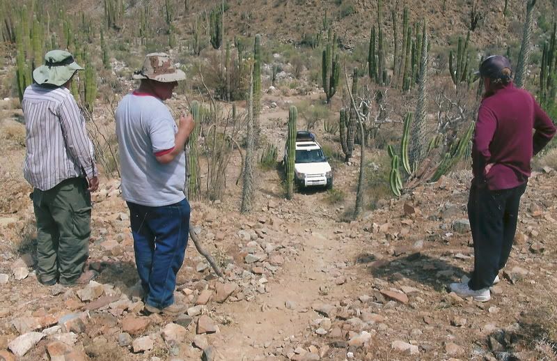
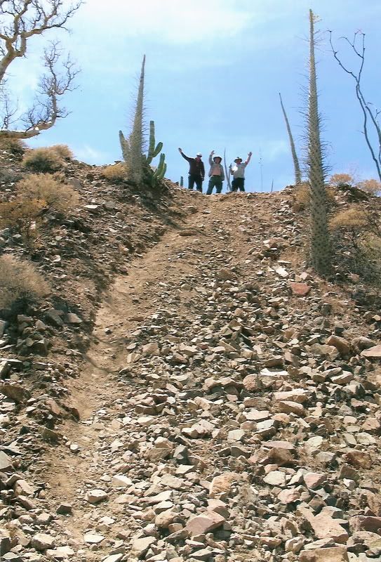

The Top!
Out to Highway 1...
[Edited on 1-25-2009 by David K]
|
|
|
TMW
Select Nomad
Posts: 10659
Registered: 9-1-2003
Location: Bakersfield, CA
Member Is Offline
|
|
In David's photos as you look up the hill the MC trail is on the left and had good traction but the right side was a lot of loose rock. That had us
worried that the sqcircle might slide off onto and down it with bad consequences. But with great driving skills he got up to the cheers of all these
60+ year old kids.
|
|
|
Steve&Debby
Nomad
Posts: 335
Registered: 12-18-2007
Location: Colusa,California/ Percebu
Member Is Offline
|
|
So ,your saying theres a chance "A"
|
|
|
David K
Honored Nomad
Posts: 65590
Registered: 8-30-2002
Location: San Diego County
Member Is Offline
Mood: Have Baja Fever
|
|
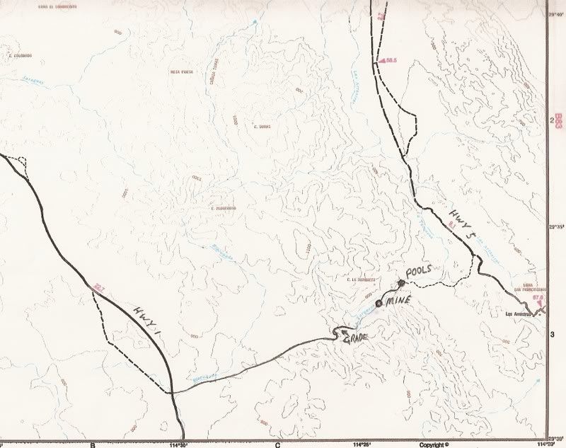
Here's where the La Turquesa Canyon shortcut is... the route that Roy in his LR-3 got through.
[Edited on 1-27-2009 by David K]
|
|
|
TMW
Select Nomad
Posts: 10659
Registered: 9-1-2003
Location: Bakersfield, CA
Member Is Offline
|
|
If your going to try this route I suggest a short wheel base vehicle like a Jeep or Xterra or 4runner, the smaller the better. ATV no problem,
especially if 4x4. There are two places where you will be working around large rocks in a sand wash setting. I also highly recommend a locking rear
axle and 4 wheel drive. Someone said that a full size truck had gone thru before. Either he found a different route or the rains have changed the
course since then. The day before the run we walked all the way from the mine to the hill out of the wash (about 3 miles) with a master trail finder
(Richard, friend of Sqcircle). We marked and took the best trail we could find. Roy's Land Rover has several 4x4 controls but did not have a true
locking rear axle. It had an auto type mode that would brake the spinning wheel, great for snow and ice but not for rocks and sand.
|
|
|
David K
Honored Nomad
Posts: 65590
Registered: 8-30-2002
Location: San Diego County
Member Is Offline
Mood: Have Baja Fever
|
|
TW, how did you mak the route between the mine and the bottom of the grade? Did you need to wiggle around many plants, or just boulders. If someone
drove down the grade to the desert floor, is the route to the mine an obvious choise... straight ahead or follow the wash?
|
|
|
| Pages:
1
2
3 |


