| Pages:
1
2 |
flyfishinPam
Super Nomad
   
Posts: 1727
Registered: 8-20-2003
Location: Loreto, BCS
Member Is Offline
Mood: gone fishin'
|
|
San Javier
I've been giving tours to passengers on the Cruise West ship that comes weekly from Cabo San Lucas. Here are some photos of my favorite tour, this
time taken just alone with my children:
About halfway up the road to San Javier is the stop at Cuevas Pintas (cave paintings) the pools behind the cave paintings are, to me more of an
attraction than the paintings themselves. This is just a few dozen yards from the cave paintings wall on a good trail:

At Rancho Viejo, the ranch that makes my favorite goat cheese- there are various farm animals that my kids love to visit. Pigs, goats, bulls, horses
and donkeys and this pair of turkeys that are always seen hanging around:

On the ranch property and across the road and down the hill from the site of ruins of the original San Javier chapel, priest's house and salitta, is
where the dam was built (originally by the jesuits) to contain the flowing stream. It has been maintained by the family at Rancho Viejo and the ranch
has been family owned for over 150 years:

This is the west entrance of the mission at San Javier as the sun's light is striking on it:

This is the generator that powers the little town at nightfall. Its right across the street from the police station on the main boulevard:

And this is the west side of El Pilon de Las Parras, 2,500 feet high at the top of which can be seen the Sea of Cortez, Magdelena Bay and the Pacific
Ocean. I am planning to climb it this spring on a clear day:

I am hoping to find a good access to the old jesuit road so that I can ride my mountain bike up it. I'm afraid to use the main road as the vehicles
drive too fast on it.
At this time the road to San Javier is being paved but that is an understatement. It is being rebuilt and they have a long ways to go and a huge job
to do. IMHO the road will lose its character after it is paved so I plan to enjoy it as much as possible while its still mostly a dirt road. Usually
the road is suitable for just about any vehicle but near the road construction part there will often be difficult access and a loose base that
required 4WD last time I visited.
|
|
|
Bob H
Elite Nomad
     
Posts: 5867
Registered: 8-19-2003
Location: San Diego
Member Is Offline
|
|
Wow, Pam... very nice photos and what a beautiful area.
Bob H
|
|
|
shari
Select Nomad
      
Posts: 13052
Registered: 3-10-2006
Location: bahia asuncion, baja sur
Member Is Offline
Mood: there is no reality except the one contained within us "Herman Hesse"
|
|
Pam...do you do private tours there? What would it cost for a family...do you have a vehicle to take them? Love the photos amiga.
|
|
|
Santiago
Ultra Nomad
    
Posts: 3539
Registered: 8-27-2003
Member Is Offline
|
|
Thanks Pam - brings back memories of 10 years ago when I rented a jeep in town and drove this road to Mag Bay. The stream is by far the best place -
stopped there and ate my burritos from Cafe Sol. Saw little fish I swore were trout fry - must of been mistaken - no?
Does essence predate existence?
|
|
|
David K
Honored Nomad
        
Posts: 65364
Registered: 8-30-2002
Location: San Diego County
Member Is Offline
Mood: Have Baja Fever
|
|
San Javier is the finest, original Jesuit stone mission example in Baja... IMO.
A visit to it is a must!
Here is a photo on the roof from our second trip there, in 1976...

|
|
|
David K
Honored Nomad
        
Posts: 65364
Registered: 8-30-2002
Location: San Diego County
Member Is Offline
Mood: Have Baja Fever
|
|
another...

|
|
|
flyfishinPam
Super Nomad
   
Posts: 1727
Registered: 8-20-2003
Location: Loreto, BCS
Member Is Offline
Mood: gone fishin'
|
|
We some little minnows in pools of the streams sometimes but don't know what they are but that's likely due to the fact that wouldn't take my smallest
fly a size 4. I don't think I'd feel them even on my lightest rod a 5 WT.
Cruise West hires the ground service (C&C) that I also use for airport transfers for our fishermen. She needed guides and this is our low season
so I figured why not? Its fun and I can apply my plant physiology degree during the tour when I discuss the flora of the area. Also coupled with the
great stories on the history of the settlement here its an enjoyable tour.
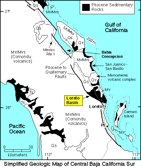
I could use some reference on the geology as I don't have much info and it is so striking. Could anyone point me out to online references? Loreto is
a small town and no books here available at this time also amazon takes 30 days to deliver to here.
|
|
|
flyfishinPam
Super Nomad
   
Posts: 1727
Registered: 8-20-2003
Location: Loreto, BCS
Member Is Offline
Mood: gone fishin'
|
|
WOW! David you got permission to go on top of the roof! I'll need to look into that as well, or did you scale the walls using those uneven stones
that we're told was used as a permanent scaffolding during the construction? We're also told that the roof is designed to channel rainwater to fall
onto the west side of the building and into the old fountain on the west side? Could you see that kiind of thing on the roof?
|
|
|
David K
Honored Nomad
        
Posts: 65364
Registered: 8-30-2002
Location: San Diego County
Member Is Offline
Mood: Have Baja Fever
|
|
| Quote: | Originally posted by flyfishinPam
WOW! David you got permission to go on top of the roof! I'll need to look into that as well, or did you scale the walls using those uneven stones
that we're told was used as a permanent scaffolding during the construction? We're also told that the roof is designed to channel rainwater to fall
onto the west side of the building and into the old fountain on the west side? Could you see that kiind of thing on the roof?
|
We were invited up...
My girlfriend, my mother and I arrived (my dad went fishing that day) in my Jeep and a little old man came over to us, he unlocked the door to the
stairway... and we went up!
|
|
|
David K
Honored Nomad
        
Posts: 65364
Registered: 8-30-2002
Location: San Diego County
Member Is Offline
Mood: Have Baja Fever
|
|
| Quote: | Originally posted by flyfishinPam
I could use some reference on the geology as I don't have much info and it is so striking. Could anyone point me out to online references? Loreto is
a small town and no books here available at this time also amazon takes 30 days to deliver to here. |
Here's some:
Upper Oligocene to Middle Miocene volcanic and sedimentary rocks in the Loreto region, Baja California Sur, are widely exposed and make up the Comondú
Group as redefined here following McFall. The Comondú Group is part of a volcanic arc and forearc basin that formed along the northwestern margin of
Mexico. Regional to detailed scale mapping, stratigraphic analysis, and geochronology in a 10–20-km-wide and 70-km-long belt from the gulf escarpment
to the coast near Loreto reveal three main units in the Comondú Group and a composite thickness of 1.5–2 km. (1) The lower clastic unit (30–19 Ma)
contains 200–300 m of fluvial sandstone and conglomerate with probable local eolian deposits and numerous felsic tuffs and basalt flows that
accumulated in a forearc basin. (2) The middle breccia and lava flow unit (19–15 Ma) is up to 750 m thick and consists of massive andesite breccia
that was deposited as proximal debris flows interbedded with minor andesite lava flows. (3) The upper lava flow and breccia unit (15–12 Ma) consists
almost entirely of up to 600 meters of andesite lava flows a few kilometers west of Loreto that are part of a composite volcano. North and south of
Loreto for up to 25 km, the unit is composed of andesite lava flows and massive andesite breccia that formed from thick debris flows near that and
other volcanic centers. The three units of the Comondú Group in the Loreto area correlated with the Salto, Pelones, and Ricasón formations of the
Bahía Concepción area. The lower clastic unit of this study is time equivalent to the marine San Gregorio, El Cien, and Isidro formations on the
western and southern Baja California peninsula. The middle and upper units of the Loreto area are the proximal equivalent to the type section of the
Comondú Group near the village of Comondú. During deposition of the lower part of the Comondú Group, the arc lay to the east on mainland Mexico in the
Sierra Madre Occidental, and then migrated to the position of the Gulf of California at about 25 Ma. At 19 Ma the proximal part of the arc migrated
abruptly >50 km westward to approximately the position of Carmen Island and at 15 Ma the arc once again stepped west forming eruptive centers along
the coast near Loreto until 12 Ma. Also at 15 Ma, the proximal forearc region changed from aggradational to neutral or erosional such that no rocks of
the upper unit are preserved in the gulf escarpment.
|
|
|
Bob H
Elite Nomad
     
Posts: 5867
Registered: 8-19-2003
Location: San Diego
Member Is Offline
|
|
David... it seems all of your responses are doubled.
Bob H
|
|
|
David K
Honored Nomad
        
Posts: 65364
Registered: 8-30-2002
Location: San Diego County
Member Is Offline
Mood: Have Baja Fever
|
|
| Quote: | Originally posted by Bob H
David... it seems all of your responses are doubled.
Bob H |
Not on my end Bob... try refreshing the page...
|
|
|
Timo1
Senior Nomad
  
Posts: 760
Registered: 11-2-2007
Location: Homeless
Member Is Offline
Mood: Lovin every minute of it
|
|
I'm getting the same thing David
In all the threads you've responded in
Wierd
|
|
|
David K
Honored Nomad
        
Posts: 65364
Registered: 8-30-2002
Location: San Diego County
Member Is Offline
Mood: Have Baja Fever
|
|
Pam, here is a geology map...

came from this link on the geology of the Loreto basin: http://www.uoregon.edu/~rdorsey/Loreto.html
This was all found by going to the bottom of the Nomad page and using the Google search... 'Loreto geology'
|
|
|
David K
Honored Nomad
        
Posts: 65364
Registered: 8-30-2002
Location: San Diego County
Member Is Offline
Mood: Have Baja Fever
|
|
| Quote: | Originally posted by Timo1
I'm getting the same thing David
In all the threads you've responded in
Wierd |
Well, I am posting the only way I have always done... looks fine on my screen... Doug can see what's up, perhaps... Other than refreshing your browser
and see if the double posts go away... nothing else to do.
|
|
|
Timo1
Senior Nomad
  
Posts: 760
Registered: 11-2-2007
Location: Homeless
Member Is Offline
Mood: Lovin every minute of it
|
|
Not to worry
Its all fixed now....some how
Must have been sun spots
|
|
|
Paulina
Ultra Nomad
    
Posts: 3812
Registered: 8-31-2002
Location: BCN
Member Is Offline
|
|
Pam,
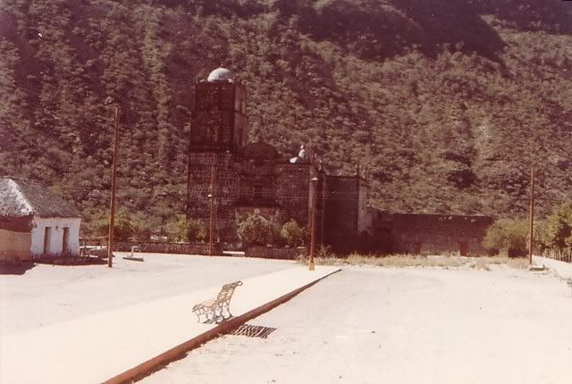
Thank you so much for posting your photos. I have been wondering for a very long time what the town of San Javier looks like now. The last time I was
there was in 1979. I don't remember very much other than it seemed to take forever getting there up a long and winding dirt road. We stopped the jeep
at a place where there were pools of water that we used to rinse the road dirt off of our bodies.
I really want to go back there someday.
Thanks again,
P<*)))>{
View towards the mission in 79:

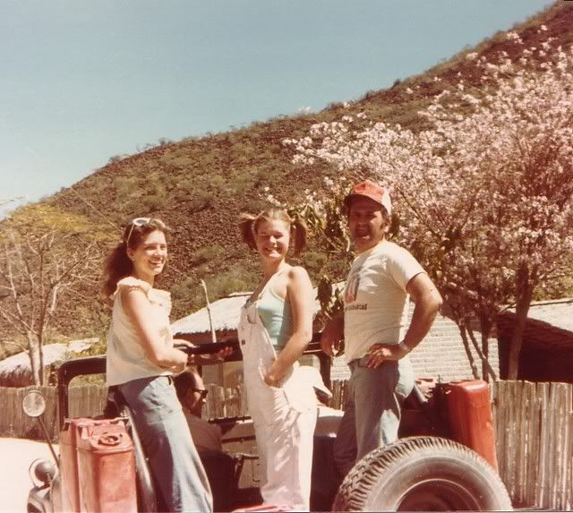
Our transportation. There were six of us riding in that little jeep:

\"Well behaved women rarely make history.\" Laurel Thatcher Ulrich
|
|
|
elgatoloco
Ultra Nomad
    
Posts: 4348
Registered: 11-19-2002
Location: Yes
Member Is Offline
|
|
Paulina - San Javier has not changed much at all and you even less! 
Barb and I drove up there in '96 and then on to Comundu. It was a great all day trip with a new discovery around every corner. We had no idea of the
condition of the road and if we could make it all the way to the other side. The plant life was spectacular as there had been recent rains. Cactus
bulging and ocotillo blooming and big fig trees clinging to rock walls. Have been wanting to get back up there ever since. The first view of San Jose
de Comundu from upon high is unforgettable.
Good for the folks who travel the road reguarly that it is being paved.
Pam thanks for posting photos!
MAGA
marooons Are Governing America
|
|
|
Bob H
Elite Nomad
     
Posts: 5867
Registered: 8-19-2003
Location: San Diego
Member Is Offline
|
|
| Quote: | Originally posted by David K
| Quote: | Originally posted by Bob H
David... it seems all of your responses are doubled.
Bob H |
Not on my end Bob... try refreshing the page... |
Wow, you're right.
Bob H
|
|
|
David K
Honored Nomad
        
Posts: 65364
Registered: 8-30-2002
Location: San Diego County
Member Is Offline
Mood: Have Baja Fever
|
|

|
|
|
| Pages:
1
2 |

