Baja12valve
Nomad

Posts: 185
Registered: 7-12-2006
Location: Oak View
Member Is Offline
|
|
Stone ruins in Bay of LA, above Punta la Gringa
Saw this on my last trip and I cannot find any information about it. It is a stone ruin a few miles North of Punta la Gringa. On my Baja Norte book,
page N-26, it shows a dirt road going North, crossing the El Toro river. There really is not one road, but a series of them pretty much ending at the
river, which was dry. I had to drive upriver, soft deep sand, 4wd a must, to get around the island delta to access the North side to see what was
there, if the road continued. It did not, but there on the hill just above the river were the end walls of this stone house, roof, side walls long
gone. Quite long, not very wide, looks more like a storeroom or warehouse, my guess. The rocks were amazing, all sorts of colors and textures, very
different from what was there locally. I did not have a camera, that won't happen again, to take a picture. Does anybody know of this ruin or its
history? I want to go back to it.
|
|
|
David K
Honored Nomad
Posts: 65596
Registered: 8-30-2002
Location: San Diego County
Member Is Offline
Mood: Have Baja Fever
|
|
Hmmm... the road that goes north from La Gringa along Arroyo El Toro passes access road back east to various coves along the coast, including 'Campo
Colorado' (across from Smith Island (Isla Colorado)... but if you stay in the main road heading north and northwest you will get to the 'El Toro'
copper mine... The ore was shipped out from La Gringa. I have been told of a ghost town at the end of a trail from the copper mine, but did not find
it (hiked with Bedman and other amigos, following Doc's directions).
Is your stone ruin near the coast, within sight of the coast or inland?
The end of the road at the El Toro Copper Mine.
Located about 7 miles northwest of La Gringa (north end of Bahia de los Angeles),
GPS: N29°05.86' W113°35.78' (NAD27 Mexico).
Here, in this trip page is a photo of the copper mine: http://vivabaja.com/402
[Edited on 4-3-2009 by David K]
|
|
|
Baja12valve
Nomad
Posts: 185
Registered: 7-12-2006
Location: Oak View
Member Is Offline
|
|
I only have one map to go by, so hopefully there are not too many differences from what is available to you. I do not have the El Toro copper mine on
mine, but I do have the El Toro river. My map shows a road going due North from La Gringa, crossing the El Toro river in about 3-4 miles, continuing
up to Punta Cardon. In reality, the road ends at the river, or it sure seemed to. When I hit the river there is a large delta full of brush and
debris, about one mile across. I drove in the soft sand upriver until I found a thread of sand and was able to turn back to the ocean, reaching it
eventually. The ruin is on the North side of the river, up on a small hill overlooking the ocean and islands beyond. From the shape of it and what you
say about the mine, it may be related. It is way to long and narrow for a home or church, but could be storage of some kind. From your GPS, it locates
the El Toro mine about 8 miles North and about 5 miles West of La Gringa, but South and West of Isla Alcatraz. Correct?
|
|
|
David K
Honored Nomad
Posts: 65596
Registered: 8-30-2002
Location: San Diego County
Member Is Offline
Mood: Have Baja Fever
|
|
| Quote: | Originally posted by Baja12valve
I only have one map to go by, so hopefully there are not too many differences from what is available to you. I do not have the El Toro copper mine on
mine, but I do have the El Toro river. My map shows a road going due North from La Gringa, crossing the El Toro river in about 3-4 miles, continuing
up to Punta Cardon. In reality, the road ends at the river, or it sure seemed to. When I hit the river there is a large delta full of brush and
debris, about one mile across. I drove in the soft sand upriver until I found a thread of sand and was able to turn back to the ocean, reaching it
eventually. The ruin is on the North side of the river, up on a small hill overlooking the ocean and islands beyond. From the shape of it and what you
say about the mine, it may be related. It is way to long and narrow for a home or church, but could be storage of some kind. From your GPS, it locates
the El Toro mine about 8 miles North and about 5 miles West of La Gringa, but South and West of Isla Alcatraz. Correct? |
Sounds like you have an older Baja Almanac (Norte), which is one of the best maps you can have for exploring... topped only buy the newer 2003 all
color Almanac (also one book for all of Baja)...
The mine is not on any map I have seen... Here is the older Almanac that I used in 2002 to plot the mine and road on (note arrow pointing to it):
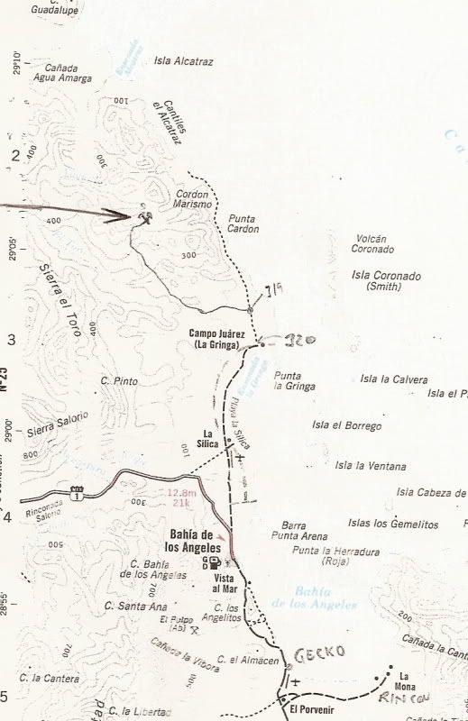
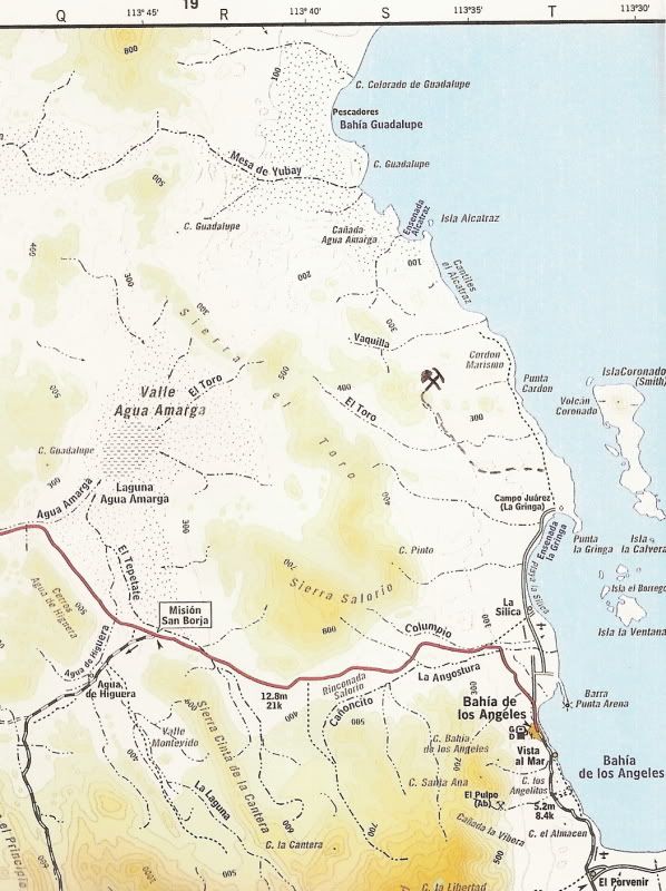
Here is the newer Almanac with mine and road added:
ALSO, of interest perhaps... there is a good road that goes north from the dry lake bed to both Guadalupe (Remedios) Bay and way north to Candeleros
(opposite the north end of Isla Angel de la Guarda)... not on any map... but, I have GPS data for those roads in my web site GPS list.
|
|
|
David K
Honored Nomad
Posts: 65596
Registered: 8-30-2002
Location: San Diego County
Member Is Offline
Mood: Have Baja Fever
|
|
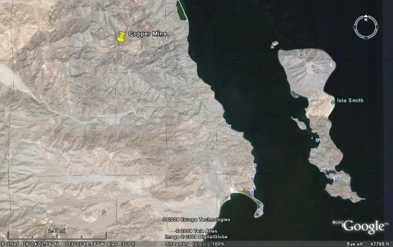
El Toro Copper Mine
Exact location from space:
|
|
|
David K
Honored Nomad
Posts: 65596
Registered: 8-30-2002
Location: San Diego County
Member Is Offline
Mood: Have Baja Fever
|
|
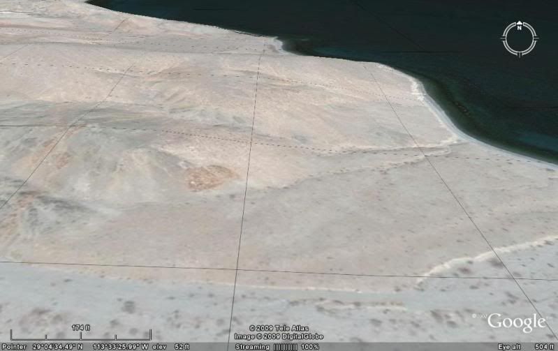
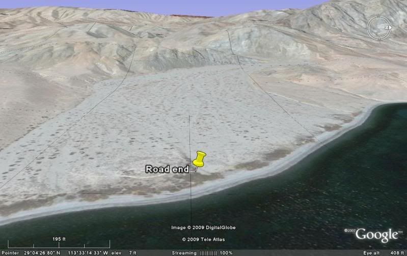
El Toro Delta
| Quote: | Originally posted by Baja12valve
I only have one map to go by, so hopefully there are not too many differences from what is available to you. I do not have the El Toro copper mine on
mine, but I do have the El Toro river. My map shows a road going due North from La Gringa, crossing the El Toro river in about 3-4 miles, continuing
up to Punta Cardon. In reality, the road ends at the river, or it sure seemed to. When I hit the river there is a large delta full of brush and
debris, about one mile across. I drove in the soft sand upriver until I found a thread of sand and was able to turn back to the ocean, reaching it
eventually. The ruin is on the North side of the river, up on a small hill overlooking the ocean and islands beyond. From the shape of it and what you
say about the mine, it may be related. It is way to long and narrow for a home or church, but could be storage of some kind. From your GPS, it locates
the El Toro mine about 8 miles North and about 5 miles West of La Gringa, but South and West of Isla Alcatraz. Correct? |
Here is the Arroyo el Toro 'delta' and yes, you can see the road comes to an end... I put a pin marker there.
I did not see your ruin on the north side, but perhaps you (having been there) can find it on Google Earth... Is it in the area of this image?:
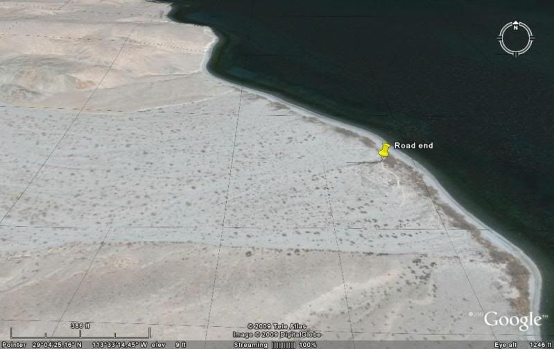
Here's a close up of the north bank of Arroyo el Toro, by-the-sea... Ruins down there?
[Edited on 4-3-2009 by David K]
|
|
|
Baja12valve
Nomad
Posts: 185
Registered: 7-12-2006
Location: Oak View
Member Is Offline
|
|
Boy, I have to hand it to you, NICE job of research. You have the area pegged. I have the older Almanac showing the exact same map as you posted. No
mine. Your newer one is a lot more detailed. Your first picture of Google Earth shows the road going deeper into the delta than I drove. I turned left
the instant I hit the sand to get around the river channels. Your next Google Earth pretty much hits it. Although I am not 100% positive, I remember
the ruins to be on the left side of the picture, where the reddish tone bank meets the riverbed. I had to climb out of the riverbed crawling up a
small but sharp bank. From there I did not drive far. Walking, I did climb some small hills, one of which would be a geologists dream. That is why I
think the ruins are deeper, or a bit up from the ocean, not right on it. They had outstanding view. To be honest, I am not sure you would find them in
Google Earth, they would blend in so well it would be hard to pick out. SO, where and when shall we meet to go there?
|
|
|
David K
Honored Nomad
Posts: 65596
Registered: 8-30-2002
Location: San Diego County
Member Is Offline
Mood: Have Baja Fever
|
|
| Quote: | Originally posted by Baja12valve
Boy, I have to hand it to you, NICE job of research. You have the area pegged. I have the older Almanac showing the exact same map as you posted. No
mine. Your newer one is a lot more detailed. Your first picture of Google Earth shows the road going deeper into the delta than I drove. I turned left
the instant I hit the sand to get around the river channels. Your next Google Earth pretty much hits it. Although I am not 100% positive, I remember
the ruins to be on the left side of the picture, where the reddish tone bank meets the riverbed. I had to climb out of the riverbed crawling up a
small but sharp bank. From there I did not drive far. Walking, I did climb some small hills, one of which would be a geologists dream. That is why I
think the ruins are deeper, or a bit up from the ocean, not right on it. They had outstanding view. To be honest, I am not sure you would find them in
Google Earth, they would blend in so well it would be hard to pick out. SO, where and when shall we meet to go there? |
Iwould love to go exploring old ruins in Baja right now... believe me! Working on the Baja Missions web page revision is keeping me in tune, along
with various other Nomad projects... like yours!
I looked and looked for some sign of a ruin near that tan colored slope, but still nada...
Here is a view looking west at the El Toro arroyo 'delta':
|
|
|
Baja12valve
Nomad
Posts: 185
Registered: 7-12-2006
Location: Oak View
Member Is Offline
|
|
I am starting to feel like the old prospector who has done a real bad job of marking the Lost Dutchman Mine, the only difference is that I am still
alive. I did not really think too much about it when I was there, I just thought it was something pretty cool. In my notes I wrote " we mountain biked
to a small strange rock ruin, collect rocks beyond the ruin". At the time I was more interested in the rocks than the ruin, although I never did
forget about it. I know that we did not ride there, but drove. We did do a number of miles on bikes but we turned around and thought it would be a
good exploration drive the next day, which we did. As I fly Google Earth, it all looks different, maybe it is the view. I cannot get close as my
resolution is bad, it gets way too blurry. With that, Google Earth is not much help. After the trip I marked the location in the Almanac, but that was
only a guess, no GPS, I was assuming I was North of the El Toro river, and I still believe that. From the Google Earth, I feel that I recognize the
shape of the delta as I imagine it would be from my perspective of driving. When I posted my question I really thought that there would be a bunch of
Nomads who would know about this, but what I see is a lot of people looking and reading, but you (David K) are the only one who has shown interest. It
is not like I had to drive 100 miles offroad to find this. I am now getting bummed as I feel like I cannot really answer a lot of questions or provide
details. I will hit up my friend and see if he has any pictures or details that would help. I am open on this and am willing to go there again to root
around to find it if necessary.
|
|
|
David K
Honored Nomad
Posts: 65596
Registered: 8-30-2002
Location: San Diego County
Member Is Offline
Mood: Have Baja Fever
|
|
Anything more you can find out woild be great, 12valve!
Most go to L.A. Bay to fish... they get there and stare out to sea...
Nothing is wrong with that, but... I go to L.A. Bay to explore and I stare at the mountains... looking for mine trails and Jesuit ruins! Did you see
our last trip to Baja trip report (New Year's) and the web page I made? http://vivabaja.com/109 (that was 35 miles south from Bahia de los Angeles)
|
|
|
Baja12valve
Nomad
Posts: 185
Registered: 7-12-2006
Location: Oak View
Member Is Offline
|
|
I will try.
I have looked at a lot of pictures and trip reports from you and other Nomads with envy, as I was not there. I don't go to Baja nearly as much as I
want to. It is hard to find others who want to go, that is why I like this forum, likeminded people here. I love exploring just to see what is out
there. I find old mines fascinating. I don't fish much but I sure like to eat them.
|
|
|
David K
Honored Nomad
Posts: 65596
Registered: 8-30-2002
Location: San Diego County
Member Is Offline
Mood: Have Baja Fever
|
|
10-4... we are of the same thought on this!
|
|
|
bajalou
Ultra Nomad
Posts: 4459
Registered: 3-11-2004
Location: South of the broder
Member Is Offline
|
|
I zoomed in pretty well on the area in Google Earth, looking on the north side of the rio, but could see nothing that you describe. Keep adding info
(from your friend), and we'll keep looking. Always like to find new stuff in Baja.
No Bad Days
\"Never argue with an idiot. People watching may not be able to tell the difference\"
\"The trouble with doing nothing is - how do I know when I\'m done?\"
Nomad Baja Interactive map
And in the San Felipe area - check out Valle Chico area |
|
|
|


