| Pages:
1
2
3 |
BajaRob
Senior Nomad
  
Posts: 722
Registered: 9-15-2003
Location: Bahia Santa Maria y Newport Or
Member Is Offline
Mood: Life is good
|
|
Cajon Canyon via Matomi wash
Nine of us South Campos residents set out for Rancho Matomi at 6:30 AM Thursday in five capable 4 wheel drive trucks. All went well until we reached
the narrows and we spent two hours rolling rocks and building bridges. We thought that we had fairly easy going after getting through but that was not
the case. It was the worst that any of us had seen in over 100 collective trips to the ranch. It got more and more impassable the further we went. We
finally gave up when the end of the trail dropped off 8 feet and all that we could see ahead was a boulder strewn water course where the trail used
to be.
We then backtracked and turned north with Agua Caliente as our new destination for the night. The canyon wash was smooth sand but after the
tremendous water flow we were not able to access it by truck We set up camp just to the north and spent two pleasant nights there.
On Friday we walked up Agua Caliente and then drove north and explored Cajon Canyon. My mates had seen neither and were blown away. We broke camp
Saturday morning and moved to Cajon. We set up camp in the sand next to the stream and it was incredible.
Unfortunately four of us had to return Sunday to attend to business today. We led the other two out through Valle Chico via the west road through El
Chaparral to the east road and north to Saltito (sp) road out to Hwy 5.
All in all, one of the best camp trips ever.
[Edited on 4-19-2010 by BajaRob]
|
|
|
David K
Honored Nomad
        
Posts: 65437
Registered: 8-30-2002
Location: San Diego County
Member Is Offline
Mood: Have Baja Fever
|
|
Hi Rob,
Please tell us more about what was seen in Agua Caliente Canyon... Did you get as far as the hot springs? Was there any sign of development or did
flash floods this past season sweep the canyon floor?
Did you drive up Matomi from Hwy. 5? Was it impassable close to the ranch, so you turned around and headed north on the Valle Chico road?
Thanks!
|
|
|
Mexitron
Ultra Nomad
    
Posts: 3397
Registered: 9-21-2003
Location: Fort Worth, Texas
Member Is Offline
Mood: Happy!
|
|
Thanks for the update on Matomi...good to know, we were planning on heading up there in June...may go around to the Arroyo Grande side instead.
|
|
|
BajaRob
Senior Nomad
  
Posts: 722
Registered: 9-15-2003
Location: Bahia Santa Maria y Newport Or
Member Is Offline
Mood: Life is good
|
|
Hi David
We hiked about 1-1/2 to 2 miles up AC. We did not reach the hot springs and the water was still cold when we turned around. We saw marines in a humvee
well west of a large boulder field up canyon when we stopped. It did not look like they could have come up canyon. Is there another way to get into
the canyon? There were no tracks going into the canyon.
We did go in Matomi wash from the highway. We estimate that we were 2 to 2 1/2 miles from Matomi Resort when we gave up.
Mexitron- Over time roads to the good spots are repaired and rebuilt. Don't know if this will happen by June. Buena Suerte.
|
|
|
Barry A.
Select Nomad
      
Posts: 10007
Registered: 11-30-2003
Location: Redding, Northern CA
Member Is Offline
Mood: optimistic
|
|
Rob--------there is no other way into that canyon (Agua Caliente)that I know of, and I have driven to, and camped at, the Hot Springs several times in
the past. It is a very complicated canyon, with lots of "tracks" in it in the past, most almost invisible until you actually walk or drive across
them. I suspect that the HumVee came up the canyon, but perhaps on the other side than where you were--------like I say, the canyon is big, complex,
and mis-leading. My son and I once drove to the Hot Springs on a very difficult track, only to find later that there was another "track" into the
same area that was much easier, but several dozen yards southWest of the one we went in on. At that time the Canyon was a jungle (lots of "strange
things" hidden in that jungle), but I understand that flash floods have completely changed it. It is good to know that the "marines" are now
patrolling that area----hopefully eliminating the spooky things that were going on there before.
Your report was very interesting--------thanks for posting. It is disappointing to hear that the Rancho Matomi is no longer accessible by
vehicle-----hopefully a temporary situation. Did you get as far as the old airport strip on the bench on the south side of the canyon?
Barry
|
|
|
David K
Honored Nomad
        
Posts: 65437
Registered: 8-30-2002
Location: San Diego County
Member Is Offline
Mood: Have Baja Fever
|
|
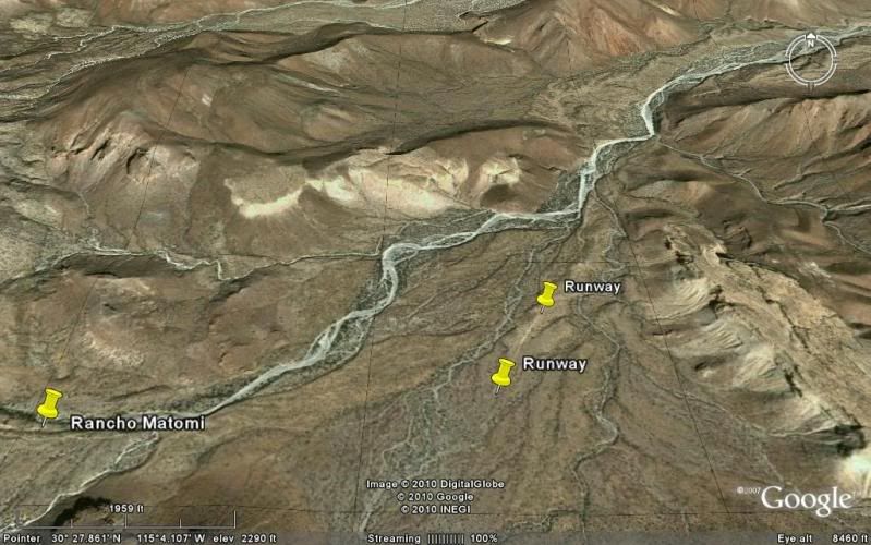
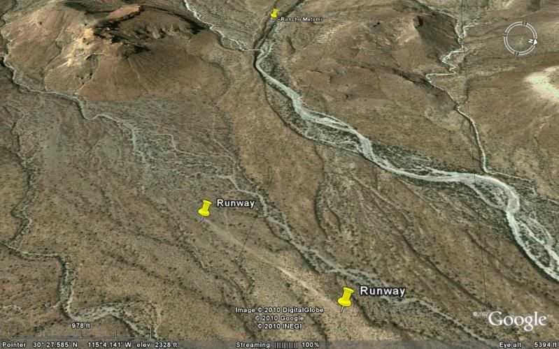
Matomi Runway
The road to the ranch/ waterfall goes right on the runway (marked at both ends and pin at ranch to the west)
|
|
|
David K
Honored Nomad
        
Posts: 65437
Registered: 8-30-2002
Location: San Diego County
Member Is Offline
Mood: Have Baja Fever
|
|
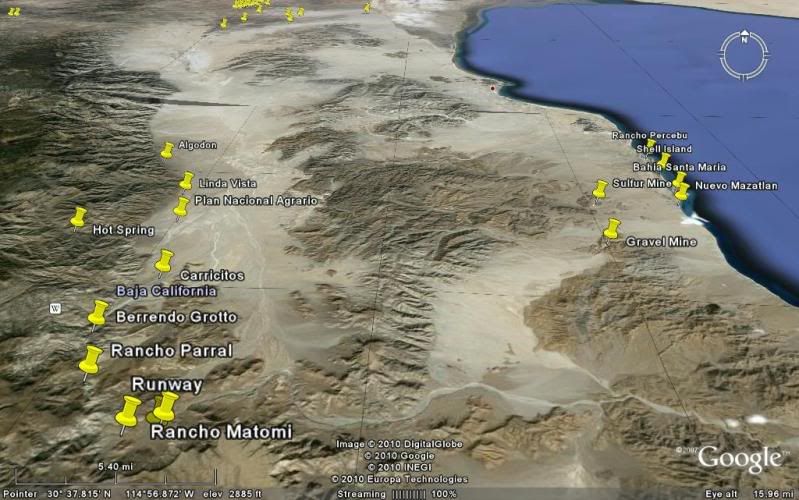
Valle Chico to Bahia Santa Maria view
|
|
|
David K
Honored Nomad
        
Posts: 65437
Registered: 8-30-2002
Location: San Diego County
Member Is Offline
Mood: Have Baja Fever
|
|
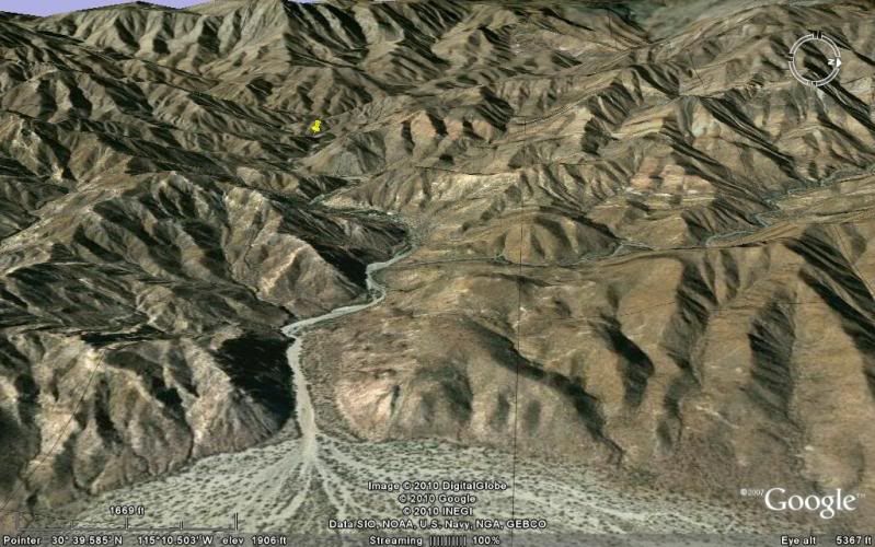
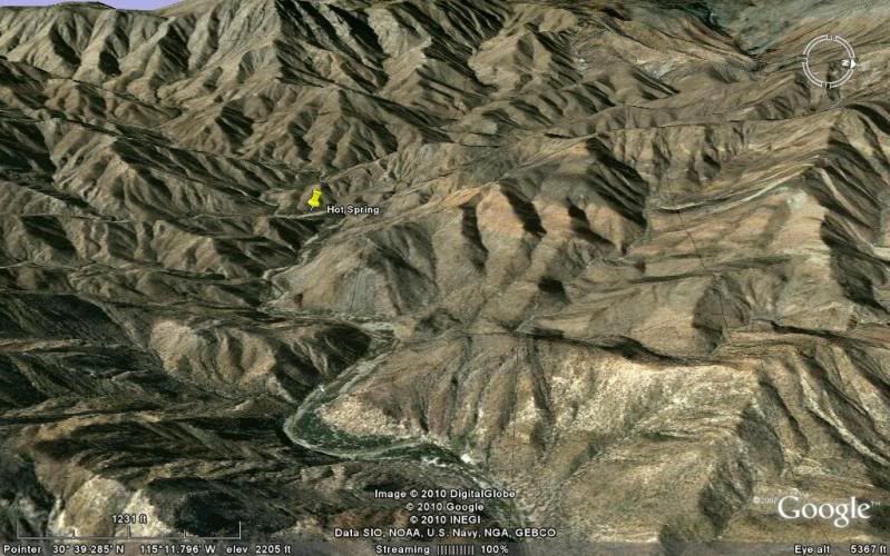
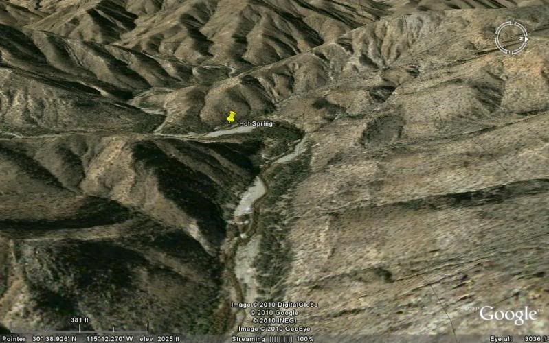
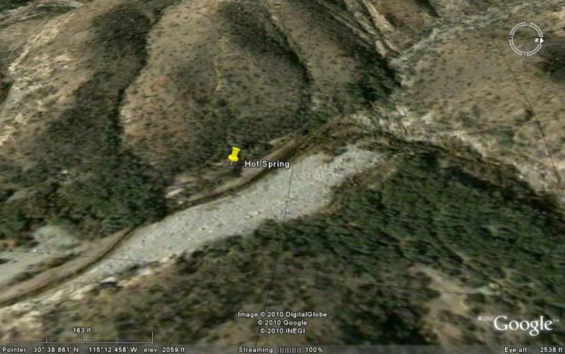
Agua Caliente Canyon
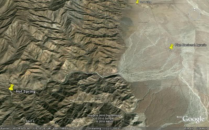
Going into the canyon to the hot spring:
Photos at the spring and other canyons at http://vivabaja.com/404
|
|
|
David K
Honored Nomad
        
Posts: 65437
Registered: 8-30-2002
Location: San Diego County
Member Is Offline
Mood: Have Baja Fever
|
|
Looking for some more details on visits to Agua Caliente Canyon by anyone...
|
|
|
BajaRob
Senior Nomad
  
Posts: 722
Registered: 9-15-2003
Location: Bahia Santa Maria y Newport Or
Member Is Offline
Mood: Life is good
|
|
Great info David, thank you. Next trip we will hike to the hot springs.
|
|
|
Barry A.
Select Nomad
      
Posts: 10007
Registered: 11-30-2003
Location: Redding, Northern CA
Member Is Offline
Mood: optimistic
|
|
When we were there, there were two great shallow swimming holes about 100 yards below the Hot Spring along the very active creek-------they were
great, and quite warm from the influence of the hot spring runoff. We camped there for several days one time, just sitting in the swimming holes
most of the time-------heaven!!!
Barry
|
|
|
BajaRob
Senior Nomad
  
Posts: 722
Registered: 9-15-2003
Location: Bahia Santa Maria y Newport Or
Member Is Offline
Mood: Life is good
|
|
Thx Barry
We will do it justice next time in, Rob
|
|
|
BajaWarrior
Super Nomad
   
Posts: 2307
Registered: 9-27-2006
Location: Mission Bay, San Diego. Playa Hermosa, San Felipe.
Member Is Offline
Mood: Anxious to get south
|
|
| Quote: | Originally posted by BajaRob
We will do it justice next time in, Rob |
Sounds like it was a great trip Rob, wishin' I was there.
Next trip south for us isn't until May 6th.
Haven't had a bad trip yet....
|
|
|
David K
Honored Nomad
        
Posts: 65437
Registered: 8-30-2002
Location: San Diego County
Member Is Offline
Mood: Have Baja Fever
|
|
| Quote: | Originally posted by Barry A.
When we were there, there were two great shallow swimming holes about 100 yards below the Hot Spring along the very active creek-------they were
great, and quite warm from the influence of the hot spring runoff. We camped there for several days one time, just sitting in the swimming holes
most of the time-------heaven!!!
Barry |
I was last there with Jide, April, 2004... The road ended 1.1 miles from the hot spring... No way could any vehicle go closer as boulders and
vegetation blocked the way. This was the same situation I saw the previous trip there on Dec. 31, 2001... The mile walk wasn't bad, and the marijuana
farm project we found in 2001 was all gone in 2004!
The hot spring flowed off the sandy bench and down about 4 feet to a man-made pool... which was far too hot to get into... the hot stream then flowed
down the arroyo floor for several hundred feet before it was cool enough to enjoy... The cool mountain stream was about 50 feet away from the hot
stream... too far to hand dig a canal... otherwise we would have had hot and cold running water side by side... and that would have been awesome!

Here see great amounts of super hot water flow out and go about 400 feet to where it merges with the cool mountain stream. HOT SPRING GPS: 30°38.85',
115°12.41', elev. 2,041'

Jide is by a hot water tub built where the spring water flows down from the terrace, then heads downstream. The water was too hot in the tub. Photo
looking south.

Photo looking north/ downstream. Here is the tub just below the spring, but the water is a scalding 140°F! We go over 300 feet downstream and make a
tub where the temperature is closer 105°F.

I climb high up the canyon for an 'almost aerial' photo (looking south) of the hot springs and hot stream, along right edge of arroyo. Beyond, at the
next bend is a lone blue palm tree.
SKY VIEW (Thanks to Baja Lou!)

Photo looking eastward, down stream. Shown (going upstream) is: the end of the 4WD road, a former cilantro* farm area, hot springs, and a palm tree
location. (*or other cash crop)
Map from 2004 trip:

Photo of me at the hot spring waterfall, 12/2001... notice the steam rising from the stream!

|
|
|
Barry A.
Select Nomad
      
Posts: 10007
Registered: 11-30-2003
Location: Redding, Northern CA
Member Is Offline
Mood: optimistic
|
|
You got me curious, David, so I just checked my slide files and note that my son and I were camping at the hot springs in Oct. of 1996-------I really
did not think it was that long ago-----time does fly.
At that time there were actually two roads that went all the way into the Hot Springs, one a very rough road right up the stream bed, and the other on
the south side of the canyon on a bench and somewhat easier to navigate, but both were pretty bad. We went in with a Isuzu Trooper and a Toyota
FJ-40, and tho very slow going it was not that bad. A 4 wheel drive pickup came in late one night while we were there, got out and approched our
camp, but when they heard our German Shepard bark vigorously they got back in there pickup and drove out the way they came in, so we did not actually
talk to them.
We camped beside a corral, on a bench, and about 200 yards upstream from the actual Hot Spring and on the same side of the canyon as the Hot Spring.
I am thinking that there must have been a flood to alter the canyon after we were there, which would explain why the "roads" no longer existed when
you were there.
It is a magical place and we lingered several days-----then pushed on to Rancho Matomi and other points south, and canyons in between (Barrendo,
Carrizo, Parral, etc.. )
Barry
|
|
|
bajalou
Ultra Nomad
    
Posts: 4459
Registered: 3-11-2004
Location: South of the broder
Member Is Offline
|
|
Hurricane Nora hit this area in September of 97. All roads washed out and spring not accessible for quite some time. As Rob mentioned rain this
spring washed out the road that was there last fall. I was there about a month ago on a quad and we were stopped by a 8 foot cliff where the road
used to go up. There was another storm since then and I would expect another cut through the canyon floor similar to the one in Canon Cajon.
No Bad Days
\"Never argue with an idiot. People watching may not be able to tell the difference\"
\"The trouble with doing nothing is - how do I know when I\'m done?\"
Nomad Baja Interactive map
And in the San Felipe area - check out Valle Chico area |
|
|
Barry A.
Select Nomad
      
Posts: 10007
Registered: 11-30-2003
Location: Redding, Northern CA
Member Is Offline
Mood: optimistic
|
|
Thanks, Lou-----that explains it. Glad we went when we did.
I am still wondering just where the "road" to Rancho Matomi P-nches out and becomes impassible? Also, I wonder if Rancho Parral in upper Parral
Canyon is still accessible?
Barry
|
|
|
bajalou
Ultra Nomad
    
Posts: 4459
Registered: 3-11-2004
Location: South of the broder
Member Is Offline
|
|
Don't know about Matomi this spring, but there has been a locked gate keeping us out of Parral for the last couple years. Haven't checked myself this
season,
No Bad Days
\"Never argue with an idiot. People watching may not be able to tell the difference\"
\"The trouble with doing nothing is - how do I know when I\'m done?\"
Nomad Baja Interactive map
And in the San Felipe area - check out Valle Chico area |
|
|
David K
Honored Nomad
        
Posts: 65437
Registered: 8-30-2002
Location: San Diego County
Member Is Offline
Mood: Have Baja Fever
|
|
BajaRob mentioned he estimated he was about 2 miles from Matomi when the washout stopped him (see above)... here's his words: "We did go in Matomi
wash from the highway. We estimate that we were 2 to 2 1/2 miles from Matomi Resort when we gave up."
For details on our trip to Rancho Parral in 2004: http://vivabaja.com/404
That trip we met Nomads: BajaLou, Taco de Baja, Mexitron, Pappy, and more!
The gate was unlocked, we drove over the runway to the corral where we all camped... the road went through the corral and eneded at the arroyo a short
distance beyon (where the road was washed out)... We all hiked the remaining mile to Rancho Parral (abandoned)... Loui and others hiked even further
up the canyon. It was a beautiful place!
Photo taken right behind Rancho Parral, 2004...

|
|
|
Barry A.
Select Nomad
      
Posts: 10007
Registered: 11-30-2003
Location: Redding, Northern CA
Member Is Offline
Mood: optimistic
|
|
We have tried to drive to Rancho Parral 3 times over the past 15 years, or so, and the gate close to the cross-over road to Berrendo Canyon has always
beeen VERY locked, and VERY secure each time, and we never had the time (or the nerve) to hike on in. The furthest south I ever got before that (back
in the early 60's) was Berrendo, with Myron Smith and Bud Bernhard, and several others. On that trip we used the mouth of Agua Caliente canyon as a
basecamp, and branched out from there for several days further south, exploring canyons as we went, stopping at Barrendo where we hiked up about 2
miles, as I recall-------blue palms everywhere in Berrendo--------I still love all that country, but the "growers" spooked us out.
Barry
|
|
|
| Pages:
1
2
3 |

