| Pages:
1
2 |
degoma
Junior Nomad

Posts: 64
Registered: 7-21-2009
Location: Mojave, CA
Member Is Offline
|
|
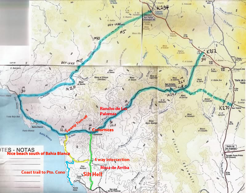
Bahia Blanca to Pta. Cono Silt Beds
Has anyone been through, silt hell between Pta. Cono and Bahia Blanca (or the other way around) recently? We were through there last summer (2009)
and
.well, but for a lucky tip from a rancher at Rancho Las Palomas we might still be there.
Inspired by TWs short trip report of 7-11-09 and David Ks map post regarding that trip (thank you two) We decided to try the KM 252 way into Pta.
Cono rather than coming down from Faro San Jose or up from Sta. Rosalillita. I have wondered about that road for a very long time
remember reading a
post about it years ago which was very discouraging.
Wow, what a nice ride in (this is summer 2009); just simply beautiful in the late afternoon sunlight and the road was a dream. A few miles east of the
Rancho Las Palomas (I think thats the name) we came to the silt beds that TW mentioned. While stopped to assess a line I noticed that someone had
been stuck right in front of where we were parked. Yiiikes, good timing on that stop.
We had a nice talk in the fading light with the rancher and his wife (whose names are in the notes I cant find at the moment). I asked him if there
was some way around those pinchy silt beds. No way he said. I told him we saw where someone was stuck muy duro (bad) in there recently. That was
us he exclaimed! He went on to tell us that if we thought that was bad, hold on to our sombreros further south towards Pta. Cono. Well, thats been
terrible for years I said (last time we were through was 2008 north bound). Si, but now its been pulverized by the big trucks hauling beach rocks
out of the Bahia Blanca. Big serious off road rigs have been getting stuck. Then he told us the way around it
take the, Mesa de Arriba. Of course,
why didnt we think of that?  (the Mesa de Arriba road shows very
clearly on Almanac pages B91 and B92) (the Mesa de Arriba road shows very
clearly on Almanac pages B91 and B92)
Heres the deal, after you turn south at Codornices you come to a 4 way intersection at about 4.8 miles. That would be 29 degrees 01.617 N 114
degrees 32.137 W (Map Datum NAD 27 Mexico hddd-mm.mmm). To the west (some very bad silt fields here as well) is a very nice beach at the extreme
south part of Bahia Blanca (Its around the point at the south end of the sweeping Bahia so its not really in BB). This is also a way go from that
beach to Pta. Cono along the coast. Yes, thats correct we did it in summer 2008. You can see the trail on G. Maps but thats another story.
Straight takes you to the road to Pta Cono (if youre lucky). Turning east you go up to the much touted Mesa de Arriba and around and about and end
up on the main road a couple of miles south of where going straight (through the silt beds) comes out. I would say it was 7 or 8 miles to the main
road that way. Very nice scenery, little used road and, no silt. A bonus was a nice pile of beach rocks where some truck apparently gave it up.
Years ago when I asked Oscar at Ranch Santa Ines what he thought of the new paved road (hwy 1) he said, Good roads bring bad people, bad roads bring
good people. We agree and we like bad roads but the silt beds are something else again. For once I would welcome a slightly improved road.
Thanks for any current info on that stretch.
PS to TW
summer 2008 we went out to the highway from La Vibora to Laguna Chapala the way you came in on the 7-09 short trip. It was to say the least
a very bad road. The silt beds were a challenge then when we got up to the high ground large grape fruit to basketball sized rocks slowed us to about
half walking speed for a very long time. Throw in a flat along the way and another one the next morning and we are not in a hurry to go that way
again (well try some other bad road instead). Sounds like it got graded that next year. We actually met a Mexican lady and her husband who
claimed to own La Vibora and everything as far as you could see (according to her). She said they were going to improve that road and then charged us
retro-actively for camping there. Its another story
.sorry I have been a lurker on this board
.I should/will post more and with pictures and
maps
.just too busy at the moment getting ready for this summers trip. Lets went to Mexico!

[Edited on 7-14-2010 by degoma]
|
|
|
David K
Honored Nomad
Posts: 65563
Registered: 8-30-2002
Location: San Diego County
Member Is Offline
Mood: Have Baja Fever
|
|
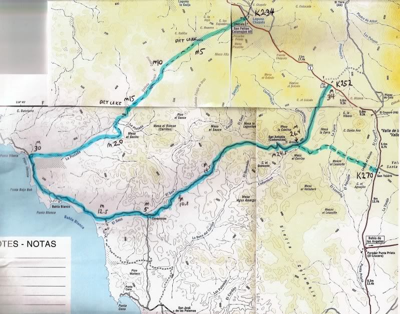
Welcome to Nomad! Maps are great to visualize things...
The first one is TW's route:
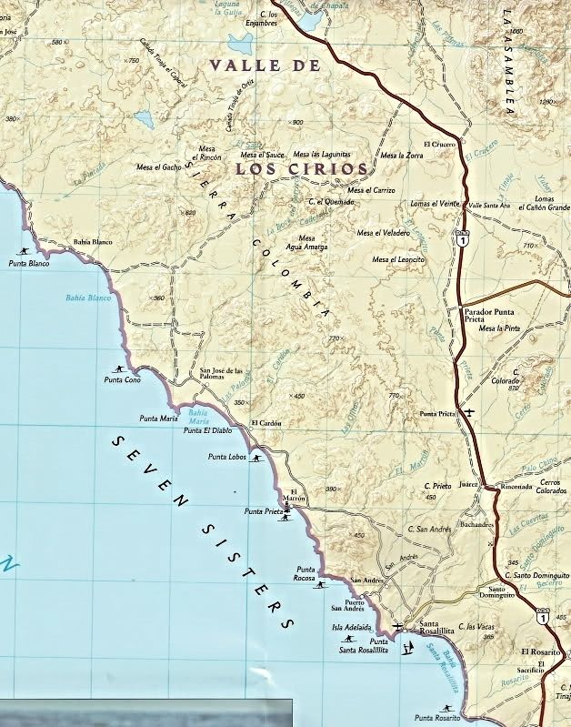
The general area:
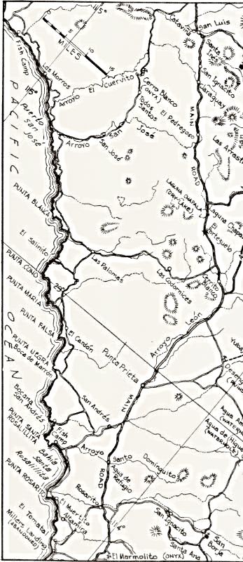
Back in 1962:
|
|
|
degoma
Junior Nomad
Posts: 64
Registered: 7-21-2009
Location: Mojave, CA
Member Is Offline
|
|
Thanks David! Maps are absolutely essential for these descriptions. I go nuts trying to understand a description like the one I just wrote without a
map.
|
|
|
Sunman
Nomad
Posts: 400
Registered: 6-22-2007
Location: Oxnard
Member Is Offline
|
|
Got through it (barely) solo in November. Lots of stopping and scouting (mixed with intermittent crapping of myself). Can't imagine what the winter
rains did to it.
On a side note I was south of there again for Xmas/New Years with plans to leave via the North, being solo again I opted to stay put and not push my
luck.
[Edited on 7-15-2010 by Sunman]
|
|
|
Taco de Baja
Super Nomad
Posts: 1913
Registered: 4-14-2004
Location: Behind the Orange Curtain, CA
Member Is Offline
Mood: Dreamin' of Baja
|
|
| Quote: | Originally posted by degoma
..... We actually met a Mexican lady and her husband who claimed to own La Vibora and everything as far as you could see (according to her). She said
they were going to improve that road and then charged us retro-actively for camping there. |
I too have met Maria Luiza, the owner of a large area of coastline, and her husband (Pepio, or something like that), she does most of the
talking... ... Very nice woman. We too have paid for camping on her property,
although she collects while we are there. Last I heard she had sold some of her land to a preservation group in 2009, dont know if it is true or
not, but we did not see her last year to collect dinero, so maybe its true. She often asked it we wanted to buy land....but with the Federal Zone,
issues with gringos buying land, the remoteness, and not really wanting to risk the money, etc we always declined. ... Very nice woman. We too have paid for camping on her property,
although she collects while we are there. Last I heard she had sold some of her land to a preservation group in 2009, dont know if it is true or
not, but we did not see her last year to collect dinero, so maybe its true. She often asked it we wanted to buy land....but with the Federal Zone,
issues with gringos buying land, the remoteness, and not really wanting to risk the money, etc we always declined.
Can't comment on the road as we access that portion of the Coast from San Jose, which is usually a decent drive, albeit slow in some areas south of
San Jose because of washouts and steep hills.
Truth generally lies in the coordination of antagonistic opinions
-Herbert Spencer
|
|
|
woody with a view
PITA Nomad
Posts: 15940
Registered: 11-8-2004
Location: Looking at the Coronado Islands
Member Is Offline
Mood: Everchangin'
|
|
252 at the silt was hell in april. we ended up going out to the north instead of trying a south run like we'd planned as we were alone and Bia was
freaking out. in feb we were told the military guys were stuck in the muck for 2-3-4 days in their hummer until help arrived/found them.
|
|
|
degoma
Junior Nomad
Posts: 64
Registered: 7-21-2009
Location: Mojave, CA
Member Is Offline
|
|
| Quote: | Originally posted by woody with a view
252 at the silt was hell in april. we ended up going out to the north instead of trying a south run like we'd planned .. |
Was that the silt East of Rancho de Las Palomas or was it closer to the coast on that same general road...west of Codornices?
|
|
|
woody with a view
PITA Nomad
Posts: 15940
Registered: 11-8-2004
Location: Looking at the Coronado Islands
Member Is Offline
Mood: Everchangin'
|
|
for miles before the "intersection" of the coastal road. having heard of the military guys being stuck we figgered we didn't want to chance it alone
so we stopped by Mike and Bobbie's place and continued along that way. the road from the faro to the hiway was tore up from the rain.there are areas
with silt forming that haven't been there the past 6-7 years.
|
|
|
surfer jim
Super Nomad
Posts: 1891
Registered: 8-29-2003
Location: high desert
Member Is Offline
|
|
When I read this I say to myself.....
I want to go.
I don't want to go.
I want to go.
I don't want to go.
Where does it end
|
|
|
TMW
Select Nomad
Posts: 10659
Registered: 9-1-2003
Location: Bakersfield, CA
Member Is Offline
|
|
I always want to go there. The fun of getting stuck is getting out. During the 2000 Baja 2000 race I got my chevy 4x4 stuck in the silt south of San
Ignacio and out of the bushes came 20 Mexicans. They surrounded my truck to try and lift it up and out. Frankly I was very amused by that since it
was a 5000 lb truck with a motorcycle and tons of other stuff in the bed. They couldn't budge it. I asked if anyone had a 4x4 and yes a young man got
his litttle Ford Ranger and popped me out. For that I gave him a $20 bill and my non-drinking brother gave him a 12 pack of non-alcoholic beer and we
hauled a$$ before they knew it was non-alcoholic.
|
|
|
surfer jim
Super Nomad
Posts: 1891
Registered: 8-29-2003
Location: high desert
Member Is Offline
|
|
Yeah, I hear you TW. If you make it through there is no story to tell , but you will always remember the times it wasn't so easy.
|
|
|
TMW
Select Nomad
Posts: 10659
Registered: 9-1-2003
Location: Bakersfield, CA
Member Is Offline
|
|
Where the road turns east from the coast at La Vibora to Laguna Chapala was the original Baja 1000 race course in 2003. During pre-running so many
racers were having problems with the silt right after the turn east that SCORE changed the race course and used a route further north that took them
to Catavina and used the hwy down to Chapala. We pre-ran it as soon as the course was open and the silt was not a problem. I thought it was a pretty
good route to Chapala then. But rain plays a lot of tricks on dirt roads in Baja. What is good today becomes impossible tomorrow.
|
|
|
Mexitron
Ultra Nomad
Posts: 3397
Registered: 9-21-2003
Location: Fort Worth, Texas
Member Is Offline
Mood: Happy!
|
|
Probably a good thing to keep the race out of there and keep from further mangling the roads---Taco de Baja and I drove through the connector road
from the Chapala road to P. Blanca a few years back and couldn't believe how torn up the valley was after a race.
|
|
|
degoma
Junior Nomad
Posts: 64
Registered: 7-21-2009
Location: Mojave, CA
Member Is Offline
|
|
Oh silt, why for art thou? A few years ago Wild Bill told me he was stopped in a big silt stretch (I didnt ask how he happened to be, stopped
there) and when he got out he sunk right to his knee cap (hes 6-4 so figure about 2 deep). No wiggling or anything
just wooosh down. My truck is
on the frame at 18 and theres plenty hanging below the frame here and thee.
Silt is here and there all around the peninsula but this stretch between Bahia Blanca and Pta. Cono seems to be particularly pesky. My sense is that
bit of road is practically impassible now. The race always freshens up the silt but I think the spate of beach rock hauling last year might just have
been the coup de grace.
It doesnt matter if you take the yellow road or the green road (see the map in my first post
.thanks David K.) The silt is very serious. Two years
ago we were headed north through Silt Hell and congratulated ourselves upon reaching the 4 way intersection
we made it, the worst was over. We
freshened up our coffee and headed west on the yellow road.
The last time we went via the yellow road was a few years before and it was a piece of cake. Not this time (7-08). Always trying to hit the right
line at the right speed I realized I had missed something and it wasnt good. Visibility went to zero, we were bogging
oh no! I gunned it (yea
right, try gunning a 7.3 normally aspirated diesel) and held the line since there was nothing else to do other than stop and Ive never voluntarily
done that in the silt. All of a sudden myself, my girlfriend, her brother-in-law, the dog and our coffees were all pinned to the ceiling. About the
time we returned to our seats the truck came out of the silt fog onto Tierra Firma. Whew! We came very close to having some, fun. Ive had my
share of, fun over the years and its true what TW says about the unforgettable adventure of it all. We were glad to be out anyway.
There is a way to transit that area
we took it in summer of 08. I call it the Costal trail. But like TW said, the roads are different every time.
Like now, whats it like after the Swamp Turn Off? Its been pretty wet sometimes. Transiting the south side of the Estero on the blue road/trail was
very hummocky with tight little turns (a bother for an xtra cab truck). From the point at the south end of the, nice beach the trail does a
moderate steep climb up the hill. With heavy rain I could see this developing the oh so bothersome deep gullys parallel to the trail. After that
climb out there a numerous ups and downs and the downs look like the could wash out in a heart beat and require hours if not days of filling.
It was a fun ride
just the right amount of adventure for a heavily loaded pickup traveling alone. We are headed down next week but after the heavy
rains I think we will just whimp out and come in from the south this time. Perhaps Ill take a run up that way after we are setup.
We would love to get away from the single vehicle mode and hook up with someone else for some
..fun.
|
|
|
TMW
Select Nomad
Posts: 10659
Registered: 9-1-2003
Location: Bakersfield, CA
Member Is Offline
|
|
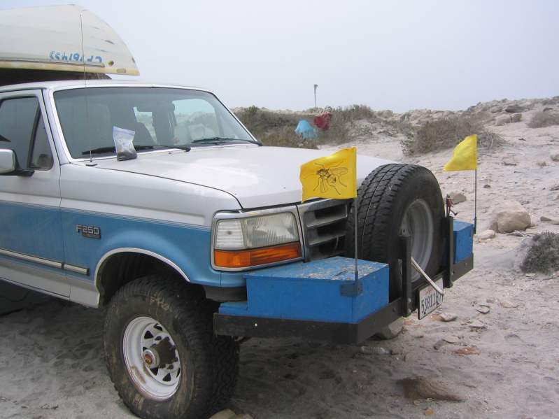
That's an interesting front end setup. Can I assume you haven't had any cooling temp issues at hwy speed.
|
|
|
degoma
Junior Nomad
Posts: 64
Registered: 7-21-2009
Location: Mojave, CA
Member Is Offline
|
|
Only one time did I start to see a climb and that was a very hot summer day, north bound up the Cajon Pass (returning from Mexico) AC running of
course and, a screaming tail wind. Of course it could have been caused by that pelican head I crammed in there that trip.
I was concerned about cooling when I did it so did a quick lash-up and drove it all around in the summer. No problem so I made it real.
|
|
|
Sunman
Nomad
Posts: 400
Registered: 6-22-2007
Location: Oxnard
Member Is Offline
|
|
Your story of gunning it and getting airborne sound all to familiar. I did pretty much the same thing and in the end ripped two of the eyebolts out of
my Four Wheel Camper, had to use tie downs for the rest of the trip. I made it, but no friggen bueno.
Southbound in a few hours...tic-toc  . .
|
|
|
woody with a view
PITA Nomad
Posts: 15940
Registered: 11-8-2004
Location: Looking at the Coronado Islands
Member Is Offline
Mood: Everchangin'
|
|
have fun Sunman...... too bad the swell wont be filling in past the viz.......
|
|
|
Sunman
Nomad
Posts: 400
Registered: 6-22-2007
Location: Oxnard
Member Is Offline
|
|
Gracias Woody, I'll be plenty south of that land mass! 
|
|
|
woody with a view
PITA Nomad
Posts: 15940
Registered: 11-8-2004
Location: Looking at the Coronado Islands
Member Is Offline
Mood: Everchangin'
|
|
get 2 for me......
|
|
|
| Pages:
1
2 |


