56MM#
Junior Nomad

Posts: 59
Registered: 2-3-2010
Member Is Offline
|
|
El Mano Canyon
Am planning a trip to El Mano Canyon this Saturday. We expect to leave early Saturday morning and come home Sunday morning. We intend to maximize
daylight understanding that there are only 11 or so hours available. Several questions:
- To get from downtown to the Guadalupe Canyon turnoff from hwy 2, is it faster to cross at Tecate and take hwy 2 east or cross at Calexico and
backtrack west on hwy 2? Advantages to the former are less road miles and getting to Mexico faster. Advantages to the latter appear to be less
delays from toll booths and checkpoints, later fillup with American gas and more logistical choices in Calexico.
- Have not done this route for about 1-1/2 years. Any recent changes?
- Coming home from the top of El Mano Canyon, is it faster to go north through Laguna Hanson and cross at Tecate or go south to hwy 3, go west to
Ensenada, then north to TJ?
- There is a road depicted on page 3 (coordinates L1) of the Baja Almanac that goes south to Agua Caliente. Is this road worth taking? In what
condition is this road and how long will it take round trip in a 4WD from the turnoff to El Mano Canyon?
- Can one buy a two-day Mexico insurance policy on line? If so, what is the most reputable company? Again, the goal is to minimize delays at the
border.
Appreciate any information that you all can provide.
|
|
|
surfer jim
Super Nomad
   
Posts: 1891
Registered: 8-29-2003
Location: high desert
Member Is Offline
|
|
I hope the "map police" don't jump all over this like the last topic.
Is this a "jeep" trip?
|
|
|
David K
Honored Nomad
        
Posts: 65436
Registered: 8-30-2002
Location: San Diego County
Member Is Offline
Mood: Have Baja Fever
|
|
hi. i am posting from my phone so cant add maps yet. i would go from tecate to laguna salada to mano then north back to tecate. this is my opinion as
it has been 7 years since last time in mano canyon. i have gps of the route i took on my gps page at www.vivabaja.com.
|
|
|
David K
Honored Nomad
        
Posts: 65436
Registered: 8-30-2002
Location: San Diego County
Member Is Offline
Mood: Have Baja Fever
|
|
Maps
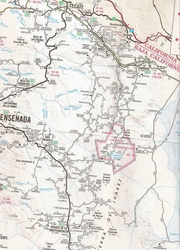
The bigger area so you can see the extra distance going home via Ensenada would be...

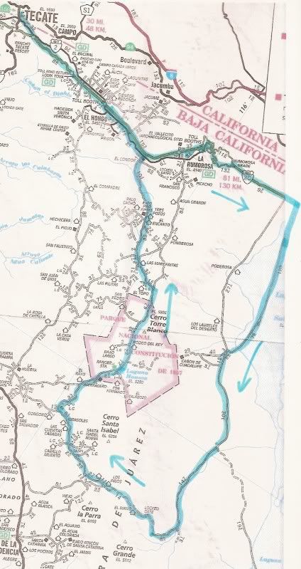
Now, a closer look with a possible route to take...

El Rayo north almost to Hwy. 2 at El Condor is where Mike and the burro recently walked, southbound.
|
|
|
56MM#
Junior Nomad

Posts: 59
Registered: 2-3-2010
Member Is Offline
|
|
David, thanks for your detailed response. I plan to write a trip report to post next week.
|
|
|
David K
Honored Nomad
        
Posts: 65436
Registered: 8-30-2002
Location: San Diego County
Member Is Offline
Mood: Have Baja Fever
|
|
Awesome! 
|
|
|
Ken Cooke
Elite Nomad
     
Posts: 8970
Registered: 2-9-2004
Location: Riverside, CA
Member Is Offline
Mood: Pole Line Road postponed due to injury
|
|
I second David K's trip route...with ONE exception
Gasoline can be stocked up in the outskirts of El Progreso along Hwy 2 (15 min. East past Laguna Salada). You will need to be stocked up on gasoline
along this route. Have fun and please post pictures of your trip.
|
|
|
David K
Honored Nomad
        
Posts: 65436
Registered: 8-30-2002
Location: San Diego County
Member Is Offline
Mood: Have Baja Fever
|
|
Gasoline is for sale at the Pemex in La Rumorosa... If you are on the toll highway, exit at the Vallecitos exit (which is just west of La Rumorosa)
and go to the free road and continue towards town...,. The Pemex is on the left... then continue east and you will join the toll road for the trip
down the mountain... Top off your tank in Rumorosa, or bring extra cans and fill them in Tecate or Rumorosa, as there are two Pemex stations on the
free road east of Tectae before you would hop onto the toll road. No need to go way past Laguna Salada towards Mexicali for gas and double back...
IMO.
|
|
|

