Steve&Debby
Nomad

Posts: 335
Registered: 12-18-2007
Location: Colusa,California/ Percebu
Member Is Offline
|
|
Off Road From San Felipe To Cabo
Is it possiable to go from San Felipe to Cabo off road with a 4x4 like a Jeep or Toyota? I see the motorcycle people run quite a ways,but it looks
like alot of the travel is on cow trails just wide enough for the bikes.
|
|
|
David K
Honored Nomad
Posts: 65563
Registered: 8-30-2002
Location: San Diego County
Member Is Offline
Mood: Have Baja Fever
|
|
You need to get a Baja Almanac, as it shows many more dirt roads than other maps first off. Then... you do know that they are paving the road to
Gonzaga Bay... so much of the former road is obliterated by the new.. Just beyond Coloradito to Puertecitos also finds the paved road on top of the
old road...
Even the Baja 1000 next week is using paved roads where there are no options. You will have some more pavement going into L.A. Bay, then again going
into San Ignacio... Here and there...
You could use the Baja 1000 map and just use that route from San Felipe to La Paz... La Paz to Cabo could be interesting to try and avoid the
highway... See the Baja 2000 race course, which eneded in Cabo (in 2000).
If you need some assistance in mapping a route, let me know!
|
|
|
TMW
Select Nomad
Posts: 10659
Registered: 9-1-2003
Location: Bakersfield, CA
Member Is Offline
|
|
You can drive on dirt roads probably 90% of the way. From say Rancho Santa Veronica near Tecate you can come out near Trinidad, a little hwy, and go
thru Mikes Sky Ranch down near Santo Domingo to hwy 1 near Arenoso, off hwy 1 at Guayaquil. Follow the coast to Bahia Blanco turn east to hwy 1 at
KM270 cross over toward the El Desengano AB gold mine and follow the 1000 course to the BOLA hwy. Out of BOLA use the 1000 course to hwy 1 and on to
San Ignacio and again follow the 1000 course to the La Paz turn off but go straight south to Todos Santos and follow the dirt roads to near Cabo San
Lucas. You will have traveled about 1200 milkes total with maybe 100 miles on the pavement. Take a fishing rod and camp near the ocean during your
travel and eat fresh fish and sip wine while watching the millions of stars overhead.
|
|
|
David K
Honored Nomad
Posts: 65563
Registered: 8-30-2002
Location: San Diego County
Member Is Offline
Mood: Have Baja Fever
|
|
They are starting in San Felipe, Tom...
1) Old Puertectos road south until it joins pavement.
2) Pass Gonzaga Bay to Coco's Corner... then a choice:
a) Go to Laguna Chapala, then the unmapped road from there to the Pacific Coast, follow the coast south to Hwy. 1 south of Rosarito/ north of Villa
Jesus Maria, then get on the old road to El Arco... south to San Ignacio joining Hwy. 1 near Vizcaino.
b) Go to Calamajue Canyon (Baja 1000 course) to Desengaño (see TW route above) then either through L.A. Bay and south per TW/ Baja 1000 route, OR
c) go through Mision San Borja to Rosarito then old road south of Rosarito to El Arco and south.
|
|
|
windgrrl
Super Nomad
Posts: 1336
Registered: 9-2-2006
Member Is Offline
|
|
The Baja Almanac is indeed a good thing...
When the way comes to an end, then change. Having changed, you pass through.
~ I-Ching
|
|
|
Neal Johns
Super Nomad
Posts: 1687
Registered: 10-31-2002
Location: Lytle Creek, CA
Member Is Offline
Mood: In love!
|
|
Don't forget to use Google Earth to find possible unmapped roads needed to bypass pavement.
My motto:
Never let a Dragon pass by without pulling its tail!
|
|
|
Steve&Debby
Nomad
Posts: 335
Registered: 12-18-2007
Location: Colusa,California/ Percebu
Member Is Offline
|
|
We would like to stay near the beach or on the beach as far as possible.A couple of years ago we were in L.A. Bay and we went north as far as we
could,staying as close to the water as we could.The road/trail went to the top of a hill the turned to a one lane goat trail.we could see what looked
like a road further up the beach.It looked like you could get to it by taking a road that went up a ravine away from the beach,but we ran out of time
to explore some more.
|
|
|
David K
Honored Nomad
Posts: 65563
Registered: 8-30-2002
Location: San Diego County
Member Is Offline
Mood: Have Baja Fever
|
|
Baja has two coasts... and you can travel along either or both!
Since you are starting in San Felipe and will go to Coco's Corner first... at that point you can jump over to the Pacific from Laguna Chapala and then
south along the Pacific to near Rosarito... then south on the old main road to El Arco (see above).
The other route keeps you on the gulf side longer... turn left at Coco's Corner, go 6.6 miles and turn right to go to Calamajue Canyon and south to
L.A. Bay and south to San Francisquito, then towards El Arco, turning left for the Guillermo Prieto/ Mision Santa Gertrudis shortcut.
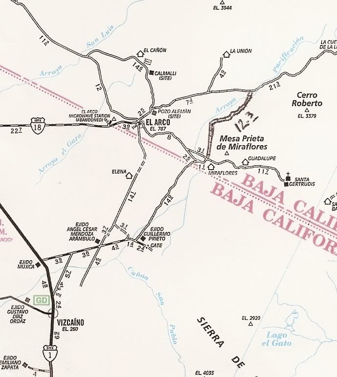
Here is the AAA map with some other roads added in... including those north of L.A. Bay and the Laguna Chapala to Pacific Coast road I mentioned:
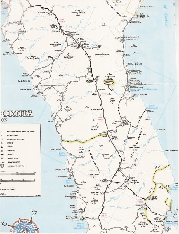
Here is a close up of the Guillermo Prieto/ Mision Santa Gertrudis Short cut:
|
|
|
David K
Honored Nomad
Posts: 65563
Registered: 8-30-2002
Location: San Diego County
Member Is Offline
Mood: Have Baja Fever
|
|
TW's Map
I drew in the new road from Laguna Chapala to the Pacific and the other routes via San Antonio to the Pacific from following the roads on Google Earth
and TW's gathered mileage data:
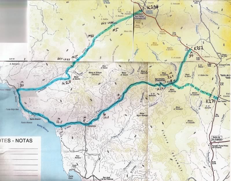
[Edited on 11-17-2010 by David K]
|
|
|
Steve&Debby
Nomad
Posts: 335
Registered: 12-18-2007
Location: Colusa,California/ Percebu
Member Is Offline
|
|
I was just looking on google and it looks like there is some lakes in the hills just south of where it says calamajue.Are they lakes or just
shadows?If they are lakes, are there any roads to them? Also it looks like there might be some old roads that go around Punta Final.Those coves look
pretty nice.
|
|
|
David K
Honored Nomad
Posts: 65563
Registered: 8-30-2002
Location: San Diego County
Member Is Offline
Mood: Have Baja Fever
|
|
| Quote: | Originally posted by Steve& ebby ebby
I was just looking on google and it looks like there is some lakes in the hills just south of where it says calamajue.Are they lakes or just
shadows?If they are lakes, are there any roads to them? Also it looks like there might be some old roads that go around Punta Final.Those coves look
pretty nice. |
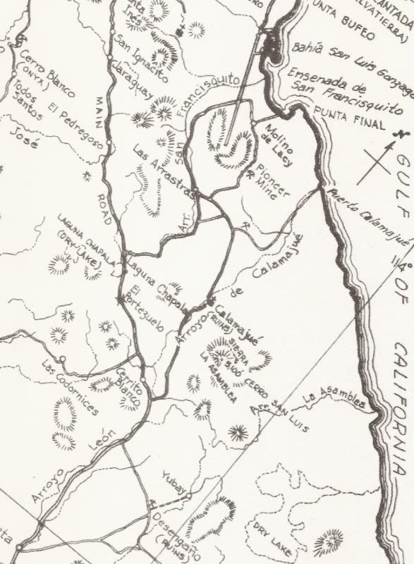
After a rain, lakes may form... Laguna Chapala was full of water earlier this year... and there are other 'lakes'. As for what you saw... If you are
using Google Earth, Google Maps/ satellite, or Wikimapia satellite you should be abble to see if there are any roads the same as me... just zoom in
and use your mouse to move around Baja! The terrain south of Gonzaga is pretty tough... There is an old mine road from Molino de Lacy to the Puerto
Calamajue road via the Pioneer Mine... It is used only by motor bikes now. There is also an unmapped road from Calamajue Wash to the gulf coast, south
of Puerto Calamajue. Coco says it is used by drug runners! 
1962 map:
[Edited on 11-17-2010 by David K]
|
|
|
Steve&Debby
Nomad
Posts: 335
Registered: 12-18-2007
Location: Colusa,California/ Percebu
Member Is Offline
|
|
Thank You all for the help.Looks like a lot of places to explore.
|
|
|
David K
Honored Nomad
Posts: 65563
Registered: 8-30-2002
Location: San Diego County
Member Is Offline
Mood: Have Baja Fever
|
|
A complete lifetime can be spent exploring Baja... I know!! LOL and you still can NEVER see it all!!
|
|
|
David K
Honored Nomad
Posts: 65563
Registered: 8-30-2002
Location: San Diego County
Member Is Offline
Mood: Have Baja Fever
|
|
The Pioneer Mine, between Punta Final and Coco's Corner (or Calamajue Mission)... reminded me about Mike Humfreville's post on his visit there way way
back in the day!:
------------------------------------------------------------------
The Mine ( Posted December 17, 2002 )
In the late '60's, my brother, Tony, and I were returning from an adventure out to Malarrimo. We decided to take the old turnoff for the east coast
road at the small ranch where the east road cut off from the then fully dirt transpeninsular "highway".
We spent the night near old El Crucero. I had met the family living there years before, on my first Deep Baja Adventure, with Epifanio Ybarra, from
previous stories. Tony and I threw our sleeping bags on the warm sands, climbed onto padded surfaces and tossed around enough to make the sand conform
to our individual body shapes. We talked for a while across a small fire before falling asleep, thoughts of wayward snakes and scorpions crawling into
our sleeping accommodations. Perhaps the smoke from the small dying fire would drive them away?
The next morning we said adios to the rancher and his wife and were off north up the worst road on the entire peninsula. My old Land Cruiser, La
Tortuga, was worn down from the sands of Malarrimo. I was hoping she was up to the grueling trip ahead.
The road at first is sandy and narrow, passing between lively cactus gardens filled with many of the smaller endemic species of cacti growing right up
to the edges of the road. Sometimes it was hard to get out of the vehicle they were so close to the dirt roadbed. A very attractive area.
Soon we were making tight corners and I had to back up and try a second time. That's how sharp the corners were, even in the stubby Tortuga. Large
boulders, smaller but ala Catavina style, made the turns even tighter. Then we encountered a small stream.
"Am I hallucinating?" I ask Tony.
"Me, too, I guess."
The stream is glued to the center of the roadbed and we had no choice but to follow it. It grew deeper as we continued north, but Tortuga is a heavy
lady and was well endowed with not only 4WD but high and low range as well. Just for thrills she also had a PTO winch. She was, by then, Baja proven.
We plugged along, stone-by-watercovered-stone, for an hour or more before we encountered the Calamajue Mission, stopped for a visit and then
continued. From there, the road climbs from the small creekbed we had followed for miles and onto the central desert and continues, fairly flat and in
the general direction of Gonzaga Bay. Soon we were closing on a range of hills, moving in from east of the road. Then the mountains, decomposing
granite, covered with sparse vegetation, are enticing us, calling to Tony and me to look closer into their ravines and small valleys, to become more
intimate. We spot a site where it looks like a two-wheeled cart or wagon might have rutted earth a century or more before.
"Let's go for it." Tony says.
"Absolutely." I echo.
I pull the steering wheel to the right, following the barely detectable indentions in the weedstrewn desert, east up into the foothills. Soon we are
winding up a threateningly narrow canyon below two towering peaks of loose stone, one on each side and I'm a So Cal boy. I'm thinking "No Earthquakes
Please" and issuing this request to On High. But I'm forced now to focus on the canyon we've chosen, where the road no longer exists. We're now in 4WD
and I'm downshifting into low range. We're creeping at 1-2 MPH over raw granite in our narrow channel between hills while banging sideburns on
sidewindows. We climb maybe two miles from the main road and clamor around a corner turning south and then in front of us is a small decomposing adobe
hut, maybe a hundred years old and completely unattended. Abandoned for decades. We stop and shut down old Tortuga, sputtering with pre-carb and
spewing oil everywhere and check out the area. Although only a few miles from the main road, we're way into the backcountry. Nobody has been here for
many years.
Tony and I look for artifacts, signs of life, around the hut where people once lived and then scan the surrounding hillsides. Nothing.
"Why would someone live here? Tony asks. I'm wondering the same thing and thinking.
"Water source?" I ask "Maybe gold or silver?" We lift our eyes higher on the imposing mountains.
"Look there." Tony says. I look where he's pointing. There is a small indention in the hillside several hundred feet above our rockstrewn canyon. We
climb slowly to the dent there. While we chose the route without thought, it wasn't without ingrained logic and we soon find ourselves climbing a
steep path where we sense others preceded us many years ago. We continued climbing, slipping in the decomposing granite, climbing again. Soon we?re
nearing the small place we had noticed from below, then pulling up onto a small earthen table. We catch our breath and scan the desert below, full of
breathtaking panoramas. Behind us, tunneling into the hillside, is the mouth to a mine. We must have had some concept of this from the time we left
Tortuga, because we had flashlights with us.
"Are we up to this?" One of us asks.
"Come too far to go back with no adventure." the other responds. And off we go, down into the mine. And I'm no spelunker. I'm a damn claustrophobic;
that's why I like Baja. It's wide open.
But this doesn't stop Tony and he's forging ahead, yards ahead of me into the black shaft that heads into mother earth at an angle about 20 degrees
south of horizontal. Out come the lights and I'm watching for nasty critters and wondering what we're getting into.
We progress several hundred yards into the tunnel. It's absolutely black and noiseless except for the sounds of our boots on small granite pieces and
our lungs working and some occasional, unpredictable and mysterious sound I can't identify but don't like. At least they're no damn bats! I hate bats!
We keep moving downward. The flashlights cast tunnel vision into the blackness ahead and we're feeling the walls of the mine for assistance. What
creatures are thriving there? We check out both sides of the tunnel just to assure ourselves. We shine lights on both sides. Here is a clue as to the
purpose of this scary sinew running deep into the tissues of the earth. Along both sides our flashlights expose two parallel lines of red clay inside
of which are positioned layers of clear quartz. Inside the inner walls of quartz we could see a subtle change in the quartz's composition and spotted,
in the now-dimming battery-powered flashlights, a substance that appeared to be gold.
Now that we understood what had caused someone to settle this far out in the badlands, we were further motivated and continued, expending the limited
resources of our bodies and flashlights down deep into the earth where no one had passed for maybe a hundred years. I'm thinking EARTHQUAKE! We
continue on for several hundred yards. The path is so steeply downhill I'm bringing up issues about our ability to extract ourselves from this black
pit. Tony's huffing and puffing. Soon, though going downhill, one of us is suggesting that maybe we need to just take a break and sit down on a rock
in the darkness, turn off our lights and rest for a minute. In the last hundred yards the temperature has gone up considerably. Suddenly, alarms are
going off in my head.
"Rest here?" I shout to Tony. My mind is working overtime. My call echoes around the sides and then the end of the cave, bouncing back to us at varied
intervals and I'm realizing that we might be encountering thinning oxygen or a buildup of other obnoxious gasses and slowly growing delirious. I only
want out of here.
"Let's head out." I shout. "Now!" Tony agrees and we begin the climb that could have claimed our young lives. Going down into that great void we were
working with gravity. The energy we were expending was small and resisting the pull. Going down we only noticed the effect of whatever was now messing
with us in a way that was not influential. But going up was another matter and soon we were almost unable to move, unable to capture lungsfull of air
and staggering, then crawling, then pawing the dry, so dry earth and with my face on the floor, inhaling it, sucking life out of my body, still deep
in the lower intestines of earth but Tony'd kick me and I'd prod him on as we worked for the surface and rued the decision we'd made to come here. We
mentally composed our final farewells. We knew we were goners.
We move on, now down to a barely visual motion. This continues for what seems like hours. I don't know where I'll find the air to feed my muscles that
drive my momentum. I realize this is a mind deal. This concept throws a binary switch deep inside me. If I'm going to survive this I have to focus.
There's no time to consider the problem, just figure out HOW TO SOLVE THE PROBLEM! We just need to get out of that damn shaft!
We worked up the black angle toward where we knew the surface was for an hour or more. When one of us grew silent for more that a few seconds the
other would call out and not proceed until we heard a response. There was no progress until we were together regardless, and the going was slow. But
then the air seemed richer. We weren?t breathing as heavily and our heads were clearing and we were returning to the normalcy of self-preservation,
rather than -sacrifice. I was glad to hear that as I rather enjoy life over the alternative.
Then we're seeing small modulations of light and enthused and motivated if just from the fact that we may have survived. We're on our knees now, then
staggering, punch-drunk legs and then standing at the mouth of the mine and sucking in great gulps of the best air we'd ever inhaled and realizing
that we'd been under some influence ever since we'd entered that mine. Perhaps old mining chemicals decay across decades? Maybe the natural
decomposition of natures elements are additive? Maybe just the phenomenon of air thinning the deeper it gets in a tunnel into the earth. I just don't
know.
We sat, and then stood, at the mouth of the mine for a while, then, Tony and me, reflecting on the incident. As guys do, we laughed and kidded about
the risks and became closer, much in the same way two men do after a fight. Surviving serious difficulties we males are most likely to open ourselves
to our perceived opponents. I knew him more closely than I do now. But he's eleven years younger than me and just a kid.
We reclaimed the wondrous Tortuga, waddled across stones down narrow canyons, returned to the old dirt road, sandy and relatively smooth that far
north, and sped toward Alfonsina's. Many miles before we reached her then outpost, while we were still far off in the desert, we could smell the
turtle steaks cooking, smothered in garlic. That was back in the days when none of us was endangered. The land of plenty?
--------------------------------------------------------------------------
[Edited on 4-14-2011 by David K]

|
|
|
|


