| Pages:
1
2
3
4 |
Blair
Junior Nomad

Posts: 63
Registered: 5-19-2010
Location: El Cajon Ca
Member Is Offline
Mood: Getting ready to go again
|
|
Guajademi Canyon Road?
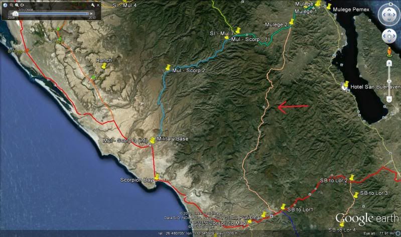
Ok road experts, does anyone know if the road on this attached pic is passable (red arrow)? Anybody with any experience with it? We are doing our
third annual bike trip in April and I was considering giving it a shot. I'm not even sure if Guajademi Canyon is the right name. That area is
beautiful and I was hoping to explore it further.
[Edited on 3-1-2012 by Blair]
|
|
|
Barry A.
Select Nomad
      
Posts: 10007
Registered: 11-30-2003
Location: Redding, Northern CA
Member Is Offline
Mood: optimistic
|
|
Does not appear to contain an "attached pic"--------try again?? or a map???
Barry
|
|
|
Mulegena
Super Nomad
   
Posts: 2412
Registered: 11-7-2006
Member Is Offline
|
|
Just checked with my husband who is from La Purisima and now lives in Mulege.
He's never taken this road personally, but his brother has who reports its passable in a 4x4 high-clearance vehicle. He says its got a lot of steep,
high approaches and twists and turns but is passable by 4wd.
btw, take food and water, he says!
He'll double-check with brother tomorrow.
There was an earthquake up there this summer that did change some roads. We'll see if anyone knows the latest conditions.
"Raise your words, not your voice. It's rain that grows flowers, not thunder." ~Rumi
"It's the mark of an educated mind to be able to entertain a thought without accepting it." ~ Aristotle
|
|
|
KurtG
Super Nomad
   
Posts: 1211
Registered: 1-27-2004
Location: California Central Coast
Member Is Offline
Mood: Press On Regardless!!
|
|
In Oct we attempted to go through from the Mulege side but the cuesta at the back of the Mulege Valley was too rough for our Explorer. We were just
one vehicle and the temps were 100+ so while we might have been able to continue we turned back. I think light weight dirt bikes with skilled riders
could make it. I would not attempt it on my KLR650. I have been most of the way through from the San Isidro end before the road was completed and
there is some spectacular scenery. That road has not been maintained since it was completed and going up the cuesta was very rocky with lots of water
damage. Good luck and let us know if you do it. We will be back in that area in mid March and would take another look at going through there if we
had another 4wd along.
|
|
|
David K
Honored Nomad
        
Posts: 65453
Registered: 8-30-2002
Location: San Diego County
Member Is Offline
Mood: Have Baja Fever
|
|
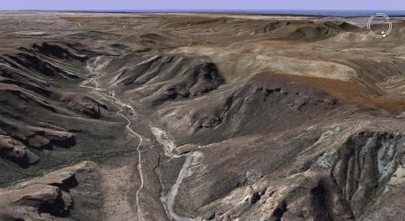
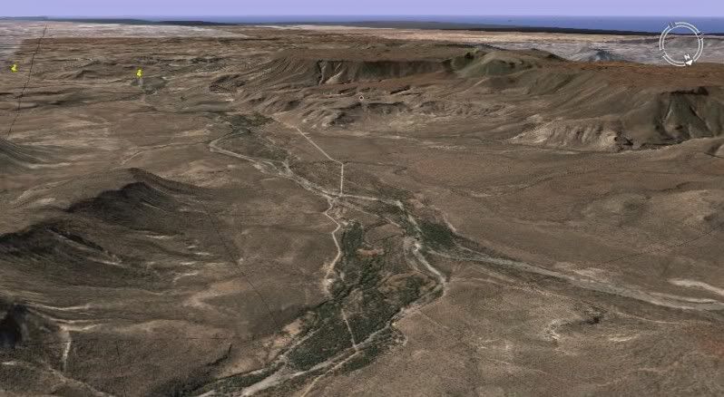
That route was a Camino Real used by the Spaniards and Indians in mission times...
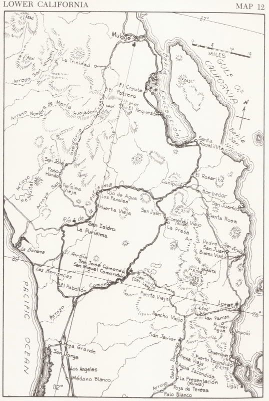
Shown as a trail in Gulick's 1962 map
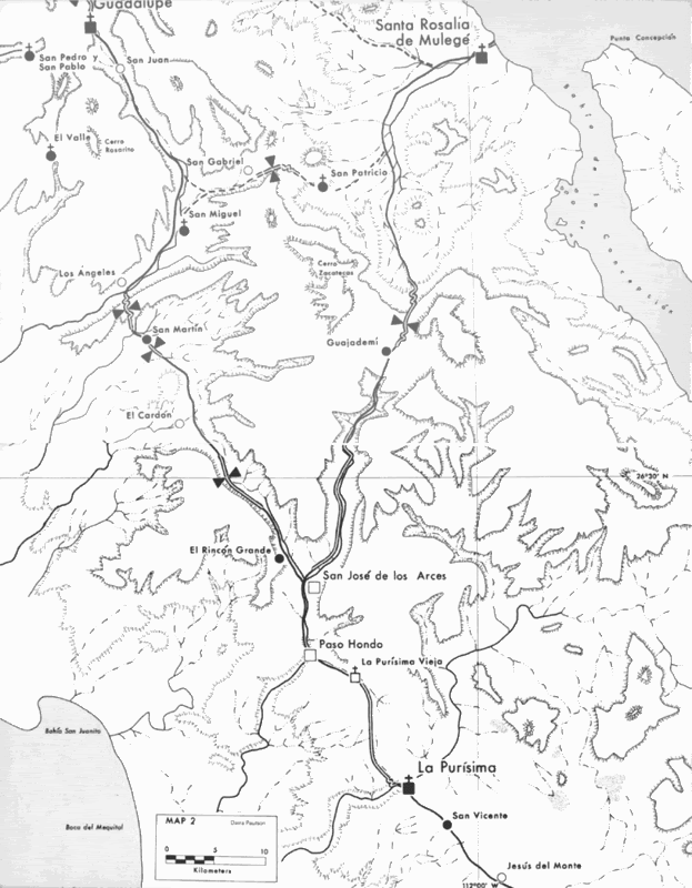
The Camino Real routes in Crosby's 1977 map
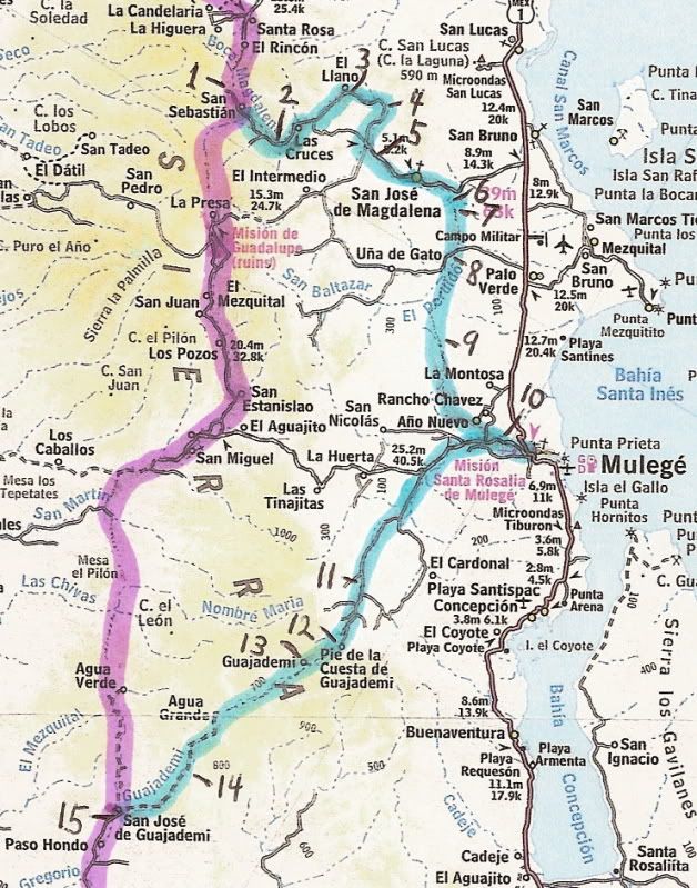
Following the Camino Real using Google Earth and marking the route on the 2003 Baja Almanac map.
Images from the points on the above map (10-15):
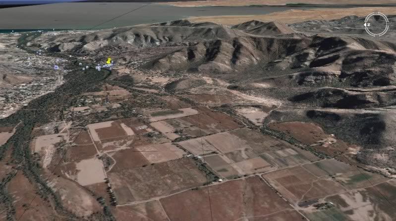
10
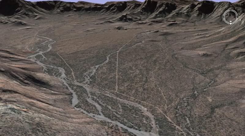
11
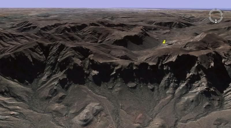
12
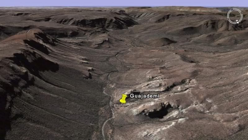
13
14
15
|
|
|
Blair
Junior Nomad

Posts: 63
Registered: 5-19-2010
Location: El Cajon Ca
Member Is Offline
Mood: Getting ready to go again
|
|
Thanks David, very, very interesting. Gregorio Trail? Very intriguing area. And Kurtg, I can see the cuesta you are referring to at the end of the
first canyon S of Mulege. Looks like quite a climb. We will be riding between Mulege and La Purisma the week of April 15 and are trying to finalize
our planned route. Something tells me if we try this we should allow plenty of time but it may be worth it.
Also Mulegena, thanks. Any info your hubby can pass along is appreciated!
|
|
|
David K
Honored Nomad
        
Posts: 65453
Registered: 8-30-2002
Location: San Diego County
Member Is Offline
Mood: Have Baja Fever
|
|
| Quote: | Originally posted by Blair
Thanks David, very, very interesting. Gregorio Trail? Very intriguing area. |
It looks like that at first glance... but the trail is along Arroyo San Gregorio... and the word TRAIL is seperate. It is the 'EL CAMINO REAL' between
La Purisima and MULEGE if you want to add a name to it.
See if you can take any photos if you see any of the mission trail work that hasn't been bulldozed over by modern road builders. Thanks!
|
|
|
motoged
Elite Nomad
     
Posts: 6481
Registered: 7-31-2006
Location: Kamloops, BC
Member Is Offline
Mood: Gettin' Better
|
|
Yes , it is manageable on dirt bikes....six buddies did it a year ago with no complaints....(one on a KLR  ) )
Don't believe everything you think....
|
|
|
KurtG
Super Nomad
   
Posts: 1211
Registered: 1-27-2004
Location: California Central Coast
Member Is Offline
Mood: Press On Regardless!!
|
|
| Quote: | Originally posted by motoged
Yes , it is manageable on dirt bikes....six buddies did it a year ago with no complaints....(one on a KLR  ) ) |
I was told that a year ago it was pretty good but some Spring & Summer rains had a bad effect. There were some nasty uphill rocky washouts that
my local friends said had not been there earlier in the year. Only takes one little storm back there in the hills to change everything. I would like
to hear from anyone who has gone through there on a bike in the past 6 months.
|
|
|
Mulegena
Super Nomad
   
Posts: 2412
Registered: 11-7-2006
Member Is Offline
|
|
Just chatted with my bro-in-law and showed him this thread.
He re-confirmed his initial report, specifically that the grade up out of Mulege is pretty intense, but do-able in a 4x4 car.
However, his information is historical rather than current, so with that in mind my husband and I are heading to La Purisima tomorrow. We'll probably
go in the "normal" route south Mex.1 to just beyond the bottom of the bay and turn west.
We'll enquire of the locals while we're there, and may possibly travel back to Mulege on the Guajademi route if we're feeling really adventurous.
Will let ya' know.
"Raise your words, not your voice. It's rain that grows flowers, not thunder." ~Rumi
"It's the mark of an educated mind to be able to entertain a thought without accepting it." ~ Aristotle
|
|
|
Blair
Junior Nomad

Posts: 63
Registered: 5-19-2010
Location: El Cajon Ca
Member Is Offline
Mood: Getting ready to go again
|
|
Wow thanks everyone for all the excellent info. I get this funny feeling that that route may not be a walk in the park, which even makes it more
interesting. Mulegena, any recent local info you can get in La Purisma would be very appreciated.
I love this stuff. Thanks again!
|
|
|
David K
Honored Nomad
        
Posts: 65453
Registered: 8-30-2002
Location: San Diego County
Member Is Offline
Mood: Have Baja Fever
|
|
Hey, we expect a good trip report with photos when you get back!!!  
|
|
|
Blair
Junior Nomad

Posts: 63
Registered: 5-19-2010
Location: El Cajon Ca
Member Is Offline
Mood: Getting ready to go again
|
|
That I will do David!
|
|
|
Mulegena
Super Nomad
   
Posts: 2412
Registered: 11-7-2006
Member Is Offline
|
|
We just got back... but where were we?
I need David's help here, please.
We went to La Purisima yesterday, visited the relatives and got the "Yes, you can go that way to Mulege (north through Paso Hondo) but why would you
want to?" questions from everybody.
Well we went, and we saw, and it was absolutely gorgeous country... but I think we got lost. Maybe.
We went through Paso Hondo and came to a Y- intersection "El Llano" or "Guajademi". A rancher told us not to take the Guajademi road but to head for
El Llano to get to Mulege.
We did. It was a really rough road of about 65 miles total from La Purisima to Mulege. Absolutely jaw-dropping gorgeous country and a glimpse of Baja
backcountry that folks just don't usually see,
but... where were we?
David???
"Raise your words, not your voice. It's rain that grows flowers, not thunder." ~Rumi
"It's the mark of an educated mind to be able to entertain a thought without accepting it." ~ Aristotle
|
|
|
David K
Honored Nomad
        
Posts: 65453
Registered: 8-30-2002
Location: San Diego County
Member Is Offline
Mood: Have Baja Fever
|
|
| Quote: | Originally posted by Mulegena
I need David's help here, please.
We went to La Purisima yesterday, visited the relatives and got the "Yes, you can go that way to Mulege (north through Paso Hondo) but why would you
want to?" questions from everybody.
Well we went, and we saw, and it was absolutely gorgeous country... but I think we got lost. Maybe.
We went through Paso Hondo and came to a Y- intersection "El Llano" or "Guajademi". A rancher told us not to take the Guajademi road but to head for
El Llano to get to Mulege.
We did. It was a really rough road of about 65 miles total from La Purisima to Mulege. Absolutely jaw-dropping gorgeous country and a glimpse of Baja
backcountry that folks just don't usually see,
but... where were we?
David??? |
YIKES! Well, if you don't know then... lol! EL LLANO is up and west of SAN JOSE DE MAGDALENA... But, that isn't on any road from La Purisima to
Mulege... so a different El Llano...
How did you arrive into Mulege, from what direction, what road... ?? Did you turn back at Paso Hondo... or continue driving north towards Mulege...
The only road/ pass is through Guajademi. Other routes west from Mulege pass San Miguel and come out north of San Juanico (Scorpion Bay) or pass
Mision Guadalupe and on to the Pacific south of San Ignacio.
|
|
|
KurtG
Super Nomad
   
Posts: 1211
Registered: 1-27-2004
Location: California Central Coast
Member Is Offline
Mood: Press On Regardless!!
|
|
| Quote: | Originally posted by Mulegena
I need David's help here, please.
We went to La Purisima yesterday, visited the relatives and got the "Yes, you can go that way to Mulege (north through Paso Hondo) but why would you
want to?" questions from everybody.
Well we went, and we saw, and it was absolutely gorgeous country... but I think we got lost. Maybe.
We went through Paso Hondo and came to a Y- intersection "El Llano" or "Guajademi". A rancher told us not to take the Guajademi road but to head for
El Llano to get to Mulege.
We did. It was a really rough road of about 65 miles total from La Purisima to Mulege. Absolutely jaw-dropping gorgeous country and a glimpse of Baja
backcountry that folks just don't usually see,
but... where were we?
David??? |
You were on the road that Blair asked about and to which GED and I referred. Several years ago before it went all the way through I followed it to
its end just above El Llano and yes the scenery is spectacular. In about two weeks we will try to retrace your route all the way through from the La
Purisima end and will take GPS readings and photos along the way. What kind of vehicle were you driving?
David, that road isn't on any of the maps that I am aware of.
Kurt
|
|
|
David K
Honored Nomad
        
Posts: 65453
Registered: 8-30-2002
Location: San Diego County
Member Is Offline
Mood: Have Baja Fever
|
|
Guajademi road is what you and Ged are describing... but Mulegena says the El Llano road is different (or was it)? I see no other route from Paso
Hondo to Mulege... It is the route the padres took!
|
|
|
chuckie
Elite Nomad
     
Posts: 6082
Registered: 2-20-2012
Location: Kansas Prairies
Member Is Offline
Mood: Weary
|
|
I think that is the road that a couple of my neighbors were on last week, on quads...They went to within sight of the coast from Mulege and didnt
think it was so bad....Maybe it was a different road, but I dont think so..Out past the icehouse and bear left..looks like it to me..
|
|
|
David K
Honored Nomad
        
Posts: 65453
Registered: 8-30-2002
Location: San Diego County
Member Is Offline
Mood: Have Baja Fever
|
|
The 2003 and 2009 Baja Almanac shows the road, but as a 'trail' between Agua Grande and Pie de la Cuesta de Guajademi... Other roads I have driven my
Toyota on have also been shown as 'trails' in the Almanac.
I still do not see a 'El Llano' along the route???
It is the highlighted route of the EL CAMINO REAL south from Mulege:

[Edited on 3-4-2012 by David K]
|
|
|
Mulegena
Super Nomad
   
Posts: 2412
Registered: 11-7-2006
Member Is Offline
|
|
Studied the maps thoroughly...
| Quote: | Originally posted by David K
| Quote: | Originally posted by Mulegena
It was... about 65 miles total from La Purisima to Mulege. Absolutely jaw-dropping gorgeous country and a glimpse of Baja backcountry that folks just
don't usually see... |
EL LLANO is up and west of SAN JOSE DE MAGDALENA... But, that isn't on any road from La Purisima to Mulege... so a different El Llano...
How did you arrive into Mulege, from what direction, what road... ?? Did you turn back at Paso Hondo... or continue driving north towards Mulege...
The only road/ pass is through Guajademi. Other routes west from Mulege pass San Miguel and come out north of San Juanico (Scorpion Bay) or pass
Mision Guadalupe and on to the Pacific south of San Ignacio. |
Thanks for responding, David, and a big thanks
for the detailed maps which I've studied and re-studied.
It appears we were on the correct road.
To clarify, remember I'm describing the journey south-to-north, La Purisima to Mulege: Coming out of Paso Hondo we did take the left fork
signed "El Llano" after turning around from Guajademi (which is just east of the main road and isn't a town-proper but a collection of isolated
sheep ranches, btw).
We climbed up onto a high plateau and I thought we'd reached Tibet.
Then we came to a Z-track, very serious percentage, down-grade which opened up onto a high plateau which had about 5-6 dirt-depressions
(tajos/re-pressas) for collecting seasonal rain. Slowly down, cross through the flat valley, then another Z-track up to the plateau on the other side.
Then through a ranch gate and down a big mountain.
Went through another ranch gate and passed two signs to "Rancho El Llanito" and another hour or so to come into the south-west Mulege river-wash area.
The sign to Rancho El Trinidad and the cave paintings was on our left and we came into town on Ice House Road.
So, yes, the road from Mulege to La Purisima via Guajademi is passable and even machine-graded where it can be. Where its not graded the road
is steep and large rocks.
We got through easily in our 1988 Chevy s10 4x4 pickup. I took lots of photos, and I'd love to do a trip report on a separate thread.
"Raise your words, not your voice. It's rain that grows flowers, not thunder." ~Rumi
"It's the mark of an educated mind to be able to entertain a thought without accepting it." ~ Aristotle
|
|
|
| Pages:
1
2
3
4 |

