| Pages:
1
2 |
evanthebruin
Newbie
Posts: 4
Registered: 7-11-2012
Member Is Offline
|
|
4wd route from Coco's/Calamuje to BOLA
Hi all. First post. I've heard about and read rumors of a challenging 4wd route from Calamuje Road that goes over Sierra la Asamblea to BOLA. I've
read some posts about Salsipuedes canyon, the DC-3, ranch gates, etc. but I haven't found any reports of a recent crossing of this area. Has anybody
here gone from Coco's to BOLA without getting near Highway 1? Think it's possible? Thanks for the help. Reading old threads on this site has learned
me a a lot of stuff. I appreciate the info!
|
|
|
motoged
Elite Nomad

Posts: 6481
Registered: 7-31-2006
Location: Kamloops, BC
Member Is Offline
Mood: Gettin' Better
|
|
I have done it on a dirt bike several years ago....not sure a 4 wheel can make all of it... I think it is called The Mine Trail in Lizard Lady's info
kit.... (Calamajue Canyon Ride - North).
She cautions: "ATV/4-wheels: be prepared for some intense soft sand and possibilities of high-centering" but this is mostly for the section south of
Cal wash when approaching from El Crucero...
My memory of the single track is rocks/shale, the usual sand and cactus....I rode it from ssouth end of BoLA down to Calamajue Rd where the trail
comes out east of Coco's and fairly close to the road south to the wash from Cal Rd.
Send us pics 
Don't believe everything you think....
|
|
|
David K
Honored Nomad
Posts: 65565
Registered: 8-30-2002
Location: San Diego County
Member Is Offline
Mood: Have Baja Fever
|
|
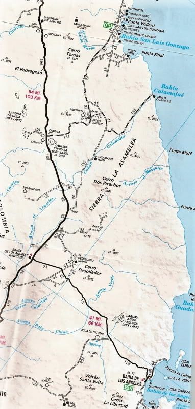
Kacey's Mine Route is between Pta. Final and Coco's. No other route south besides Calamajue and Mex. 5.
|
|
|
Ken Cooke
Elite Nomad
Posts: 8971
Registered: 2-9-2004
Location: Riverside, CA
Member Is Offline
Mood: Pole Line Road postponed due to injury
|
|
Baja Grande - Coco's to Calamajue to Hwy 1
I attempted this with several 4WD vehicles, but the route we took from Coco's Corner simply split from the road leading to Hwy 5 and took us around a
mountain to a point south dumping us out at Hwy 1.
On the other side of this green mountain lies the dry, Valle de Coco - where Coco's Corner is located.

Water flows along this canyon throughout the year, which ran as much as 4 feet deep in sections.


Closing in on Hwy 1

Be sure to carry a trust-worthy spare tire (or two).


|
|
|
evanthebruin
Newbie
Posts: 4
Registered: 7-11-2012
Member Is Offline
|
|
Ken,
Those pictures look like the narrow western part of calamuje wash. I went through there 11/2010. That might be the route I end up taking again.
David, if I understand you correctly, there simply isn't one. Either way, I'll have to draw something up in GE to better explain what I'm trying to
do.
|
|
|
larryC
Super Nomad
Posts: 1499
Registered: 8-11-2008
Location: BoLA
Member Is Offline
|
|
I think I understand what you are trying to do and I don't know of a trail that does that. From Cocos the road will put you onto mex 1 at about km
263, from there you can drive south to km 270 and then turn left back up into the hills to the top of Salsipuedes canyon. Before you get up that far
there is a trail off to the right that will eventually put you through Desengano and on towards the old La Luz mine. From there you can head towards
bola coming out on the paved road around km 20 or so. Its a fun route you'll like it.
Larry
Off grid, 12-190 watt evergreen solar panels on solar trackers, 2-3648 stacked Outback inverters, 610ah LiFePo4 48v battery bank, FM 60 and MX60
Outback charge controllers, X-240 Outback transformer for 240v from inverters, 6500 watt Kubota diesel generator.
|
|
|
motoged
Elite Nomad
Posts: 6481
Registered: 7-31-2006
Location: Kamloops, BC
Member Is Offline
Mood: Gettin' Better
|
|
David and I seem to be the only folks here understanding the question and providing the correct answer. 
The rest of you are looking for a road and and that is NOT the question....(Geez....it's hard to say I agree w/DK !!!) 
Don't believe everything you think....
|
|
|
David K
Honored Nomad
Posts: 65565
Registered: 8-30-2002
Location: San Diego County
Member Is Offline
Mood: Have Baja Fever
|
|
| Quote: | Originally posted by evanthebruin
Ken,
Those pictures look like the narrow western part of calamuje wash. I went through there 11/2010. That might be the route I end up taking again.
David, if I understand you correctly, there simply isn't one. Either way, I'll have to draw something up in GE to better explain what I'm trying to
do. |
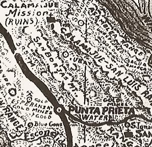
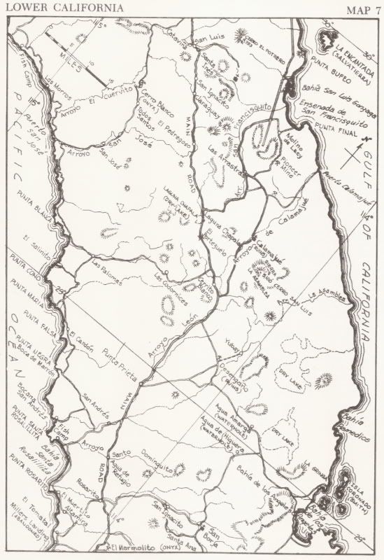
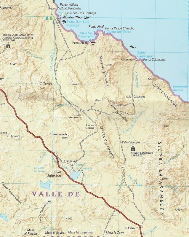
For a 4WD, correct... Mountains and canyons are between Gonzaga and L.A. Bay. So, from Gonzaga south you have the dirt highway (Mex. 5) or the old
original gulf route south of the 1960's which went past the Calamajue mission ruins (they are on the left side of the arroyo, up a short side road you
take after you drop into the arroyo, heading southbound).
The road is in the 'river' as seen on Ken's photos. However, BajaTripper just went that way a couple weeks ago and said it was a piece of cake, and no
4ft. deep holes... Of course he was in a Toyota... 
There are roads that go to the coast between Gonzaga and L.A. Bay... Puerto Calamajue, an un-mapped road to the coast a few miles south of Pto.
Calamajue and then coming north from the dry lake along the L.A. Bay highway are roads to Los Candeleros and Bahia Guadalupe (Remedios).
Some maps old and new:
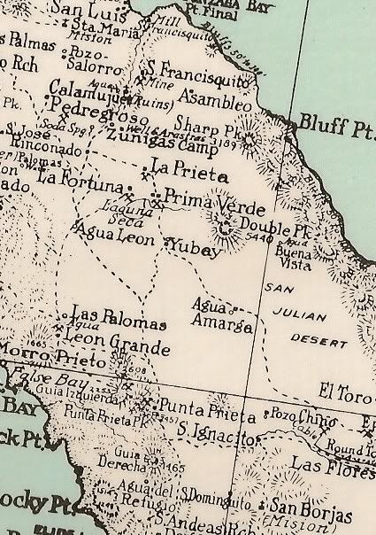
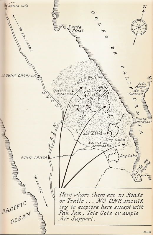
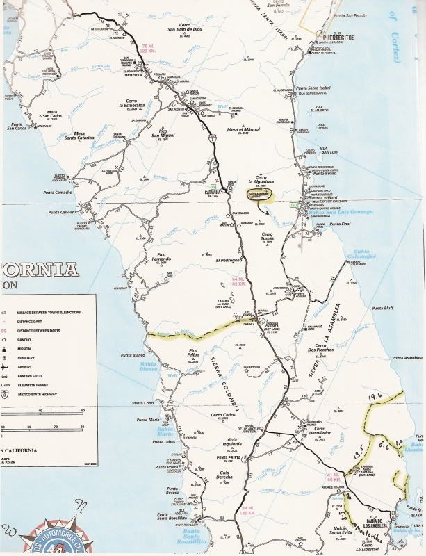
Now, there is a motorcycle route created by Bill Nichols that can be ridden to L.A. Bay without using the paved roads... Outlined in Kacey Smith's
Baja GPS guide Volume II, I believe.
[Edited on 7-12-2012 by David K]
|
|
|
Sweetwater
Senior Nomad
Posts: 915
Registered: 11-26-2010
Member Is Offline
Mood: chilly today hot tomale
|
|
| Quote: | Originally posted by motoged
I have done it on a dirt bike several years ago....not sure a 4 wheel can make all of it... I think it is called The Mine Trail in Lizard Lady's info
kit.... (Calamajue Canyon Ride - North).
She cautions: "ATV/4-wheels: be prepared for some intense soft sand and possibilities of high-centering" but this is mostly for the section south of
Cal wash when approaching from El Crucero...
My memory of the single track is rocks/shale, the usual sand and cactus....I rode it from ssouth end of BoLA down to Calamajue Rd where the trail
comes out east of Coco's and fairly close to the road south to the wash from Cal Rd.
Send us pics |
How about your pics Jed? It sounds like you rode a route from south to north?
Everbody\'s preachin\' at me that we all wanna git to heaven, trouble is, nobody wants to die to git there.-BB King
Reality is what does not go away when you stop believing in it. -Philip K Dick
Nothing is worse than active ignorance. Johann Wolfgang von Goethe(1749-1832, German writer, artist and politician)
When choosing between two evils, I always like to try the one I\'ve never tried before. - Mae West
Experience is what keeps a man who makes the same mistake twice from admitting it the third time around.
|
|
|
TMW
Select Nomad
Posts: 10659
Registered: 9-1-2003
Location: Bakersfield, CA
Member Is Offline
|
|
Kacey's ride is in volume one but it gets on the pavement 22 miles from LA Bay. I think she has mentioned that Bill Nichols' did or was doing a trail
to La Bay but I don't think it has been published anywhere except if you were riding with him.
|
|
|
David K
Honored Nomad
Posts: 65565
Registered: 8-30-2002
Location: San Diego County
Member Is Offline
Mood: Have Baja Fever
|
|
| Quote: | Originally posted by TW
Kacey's ride is in volume one but it gets on the pavement 22 miles from LA Bay. I think she has mentioned that Bill Nichols' did or was doing a trail
to La Bay but I don't think it has been published anywhere except if you were riding with him. |
Yes, the mine road is in Vol. 1, but ths Bill Nichols tracks are in Vol. 2. I only have 1, so not sure of which ones are included in 2, besides the
Puertecitos west to Hwy. 1 track.
|
|
|
motoged
Elite Nomad
Posts: 6481
Registered: 7-31-2006
Location: Kamloops, BC
Member Is Offline
Mood: Gettin' Better
|
|
I have no pics....but I must stand corrected on one point....the Mine Trail did not start at its north end from BoLA...it was south out from Gonzaga
and approached Calamajue Rd east of Coco's Corner....Sorry for my momentary geographical brain fart 
Thanks for the maps David 
Don't believe everything you think....
|
|
|
Sweetwater
Senior Nomad
Posts: 915
Registered: 11-26-2010
Member Is Offline
Mood: chilly today hot tomale
|
|
OK, I've ridden Calume Wash on my moto and could not find the connection to BOLA without hitting pavement.....it would be great to see that section of
coast line from a boat.....any of the fishing guys got photos?
Everbody\'s preachin\' at me that we all wanna git to heaven, trouble is, nobody wants to die to git there.-BB King
Reality is what does not go away when you stop believing in it. -Philip K Dick
Nothing is worse than active ignorance. Johann Wolfgang von Goethe(1749-1832, German writer, artist and politician)
When choosing between two evils, I always like to try the one I\'ve never tried before. - Mae West
Experience is what keeps a man who makes the same mistake twice from admitting it the third time around.
|
|
|
David K
Honored Nomad
Posts: 65565
Registered: 8-30-2002
Location: San Diego County
Member Is Offline
Mood: Have Baja Fever
|
|
| Quote: | Originally posted by Sweetwater
OK, I've ridden Calume Wash on my moto and could not find the connection to BOLA without hitting pavement.....it would be great to see that section of
coast line from a boat.....any of the fishing guys got photos? |
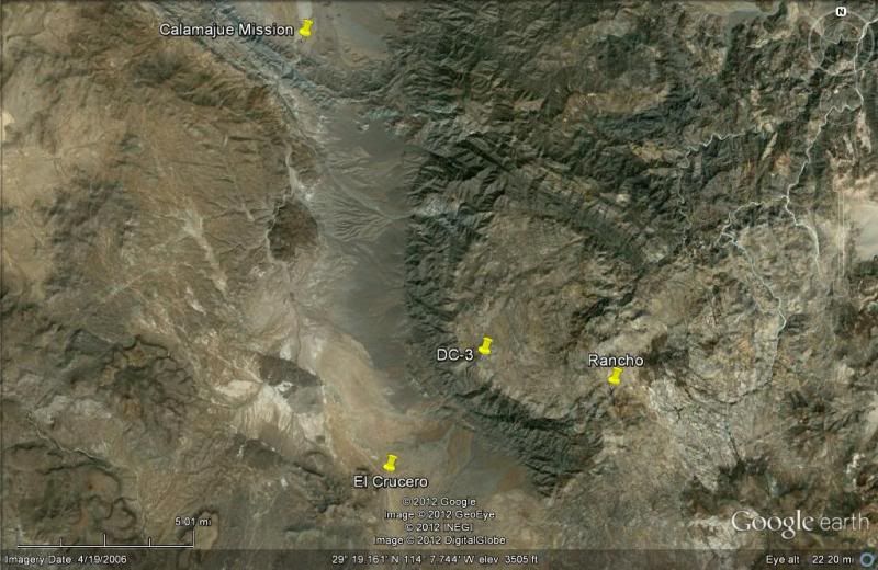
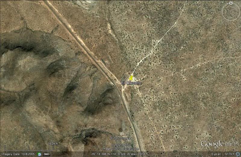
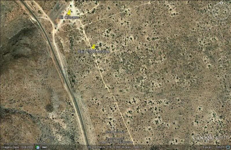
CALAMAJUE SOUTH:
When you come to Hwy. 1 at El Crucero, take the left fork about 300 meters/ yards before the highway... this is the Baja 1000 course that parallels
Hwy. 1 until it reaches the old L.A. Bay road (via Desengaño), where you turn left for L.A. Bay. You reach the L.A. Bay highway in Arroyo Yubay (that
giant dip)... then get on the pavement for the last 30 miles to L.A. Bay... Or, get more creative and find the older road which is parallel to the new
post-1974 one.
|
|
|
motoged
Elite Nomad
Posts: 6481
Registered: 7-31-2006
Location: Kamloops, BC
Member Is Offline
Mood: Gettin' Better
|
|
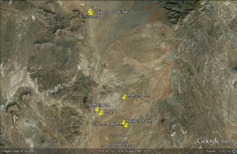
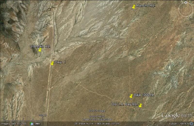
SW,
Once you come out of the Cal wash heading south, you come close to Hwy #1 where the barbwire fence is as well as a wrecked car or two. If you do not
get on Hwy 1 at that point, veer a bit to your left (east) and a well established whooped out sand road (old Baja 1000) that continues south....you
will then have options that will either be more eastwards (old mine/ranch?) and come out on a single track called Window Rock Trail by Lizard Lady
(Kacey Smith) that takes you out to BoLA closer to town than the other track does track does (which comes out onto BoLA hiway at about KM 11 from Hwy
!)
Window Rock Trail:
http://www.youtube.com/watch?v=DpQmWR3qK_c
Or....just Google "Window Rock Trail Baja" and see a bunch of helcam vids
Don't believe everything you think....
|
|
|
David K
Honored Nomad
Posts: 65565
Registered: 8-30-2002
Location: San Diego County
Member Is Offline
Mood: Have Baja Fever
|
|
Have a LOOK!

|
|
|
TMW
Select Nomad
Posts: 10659
Registered: 9-1-2003
Location: Bakersfield, CA
Member Is Offline
|
|
Kaceys' volume 2 has the Bill Nichols' trail from Puertecitos to Cativina and San Quintin. The trail starts about 6 miles south of Puertecitos on the
old road. I understand it's a motorcycle trail only. Tim Morton told me he did not think an ATV could get thru one canyon like section because it was
so narrow. I've never riden it so I don't know. But a short wheel based vehicle can get thru the Turquesa mine road. I saw it done. Well a jeep may
not make it, you know.
|
|
|
bent-rim
Nomad
Posts: 294
Registered: 7-31-2007
Location: Marin County
Member Is Offline
Mood: Living la vida mota
|
|
| Quote: | This is the way we've gone for years on dirt bikes. Sometimes the canyon is wet and sometimes it is dry, but it always stinks. Ask Coco, he'll know.
CALAMAJUE SOUTH:
When you come to Hwy. 1 at El Crucero, take the left fork about 300 meters/ yards before the highway... this is the Baja 1000 course that parallels
Hwy. 1 until it reaches the old L.A. Bay road (via Desengaño), where you turn left for L.A. Bay. You reach the L.A. Bay highway in Arroyo Yubay (that
giant dip)... then get on the pavement for the last 30 miles to L.A. Bay... Or, get more creative and find the older road which is parallel to the new
post-1974 one. |
|
|
|
Ken Cooke
Elite Nomad
Posts: 8971
Registered: 2-9-2004
Location: Riverside, CA
Member Is Offline
Mood: Pole Line Road postponed due to injury
|
|
| Quote: | Originally posted by motoged
She cautions: "ATV/4-wheels: be prepared for some intense soft sand and possibilities of high-centering" but this is mostly for the section south of
Cal wash when approaching from El Crucero... |
Our Jeeps traveled that section without a hiccup. Even the (open differentialed) Toyota's with their plastic running boards and tire flaps didn't get
stuck.
Open Diff'ed Toyota entering Calamajue Wash (from Coco's Corner)


Jeep approaching 3'-4' deep section.

Toyota drivers sometimes prefer to Tread Lightly!
Sandy sections near El Crucero

This deep sand was nothing for the vehicles, whatsoever.
Our group made it!

|
|
|
Sweetwater
Senior Nomad
Posts: 915
Registered: 11-26-2010
Member Is Offline
Mood: chilly today hot tomale
|
|
Very nice thread...........thanks for the pics and maps and directions.........looks too easy in the 4x4's and I'm sure it will be more challenging on
a moto......that sand is really not that appealing.......
Everbody\'s preachin\' at me that we all wanna git to heaven, trouble is, nobody wants to die to git there.-BB King
Reality is what does not go away when you stop believing in it. -Philip K Dick
Nothing is worse than active ignorance. Johann Wolfgang von Goethe(1749-1832, German writer, artist and politician)
When choosing between two evils, I always like to try the one I\'ve never tried before. - Mae West
Experience is what keeps a man who makes the same mistake twice from admitting it the third time around.
|
|
|
| Pages:
1
2 |


