| Pages:
1
2 |
BajaRun
Nomad

Posts: 222
Registered: 2-25-2012
Member Is Offline
Mood: Just Cruisin'
|
|
Following the Pacific from El Rosario south
I would like to run along the pacific ocean south of El Rosario as far as possible (Destination Bahia Asuncion or Scorpion Bay). Looking at the Baja
Almanac it looks like the furthest point south is San Carlos. But to continue south it looks like we need to start heading inland north of San Carlos,
just south of Barrancos del Mar, to catch the intersecting road that would take us to Punta Canoas area. From there it looks like we can skirt the
coast to almost Guerrero Negro...
Im looking for advise for this route, how far is it possible to follow the Pacific Ocean south of El Rosario ? It needs to be 2 track because we are
in buggys.
I noticed that the Baja 1000 doesn't follow the Pacific south, but rather heads east to BOLA before continuing south...why does the course not
continue along the Pacific side ???
|
|
|
fudscrud
Nomad
Posts: 113
Registered: 6-8-2010
Member Is Offline
|
|
You have that right. Punta San Carlos is as far as you can get along the coast without going inland and back to Pta Canoas. It would be tough for a
man and his burro to get through there. Even us moto guys who are a pretty dedicated lot havn't cut a trail through there...yet.
|
|
|
David K
Honored Nomad
Posts: 65563
Registered: 8-30-2002
Location: San Diego County
Member Is Offline
Mood: Have Baja Fever
|
|
This has nothing to do with secret surfing points!
However, it does have to do with some great off roading into a cold, windy and foggy region (if summer)... Maybe nicer in the winter?
The Punta San Carlos road is a dead end, and there is an off road trac that goes form just north of there inland to the San Fernando copper mine area
and reaches Hwy. 1 at El Progreso.
However, to really stay on track if your goal is Asuncion with a dirt trek down the Pacific coast, stay on Hwy. 1 to near Guayaquil and take the fast
graded road to Santa Catarina (a ranching village) and either left at the major fork just ahead or right for Puerto Catarina, then south... The short
cut directly to Puerto Canoas and south is using the left branch.
The Baja 1000 HAS used the Pacific Seven Sisters road a few times... the first was in 1975.
The Squarecircle (Land Rover LR3) and I (Tacoma) did the run in 2007 and went on to Bahia Asuncion. Here is the web page of that trip, with maps and a
road log:
http://vivabaja.com/707
From my web page... note thie was 5 years ago, and road conditions change. The once smooth graded road between Santa Rosalillita and Punta Cono has
been reported to be not so smooth. The are also areas of Baja Dust (Moon dust, silt beds) in that area. Four wheel drive and a companion vehicle is
advised! Top off gas at El Rosario and bring extra cans if you cannot make the 200 miles to Villa Jesus Maria or 20 more miles to Guerrero Negro using
4WD for some of those miles.
We left El Rosario Sunday with Roy following along for the next part of our vacation: The nearly 200 rough miles parallel to the Pacific side of Baja.
Some of this remote road has been used for off road racing. First time was the 1975 Baja 1000.
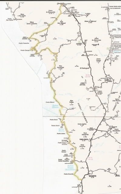
ROAD LOG: THE DISTANT PACIFIC
Road Log 194.7 miles from Hwy. 1 to Hwy.1
The route along the Pacific is a way one can experience a little of what it was like to drive the length of Baja before Highway 1 was constructed
between 1967 and 1974 (Dec. '73).
The route shown on the map is almost 200 miles and there are no services or fuel until Santa Rosalillita or beyond at Villa Jesus Maria.
Total (and partial) mileage shown from my Tacoma odometer. AAA map mileages for the same section of road were the same or very close to mine.
0.0 (0.0) Take the signed right turnoff to 'Santa Catarina (32 km)' 46.9 miles from El Rosario's Pemex. The road is between Km. 132 and 133. Just
ahead (on Hwy. 1) is the road left to Guayaquil.
This is a good, fast graded road for the first 30 or so miles and it is fun to drive through beautiful cactus gardens.
7.2 (7.2) Road in from left to San Agustin along the old route from El Marmol... where onyx blocks were trucked to the Pacific at Santa Catarina
Landing to be shipped north.
19.2 (12.0) pass through tree shaded Rancho Santa Catarina.
21.1 (1.9) Fork, left to Punta Canoas and right for Santa Catarina Landing... we go right. The road climbs to the the top of a ridge and then drops
down to the coastal plain. The original road used to haul onyx over can be seen to the north.
36.3 (15.2) Fork, we first take right fork and it goes 3.4 miles to fish camp 'Punta Blu'... dead end, so back to this fork and take left branch.
37.3 (1.0) Road left is the route south... ahead goes 1.0 mile to Santa
Catarina fish camp, on the beach.
38.1 (0.8) Turn left and head away from coast.
47.3 (9.2) Come to the Punta Canoas road which forked at Mile 21.1 above. Turn right.
51.3 (4.0) Road to left... we continued straight.
52.3 (1.0) Road to left... we continued straight.
55.2 (2.9) Junction... Ahead goes 1.1 miles to high, look out/ view point, above Punta Canoas... To continue south, turn left.
58.5 (3.3) Join with road heading south (probably coming from the roads that turned left at Mile 51.3 and 52.3).
62.0 (3.5) Puerto Canoas Fish Camp.
Reset odometer to 0.0 for the next section of the road log.
========================================
0.0 (0.0) Puerto Canoas Fish Camp.
We first travel across the arroyo valley to investigate a modern, large home/ building near the beach... then head east.
1.8 (1.8) Big house facing beach on south side of arroyo. Head east, as no road is seen going south, close to the beach.
The auto club map shows the road we are on and we make camp at Mile 8.0 at the base of a pointy hill... about where the mileage '13.9' is shown on the
AAA map.
The Baja Almanac only shows this road as a trail. Our first night camp is to the east of the word 'Mujeres' (an arroyo) on Almanac Map 17.
17.4 (15.6) Pass a pair of graves and come to a cross road at an abandoned ranch. This should be the road from Hwy. 1 near Cataviña going to Faro San
Jose. We turn right.
19.6 (2.2) Cross road, fenced entrance. Continue ahead.
21.5 (1.9) Join newer, graded road... continue ahead.
22.6 (1.1) Green school(?), fork to right.
33.1 (10.5) Road in from right, continue ahead.
35.5 (2.4) Fork, go right.
37.4 (1.9) Road to El Mirador to right, continue ahead.
39.6 (2.2) Arroyo San Jose fish camp.
We want to stay near to the coast, and find a poor 'Jeep' road that does just that. After 6 slow miles we near Bahia Corbin and drive out onto the
point on the north side of the bay for a lunch break. Finally, a beautiful looking beach... but a fish camp is there, too.
46.0 (6.4) Bahia Corbin, north end camping area on side road, just off coastal road.
Reset trip odometer to 0.0.
========================================
0.0 (0.0) Bahia Corbin. Return short distance to coastal road by fish camp and continue south.
8.8 (8.8) Arroyo La Pintada valley and road to east (to Laguna Chapala?).
10.4 (1.6) A second road going east which I am pretty sure is the unmapped road to Laguna Chapala on Hwy. 1.
16.0 (5.6) Road to coast at Bahia Blanco. We continue south.
The main road swings inland along Arroyo El Sauz, but we see a lesser dirt road cutting across the marsh (was dry) area staying nearer the coast and
take it. This is not shown on the AAA map or Almanac.
21.7 (5.7) Meet newly graded roadbed on south side of Arroyo El Sauz. This soon follows the 'poor' road location shown on the Almanac and AAA map.
29.3 (7.6) After lots of silt on the graded roadbed we come to the north-south (now graded) road between Cordonices and Punta Maria. We turn right on
the fast road, or better called 'dirt highway'.
34.5 (5.2) Road to right goes to Punta Cono. We continue south.
42.2 (7.7) Bahia Maria beach, near Punta el Diablo
43.0 (0.8) El Cardon ranch.
46.1 (3.1) Road to beach 0.4 mi., just south of Punta Lobos.
We are pooped from so much hard driving and want to make camp, so we go to the beach for a look.
We drive down the beach to find a camp site in the Valle los Ojitos dunes. A sea lion (lobo) is on the shore... photos.
========================================
0.0 (0.0) Beach road (Punta Lobos/ Valle los Ojitos)
6.8 (6.8) Road west to El Marron fish camp (near Punta Prieta/ Punta Negra). Road (or dirt highway here) heads away from the coast around the Sierra
San Andres.
17.0 (10.2) Cross Arroyo San Andres
17.2 (0.2) Road west signed to '3 Alejandras' (Puerto San Andres).
21.1 (3.9) Come to PAVED Santa Rosalillita highway, turn right for the coast. (Hwy. 1 is about 8 miles to the left)
22.1 (1.0) FORK, Escalera Nautica Harbor is 1.2 miles to right. Straight ahead goes to:
22.5 (0.4) Santa Rosalillita village on the beach. Gas and supplies available.
Reset trip odometer to 0.0 for the final section of this coastal road log to Hwy. 1 via Punta Rosarito.
========================================
0.0 (0.0) Santa Rosalillita. Take street parallel to the coast south... road soon turns inland and crosses Arroyo Santo Dominguito, eventually
returning nearer the beach.
This is a slow, rough road and is only advisable if you seek a wide, sand beach that stretches for miles in both directions.
11.0 (11.0) Road to west to coast at Punta Rosarito.
15.4 (4.4) Road has been following a rocky shore for a few miles and now leaves the coast.
18.1 (2.7) Highway 1 at Km. 63 (63 kilometers south of the Bahia de los Angeles junction).
Nuevo Rosarito is almost 7 miles north and Villa Jesus Maria (Pemex station) is 19.8 miles south.
Summary: The 'distant Pacific' is a combination of remote areas, rough and
good roads, rocky and sandy beaches, commercial fishing camps as well as unpopulated areas.
The northern half coast (Santa Catarina, Canoas, San Jose) is an area so unappealing and little to offer that I would probably not return. The inland
sections (in the sunshine), had some beautiful desert scenes, but the overcast coastline wasn't appealing considering the distance and lack of
services.
The southern half had some fine looking beaches as well as the 'ugly' fish camps, but the water temperature is so cold that I wouldn't be going there
often, if ever again. The Sea of Cortez spoils me...
Another note... the Mexican government has built a paved highway to the coast at Santa Rosalillita and a good dirt highway north of Punta Cono with
unfinished construction to Bahia Blanca. THIS AREA is no secret, and anywhere a standard auto can get to it won't be long before problems follow. It
is BAD ROADS that filter out the bad people, not road logs or maps.
This Pacific coast road has been logged and mapped since the 1950's (Lower California Guidebook, Offbeat Baja, Baja Adventure Book, AAA map and guide,
etc.). If I can find unpopulated beaches in 2007, after 50 years of maps and guides... then I can hardly blame any author if development comes!
Nope, it will be the paved and graded dirt highways that will change the area, as it has everywhere else in Baja they were built.
[Edited on 11-1-2012 by David K]
|
|
|
TMW
Select Nomad
Posts: 10659
Registered: 9-1-2003
Location: Bakersfield, CA
Member Is Offline
|
|
| Quote: | Originally posted by BajaRun
I noticed that the Baja 1000 doesn't follow the Pacific south, but rather heads east to BOLA before continuing south...why does the course not
continue along the Pacific side ??? |
SCORE tends to use the same routes I think because they can deal with the same people. The last time they ran down the pacific coast to at least Santa
Rosalillita was 1986, I think. They tried to run down the coast in 2003 and turn east toward Chapala but the silt beds were so bad near the ocean from
pre-running they turned the course toward Catavina and used the hwy to Chapala.
|
|
|
David K
Honored Nomad
Posts: 65563
Registered: 8-30-2002
Location: San Diego County
Member Is Offline
Mood: Have Baja Fever
|
|
That last time was shown in Dust to Glory (2004 Baja 1000 I think?)
|
|
|
BajaRun
Nomad
Posts: 222
Registered: 2-25-2012
Member Is Offline
Mood: Just Cruisin'
|
|
DK, from El Rosario to the next Pemex for fuel is 250 miles accurate ? Any other fuel available ?
|
|
|
David K
Honored Nomad
Posts: 65563
Registered: 8-30-2002
Location: San Diego County
Member Is Offline
Mood: Have Baja Fever
|
|
| Quote: | Originally posted by BajaRun
DK, from El Rosario to the next Pemex for fuel is 250 miles accurate ? Any other fuel available ? |
VILLA JESÚS MARÍA is about 200 miles and if they are closed the state border is next 20 miles south then 4 more miles to GUERRERO NEGRO.
[Edited on 11-2-2012 by David K]
|
|
|
Pacifico
Super Nomad
Posts: 1299
Registered: 5-26-2008
Member Is Offline
|
|
Bajarun,
That is a tough stretch with little fuel. We have done the stretch from Santa Rosalillita north along the coast and came out in Catavina just north of
town.
Unless you are running a support truck with fuel, it would be tough. How big of a fuel cell do you have? I have only a 22 gallon and it gets close
sometimes. I would recommend a 32 or 35 gallon. Maybe go south from Catavina to Rosalillita?
Here is a trip we did a couple years ago:
http://forums.bajanomad.com/viewthread.php?tid=45239#pid5079...
Good luck and take lots of pics!
"Plan your life as if you are going to live forever. Live your life as if you are going to die tomorrow." - Carlos Fiesta
|
|
|
BajaRun
Nomad
Posts: 222
Registered: 2-25-2012
Member Is Offline
Mood: Just Cruisin'
|
|
32 gallon fuel cell for me. My range is 300-325 miles.. I should be good but Im not sure about some of the other vehicles. DK states he has no desire
to run this section again, spoiled by the cortez side, I resemble that but we want to take a different route south than we take back north, which will
be a route I have taken before...so this is the only option I know of that is not burning a whole lot of slab..suggestions accepted.
|
|
|
David K
Honored Nomad
Posts: 65563
Registered: 8-30-2002
Location: San Diego County
Member Is Offline
Mood: Have Baja Fever
|
|
Oh, I would do it again... you buy the gas, and I will join you! I love four wheeling in Baja... but my business has been way too slow to take as many
trips south as typical!
|
|
|
Ryan
Newbie
Posts: 21
Registered: 6-18-2009
Location: Costa Mesa / Campo Lopez
Member Is Offline
|
|
Would be a really fun trip in a buggy. Popular area with the moto tours. It's pretty scary when you think you are the only one on a road and 4 motos
come around a blind corner going 40mph 
Not the best route if you are looking for a speed run though...
|
|
|
BajaRun
Nomad
Posts: 222
Registered: 2-25-2012
Member Is Offline
Mood: Just Cruisin'
|
|
@Ryan, do the dirt bike tours start the day at the Old Mill and run down to GN to spend the nite ? That's our "Plan"..
|
|
|
willardguy
Elite Nomad
Posts: 6451
Registered: 9-19-2009
Member Is Offline
|
|
tell JB to invite taddy blazusiak along! 
|
|
|
motoged
Elite Nomad
Posts: 6481
Registered: 7-31-2006
Location: Kamloops, BC
Member Is Offline
Mood: Gettin' Better
|
|
Ahhhhh, DT Bushpilot and I will do it for beer, gas, and tacos.....Taddy is too busy mopping up the world enduro league

[Edited on 11-2-2012 by motoged]
Don't believe everything you think....
|
|
|
thebajarunner
Ultra Nomad
Posts: 3755
Registered: 9-8-2003
Location: Arizona....."Free at last from crumbling Cali
Member Is Offline
Mood: muy amable
|
|
Please post some road reports
If you make this run let us know how the road conditions are.
Would like to make the run out from Penjamo/Guaquil and/or from Catavina next June.
Will be taking a couple of 2 wheel drive pickups,
but have many years and miles of experience in the 2 wheel variety.
Just cannot make much progress in heavy sand.
So, give us some news.
por favor...
|
|
|
David K
Honored Nomad
Posts: 65563
Registered: 8-30-2002
Location: San Diego County
Member Is Offline
Mood: Have Baja Fever
|
|
Silt beds will be more of an issue than sand on the roads...
|
|
|
woody with a view
PITA Nomad
Posts: 15940
Registered: 11-8-2004
Location: Looking at the Coronado Islands
Member Is Offline
Mood: Everchangin'
|
|
and please leave the details of the supposed surf spots out of any report....

|
|
|
gnarlon
Newbie
Posts: 17
Registered: 11-3-2008
Member Is Offline
|
|
Poor Woody...
|
|
|
woody with a view
PITA Nomad
Posts: 15940
Registered: 11-8-2004
Location: Looking at the Coronado Islands
Member Is Offline
Mood: Everchangin'
|
|
not really.... i have more than you'd ever imagine, all thanks to King Neptune.
|
|
|
willardguy
Elite Nomad
Posts: 6451
Registered: 9-19-2009
Member Is Offline
|
|
riddle me this, is it possible to time it on a super low tide and just run down the beach for 25 miles between san carlos and punta canoas?
|
|
|
| Pages:
1
2 |