| Pages:
1
2 |
Hendo
Junior Nomad

Posts: 39
Registered: 9-2-2009
Location: Oregon
Member Is Offline
|
|
Marine GPS
Been searching around the internet looking for a marine GPS. New to the sport of knowing where I am. Would like to use the unit to report my
locations if in trouble. Already have a marine radio. Would like to use as a guide to find GPS coordinates. Having a hard time sorting through the
info and understanding what is really necessary. Rechargeable, handheld, affordable, sounds good. Any ideas?
|
|
|
bajaguy
Elite Nomad
Posts: 9247
Registered: 9-16-2003
Location: Carson City, NV/Ensenada - Baja Country Club
Member Is Offline
Mood: must be 5 O'clock somewhere in Baja
|
|
If you are looking for something to report an emergency on the water or on land, and get evacuated, look at SPOT
http://international.findmespot.com/
|
|
|
DavidT
Nomad
Posts: 494
Registered: 4-9-2005
Member Is Offline
|
|
http://www.bigwatersedge.com/bwevb/index.php
You'll find good info here. Some of these kayaks are set up with a full Nav package. Although I still haven't seen one with an electric drive &
autopilot.
David
Not one shred of evidence supports the notion that life is serious.
|
|
|
Islandbuilder
Senior Nomad
Posts: 555
Registered: 11-9-2011
Location: nob
Member Is Offline
Mood: bewildered
|
|
Hendo, what sort of vessel are you operating?
many choices from stand alone handheld units to integrated hard wired systems.
If it is critical to your safety, I would suggest some sort of redundancy, hard wired as a primary and hand helds as backups.
|
|
|
Pescador
Ultra Nomad
Posts: 3587
Registered: 10-17-2002
Location: Baja California Sur
Member Is Offline
|
|
I use my GPS to store locations and what are called waypoints, which in my case are fishing spots. I can use a "go to" to find the spot where my
coordinates are and I can return to home base. Most GPS leave a track which can be made permanent where you have some course that you use to navigate
a certain area. Most of the software programs that are used for navigation are innacurate in the Sea of Cortez, more accurate on the Pacific side
because of newer maps.
If I am out and the fog comes in, it is an easy matter to return on track or put in the home anchorage waypoint. With the news WAAS they are very
accurate and concise.
|
|
|
Hendo
Junior Nomad
Posts: 39
Registered: 9-2-2009
Location: Oregon
Member Is Offline
|
|
Islandbuilder: I'm in a 16' aluminum tiller style. I think I would like to start with a hand held. See how it goes.
I'm looking to perform the same task as Pescador has described. Just wondering if anyone has some advice as to good handhelds that will be easy to
use and accomplish those goals.
|
|
|
David K
Honored Nomad
Posts: 65563
Registered: 8-30-2002
Location: San Diego County
Member Is Offline
Mood: Have Baja Fever
|
|
The Spot unit is excellent as a way to let your friends know where you are and to send an SOS if needed. I am currently posting the location of Baja
adventure author Graham Mackintosh on Isla Angel de la Guarda, here on Nomad. Graham sends a signal every few days or anytime he moves to a new
location. Others, like the NatGeo guys or Mike Younghusband a couple years ago (walked to Cabo from Tecate with a burro to carry supplies, named
Don-Kay) set their Spot device to send a signal every hour (or ?) so you can follow their path. The signal GPS location is emailed out to who ever you
choose before your trip... and the SOS signal goes to the authorities.
See the maps or Google satellite locations of Graham in this thread: http://forums.bajanomad.com/viewthread.php?tid=65259
[Edited on 3-2-2013 by David K]
|
|
|
Alan
Super Nomad
Posts: 1631
Registered: 4-6-2005
Location: Yucaipa, CA/La Paz
Member Is Offline
|
|
As Pescador says... the ability to save a track is extremely valuable when navigating unfamiliar bays such as San Quintin or Mag Bay. In addition to
fishing waypoints I also mark hazardous rocks that even if they show on my e-charts may not be where the map shows them. The vessel you are using
this on I assume is a boat since you said you want to chase down "radio fish" (always an iffy proposition unless you have a reliable code group) and
difficult to do in a kayak. I would suggest starting with a mounted unit that includes a chartplotter and highly recommend a color unit as details
are so superior as compared to a monochrome unit.
In Memory of E-57
|
|
|
tripledigitken
Ultra Nomad
Posts: 4848
Registered: 9-27-2006
Member Is Offline
|
|
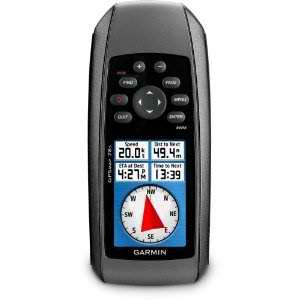
GPS Store
This is a good company to shop, research and buy from.
This is a handheld unit you might want to consider, very competively priced too.
http://www.thegpsstore.com/Garmin-GPSMAP-78-Color-Handheld-G...
|
|
|
Islandbuilder
Senior Nomad
Posts: 555
Registered: 11-9-2011
Location: nob
Member Is Offline
Mood: bewildered
|
|
| Quote: | Originally posted by Hendo
Islandbuilder: I'm in a 16' aluminum tiller style. I think I would like to start with a hand held. See how it goes.
I'm looking to perform the same task as Pescador has described. Just wondering if anyone has some advice as to good handhelds that will be easy to
use and accomplish those goals. |
Gotcha. I use a 17' inflatable as a skiff on the big boat, and use it to explore SE Alaska. In several areas we need to save our tracks so we can find
our way through tidal flats. As others have said, the ability to record a track is very comforting while navigating in lower unit eating shoals.
Especially when the water has the clarity of a milkshake as it often does in from of a glacier.
Garmin makes several good portable units, and there are some good small rail mounts that will allow you to keep your hands free.
The models, features and prices change regularly, so go see that they have that you like. I think that my GPS/plotter was about $400 and it has worked
well for the last 2 years.
The trick I use is to enter a tricky area for the first time in the spring (these outflow rivers change every year) on the lowest tide of a cycle, and
record that track. At low tide the channel is revealed, and I can follow the track at higher tides when water 6" and 600' deep both look exactly the
same.
|
|
|
chippy
Super Nomad
Posts: 1806
Registered: 2-2-2010
Member Is Offline
|
|
Great advice. I just bought a Furuno gp35 from them. They had the best selection and price.
|
|
|
MitchMan
Super Nomad
Posts: 1857
Registered: 3-9-2009
Member Is Offline
|
|
Google earth has a great sattelite map and will give you lat and lon anywhere you place the cursor on the map. Also, you can really magnify the map
with pretty good visual detail. You have to download an executable program...takes just a few minutes to do, if that.
I use it to write down lat lon for known fishing spots, landings and launch ramp locations. You can also put down tracks and it will tell you how
many feet the track is at sea level. You can even see your house and land mark buildings anywhere in Baja, specific roads. The map will tell you the
date of the satellite image as well. The imagery is so good, you can easily recognize most any spot that you have seen and then jot down its lat and
lon. Magic!
|
|
|
Hook
Elite Nomad
Posts: 9013
Registered: 3-13-2004
Location: Sonora
Member Is Offline
Mood: Inquisitive
|
|
I would think it would be rather frustrating to use a hand held GPS on a smallish tin boat as a real aid to navigation. Two inch screens and tightly
packed buttons would cause much of the frustration, especially while steering with one hand. But if you're only really looking for a device that can
show your lat/lon location in an emergency, go for it.
Otherwise, I'd consider looking at mounted models in the 4-5 inch screen size, IF a mounted model is possible on your boat. It may not be. A GPS unit
this size would also easily transfer to a larger boat, if that's in your future.
It's just rather difficult to follow TRACKS on screens as small as two inches, at least for my old eyes.
|
|
|
mulegemichael
Super Nomad
Posts: 2310
Registered: 12-24-2007
Location: sequim,wa. and mulege
Member Is Offline
Mood: up on step
|
|
think garmin; you can't lose.
dyslexia is never having to say you\'re yrros.
|
|
|
chuckie
Elite Nomad
Posts: 6082
Registered: 2-20-2012
Location: Kansas Prairies
Member Is Offline
Mood: Weary
|
|
I am using an OLD fixed mount GPS which has never failed me, with a handheld Garmin Etrex as back up. My advice is to buy as simple a unit as possible
which will do the basics you described. I see all kinds of folks who havnt the vaguest idea how to use many of the functions on their units. Mapping
on the sea of cortez is problematical, and you can see where you are going most of the time anyhow....Think simple..Etrex's can be bought on ebay for
around 100 bucks..I have 2
|
|
|
Frank
Senior Nomad
Posts: 861
Registered: 6-5-2005
Location: San Diego
Member Is Offline
Mood: Is it time to leave yet?
|
|
If you have a IPhone, Navionics has a app that works great even out of range of cell towers. Ive been as far as 80 out and it's was dead on with my
Raymarine chart plotter.
|
|
|
Pescador
Ultra Nomad
Posts: 3587
Registered: 10-17-2002
Location: Baja California Sur
Member Is Offline
|
|
For years I used a hand held Garmin E-trex which worked very well for tracks, waypoints, and locations. It did not have a map, and as far as the
small screen was concerned, it worked very well with a suction mount. In fact, I gave it to a good friend of mine who is a panguero and he continues
to use it today. In fact, he is doing well with all of my spots. 
There are some newer hand held Garmins that are loaded with lots of great equipment.
Try http://www.garmin.com
|
|
|
Pompano
Elite Nomad
Posts: 8194
Registered: 11-14-2004
Location: Bay of Conception and Up North
Member Is Offline
Mood: Optimistic
|
|
As another fan, I'd recommend going Garmin.
I have used this handheld gps everywhere in North America, including Baja inland and offshore, for many years. I've also taken it with me to Europe
and throughout the Pacific. It's a very reliable product made by one of the most respected companies in the gps business. I've met more inland &
offshore gps users owning Garmins than any other name brand.
Although not a huge capacity, it comes with about 8 megabytes of storage space, but that's enough for me..and I am quite active. Originally, I
carried this as a boat-spare but I soon found myself using it more than the high-priced Lowrance sonar/gps mounted in the boat. Screen on my Lowrance
is 10 inches...you can see the nice-sized screen on my handheld is easily read. That handheld Garmin stores up to 1000 waypoints (your favorite
places) and will get you home in dense fog and/or black nights safely, as it has done for me many times in many remote....and sometimes fuzzy...
places.
It's rugged. So easy to use, even this Baja caveman can use it. A huge plus for me is that it floats in the ocean and will survive a good dunking in
an icy river or your beer cooler. Not just a boat toy, I use mine for big cities, finding interstate exits, road trips, bistros, hunting, hiking,
cruising, pizza, and fishing. You can load it with a helluva variety of useful tools like sunset, sunrise times, tides, lights, bouys, beacons, and a
hunting-fishing calendar.
The bad news is ...Garmin discontinued this particular model. 

The good news is ...there's a new sheriff in town. Garmin GPSMap 7sc 2.6 inch Waterproof Marine GPS.
The moral of my story is...Go Garmin.
I do what the voices in my tackle box tell me.
|
|
|
rts551
Elite Nomad
Posts: 6700
Registered: 9-5-2003
Member Is Offline
|
|
another + for Garmin. Try the 60CSX or 76CSX. I use the 60csx on the ATV and in the boat. lots of capacity, but like all GPS's you need to buy
some Mexico/Baja mapping for the unit.
|
|
|
MitchMan
Super Nomad
Posts: 1857
Registered: 3-9-2009
Member Is Offline
|
|
I use an old hand held Garmin 75. Had it for nearly 20 years. Cost $500 USD, now you can get them on Ebay for $25 all day long. Works great, use it
on a small runabout and pangas when fishing. If you have a good compass and don't go out of the immediate area by that much, you don't need to have
the GPS on all the time, just when you are starting out, verifying current location from time to time and when moving from one spot to another or
going home for the day, otherwise, I turn it off and save on the battery...don't need it on all the time. Also, a 2.5 inch square display is plenty
big enough.
[Edited on 3-5-2013 by MitchMan]
|
|
|
| Pages:
1
2 |


