| Pages:
1
2 |
MexicoTed
Senior Nomad

Posts: 708
Registered: 8-2-2004
Member Is Offline
|
|
Poza de Escuadra
A couple friends and I are finally planning a trip to see Mision Santa Maria de Los Angeles near Catavina. One friend mentioned hiking to Poza de
Escuadra also. I know many Nomads have visited the mission, but how far is Poza de Escuadra from the mission?
Thanks,
Ted
|
|
|
brewer
Nomad
Posts: 419
Registered: 1-4-2011
Location: BCS
Member Is Offline
Mood: Grateful
|
|
We have a place on Gonzaga and want to do the trek to the mission ruins. Does anyone know how far you can get from the east close to it. Driving a
full size Dodge diesel.
Thanks for any info.
|
|
|
Barry A.
Select Nomad
Posts: 10007
Registered: 11-30-2003
Location: Redding, Northern CA
Member Is Offline
Mood: optimistic
|
|
Wow-----What a gorgous place to camp--------------great photos, guys.
Barry
|
|
|
David K
Honored Nomad
Posts: 65586
Registered: 8-30-2002
Location: San Diego County
Member Is Offline
Mood: Have Baja Fever
|
|
| Quote: | Originally posted by brewer
We have a place on Gonzaga and want to do the trek to the mission ruins. Does anyone know how far you can get from the east close to it. Driving a
full size Dodge diesel.
Thanks for any info. |
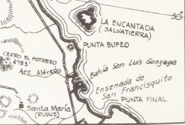
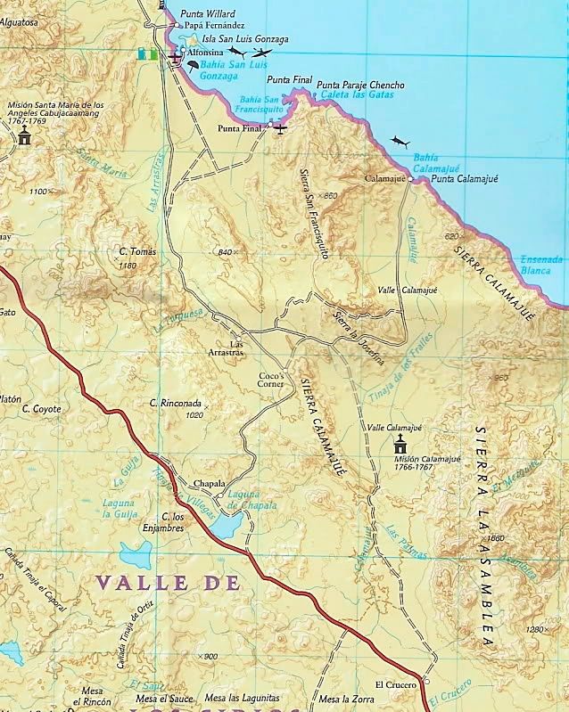
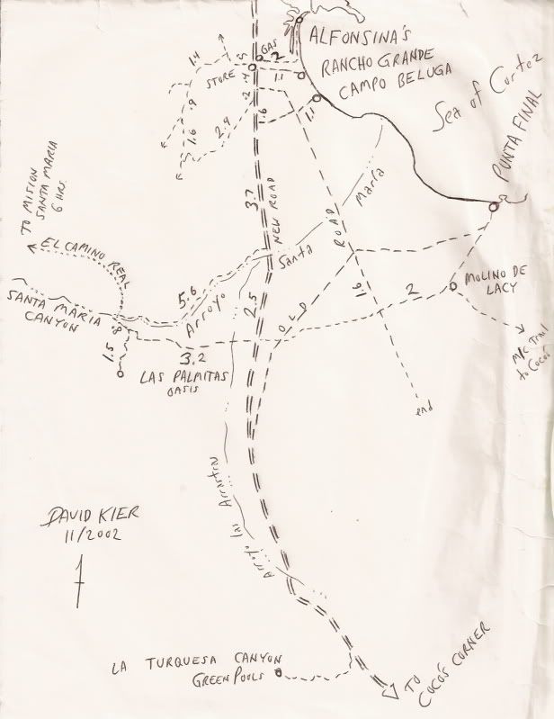
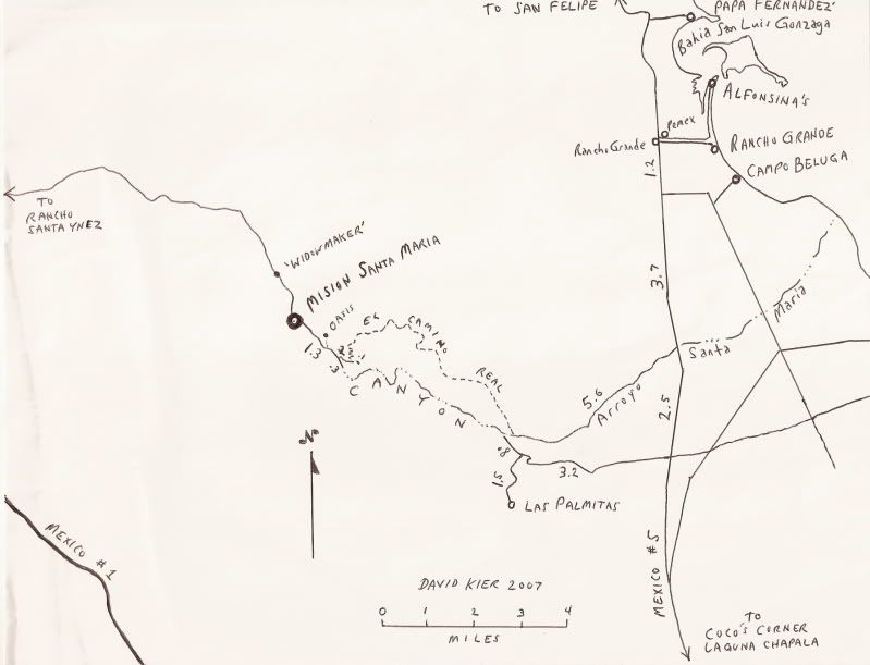
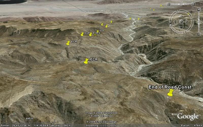
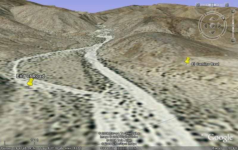
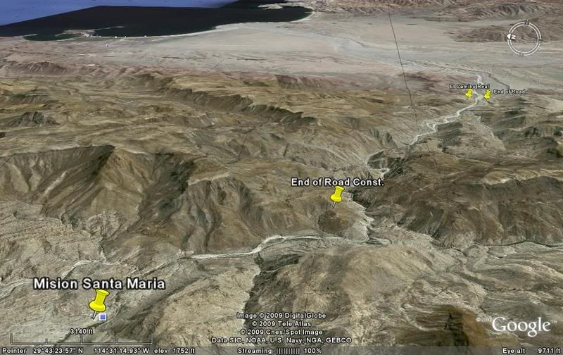
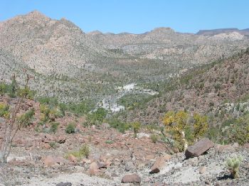
Yes, you can get as far as the entrance to the canyon facing Gonzaga Bay... about 1/4 mile past where the Camino Real mission trail leaves the arroyo
on the north bank to climb to the top of the north ridge of the canyon, which it follows to the mission valley. About a 6 hour casual hike!
Some maps to give you an idea:
1962:
2008:
Now some of mine...
2002:
2007:
I have the GPS of both ends of the Camino Real (where it leaves Arroyo Santa Maria on the Gonzaga side and where it meets the auto road, 1.5 miles
east of the mission). I have photos of those points too, in my web site trip pages.
The mission end of the Camino Real hike: http://vivabaja.com/msm/page8.html
The Gonzaga Bay end hike photos, and GPS begin here: http://www.vivabaja.com/1103/page2.html
GPS Directions (map datum NAD27 Mexico)
Take Hwy. 5 south 7.4 miles from Rancho Grande, turn west: 29°41.094'/ 114°24.566'
3.2 miles west of Hwy. 5, go straight where most traffic curves left for Las Palmitas: 29°41.278'/ 114°27.639'
0.8 miles from above, park at huge boulder: 29°41.68'/ 114°28.20'
Hike to north bank of Arroyo Santa Maria to: 29°41.733'/ 114°28.175' elev. 609' (ECR-1)
Go northwest and climb out of valley, note ocotillos.
Along left side of side valley: 29°42.374'/ 114°28.566' elev. 741' (ECR-2)
On first padre built switchback up: 29°42.669'/ 114°28.937' elev. 906' (ECR-3)
On a ridge, trail continues northwest: 29°42.671'/ 114°29.425' elev. 1308' (ECR-4)
On the Camino Real: 29°42.748'/ 114°29.482' elev. 1391' (ECR-5)
Crossing ridges and little mesas: 29°43.008'/ 114°29.967' elev. 1477' (ECR-6)
Drop along side of ridge, trail narrow: 29°43.074'/ 114°30.128' elev.1610' (ECR-7)
End of today's hike just beyond this last clear sign of the old trail: 29°43.141'/ 114°30.189' elev. 1702' (ECR-8)
Junction of ECR & bulldozed road: 29°43.126'/ 114°31.753' elev.1413'
(End of bulldozed road, on canyon ridge: 29°43.033'/ 114°31.556' elev. 1,615' )
Mision Santa Maria: 29°43.891'/ 114°32.794' elev.1628'
View east:
[Edited on 3-7-2013 by David K]
|
|
|
David K
Honored Nomad
Posts: 65586
Registered: 8-30-2002
Location: San Diego County
Member Is Offline
Mood: Have Baja Fever
|
|
| Quote: | Originally posted by brewer
We have a place on Gonzaga and want to do the trek to the mission ruins. Does anyone know how far you can get from the east close to it. Driving a
full size Dodge diesel.
Thanks for any info. |
Looking west, where the auto road ends and where the mission trail climbs up from the arroyo:
Looking towards the bay from above the mission:
[Edited on 3-7-2013 by David K]
|
|
|
Udo
Elite Nomad
Posts: 6364
Registered: 4-26-2008
Location: Black Hills, SD/Ensenada/San Felipe
Member Is Offline
Mood: TEQUILA!
|
|
Kewl photo of the big horn sheeps, DK.
The only ones I ever got to see in Baja was on a hike to El Picacho Del Diablo quite a few years ago.
Udo
Youth is wasted on the young!
|
|
|
David K
Honored Nomad
Posts: 65586
Registered: 8-30-2002
Location: San Diego County
Member Is Offline
Mood: Have Baja Fever
|
|
Thanks Udo... see more of them at http://vivabaja.com/msm
|
|
|
Mulegena
Super Nomad
Posts: 2412
Registered: 11-7-2006
Member Is Offline
|
|
Evoking Baja's magick
These photos bring you back to that place that's so peaceful and timeless, a trademark of the pristine beauty of this old world that is our Baja.
Mil Gracias!
How fortunate anyone is who gets to visit this remote place.
[Edited on 3-7-2013 by Mulegena]
"Raise your words, not your voice. It's rain that grows flowers, not thunder." ~Rumi
"It's the mark of an educated mind to be able to entertain a thought without accepting it." ~ Aristotle
|
|
|
David K
Honored Nomad
Posts: 65586
Registered: 8-30-2002
Location: San Diego County
Member Is Offline
Mood: Have Baja Fever
|
|
| Quote: | Originally posted by Mulegena
These photos bring you back to that place that's so peaceful and timeless, a trademark of the pristine beauty of this old world that is our Baja.
Mil Gracias!
How fortunate anyone is who gets to visit this remote place.
[Edited on 3-7-2013 by Mulegena] |
De nada!
Baja is a wonderful place for exploring, adventuring, and going back in time!
My last trip to the mission was 2010 with 5 other Baja Nomad vehicles and lots of Baja Nomads having fun... even with some vehicle damage and
breakdowns! The road to the mission is one of the great challenges Baja has to man and machine... under 15 miles, but a 3 hour drive!
See the 2010 Baja Nomad group trip: http://vivabaja.com/msm2010/
|
|
|
Barry A.
Select Nomad
Posts: 10007
Registered: 11-30-2003
Location: Redding, Northern CA
Member Is Offline
Mood: optimistic
|
|
David (and any others), does the road into the Mission Santa Maria seem to be deteriorating or staying the same over the years? (I think I know the
answer, but just checking)
Barry
|
|
|
wilderone
Ultra Nomad
Posts: 3914
Registered: 2-9-2004
Member Is Offline
|
|
There are other pools (and stream), not difficult to get to, that are at the bottom of a hill about a mile as the crow flys from the mission. At the
wide arroyo abovementioned, turn right and look for the old grading up a hill on the other side of the arroyo. Go up the hill; there are petroglyphs
on the rocks at the top of the hill there. Then look down into the arroyo canyon and see the stream and pools of water. Study the hill where the
petroglyphs are - you'll start to see a pathway, marked with ducks. I added twice as many when I went down, so there should be enough to spot. Hike
down following these ducks which will provide the easiest way.
|
|
|
David K
Honored Nomad
Posts: 65586
Registered: 8-30-2002
Location: San Diego County
Member Is Offline
Mood: Have Baja Fever
|
|
| Quote: | Originally posted by Barry A.
David (and any others), does the road into the Mission Santa Maria seem to be deteriorating or staying the same over the years? (I think I know the
answer, but just checking)
Barry |
Barry, I can only give you my observations from the 4 times I have been over it: 1999, 2003, 2007, 2010. Body damage from the rocks occurred each time
(the first time I was on a quad and the damage was to MY body, lol). However, the last time was the MOST difficult... and mostly because of the deep
water in the bog that time (more scary than difficult) Baja Tripper had no lockers, so he needed a pull through it both ways and Neal with a blown
rear differential needed to be pulled out through it... Also the sharp drop offs just before the mission (grabbed my bumper and Art's bumper). The
Widowmaker remains as the one single big obstacle that a lot of people won't drive down, fearing they can't drive back up it. So, they walk that last
1.4 miles to the mission.
|
|
|
David K
Honored Nomad
Posts: 65586
Registered: 8-30-2002
Location: San Diego County
Member Is Offline
Mood: Have Baja Fever
|
|
| Quote: | Originally posted by wilderone
There are other pools (and stream), not difficult to get to, that are at the bottom of a hill about a mile as the crow flys from the mission. At the
wide arroyo abovementioned, turn right and look for the old grading up a hill on the other side of the arroyo. Go up the hill; there are petroglyphs
on the rocks at the top of the hill there. Then look down into the arroyo canyon and see the stream and pools of water. Study the hill where the
petroglyphs are - you'll start to see a pathway, marked with ducks. I added twice as many when I went down, so there should be enough to spot. Hike
down following these ducks which will provide the easiest way. |
This is the 'Indian Trail' (and was the first El Camino Real, used by the Jesuits and by Serra on his walk to San Diego). The canyon route was so
difficult and dangerous, Serra ordered a better trail to be built and that is what we call the Camino Real today. It stays out of the canyon
completely. You can make out the Indian Trail on Google Earth, even though it isn't the highest resolution in that section of Baja.
Indian trail going down to the canyon bottom from the end of the 'bulldozed road' (where construction from Santa Ynez to Punta Final was abandoned 40
years ago):

Top of Indian Trail/ End of bulldozed road:
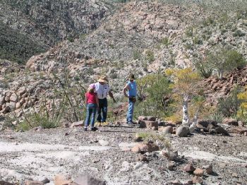
Petros:

View back towards mission, from the end of the bulldozed road (2 miles from the mission):
|
|
|
BajaLucy
Junior Nomad
Posts: 61
Registered: 12-6-2012
Location: Some place around Baja
Member Is Offline
Mood: {BajaTime}
|
|
This location sounds-looks like fun Im adding a mi lista D' Aventures en Baja 
In a world where You can Be Anything Be Yourself
|
|
|
BajaLucy
Junior Nomad
Posts: 61
Registered: 12-6-2012
Location: Some place around Baja
Member Is Offline
Mood: {BajaTime}
|
|
| Quote: | Originally posted by David K
| Quote: | Originally posted by Mulegena
These photos bring you back to that place that's so peaceful and timeless, a trademark of the pristine beauty of this old world that is our Baja.
Mil Gracias!
How fortunate anyone is who gets to visit this remote place.
[Edited on 3-7-2013 by Mulegena] |
De nada!
Baja is a wonderful place for exploring, adventuring, and going back in time!
My last trip to the mission was 2010 with 5 other Baja Nomad vehicles and lots of Baja Nomads having fun... even with some vehicle damage and
breakdowns! The road to the mission is one of the great challenges Baja has to man and machine... under 15 miles, but a 3 hour drive!
Pretty neat Report! Saw your other link for your trip report 2010 how cool all vehicles even camper that's awesome sounds you all had a blast txs for
posting'
See the 2010 Baja Nomad group trip: http://vivabaja.com/msm2010/ |
In a world where You can Be Anything Be Yourself
|
|
|
David K
Honored Nomad
Posts: 65586
Registered: 8-30-2002
Location: San Diego County
Member Is Offline
Mood: Have Baja Fever
|
|
Because it is so difficult to get to, it is even more special to go there... That's the way it was to go to Gonzaga Bay, and other Baja places before
they built new and paved roads... Bad roads act like a filter... keeps out the city riff raff... Mama Espinoza used to say "Bad Roads bring Good
People... Good Roads bring All Kinds of People".
|
|
|
MexicoTed
Senior Nomad
Posts: 708
Registered: 8-2-2004
Member Is Offline
|
|
Hi David:
I asked my buddy where he heard of "Poza de Escuadra"and he said it was on a map he saw at the old La Pinta when he was there about 12 years ago. He
said he has a photo, but can't find it yet. He said it looked like it was a mile or so away from the mission.
|
|
|
MexicoTed
Senior Nomad
Posts: 708
Registered: 8-2-2004
Member Is Offline
|
|
David:
I just did a search on Google just to make sure he wasn't nuts and found some mentions of Poza de Escuadra such as this;
"Perhaps the most magical part of Cataviña is its La Poza de Escuadra, a naturally occurring oasis in the middle of Cataviñas desert. This oasis is
said to possess actual magical qualities but whether that is the water source or the air or something entirely different remains to be seen
or,
perhaps, experienced!"
It came from this article (http://www.sandiegored.com/noticias/28827/Magical-Catavina-T...). Wonder if this is the same as your photos or a different place.
|
|
|
David K
Honored Nomad
Posts: 65586
Registered: 8-30-2002
Location: San Diego County
Member Is Offline
Mood: Have Baja Fever
|
|
| Quote: | Originally posted by MexicoTed
David:
I just did a search on Google just to make sure he wasn't nuts and found some mentions of Poza de Escuadra such as this;
"Perhaps the most magical part of Cataviña is its La Poza de Escuadra, a naturally occurring oasis in the middle of Cataviñas desert. This oasis is
said to possess actual magical qualities but whether that is the water source or the air or something entirely different remains to be seen
or,
perhaps, experienced!"
It came from this article (http://www.sandiegored.com/noticias/28827/Magical-Catavina-T...). Wonder if this is the same as your photos or a different place.
|
That article has a few holes in it... The hotel at Cataviña is NOT the Hotel Mision Santa Maria (that is in San Quintin area), but is instead is the
Hotel Mision Cataviña.
The actual mission of Santa Maria is 15 some miles east of Cataviña, is not mentioned. The article photo seems to be taken from the mission doorway,
but when I go to the link given with that photo I find nothing about Santa Maria or Cataviña in their search engine...?
Saying it is "just south" of El Rosario is a bit off unless you consider over 70 miles being "just". The Transpenisular Highway construction crews
actually met at San Ignacito, several miles south of Cataviña, in 1973. A plaque (now missing) was placed across from the now abandoned café, there.
One "giant" earthquake did not split Baja from the rest of Mexico, either... but maybe I am 'splitting hairs' now??? LOL
I do recall reading that oasis pool in my photos was called that name... I will see if I can find another source for you... But, it is approx. 1/2 to
1 mile east from the mission (as the crow flies).
[Edited on 3-8-2013 by David K]
|
|
|
David K
Honored Nomad
Posts: 65586
Registered: 8-30-2002
Location: San Diego County
Member Is Offline
Mood: Have Baja Fever
|
|
Ted, here's a article written by Nomad 'Rockman' many years ago (before Nomad)... and he and his friends hiked to the mission from south of Cataviña,
over the mountain. They then hiked on to near Gonzaga Bay... along the way he describes the oasis of my photos, but gives it no name. I still don't
know who made up that name... Perhaps it was someone online the past few years? Sort of like how my calling the bad grade near the mission
"Widowmaker" in 1999, and it stuck!
LINK: http://www.bajalife.com/v3pg40.htm
|
|
|
| Pages:
1
2 |


