Chupacabra
Nomad

Posts: 476
Registered: 7-11-2013
Location: La Jolla, CA
Member Is Offline
|
|
El Sauce de Carter
Anyone ever been there? It's a long way out there but for some reason sounds intriguing, if for no other reason than the name. It is mentioned
briefly in The Baja Adventure Book, but not much other than directions.
Who knows, it could be saucy.
|
|
|
David K
Honored Nomad
Posts: 65590
Registered: 8-30-2002
Location: San Diego County
Member Is Offline
Mood: Have Baja Fever
|
|
Yes! It was about 10 years ago... I was exploring the region around San Juan de Dios.
On accident (taking the more used looking road at a fork) I ended up there.
It is a rancho on the south side of Arroyo Grande with some large willow trees. The road crosses Arroyo Grande just east of the ranch and continues
ahead into the hills... at a fork, I took the right branch heading towards La Huertita trying to get near Matomi Peak. The left branch could be seen
going off a ways. A gate stopped me on the right branch. It wasn't locked, but I was wanting to get to San Juan de Dios before dark.
If I can dig up my mileage and GPS notes, I will add them here!
Baja Nomad 'Mexitron' knows this area better: http://vivabaja.com/mexitron
Arrow pointing to the site of the Franciscan or Dominican mission-era built visita ruins of San Juan de Dios, destroyed by a farmer in 2008.
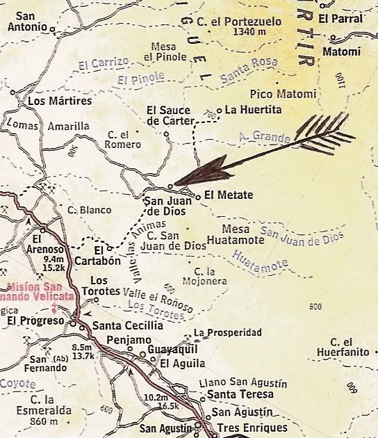
My photo on the right fork, north of El Sauce de Carter:

The distant mountain is Matomi.
[Edited on 10-22-2013 by David K]
|
|
|
David K
Honored Nomad
Posts: 65590
Registered: 8-30-2002
Location: San Diego County
Member Is Offline
Mood: Have Baja Fever
|
|
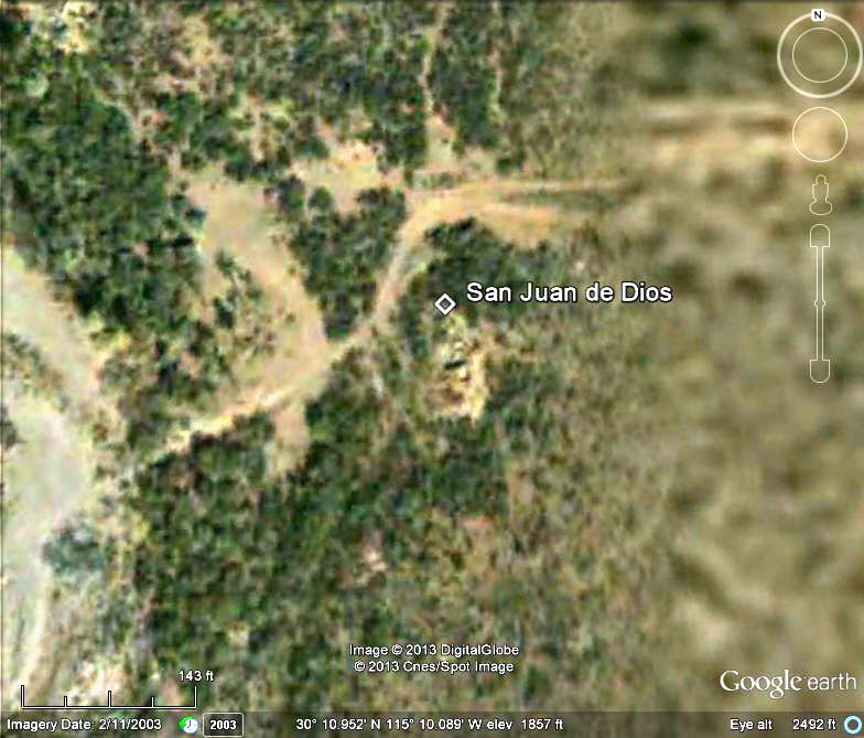
San Juan de Dios
The ruins as seen on Google Earth before they were destroyed... just below the diamond symbol:
My photo from 2000:
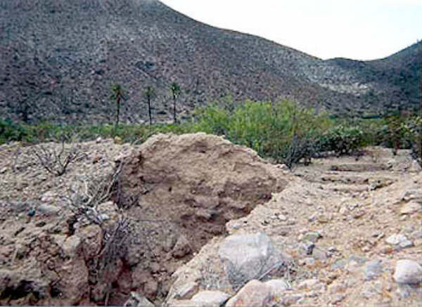
Jack Swords photo from 2003:
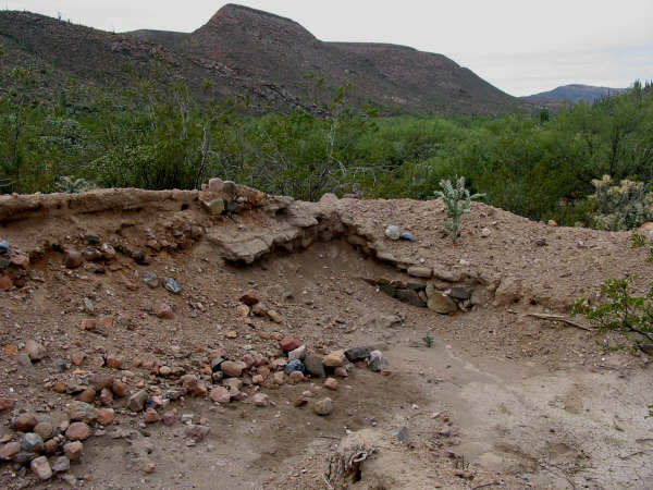
David M's photo from 2008:
|
|
|
David K
Honored Nomad
Posts: 65590
Registered: 8-30-2002
Location: San Diego County
Member Is Offline
Mood: Have Baja Fever
|
|
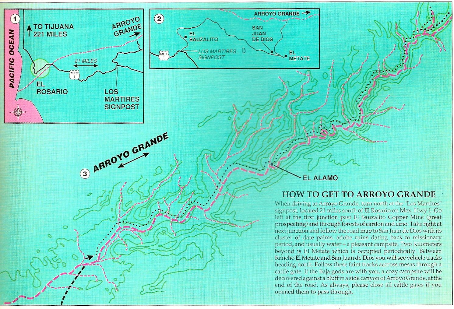
Ok... here's my 2002 Trip Report on the day I went by El Sauce de Carter: (note GPS is at NAD27 Mexico)
Baja Weekend Part 4 - Beyond San Juan de Dios
Sunday afternoon going north on Highway One, I stopped in Catavina to buy some gas from Alfonso ($3/gal for Magna). He also sells Premium. He said in
about a month, the Pemex pump in front of the hotel (across the street) would once again be working. Alfonso was not disappointed by the prospect of
being no longer needed. He said he would go fishing and enjoy life!
I stopped at many side roads to add GPS data and to map the relationship of Highway One to the old main road. The Baja Almanac and Topos are all wrong
in the San Agustin to Catavina area. They just paved the old road , which is a mile or more east of the new.
Between Km.103 and 104 is a cafe on the north side of road. This is the start of today's adventure... The road to San Juan de Dios and other interior
places begins here. The road first goes up the slope behind the cafe. This road has several forks and no signs! Sony Espinoza's tractor and some
copper mines are soon passed. The first fork is 2.5 miles from the highway, here turn left. The Sauzalito copper mine/ ghost town is another mile down
the road at N30º05.9' W115º21.8'.
The road turns north and crosses the San Juan de Dios river 1.3 miles from Sauzalito. In July of 2000 there was much more water and a pond with ducks!
Just 0.2 mi. past the river is the next fork. Left is a rarely used back road to El Rosario, go right. A major fork is reached 0.5 mi. from the river.
Left goes to Los Martires and on to San Quintin on the Baja 2000 racecourse of two years ago. Stay right and pass through an awesome boojum forest
that rivals any in Baja! I stopped along here and made myself a late lunch (2pm).
A rancher and his son drove up in an older Toyota 4WD truck and stopped to check on me. I told him I was going to San Juan de Dios and that I knew
Sony Espinoza (who owns the land). LdB and I met Sony and his family two years ago when he was using that tractor to build or repair roads. I asked
about the road to San Quintin over the mountains... muy malo? He said "si" but looked at my truck (also a Toyota), and said "no problema"! Si, si...
Toyota numero uno. It was a 'special' moment!
11.6 miles from the highway (5.4 from the river) is the next fork. To the left is a ranch, down in a valley, go right. A half mile later is an open
gate and another road left to the ranch. The road is now traveling east and a third road comes in from that ranch at the bottom of a grade. 15.6 miles
from the highway at 30º10.73'/ 115º15.55' is a crossroad. To the right goes to Cerro Blanco. Continue ahead.
Now, the next fork is a big one, and I took the wrong branch. It is 1.3 miles from the last one, at 30º10.98'/ 115º14.27'. Right goes to San Juan de
Dios, I went left. This would end up being an interesting mistake. I had read about El Sauce de Carter in Peterson's Baja Adventure Book. This left
fork goes 5.1 miles to the Arroyo Grande and El Sauce de Carter is in a stand of tall trees, just to the left along the (now dry) river bed. 'Sauce'
in Spanish means willow tree. Peterson tells of a 5-mile hike up the riverbed to a beautiful gorge with tall trees, blue palms, and huge pools.
The road on the map ends here... but a well-traveled road crosses the river bed going north. I go north! 1.3 miles from El Sauce de Carter is a major
fork (30º15.45'/ 115º12.98'). Both branches seem to go on forever. I take the right branch as it is heading straight for Matomi mountain! Having been
in Matomi Canyon several times (on the other side of the mountain), this interests me. I would love to find a short cut across Baja... would this road
take me to Puertecitos?
Nope! I arrive at a gate.... again! I am 2.8 miles from Arroyo Grande (Sauce de Carter) and must turn around. In the (1998) Baja Almanac go to page
N-16, Z-6, this new road's gate is almost at that bend in the trail shown going north to 'La Huertita'. Mount Matomi looms just beyond. So near, yet
so far!
I turn back, get back to 'right' road and arrive at San Juan de Dios 4.9 miles from the Sauce de Carter road. I have time to re-examine the ruins
there and the other adobe ruins that Jack Swords found, a mile beyond, just as the sun sets. San Juan de Dios is about 22 miles from Highway One over
a mostly good road. The waypoint for the mission visita ruins and Jack's other adobe ruins are on my Baja Missions web page, along with dozens of
other new and historic photographs: http://vivabaja.com/bajamissions Or, find the link on my Baja web site, http://vivabaja.com GPS waypoints on the Missions page are set to map datum WGS84. Waypoints in this article are set to NAD27, so you can plot
these spots on the topo maps. The final chapter is next...
|
|
|
Chupacabra
Nomad
Posts: 476
Registered: 7-11-2013
Location: La Jolla, CA
Member Is Offline
|
|
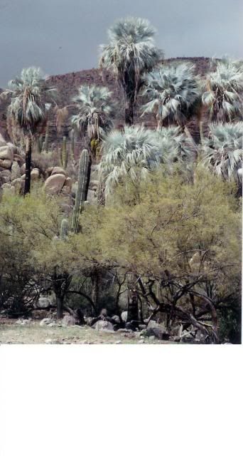
Wow, interesting... according to the Baja Adventure book if you hike in to the arroyo there are some beautiful pools, I wonder if they are year-round
or seasonal?
|
|
|
David K
Honored Nomad
Posts: 65590
Registered: 8-30-2002
Location: San Diego County
Member Is Offline
Mood: Have Baja Fever
|
|
The Arroyo Grande oasis has been mentioned in magazine articles and Nomads who have made the hike. I believe you can drive closer to them than El
Sauce de Carter, by going north from San Juan de Dios. I will try and dig up the magazine story...
|
|
|
David K
Honored Nomad
Posts: 65590
Registered: 8-30-2002
Location: San Diego County
Member Is Offline
Mood: Have Baja Fever
|
|
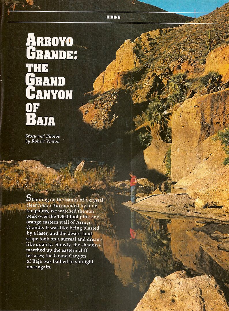
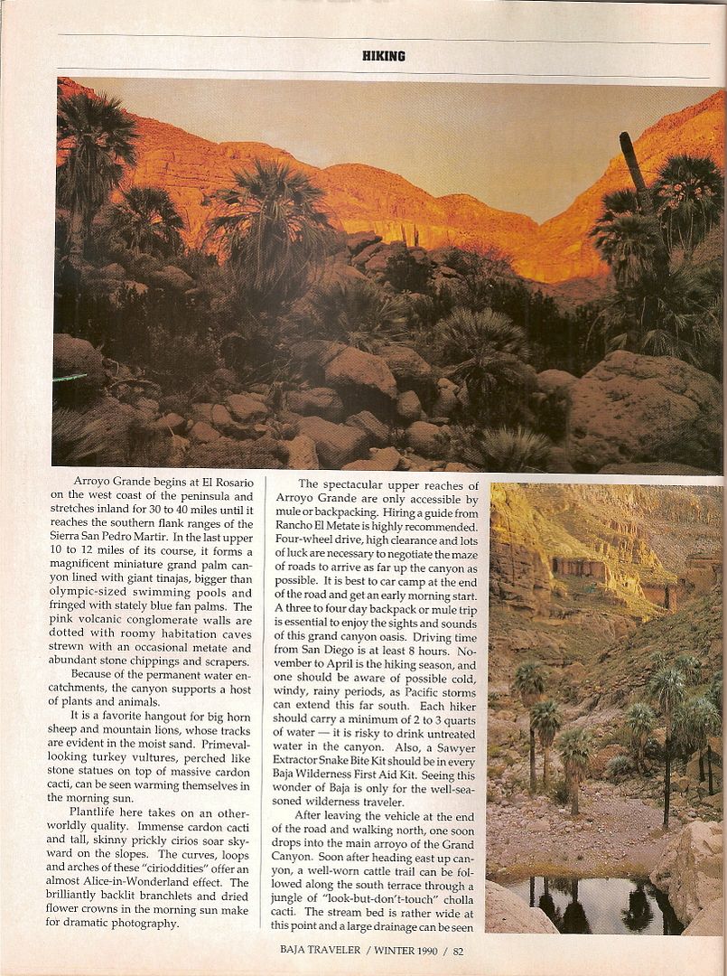
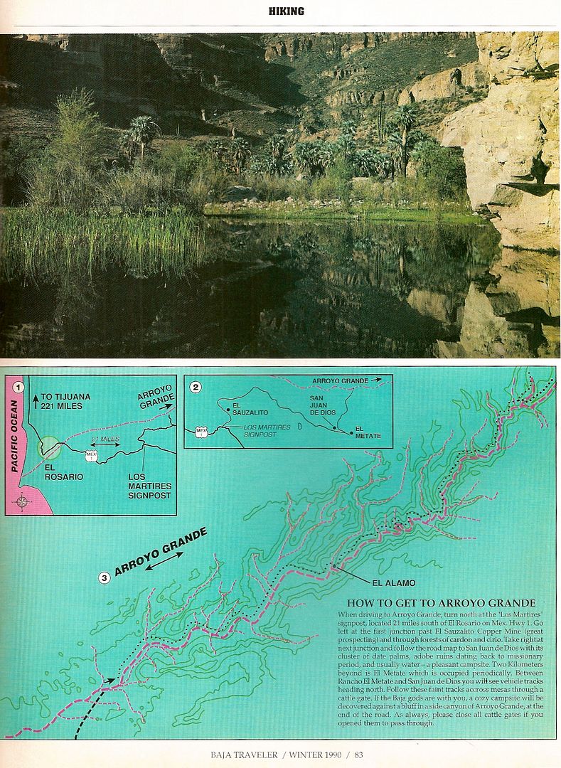
Winter 1990 Baja Traveler Magazine
An article on Arroyo Grande by Bicycle Bob/ Baja Bob:
|
|
|
mcfez
Elite Nomad
Posts: 8678
Registered: 12-2-2009
Location: aka BN yankeeirishman
Member Is Offline
|
|
Incredible this DavidK...........I am always amazed at the knowledge that you process about Baja.
Old people are like the old cars, made of some tough stuff. May show a little rust, but good as gold on the inside.
|
|
|
woody with a view
PITA Nomad
Posts: 15940
Registered: 11-8-2004
Location: Looking at the Coronado Islands
Member Is Offline
Mood: Everchangin'
|
|
and here i was think El Sauce de Tartar.....

|
|
|
Mexitron
Ultra Nomad
Posts: 3397
Registered: 9-21-2003
Location: Fort Worth, Texas
Member Is Offline
Mood: Happy!
|
|
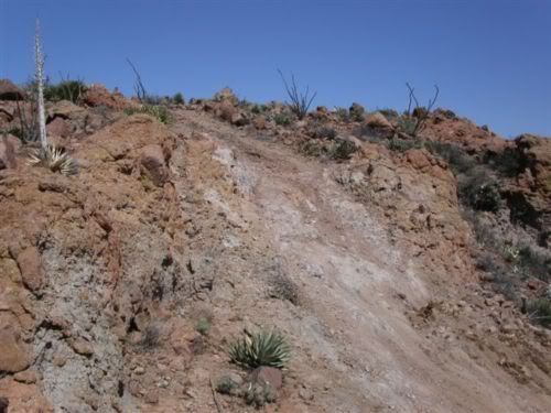
Thanks for that article on AG David---hadn't seen it. El Sauce de Carter itself is just a ranch, but the country around it is epic...have spent some
time in there and haven't even begun to cover it all. Botanically very interesting too as the northern chaparral remnants mix with Central Desert and
Eastern Gulf desert elements, along with coastal scrub and coastal sarcophyllous desert. And some gnarly four wheel driving over washed out Yucca
harvester roads:
|
|
|
David K
Honored Nomad
Posts: 65590
Registered: 8-30-2002
Location: San Diego County
Member Is Offline
Mood: Have Baja Fever
|
|
Would love to hear more Steve! I have also wanted to get back to San Juan de Dios... specially after the mission visita site there was bulldozed by
some farmer in or just before 2008. I camped by the other adobe were tracks go north across the arroyo towards Arroyo Grande, in 2002.
Sony Espinoza showed me the mission visita ruins in 2000, and I was under the impression it was all his family's land (just west of El Metate)... so
don't understand the destruction of an INAH recognized historic site when there is so much desert around.
How did you begin you climb of Matomi Mountain... from La Huertita, perhaps?
|
|
|
Chupacabra
Nomad
Posts: 476
Registered: 7-11-2013
Location: La Jolla, CA
Member Is Offline
|
|
That pond looks big, I wonder if there's enough water year-round to hold any fish?
************************************
WTF
|
|
|
Mexitron
Ultra Nomad
Posts: 3397
Registered: 9-21-2003
Location: Fort Worth, Texas
Member Is Offline
Mood: Happy!
|
|
| Quote: | Originally posted by David K
Would love to hear more Steve! I have also wanted to get back to San Juan de Dios... specially after the mission visita site there was bulldozed by
some farmer in or just before 2008. I camped by the other adobe were tracks go north across the arroyo towards Arroyo Grande, in 2002.
Sony Espinoza showed me the mission visita ruins in 2000, and I was under the impression it was all his family's land (just west of El Metate)... so
don't understand the destruction of an INAH recognized historic site when there is so much desert around.
How did you begin you climb of Matomi Mountain... from La Huertita, perhaps? |
We began the hike on a spur of a road coming off La Huertita--it was almost impassable and ended halfway up a mesa which was part of the Matomi
mesa/AG complex. So we camped there:

La Huertita:
And a view (that's me and Pappy) from east of R. El Metate looking at Pico Matomi and the surrounding Mesa Avion which Arroyo Grande cuts through:

|
|
|
David K
Honored Nomad
Posts: 65590
Registered: 8-30-2002
Location: San Diego County
Member Is Offline
Mood: Have Baja Fever
|
|
Amazing photos from a great isolated region... where many have searched for the Lost Mission...
The blue palms of La Huertita are fluorescent!
Looks like your photo was taken at the same place as Howard Gulick's in the 1950's!>>>

|
|
|
ELINVESTIG8R
Select Nomad
Posts: 15882
Registered: 11-20-2007
Location: Southern California
Member Is Offline
|
|
|
|
|
Mexitron
Ultra Nomad
Posts: 3397
Registered: 9-21-2003
Location: Fort Worth, Texas
Member Is Offline
Mood: Happy!
|
|
From the Matomi Mesa (4,200 ft) looking at Cerro San Juan de Dios:
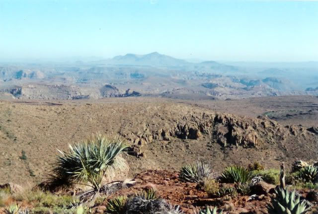
From Mesa Avion looking down at Arroyo Matomi:
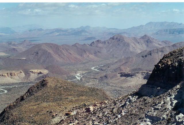
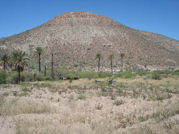
And near R. Martires on the way to El Sauce de Carter:
|
|
|
Mexitron
Ultra Nomad
Posts: 3397
Registered: 9-21-2003
Location: Fort Worth, Texas
Member Is Offline
Mood: Happy!
|
|
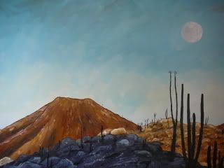
Hmm, last pic kind of small, here's a painting of it:
|
|
|


