| Pages:
1
2 |
David K
Honored Nomad

Posts: 65563
Registered: 8-30-2002
Location: San Diego County
Member Is Offline
Mood: Have Baja Fever
|
|
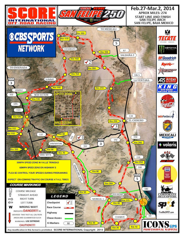
2014 San Felipe 250 Map (Mar. 1: Race Day)

Lot's of new territory for the 250...
(one loop, Four-wheeled vehicles and Pro Motos = 272 miles, Sportsman Moto = 250 miles)
[Edited on 2-14-2014 by David K]
|
|
|
Ateo
Elite Nomad
Posts: 5962
Registered: 7-18-2011
Member Is Offline
|
|
Man, my interest in this race has dropped significantly since the pro bikes are gone. Bummer! That's three less trips to Baja each year for me.
|
|
|
PaulW
Ultra Nomad
Posts: 3113
Registered: 5-21-2013
Member Is Offline
|
|
New outfit doing the maps. I will wait for the GPS files from BFG/SCORE.
Who knows maybe the map is in fact correct?
PW
|
|
|
David K
Honored Nomad
Posts: 65563
Registered: 8-30-2002
Location: San Diego County
Member Is Offline
Mood: Have Baja Fever
|
|
'New Junction' instead of Nuevo Junction... 
The map is from Score Facebook last night.
|
|
|
StuckSucks
Super Nomad
Posts: 2376
Registered: 10-17-2013
Location: Pacific Plate
Member Is Offline
|
|
I'll be there. Last I heard, my race team was talking about sending me into the bowels of Huatamote. Subject to change, of course.
|
|
|
PaulW
Ultra Nomad
Posts: 3113
Registered: 5-21-2013
Member Is Offline
|
|
| Quote: | Originally posted by StuckSucks
I'll be there. Last I heard, my race team was talking about sending me into the bowels of Huatamote. Subject to change, of course.
|
=======
Ha
That would be a real bummer since the race is not using Huatamote.
It enters Amarillas - thru the crossover and then heads west using Chanate.
PW
|
|
|
David K
Honored Nomad
Posts: 65563
Registered: 8-30-2002
Location: San Diego County
Member Is Offline
Mood: Have Baja Fever
|
|
Paul, if you have a better map than the one SCORE put out on Facebook the other night, I welcome you (or anyone else) to post it here!
Edit: I got a better image of the map and cropped it to bring in more map only detail.
[Edited on 2-14-2014 by David K]
|
|
|
StuckSucks
Super Nomad
Posts: 2376
Registered: 10-17-2013
Location: Pacific Plate
Member Is Offline
|
|
| Quote: | Originally posted by PaulW
That would be a real bummer since the race is not using Huatamote.
It enters Amarillas - thru the crossover and then heads west using Chanate.
PW |
Hummm ... guess that makes a difference.
|
|
|
StuckSucks
Super Nomad
Posts: 2376
Registered: 10-17-2013
Location: Pacific Plate
Member Is Offline
|
|
Also, note the bottom wash near RM20 is named differently on this map and the one at the top of the page (this one is from the SCORE site).
|
|
|
David K
Honored Nomad
Posts: 65563
Registered: 8-30-2002
Location: San Diego County
Member Is Offline
Mood: Have Baja Fever
|
|
I just changed the top map to the newer one, and cropped it to show more detail. Good eye on the changing Huatamote to Chanate! Now, if they would
only fix 'New Junction' to read the traditional 'Nuevo Junction'! 
|
|
|
PaulW
Ultra Nomad
Posts: 3113
Registered: 5-21-2013
Member Is Offline
|
|
| Quote: | Originally posted by David K
Paul, if you have a better map than the one SCORE put out on Facebook the other night, I welcome you (or anyone else) to post it here!
Edit: I got a better image of the map and cropped it to bring in more map only detail.
[Edited on 2-14-2014 by David K] |
====
Sorry for the late post.
DK - your edit to add Chanate is correct
Typical oversight by the map maker who is unfamiliar with the terrain or Baja in general. Huatamote is further south and on a map it looks different.
The error is compounded because Chanate is not shown on commonly use or picture. I caught the error immediately and it is now confirmed by looking at
the GPS file. Put the GPS file on Google Earth and see the terrain. Yes there are better maps, but all are private and so as not to get in trouble
with SCORE none are publicly posted. In the past BFG posted their race map on their web site, but this year the map was made by a new company and the
BFG has not published their map.
One has to note that I have driven all these washes more times than I can count, so familiarity helps.
No time now for a mapping exercise to help unfamiliar persons with all the details. Maybe later??
PW
|
|
|
TMW
Select Nomad
Posts: 10659
Registered: 9-1-2003
Location: Bakersfield, CA
Member Is Offline
|
|
The BFG map is on the RLH site.
http://rlhcomm.com/BFG/RACES/2014/San%20Felipe/BFG-SF250_201...
|
|
|
willardguy
Elite Nomad
Posts: 6451
Registered: 9-19-2009
Member Is Offline
|
|
SPEED Mex Pits Services San Felipe 250 PreRun
Manuel Morales will be camping out this weekend to provide a prerunning pit at Race Mile 194. He will have fuel for purchase, food, and water. He is
planning to be there the 15th, and until 3:30 or 4PM on the 16th.
He will be providing the same service from the 22nd of February until February 28th. SPEED Mex Pits
|
|
|
David K
Honored Nomad
Posts: 65563
Registered: 8-30-2002
Location: San Diego County
Member Is Offline
Mood: Have Baja Fever
|
|
Tom, that is the same (Score) map, but with a BFG truck at Valle de Trinidad added. Thank you for the link!
|
|
|
PaulW
Ultra Nomad
Posts: 3113
Registered: 5-21-2013
Member Is Offline
|
|
Wash details
Refer to the GPS screen shots
The entrance to Amarillas at VCP 8 at the Right up Wash
The exit of Amarillas at VCP 9 at an easy left. And use the crossover Connector to get to Chanate.
The entrance to Chanate at VCP 10 at the hard Right turn
Further west not shown near RM 27 is the exit of Chanate, then at about RM 29.5 right turn and head north toward Morelia Junction.


|
|
|
TMW
Select Nomad
Posts: 10659
Registered: 9-1-2003
Location: Bakersfield, CA
Member Is Offline
|
|
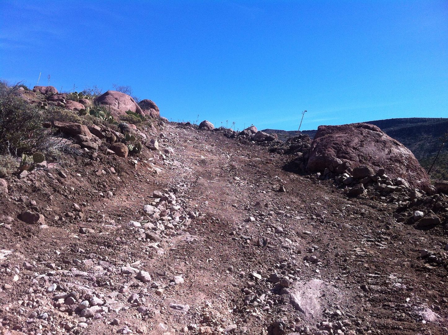
The road leading up to the summit was in bad shape with many pre-runners having lots of problems including MCs. SCORE had a dozer fix the problem.
It's part of Normans newer and smoother 250 race course.
|
|
|
StuckSucks
Super Nomad
Posts: 2376
Registered: 10-17-2013
Location: Pacific Plate
Member Is Offline
|
|
| Quote: | Originally posted by PaulW
Refer to the GPS screen shots |
It appears to be a Lowrance GPS - if so, what model? And how did you get screen shots?
|
|
|
StuckSucks
Super Nomad
Posts: 2376
Registered: 10-17-2013
Location: Pacific Plate
Member Is Offline
|
|
Always subject to change, but I just heard I'm working somewhere near Mike's SR.
|
|
|
TMW
Select Nomad
Posts: 10659
Registered: 9-1-2003
Location: Bakersfield, CA
Member Is Offline
|
|
Anywhere around Mikes can get really cold at night, even in June, so take warm clothes and sleeping gear.
|
|
|
PaulW
Ultra Nomad
Posts: 3113
Registered: 5-21-2013
Member Is Offline
|
|
| Quote: | | It appears to be a Lowrance GPS - if so, what model? And how did you get screen shots? |
===
Lowrance 7200c with Murdock map v8-2013
Click Menu- Menu - activate Screen shot. The press power for a second. Result is a prompt that tells you the image number. Do it again because
sometimes it is sensitive to how long you push. Push to long and the darn thing turns off. Push to short and it dims the screen. Sigh. Do the screen
shot after creating the picture by zooming and adjusting brightness etc. so as to show the contour lines and maximum details. Screen shot is
rerecorded on your Map SD as a JPG.
I think all models of the 7200 vintage do screen shots as do all the HDS units. Back when 7200c were sold the also had 10" and 12". IF one were to
look for a unit that has screen shot capability I would suggest referring to the specs from the lowrance or a vendor.
I don't know If I will ever get my Garmin to match the Lowrance?? Working on learning.
PW
|
|
|
| Pages:
1
2 |


