BajaBusDriver
Newbie
Posts: 10
Registered: 10-8-2010
Member Is Offline
|
|
Punta Canoas to Rosalillita?
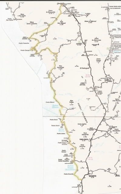
Hello everyone. I'm hoping to drive into Punta Canoas and take the coast "road" down through the 7 sisters. One pretty burly, albeit heavy, 4X4.
and a lighter weight 4X4. Plan on walking any questionable sections and or send the light rig in front to probe so the bigger rig can easily pull it
out before getting stuck.
Has anyone heard anything about this stretch of the coast since Odile hit?
Thanks in advance.
Rob
|
|
|
BooJumMan
Senior Nomad
  
Posts: 932
Registered: 8-11-2007
Location: San Diego
Member Is Offline
|
|
Haven't heard since Odile ... But if you've done it before you probably know of the problem areas. Assuming there are bypasses by now though...
Jealous I can't get down there and give you a first hand report, thats for sure. 
Id say get a strap for sure. One guy goes into something sketchy, the other guy can pull him out!
[Edited on 10-25-2014 by BooJumMan]
|
|
|
BajaBusDriver
Newbie
Posts: 10
Registered: 10-8-2010
Member Is Offline
|
|
Thanks BooJumMan!
Have you done that drive. I have not. I have heard there are some problem areas, mainly silt beds, and I've heard they are bad between Punta Maria
and Blanca, but other than that I don't really know the problem areas.
If you have any more info I'd take it.
Thanks in advance.
Rob
|
|
|
TMW
Select Nomad
      
Posts: 10659
Registered: 9-1-2003
Location: Bakersfield, CA
Member Is Offline
|
|
We drove the coast from Santa Rosalillita to Punta Canoas in July without any problems. There are silt beds in some locations but not a problem just
pick a good line and if necessary have one 4x4 wait till the other is thru. From Punta Canoas you'll go east to a jct at 29-27.470x115-09.630. Go
right and it will take you to the coast, stay on the best used road. Just before the coast there is a house set back with a fence around it and a road
next to the fence. Take that road and it will shortly wind over to the coast. This coastal road is a good graded road that will take you the San Jose
area and the coastal road along the 7 sisters. Remember stay on the most used road.
There are a couple of places where you may have to take a wide sweep inland to skirt the marsh areas but no big deal. North of Punta Blanco at
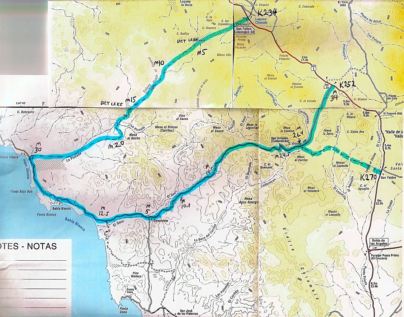
29-10.800x114-44..260 is a jct with a road that goes to Chapala at Hwy1 KM233. Further along the coast after Punta Blanco you will start inland for a
piece and come to a Jct at 29-05.400x114-36.050. If you go right it will take you over a hill and out to the coast but this is a road with lots of
silt so be carefull. If you go straight it will take you to another Jct at 29-05.600x114-32.140. Watch for an abondoned ranch with a windmill. This
is called Cordornices in the almanac. Further east is a rancho on the north side of the arroyo area that you should see. Straight at the Jct goes to
Hwy1 at KM252, Go right. This will come near the coast at Punta Cono and past there San Jose de las Palomas.
Have a good trip, be safe.
|
|
|
David K
Honored Nomad
        
Posts: 65437
Registered: 8-30-2002
Location: San Diego County
Member Is Offline
Mood: Have Baja Fever
|
|
Here's the TW Loop route (the road from Laguna Chapala to the Pacific is not on any published maps, yet):

The M numbers are the Mileages (every 5 mostly) from Chapala to the coast; then the mileage to the second road back to Hwy. 1; then the mileages from
that point near the coast back to Hwy. 1.
In 2007, we drove the coast road using this route... it is a nice example of what traveling down Baja was before Hwy. 1... specially on the non-graded
sections...

[Edited on 10-25-2014 by David K]
|
|
|
Tomas Tierra
Super Nomad
   
Posts: 1281
Registered: 3-23-2005
Location: oxnard, ca
Member Is Offline
Mood: Tengo Flojera
|
|
I don't think there was any rain in that area to speak of from Odile...I was in the neighborhood during Odile..
But a few weeks later, 40 miles north, 12.5 inches were rumored to have fallen.. Don't be surprised to find the de-fabled 7 hermanas road torn to
absolute shreds... Do not have a confirmed report on that stretch of road though...
Good luck! If it's good, don't report back 
TT
|
|
|
BooJumMan
Senior Nomad
  
Posts: 932
Registered: 8-11-2007
Location: San Diego
Member Is Offline
|
|
| Quote: | Originally posted by Tomas Tierra
Good luck! If it's good, don't report back 
|
AMEN!!! 
|
|
|
DawnPatrol
Nomad
 
Posts: 357
Registered: 11-19-2013
Member Is Offline
|
|
Did the route outlined in yellow by David K a couple years ago, except we cut in the route a little to the North of Catavina
You should have zero problems.. the track fades a bit in spots early on but that area is hard pack anyways...
Close to Pta Canoa & Pta Blanco its a very easy trail
we did have to cut in off the coast for just a bit
You will have a blast!
Alan from San Diego
|
|
|
BajaBusDriver
Newbie
Posts: 10
Registered: 10-8-2010
Member Is Offline
|
|
Thanks a lot everyone!! Just finishing up the last bit of packing, then heading down next week! Psyched. Thanks again for all the info! TW, I'll put
those coordinates into my gps.
Rob
|
|
|
DawnPatrol
Nomad
 
Posts: 357
Registered: 11-19-2013
Member Is Offline
|
|
when I said the track fades a little , that was from the point where we turned south, not on the way in from the east to the beach, that trail/road
was decent
have fun!
Alan
|
|
|
ajr123
Newbie
Posts: 1
Registered: 11-26-2017
Member Is Offline
|
|
Has anyone taken the road from Chapala to the coast recently?
Has anyone driven the road from Chapala to the coast recently? Look like an awesome trail through some dry lakes and good way to get north of Punta
Blanco! Any tough obstacles I should be concerned with? Is the other road that cuts up to the 1 at km 252 better? Any tips or advice would be
appreciated. Thanks.
Quote: Originally posted by David K  | Here's the TW Loop route (the road from Laguna Chapala to the Pacific is not on any published maps, yet):

The M numbers are the Mileages (every 5 mostly) from Chapala to the coast; then the mileage to the second road back to Hwy. 1; then the mileages from
that point near the coast back to Hwy. 1.
In 2007, we drove the coast road using this route... it is a nice example of what traveling down Baja was before Hwy. 1... specially on the non-graded
sections...

[Edited on 10-25-2014 by David K] |
|
|
|
Tomas Tierra
Super Nomad
   
Posts: 1281
Registered: 3-23-2005
Location: oxnard, ca
Member Is Offline
Mood: Tengo Flojera
|
|
Rumor I heard last was five hours and not very nice. I forget the guys name at the Chapala tire shop, but he confirmed that report in April.
|
|
|
mjs
Nomad
 
Posts: 334
Registered: 2-20-2013
Location: Off grid in San Felipe
Member Is Offline
|
|
Drive both routes in Oct. Some deep silt on both. The road to k252 is washed out around the M5 intersection IIRC. There is a bypass around/thru a
ranch. Scenic route but definitely 4x4. We were in a short wheelbase H3 and had no problems. Not sure I'd want to take my LWB Dodge CC through there.
|
|
|

