| Pages:
1
2
3
4 |
StuckSucks
Super Nomad
   
Posts: 2369
Registered: 10-17-2013
Location: Pacific Plate
Member Is Offline
|
|
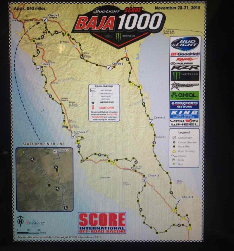
2015 Baja 1000 map
SCORE Press Release
Roughly the same as 2013 but run anti-clockwise this time.

|
|
|
David K
Honored Nomad
        
Posts: 65416
Registered: 8-30-2002
Location: San Diego County
Member Is Offline
Mood: Have Baja Fever
|
|
Cool... El Rosario and Coco's Corner! Notice how they are avoiding Calamajué Canyon???
|
|
|
AKgringo
Elite Nomad
     
Posts: 6281
Registered: 9-20-2014
Location: Anchorage, AK (no mas!)
Member Is Offline
Mood: Retireded
|
|
David, Why do you suppose they are not using the canyon? That is a pretty neat stretch of the course, and no conflict with traffic until they get to
Coco's Corner.
If you are not living on the edge, you are taking up too much space!
"Could do better if he tried!" Report card comments from most of my grade school teachers. Sadly, still true!
|
|
|
David K
Honored Nomad
        
Posts: 65416
Registered: 8-30-2002
Location: San Diego County
Member Is Offline
Mood: Have Baja Fever
|
|
Quote: Originally posted by AKgringo  |
David, Why do you suppose they are not using the canyon? That is a pretty neat stretch of the course, and no conflict with traffic until they get to
Coco's Corner. |
Good question!
If it had been a wet year, I would say because of the amount of water... I was manning the El Crucero checkpoint pit in 2006, and it was so flooded in
there, many racers got stuck and delayed from the backup it created. Maybe, a cry out to preserve the beautiful canyon road had them go back to Hwy. 1
and up from Chapala to Coco's. Maybe it will be the last time to use the Chapala to Coco's road before it gets PAVED!???
|
|
|
David K
Honored Nomad
        
Posts: 65416
Registered: 8-30-2002
Location: San Diego County
Member Is Offline
Mood: Have Baja Fever
|
|
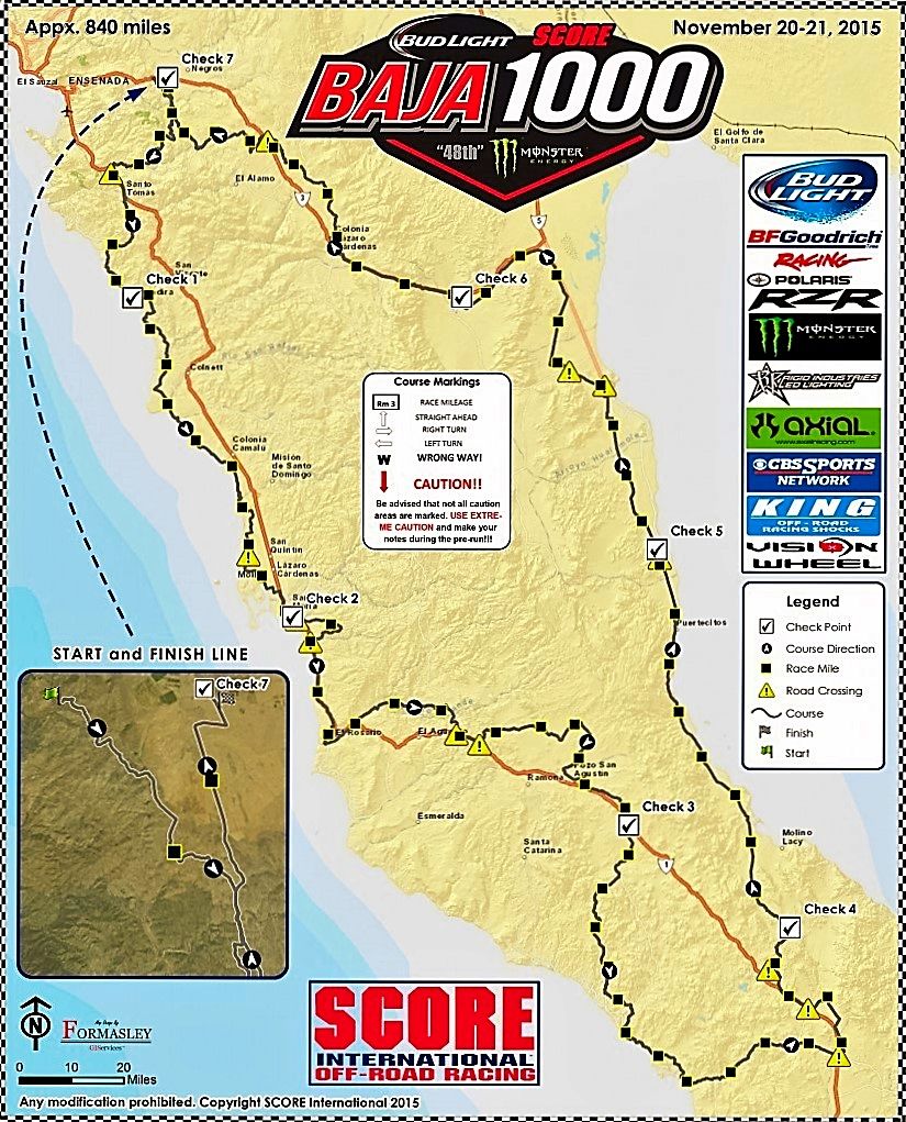
Here's another version of the map above...

|
|
|
TMW
Select Nomad
      
Posts: 10659
Registered: 9-1-2003
Location: Bakersfield, CA
Member Is Offline
|
|
Word is that Calamajue canyon is off limits due to environmental concerns.
|
|
|
StuckSucks
Super Nomad
   
Posts: 2369
Registered: 10-17-2013
Location: Pacific Plate
Member Is Offline
|
|
In the 2013 1000, our TT hit a 3' rock hiding behind a bush in Calamajué Canyon. They moved the rock about 1", but that ended their day. Probably just
as well we're not running through there.

|
|
|
David K
Honored Nomad
        
Posts: 65416
Registered: 8-30-2002
Location: San Diego County
Member Is Offline
Mood: Have Baja Fever
|
|
Cool photo, sad owie.
|
|
|
blackwolfmt
Senior Nomad
  
Posts: 802
Registered: 1-18-2014
Location: On The Beach With A Blackwolf
Member Is Offline
Mood: dreamin of Riden out a hurricane in Baja
|
|
Refresh my memorie wouldn't it be counter not anti clock wise LOL gonna try and be there eitherway and that front end took a beatin
[Edited on 10-5-2015 by blackwolfmt]
So understand dont waste your time always searching for those wasted years
face up and make your stand and realize that your living in the golden years
|
|
|
David K
Honored Nomad
        
Posts: 65416
Registered: 8-30-2002
Location: San Diego County
Member Is Offline
Mood: Have Baja Fever
|
|
Those who speak the Queen's English say "anti-clockwise"... we here in the Colonies say "counter-clockwise".
Some other oddities: windscreen vs. windshield, spanner vs. wrench, boot vs. trunk, bonnet vs. hood, petrol vs. gasoline, tyre vs. tire, etc.
 
|
|
|
StuckSucks
Super Nomad
   
Posts: 2369
Registered: 10-17-2013
Location: Pacific Plate
Member Is Offline
|
|
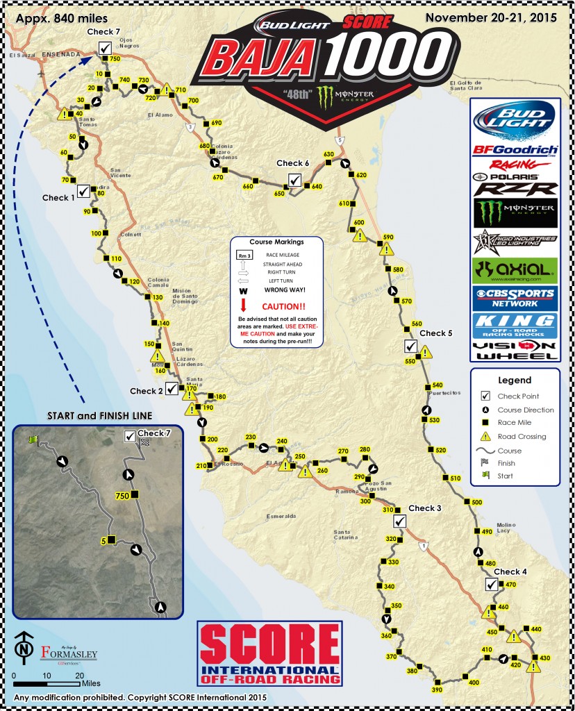
And yet another iteration:

|
|
|
David K
Honored Nomad
        
Posts: 65416
Registered: 8-30-2002
Location: San Diego County
Member Is Offline
Mood: Have Baja Fever
|
|
Interesting that Mile 10 (and Mile 5 in the insert map) is so close to Ojos Negros, yet more than 10 miles from Ensenada??? That shows the race
starting near Ojos and not in Ensenada... perhaps???
[Edited on 10-5-2015 by David K]
|
|
|
StuckSucks
Super Nomad
   
Posts: 2369
Registered: 10-17-2013
Location: Pacific Plate
Member Is Offline
|
|
That's what I'm seeing as well. The race finishes in Ojos Negros and starts just west of there. I just looked at SCORE's schedule and there's no
mention about starting/finishing out of town.
|
|
|
David K
Honored Nomad
        
Posts: 65416
Registered: 8-30-2002
Location: San Diego County
Member Is Offline
Mood: Have Baja Fever
|
|
Check 7 is Ojos, so the finish will be in Ensenada it would seem?
|
|
|
blackwolfmt
Senior Nomad
  
Posts: 802
Registered: 1-18-2014
Location: On The Beach With A Blackwolf
Member Is Offline
Mood: dreamin of Riden out a hurricane in Baja
|
|
Comprende thanks DK
So understand dont waste your time always searching for those wasted years
face up and make your stand and realize that your living in the golden years
|
|
|
TMW
Select Nomad
      
Posts: 10659
Registered: 9-1-2003
Location: Bakersfield, CA
Member Is Offline
|
|
On the SCORE web site if you look at the schedule of events it says the party Thursday evening is Adjacent to the S/F line which is in front of the
Convention Center.
The start and finish is similar to the 2014 Baja 500.
|
|
|
rts551
Elite Nomad
     
Posts: 6700
Registered: 9-5-2003
Member Is Offline
|
|
From the Score web site
The start is in Ensenada: the portion from Ensenada to Ojos is not shown due to prerunning restrictions. Prerunning the start will be open only
November 18th and 19th, outbound only.
|
|
|
David K
Honored Nomad
        
Posts: 65416
Registered: 8-30-2002
Location: San Diego County
Member Is Offline
Mood: Have Baja Fever
|
|
Yes, that has been true of most recent SCORE maps (not showing the Ensenada to Ojos Negros section). I just don't recall them not including the
estimated miles from Ensenada to Ojos in the overall distance figures?
I think they are just showing displayed course miles from Ojos area and not actual race course miles from the start, if Ensenada.
Check 7 (Ojos) is about Map Mile 752. If it is an 840 mile race, there are 88 miles not shown. About 44 miles each way (Ensenada to Ojos and Ojos to
Ensenada).
So, if you want to know the actual Race Mile on a point on that map, I am thinking you would add 44 miles to the Map Mile numbers, yes?
Check 3 (north of Cataviña) is Map Mile 310, but is Race Mile 354 if the course remains the same and it is 44 miles out from Ensenada to Map Mile 0.
|
|
|
PaulW
Ultra Nomad
    
Posts: 3113
Registered: 5-21-2013
Member Is Offline
|
|
So far there are several conflicting maps (4). I think there must be a new map guy? Or several? Usually I can count on the BFG map? Usually the tracks
Ensenada to - from Ojos are not revealed until contingency.
More turmoil - expect the GPS track a couple of days before prerunning and then revisions will start to flow.
I wonder when prerun starts?
|
|
|
BooJumMan
Senior Nomad
  
Posts: 930
Registered: 8-11-2007
Location: San Diego
Member Is Offline
|
|
I heard pre-running starts on Nov 1st from an old friend at McMillin
|
|
|
| Pages:
1
2
3
4 |

