| Pages:
1
2
3 |
bajatrailrider
Ultra Nomad

Posts: 2553
Registered: 1-24-2015
Location: Mexico
Member Is Offline
Mood: Happy
|
|
Can you Help David
David we have been exploring new routes from San Quintin to El Rosario.For over 5 years.We have new route,not on any map we have.All the routes East
side Highway 1.If you leave SQ going south pavement 1 you get to point where old paved road meets new.Past last bridge from SQ.Right where they meet
we go Lt East.Take dirt road back about 50 miles east.Road then ends at our freinds rancho She is Daniel Arce .If you go south many roads go to El
Rosario.She told us there is old road Out her rancho going south to Vicente Guerro.Anyway you could find any routes,on your maps.Because we will
already be into ride over 50 miles.We will not have room for,out of gas,or daylight.As we are sure there will be many,roads that Y off to dead ends.To
use up our fuel,and daylight.Thanks for any help David.We will head out OCT 30. Five bikes,big tanks,carry two spare gal gas.
|
|
|
David K
Honored Nomad
Posts: 65562
Registered: 8-30-2002
Location: San Diego County
Member Is Offline
Mood: Have Baja Fever
|
|
Quote: Originally posted by bajatrailrider  | | David we have been exploring new routes from San Quintin to El Rosario.For over 5 years.We have new route,not on any map we have.All the routes East
side Highway 1.If you leave SQ going south pavement 1 you get to point where old paved road meets new.Past last bridge from SQ.Right where they meet
we go Lt East.Take dirt road back about 50 miles east.Road then ends at our freinds rancho She is Daniel Arce .If you go south many roads go to El
Rosario.She told us there is old road Out her rancho going south to Vicente Guerro.Anyway you could find any routes,on your maps.Because we will
already be into ride over 50 miles.We will not have room for,out of gas,or daylight.As we are sure there will be many,roads that Y off to dead ends.To
use up our fuel,and daylight.Thanks for any help David.We will head out OCT 30. Five bikes,big tanks,carry two spare gal gas. |
See the maps (the 2009 with my pencilled-in additions) I posted on Baja Bucko's post today asking about Rancho el Rosarito up there... I drove the
back way from El Socorro towards El Rosarito and then that drops down to Hwy. 1 via Rancho Martires to Sauzalito and near El Arenoso.
HERE: http://forums.bajanomad.com/viewthread.php?tid=80583
More later...
[Edited on 10-18-2015 by David K]
|
|
|
DENNIS
Platinum Nomad
Posts: 29510
Registered: 9-2-2006
Location: Punta Banda
Member Is Offline
|
|
David...do you need help? 
"YOU CAN'T LITTER ALUMINUM"
|
|
|
Bajahowodd
Elite Nomad
Posts: 9274
Registered: 12-15-2008
Location: Disneyland Adjacent and anywhere in Baja
Member Is Offline
|
|

|
|
|
David K
Honored Nomad
Posts: 65562
Registered: 8-30-2002
Location: San Diego County
Member Is Offline
Mood: Have Baja Fever
|
|
Sure Dennis... what have you got? More than a bunch of laughing heads I hope?
My explorations into the San Pedro Martir are pretty limited. To the observatory, Mike's Sky Rancho north and south access roads, and that high road
around El Rosario, that got near El Rosarito, I mentioned before...
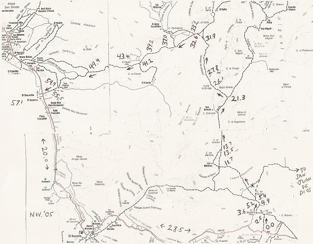
Mile 32.6 is the closest I got to El Rosarito, maybe 8 miles away.
|
|
|
liknbaja127
Nomad
Posts: 464
Registered: 1-17-2012
Member Is Offline
|
|
How about the 1000 maps, or BFG, chase books for the 0-12 or 0-13
race? may be something on there that could help?
|
|
|
bajatrailrider
Ultra Nomad
Posts: 2553
Registered: 1-24-2015
Location: Mexico
Member Is Offline
Mood: Happy
|
|
That route maybe from 07 Race.The above map hard to
see,dont think it goes North enough.Will look at other post you mentioned David.We have explored over 7 routes (all East) from San Quintin to El
Rosario.We have one more to go,also From Danielas Rancho.There is road that goes up to forest.We went up it last year,but turned tail because it was
getting late.As last resort,We will truck bikes,to her rancho.Base camp there till we find it another time.
|
|
|
bajatrailrider
Ultra Nomad
Posts: 2553
Registered: 1-24-2015
Location: Mexico
Member Is Offline
Mood: Happy
|
|
Thank you guys,In other post buckos that looks like the road we are after last Map.Will check it out.
|
|
|
David K
Honored Nomad
Posts: 65562
Registered: 8-30-2002
Location: San Diego County
Member Is Offline
Mood: Have Baja Fever
|
|
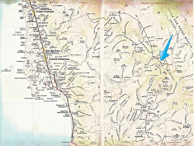
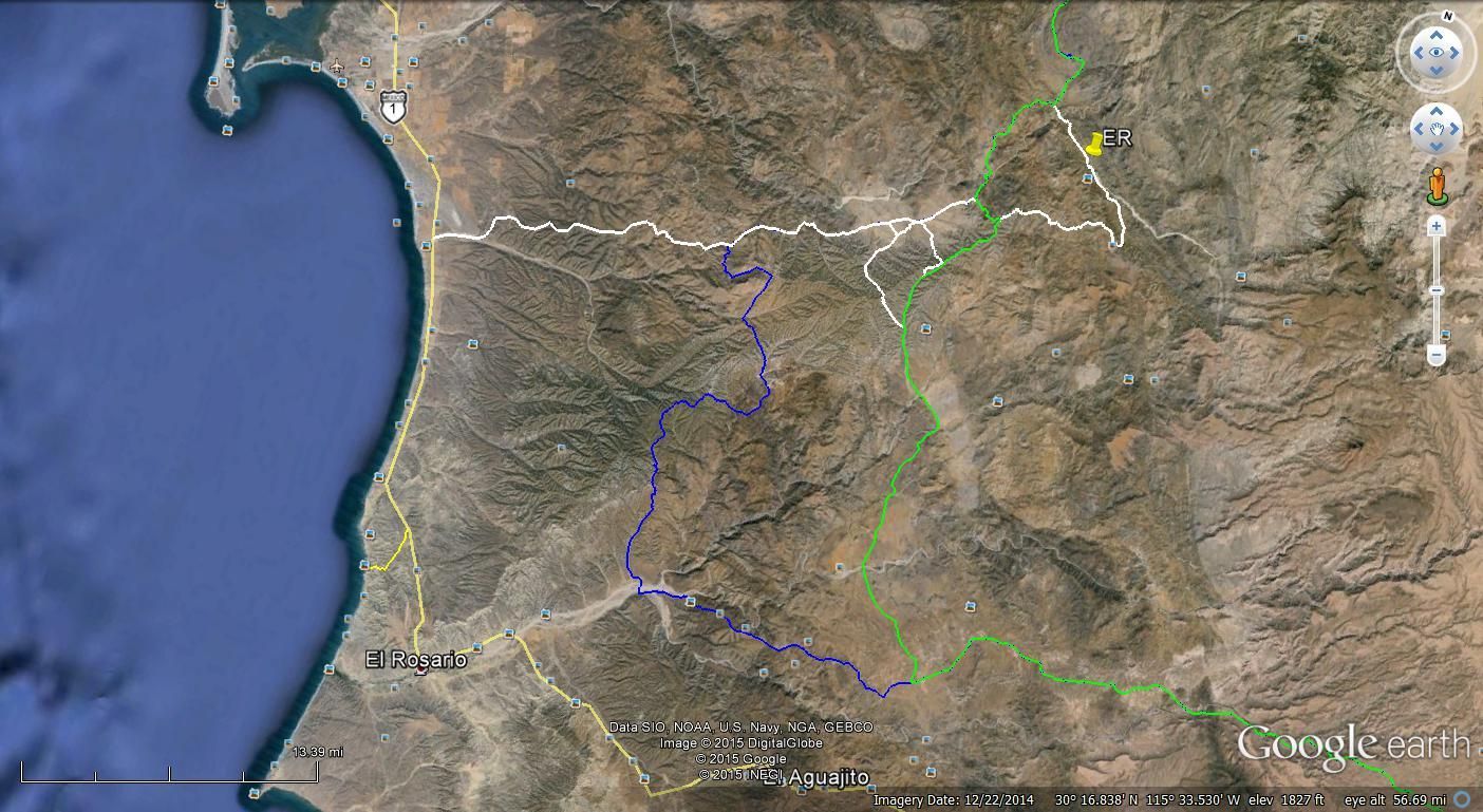
Arrow points to El Rosarito
Then TW posted this, seems Score used that high road:

|
|
|
TMW
Select Nomad
Posts: 10659
Registered: 9-1-2003
Location: Bakersfield, CA
Member Is Offline
|
|
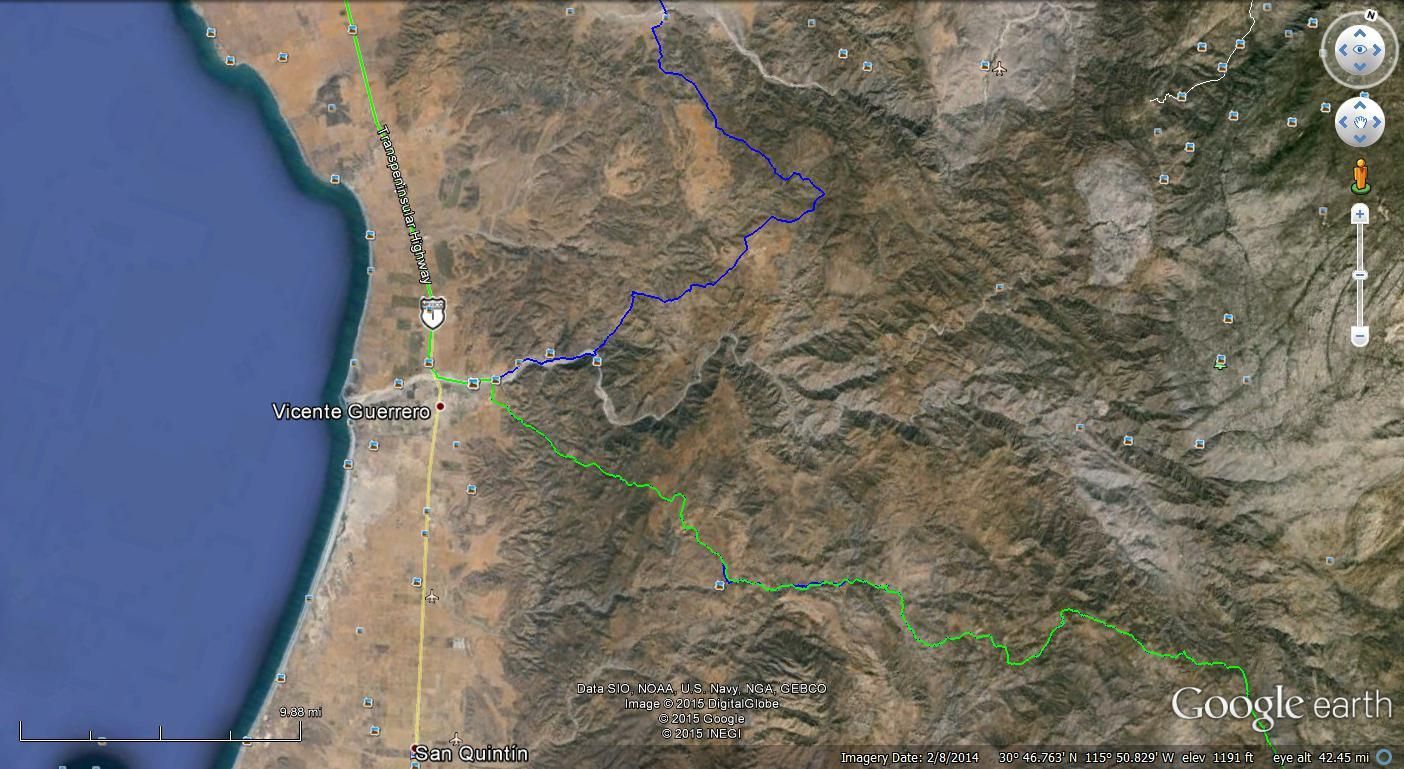
The 07 B1K used the same roads in this area. Below is the 07 B1K in blue and the 13 B1K in green. Part of the bottom blue is covered up by the white
line for a short east/west section.
GE1
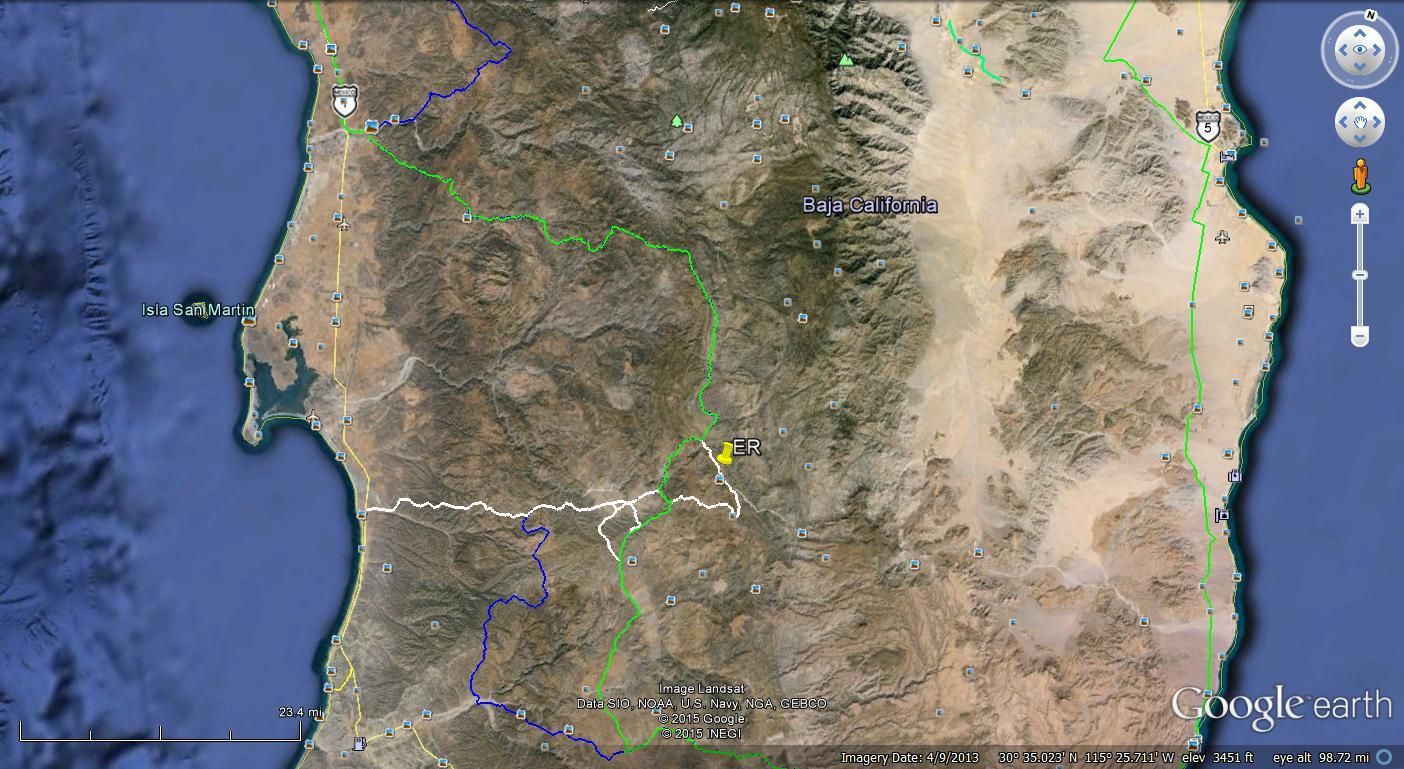
GE2
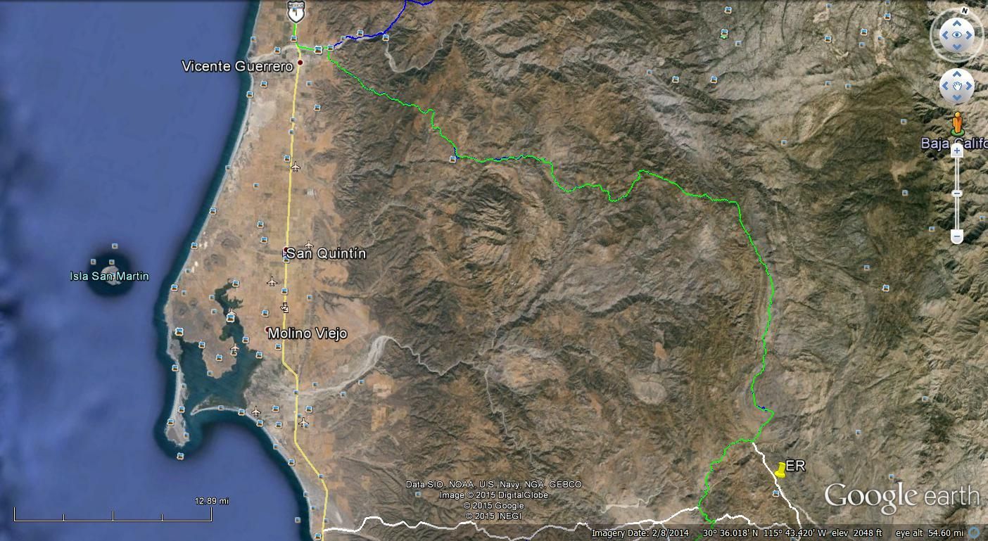
GE3
GE4 Notice the bottom blue and green is using the same section as the 2015 B1K
|
|
|
motoged
Elite Nomad
Posts: 6481
Registered: 7-31-2006
Location: Kamloops, BC
Member Is Offline
Mood: Gettin' Better
|
|
Here are some pics of that area.....for those who may never get out there....
Heading east from the bridge southeast of El Rosario....along farmfields for a bit:


And then southeast up into the hills.....


And starting northwards towards San Quintin....up and over a "pass":


Top of pass looking south:


Time for a break....and some nice vistas....


Cool rain-effects...

Don't believe everything you think....
|
|
|
TMW
Select Nomad
Posts: 10659
Registered: 9-1-2003
Location: Bakersfield, CA
Member Is Offline
|
|
GE4 at the bottom of the blue line where it turns to the right in an arroyo. The road comes to a locked gate at a farm. While I was driving around
looking for a way past it, which I didn't find, someone unlocked the lock so we could get by. There were farm hands in the field working so one of
them unlocked it.
By the way Google Earth does not show the correct path for the road at the farm gate.
|
|
|
bajatrailrider
Ultra Nomad
Posts: 2553
Registered: 1-24-2015
Location: Mexico
Member Is Offline
Mood: Happy
|
|
Ok boys here is what I dont see. GE2 When we leave San Quintine. Going South.Past bridge where Old paved road meets new paved road.Thats where we Go
east,if we go another mile then east.Its old Baja course(We call it rock road) On GE2 map white color road,that crosses green marked road. (going
West)Why you cant see it on map.Start of first road East where two paved roads meet? I know no way to understand me.
|
|
|
TMW
Select Nomad
Posts: 10659
Registered: 9-1-2003
Location: Bakersfield, CA
Member Is Offline
|
|
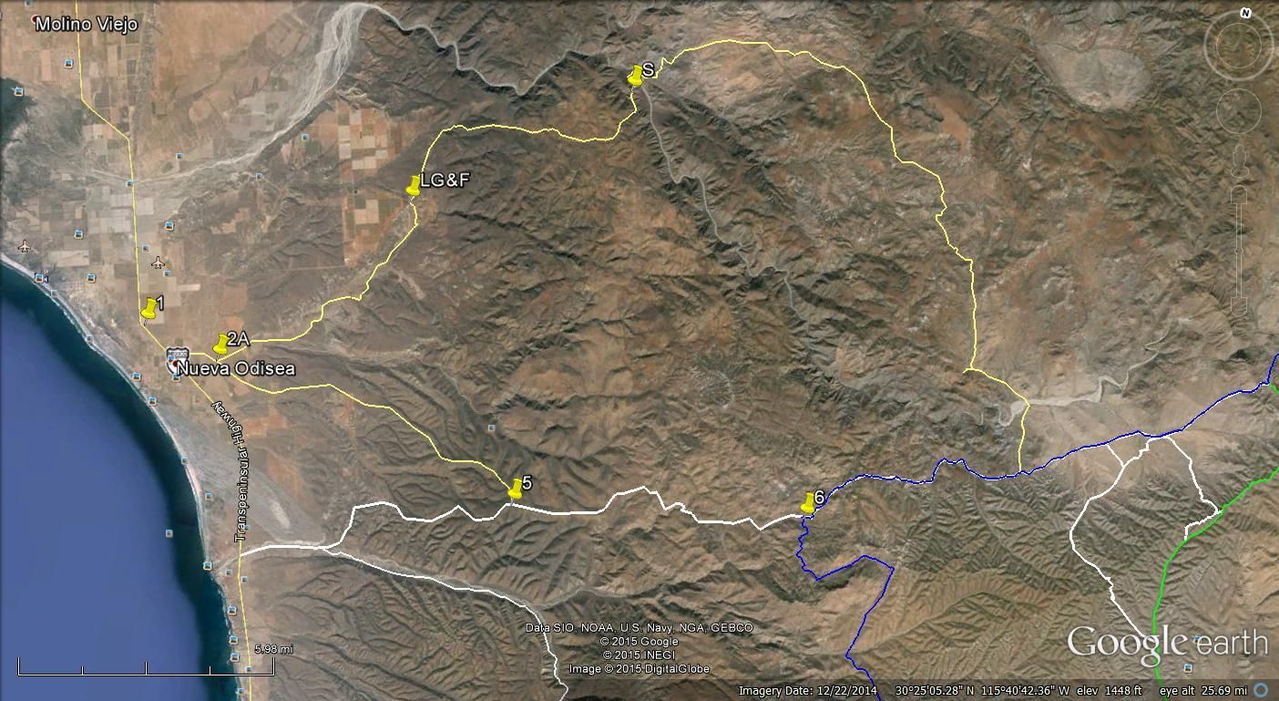
Maybe this will help. Pin 1 is where the the new Hwy and old Hwy join after the tomato farm. Pin 2 is at KM16 and that is where several Baja 1000s
turn toward the mountains.
They would go from 2 to 2A to 3 to 4 to 5 to 6. 5 is where the the white line is in the above GE images. 1 goes NE to a fenced off area we came back
that way once and had to keep going around until we go to 2A. There is a huge hill with switch backs. Let me know if this is what you are looking for
or do I need to go further north.

|
|
|
bajatrailrider
Ultra Nomad
Posts: 2553
Registered: 1-24-2015
Location: Mexico
Member Is Offline
Mood: Happy
|
|
TMW The pin one is the one we like.On the corner you turn Lt on (East) There are huge white tents for growing tomatoes. We are talking same place.We
have not encountered any fences,locked gates.For last 5 years.If you Stray from start of pin 1 north then locked gates.When did you last do this route
TMW. We went this route,Then south last week.
|
|
|
TMW
Select Nomad
Posts: 10659
Registered: 9-1-2003
Location: Bakersfield, CA
Member Is Offline
|
|
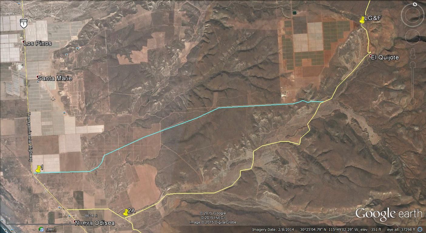
I think the way you went in was OK. We didn't spent a lot of time looking foir another route out. Here is a GE image I did today showing the route we
did about 2 years ago. We went in at KM16 to 2A then over to 5 then 6. The blue line is the 07 B1K, it went south, great ride if you haven't been on
it but a locked gate at the end. However someone opened it for us.
From 6 we followed the 07 B1K to the yellow line going north. It crossed a wide arroyo. There are 2-3 ranchos along the way. We crossed another wide
arroyo before climbing the mountain where there is a shrine at the top (S). From there we went west to LG&F where we met a fence and locked gate.
We went left and south criss-crossing several roads before coming out at 2A.
The Google Earth images for the area are dated 12-22-2014 so they should be pretty accurate.
GE image showing route taken
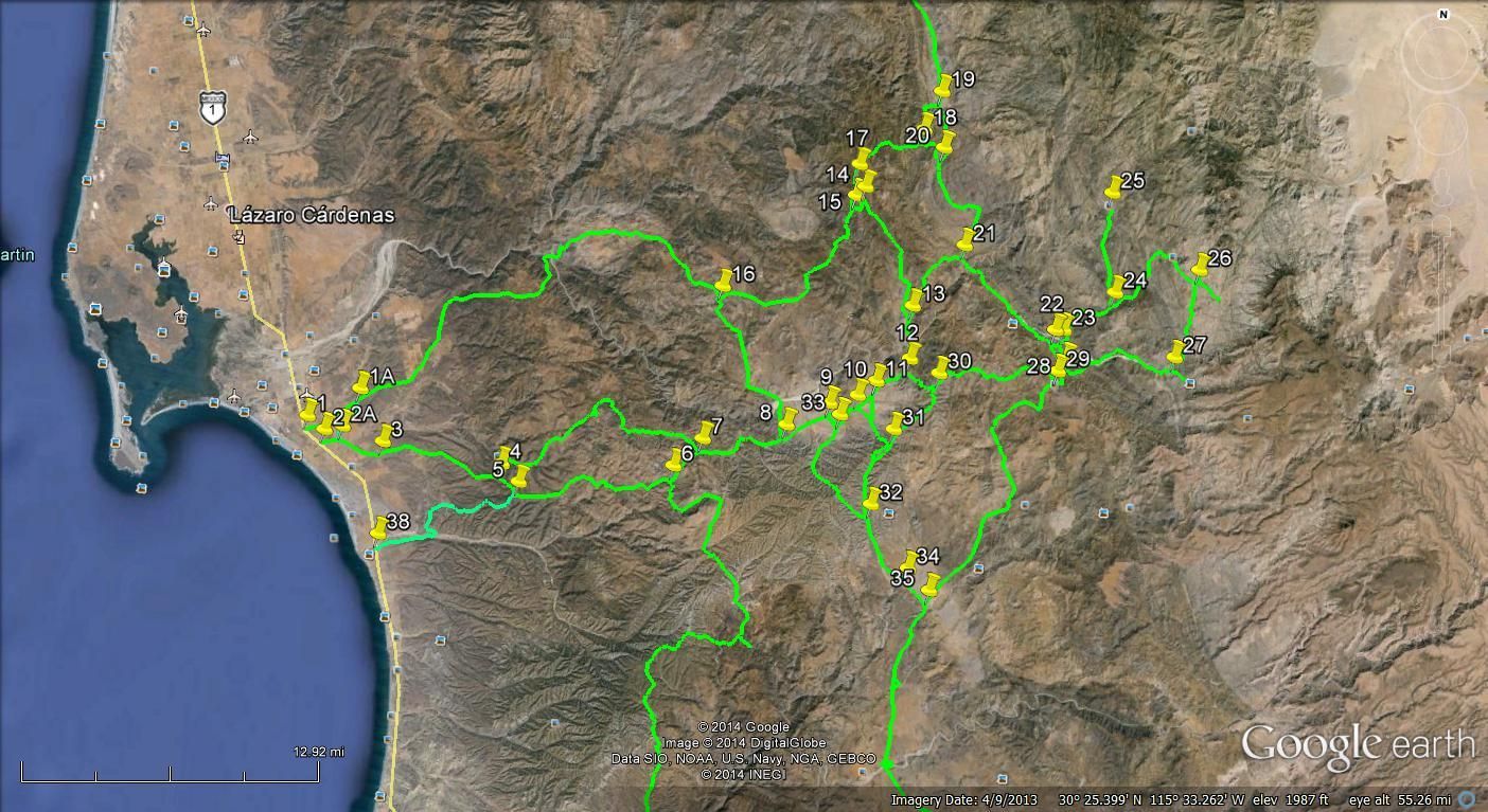
GE image showing the various routes. The numbers relate to coordinates I marked. 19 is where the 07 B1K came down and the 13 B1K went north.
|
|
|
TMW
Select Nomad
Posts: 10659
Registered: 9-1-2003
Location: Bakersfield, CA
Member Is Offline
|
|
This may show the route you took from 1.
|
|
|
bajatrailrider
Ultra Nomad
Posts: 2553
Registered: 1-24-2015
Location: Mexico
Member Is Offline
Mood: Happy
|
|
Tmw this is good view (last map) Do you have one like this from pin1 to Vicente Guerro.We would like to see how many roads,that T or Y in to
route,when it turns North to Vicente.Also how many miles you think,When back all the way east,then starts turn to(north) Vicente.When you went on this
route,From pin one.We get 50 miles east.At foot hills of forest.This is where Danila Ace rancho is located.Few houses,plenty of water,few
trucks,tractor.When you leave her rancho,The side road to Vicente,Rt turn (North ) out there gate.Should be able to see this rancho on Google
Earth.Its in box canyon,Then small road 20ft East of rancho.Its hard 4x4 road,up in forest.We need do 4X4 camp trip up there.She will give us
Permiso.When have been half way up road on bikes. They have two more ranchos on this road up in forest.Thanks for help TMW. Anytime your ready to
wheel up there Im ready.
|
|
|
bajatrailrider
Ultra Nomad
Posts: 2553
Registered: 1-24-2015
Location: Mexico
Member Is Offline
Mood: Happy
|
|
| Quote: Originally posted by motoged | Here are some pics of that area.....for those who may never get out there....
Heading east from the bridge southeast of El Rosario....along farmfields for a bit:
And then southeast up into the hills.....
And starting northwards towards San Quintin....up and over a "pass":
Top of pass looking south:
Time for a break....and some nice vistas....
Cool rain-effects...
Motoged,we did this route few years ago,after rain.Nice and green.What year did you do this ride.Did you ever see anyone back there.Last 5 years,only
few times people on Rancho.Other wise nobody ever.
|
|
|
|
motoged
Elite Nomad
Posts: 6481
Registered: 7-31-2006
Location: Kamloops, BC
Member Is Offline
Mood: Gettin' Better
|
|
BTR,
We did that ride in January 2009....saw no one between EL Rosario and San Quintin....a few fresh bike tracks closer to SQ....the ride up onto the
sand dunes south of SQ and beach ride to SQ was a nice finish to a great ride....
Best rides to you....
Don't believe everything you think....
|
|
|
| Pages:
1
2
3 |


