| Pages:
1
2 |
Gulliver
Senior Nomad

Posts: 651
Registered: 11-18-2013
Member Is Offline
|
|
Mulege to Mulege loop via San Juanico
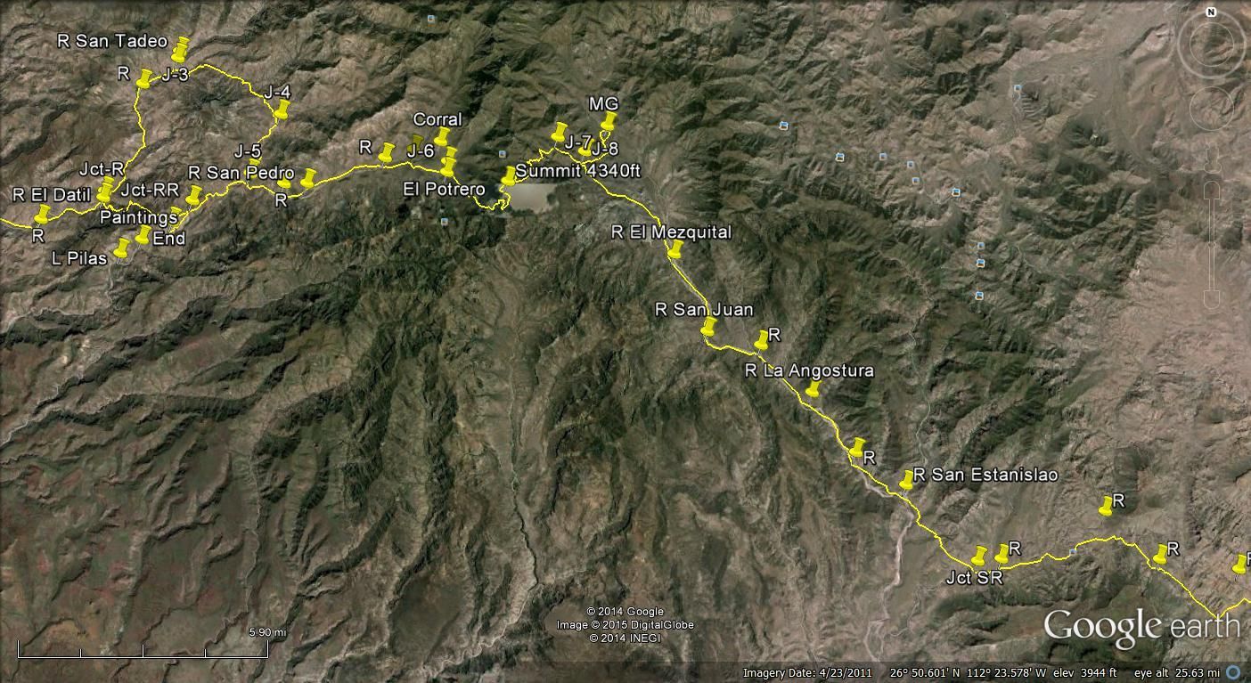
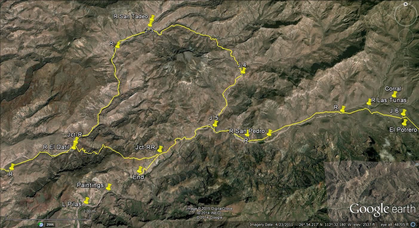
Long overdue info on the Mulege to San Juanico road and back through Purisma to Mulege. Ridden in December of 2015.
First, I will repost the quick guide to getting out of Mulege Westbound without finding yourself in the front yard of every rancho out there.
Starting at Mulege where Ice House road (paved) leaves Rt. 1:
Mile 2.7, Go straight.
Mile 2.8, take the the center road at the three way split.
Mile 3.8, Go straight.
Mile 5.3, Wire gate (please close behind you!)
Mile 5.7, Bear right.
Mile 8.2 Bear right and you are on the old road.
From there it is flat and boring for a while. At about mile 12 or so you pass the gated turnoff to Trinidad where there are cave paintings. They frown
on going there yourself. There are reasonably priced tours from Mulege.
Soon afterwards you enter the foothills of the Sierra Giganta and some of the most fun and beautiful traveling in Baja. Not that demanding and so
pretty especially in the morning with the light behind you.
At around 25 miles you pass the cutoff to Estasnislao and Mission Guadalupe. A nice 15 miles or so with lots of water crossings and river bottom rock
but no way through to San Jose de Magdalena or Los Pilas at this time.
Continue on from the cutoff towards the coast. The sign reads, Ballena 80 km. You are on the West side of the watershed. You will pass any number of
small ranchos. Represito, La Presa, and other anonymous goat farms.
The water crossings are numerous. The ground under the water is firm but there are loose slimy rocks which make life tedious for bikes. The sand on
each side is sometimes deep but kamikaze techniques work. I didnt hit any water deeper than 18. Mostly shallower.
You will come to a Y where the righthand turn heads up a hill to Ballena. Take the left hand fork.
26deg 30.843 W 112deg 30.748 N.
You will go through Ejido Cadeje which is of little interest beyond the startling existence of an airstrip. The road heads up over the hill South
towards San Juanico. This road is wide, flat and invites foolish speeds.
Arrive at San Juanico at 79 miles. Frankly I found it to be wind swept and fly bitten and infested by drunks and surfers (but I repeat myself). With
some time to spare Im sure I could have found more to recommend it.
As noted elsewhere, the maps going South are out of date. Just stay on the pavement and look out of the washouts along the right edge. Not marked
except for an occasional stick.
You will pass Las Barrancas. Dont bother. You will come to a T intersection. Left takes you to Purisma and san Isidro. Both well worth visiting. From
there you either head N.E over the hills to Mulege never to be seen again or continue East through San Isidro and out of town a mile where you can go
sort of straight to Commondu or left up the hill leading you East for the 40 miles to Rt. 1.
This is doable in just about anything if you take your time. The last ten miles are flat and fast.
Then North 40 miles up Rt. 1 and Home for me. 218 miles.
It took me six hours to get to San Juanico. Another five to get home to Mulege. This included perhaps 45 minutes total of munching, peeing, gassing up
and such. I was gobbling Ibuprofen for a couple of days.
|
|
|
motoged
Elite Nomad
Posts: 6481
Registered: 7-31-2006
Location: Kamloops, BC
Member Is Offline
Mood: Gettin' Better
|
|
Most excellent, sir. 
Don't believe everything you think....
|
|
|
BajaBlanca
Select Nomad
Posts: 13247
Registered: 10-28-2008
Location: La Bocana, BCS
Member Is Offline
|
|
those are very detailed directions!
|
|
|
BigBearRider
Super Nomad
Posts: 1299
Registered: 4-30-2015
Location: Big Bear, Punta Chivato, and Cabo
Member Is Offline
Mood: 
|
|
Awesome!
|
|
|
TMW
Select Nomad
Posts: 10659
Registered: 9-1-2003
Location: Bakersfield, CA
Member Is Offline
|
|
Where does the road end if you head toward Guadalupe/las Pilas?
I've been to the painting at las Pilas and know the road is washed out along there. Probably worse now.
|
|
|
Gulliver
Senior Nomad
Posts: 651
Registered: 11-18-2013
Member Is Offline
|
|
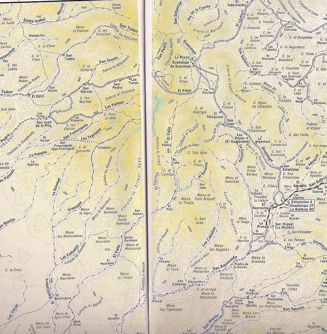
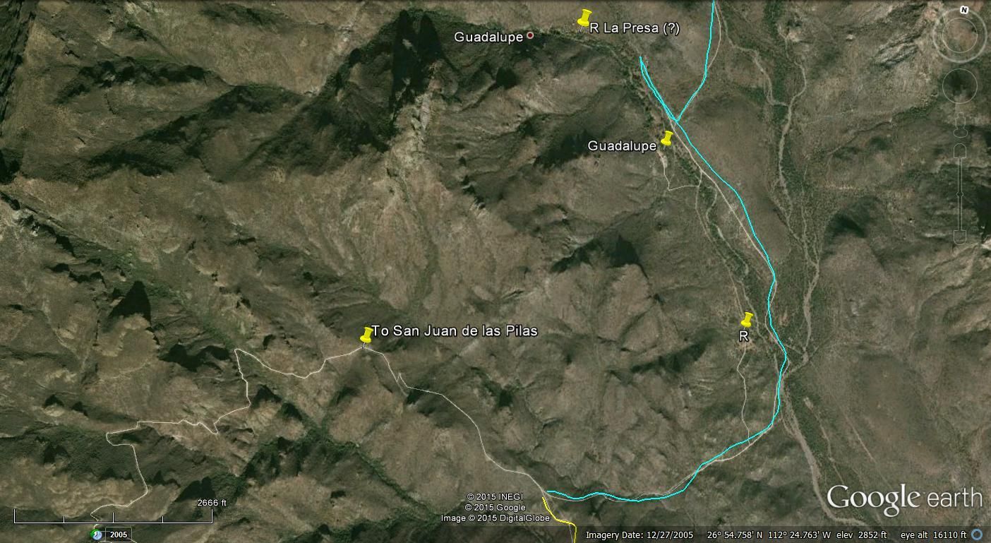
I assume you are asking about the road from La Presa, the last rancho North of Mission Guadalupe, and heading West towards Los Pilas.
I have not explored it from the West end. I have examined it from the East end and it is wiped out right next to Rancho La Presa. The flood came down
right behind the house and there is a channel that is difficult to negotiate on foot much less anything with wheels. Six foot rocks and such. I ride
solo and would not care to get the bike on top of me.
The road beyond the washout looks seldom used but doable. I have little interest in walking so haven't gone up there very far. If I can find a stout
entrenching tool I might do little bushwhacking and create a bypass in which case I will explore further. Some time in January perhaps.
I intend to explore the road West of San Jose de Magdalena today if for no other reason than to marvel at the mess shown in Al's pictures. I will post
the lat/long of the wipeout when I get back. Maybe a picture if it looks any different.
|
|
|
chuck wagon
Newbie
Posts: 11
Registered: 12-5-2015
Member Is Offline
|
|
Great report , I made the trip over and came back the same way a couple of years ago . Still chasing rattles and squeaks in my Wrangler and digging
dust out from hidden places . Worth every rattle though . Took me 7 hours over and 6 back , go figure . CW
|
|
|
Meany
Nomad
Posts: 455
Registered: 2-14-2009
Location: santa paula,calif
Member Is Offline
|
|
Thanks for the report. I Love going that way and seeing all the ranchos.
|
|
|
TMW
Select Nomad
Posts: 10659
Registered: 9-1-2003
Location: Bakersfield, CA
Member Is Offline
|
|
Quote: Originally posted by Gulliver  | I assume you are asking about the road from La Presa, the last rancho North of Mission Guadalupe, and heading West towards Los Pilas.
I have not explored it from the West end. I have examined it from the East end and it is wiped out right next to Rancho La Presa. The flood came down
right behind the house and there is a channel that is difficult to negotiate on foot much less anything with wheels. Six foot rocks and such. I ride
solo and would not care to get the bike on top of me. |
According to the almanac and looking at Google Earth the road that goes to las Pilas turns west before Guadalupe and La Presa. That's the road I am
interested in.
|
|
|
bajajudy
Elite Nomad
Posts: 6886
Registered: 10-4-2004
Location: San Jose del Cabo,BCS
Member Is Offline
|
|
We need a like button. Great report!
|
|
|
Sweetwater
Senior Nomad
Posts: 915
Registered: 11-26-2010
Member Is Offline
Mood: chilly today hot tomale
|
|
Very well done report. Reads like a road rally book.
Everbody\'s preachin\' at me that we all wanna git to heaven, trouble is, nobody wants to die to git there.-BB King
Reality is what does not go away when you stop believing in it. -Philip K Dick
Nothing is worse than active ignorance. Johann Wolfgang von Goethe(1749-1832, German writer, artist and politician)
When choosing between two evils, I always like to try the one I\'ve never tried before. - Mae West
Experience is what keeps a man who makes the same mistake twice from admitting it the third time around.
|
|
|
tiotomasbcs
Super Nomad
Posts: 1837
Registered: 7-30-2007
Location: El Pescadero
Member Is Offline
|
|
Fantastic report and updates. Glad you finally got over your stomach illness. I drove the west to east route thru San Juanico and La Ballena a few
years ago after reading all of these reports. Especially Richards fotos. Took me over six hours, too, Wagonmaster. Keep up the good work fellas.
Smiles. Tomas
[Edited on 12-20-2015 by tiotomasbcs]
|
|
|
MulegeAL
Nomad
Posts: 299
Registered: 8-25-2009
Location: PDX/Mulege
Member Is Offline
|
|
TMW:
The camino you are interested in is hard to find now. I had to scratch around in the bushes to find it. But it is there, sorta.
It is not passable with 4 wheels anymore, due to large rockfall, gully erosion, and lack of use. The rancheros on the west side travel it by mule
now. I don't think I'd take my quad there due to tight spots around boulders, it is enough of an adventure on a good bike!
I went to the paso and a bit beyond by moto but didn't drop in to El Protrero 'cause I was solo and there is mucho loose rock on the steep climb back
out. The climb was moderately tough, meaning much loose rock/eroded roadbed, no mistakes allowed up or down. As I recall, it took me almost as long
to do the 3 mile climb from valley floor to the pass as it did to get to the start of the road from Mulege. That was March '015.
I was pooped when I got back down, took a break, met two senoras out gathering firewood for the Guadelupe rancho. Turns out one of them is daughter
of our groundskeeper in Mulege, small world! Had her senior take a picture to show her dad. She had to show her how to use a pocket camera, had
never used or seen one before. Only in baja, that made my day right there.
Beyond San Marcos the road is gone total since hurricane Paul. Some real tough riders have reportedly come through from El Datil, I haven't done that
yet. There is some info on this in ADVrider trip reports, but sketchy, they were real busy just getting through, and finally got to Mulege about
930/10 at night. That was before Odile, which did more damage than Paul because of more/longer water flow time.
Say hi to Felix at El Datil! Cool canyon, above it, would like to go back there, but not solo. Anything east of El Datil/San Juan de La Pila: bring
your A-game.
I am somewhat reluctant to post on this stuff because there is no way to describe how rough and unforgiving this remote part of baja can be, and I
would hate to see riders go out there and get hurt/busted based on my descriptions of degree of tough.
It is tough on riders and equipment, requires a lot of prior experience with riding very rough unforgiving hot remote no-shade terrain, not crashing,
knowledge of repair/self-rescue techniques.
Can't wait to go back!
|
|
|
TMW
Select Nomad
Posts: 10659
Registered: 9-1-2003
Location: Bakersfield, CA
Member Is Offline
|
|
Thank you, that gives me a better ideal of the area coupled with Gulliver's report. I'd like to go back in there to see the damage. Some of the
pictures are amazing.
|
|
|
Gulliver
Senior Nomad
Posts: 651
Registered: 11-18-2013
Member Is Offline
|
|
Al, I had no idea that road was there cutting off South of Mission Guadalupe. That's a real game changer for me. I must have gone past it mucho times
leading visiting firemen up there.
I will do some Google Earth crawling and see if I can find it.
Get done with your new yacht and get down here. By the time you get here I will be nothing but gristle and red corpuscles.
[Edited on 12-21-2015 by Gulliver]
|
|
|
Gulliver
Senior Nomad
Posts: 651
Registered: 11-18-2013
Member Is Offline
|
|
I need someone familiar with Google Maps to lead me by the nose a bit.
Is there a way to identify a location by lat/long? Like click on some spot and have Maps tell where it is? Or type in a lat/long and have Maps center
on it? My marine nav programs work that way.
Or am I wasting my time with Google Maps?
Most of the programs I have fooled with have reasonable satellite imagery but no way to get a road intersection lat/long in numbers so I can enter it
as a way point in my GPS. Useless.
|
|
|
TMW
Select Nomad
Posts: 10659
Registered: 9-1-2003
Location: Bakersfield, CA
Member Is Offline
|
|
If you just move the cursor around it shows the long. and lat. Where ever the cursor is the long. and lat. are shown in the lower right of the screen
as well as the date the image was made. Look above at the Google Earth images and look mat the bottom right. They represent where the cursor is.
|
|
|
TMW
Select Nomad
Posts: 10659
Registered: 9-1-2003
Location: Bakersfield, CA
Member Is Offline
|
|
Google Earth does not always have the latest image map. Bing is usually newer. Go to http://www.flashearth.com/ if you left click and drag the center crosshair gives you the Long. and Lat. in Hours-Minutes and Seconds.
|
|
|
David K
Honored Nomad
Posts: 65492
Registered: 8-30-2002
Location: San Diego County
Member Is Offline
Mood: Have Baja Fever
|
|
The elevation is also shown.
|
|
|
MulegeAL
Nomad
Posts: 299
Registered: 8-25-2009
Location: PDX/Mulege
Member Is Offline
|
|
Gully, check out an adv thread called "geospatial/georeferanced pdfs". Is in the pnw regional forum.
I have the waypoint you want. I'll see if I can get my old GPS to cough it up.
It's hard to find cause pickups don't track it anymore. It crosses a small arroyo then climbs to a gate. Find that and you are on your way.
|
|
|
| Pages:
1
2 |


