| Pages:
1
2 |
Gulliver
Senior Nomad

Posts: 651
Registered: 11-18-2013
Member Is Offline
|
|
San José de Magdalena to Mission Guadalupe, NOT!
12-20-2015
As I was resting at the San José de Magdalena cemetery this afternoon on the way back out, I was reminded of a statement that Meriweather Lewis (of
Lewis and Clark fame) made in recounting their first encounter with a grizzly bear. After relating how the party had been scattered and chased hither
and thither and into the river by the bear, he said, Weve pretty much satisfied out curiosity on this subject. Thats the way I feel about this
road.
For those of you who want the short and sweet, I didnt even get as far as those wonderful pictures of the washout. Things have not improved at all.
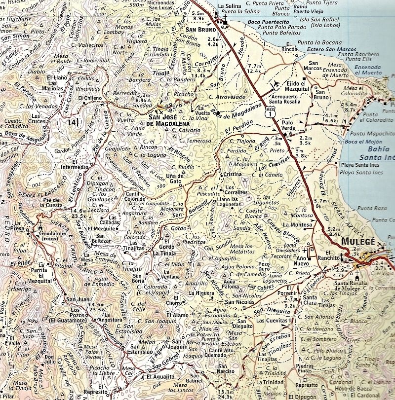
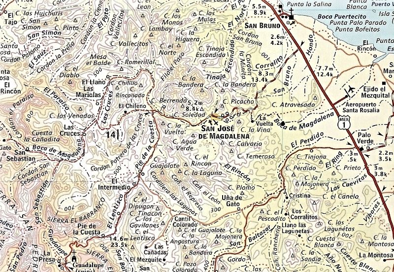
The eight miles of paved road from Rt. 1 to Magdalena can be negotiated in a stretch limo. Odometer set to zero at the Magdalena cemetery.
Bump on through town. Make a right after you cross the water. If you dont, you will end up in the town square. No biggy but not that interesting.
The road through town is about what you will be dealing with for most of the next hour. Want to turn back?
5.8 miles. Make a left at the Y. Where the road to the right goes, I dunno. Another trip some day.
Follow your best instincts to Rancho San Isidro. 10.9 miles. Say hello to Veronica, the nice young lady there who said that the road was Muy Malo and
ended Mucho Lejos down the road. Hmm.
13.2 miles. Gate. Close it behind you.
The canyon walls start to close in. The decent bits of old road are fewer and further apart. The rocks get bigger and looser. The evidence of wheeled
travel gets much, much scarcer. I begin to hear banjos.
The end (for me at least). 26 deg., 56.83N 112 deg., 21.948W About 16.6 miles. One could hike on through if you were nuts.
I fell over twice just trying to walk the bike through the bowling ball sized lumps interspersed with ledges and sand pockets and worse. I was riding
solo and got my foot stuck under the bike once. I walked ahead a few hundred feet and it got worse. The Summer rains have just removed anything
looking like a road. Enough.
It is a fun ride up until the last mile. The scenery is nice and the people are friendly. The various ranch hands I encountered said that they were
pretty sure the road would never be repaired. No one had even ridden a mule through in a long while.
Enjoy,
Mike
[Edited on 12-21-2015 by Gulliver]
|
|
|
mcnut
Nomad
Posts: 177
Registered: 12-9-2013
Location: Dammeron Valley, UT
Member Is Offline
|
|
Thanks so much for the fine report, I also miss the loss of this loop to the point of wanting to try connecting the route S of Magdalena which passes
through Una de Gato. Palo Verde to El Intermedio, I think DavidK has explored the E end.
Anyone ever tried connecting through?
Bruce
|
|
|
MulegeAL
Nomad
Posts: 299
Registered: 8-25-2009
Location: PDX/Mulege
Member Is Offline
|
|
Did that twice in March, through una de gato. West of the Rancho is rough & twisty.
|
|
|
Gulliver
Senior Nomad
Posts: 651
Registered: 11-18-2013
Member Is Offline
|
|
I probably went right past that road when I was going through Intermedio yesterday. Another day trip on the list.
As I mentioned in the report, just before I came to Intermedio, I stopped at Rancho San Isidro which is not labelled on my Almanac page. Big buildings
with a large mess hall all set waiting for the lunch crowd of Vaqueros to arrive. Very prosperous looking.
My turn around point coincides with Pie de la Cuesta on my map. There is a small concrete building with a fenced enclosure there but no sign of recent
use.
|
|
|
mcnut
Nomad
Posts: 177
Registered: 12-9-2013
Location: Dammeron Valley, UT
Member Is Offline
|
|
Quote: Originally posted by Gulliver  | | I probably went right past that road when I was going through Intermedio yesterday. Another day trip on the list. |
There is also a dead-end fork to the south of Una de Gato which looks to lead to some interesting ranchos, terrain and petroglyphs.
Bruce
[Edited on 12-21-2015 by mcnut]
|
|
|
Gulliver
Senior Nomad
Posts: 651
Registered: 11-18-2013
Member Is Offline
|
|
O.K., I get the message. It's bumped up the list. (grin)
|
|
|
mcnut
Nomad
Posts: 177
Registered: 12-9-2013
Location: Dammeron Valley, UT
Member Is Offline
|
|
Just need to use the right bait!
Bruce
|
|
|
David K
Honored Nomad
Posts: 65565
Registered: 8-30-2002
Location: San Diego County
Member Is Offline
Mood: Have Baja Fever
|
|
Overall + Zoom Maps
2009 Almanac:
2010 AAA:
|
|
|
David K
Honored Nomad
Posts: 65565
Registered: 8-30-2002
Location: San Diego County
Member Is Offline
Mood: Have Baja Fever
|
|
| Quote: Originally posted by mcnut | Thanks so much for the fine report, I also miss the loss of this loop to the point of wanting to try connecting the route S of Magdalena which passes
through Una de Gato. Palo Verde to El Intermedio, I think DavidK has explored the E end.
Anyone ever tried connecting through?
Bruce |
My travel in that area is limited to the road from Palo Verde west to El Perdido, then across the huge arroyo north to find the El Camino Real road
north to La Magdalena ruins then on to the road from the goat ranch back to Hwy. 1 north of the long bridge. On my Almanac map above, I put a black
dot where La Magdalena is touching the word Boca on the arroyo. That was in 2009. Then we returned last July going in and out to La Magdalena on the
goat ranch road (shown as small red dots) north of the airport road.
Mike: Thanks for the post and report up from San José de Magdalena! In my new book, I put in the road was impassable, and that doesn't need an edit
with your research confirming conditions.
|
|
|
KurtG
Super Nomad
Posts: 1211
Registered: 1-27-2004
Location: California Central Coast
Member Is Offline
Mood: Press On Regardless!!
|
|
| Quote: Originally posted by Gulliver | I probably went right past that road when I was going through Intermedio yesterday. Another day trip on the list.
As I mentioned in the report, just before I came to Intermedio, I stopped at Rancho San Isidro which is not labelled on my Almanac page. Big buildings
with a large mess hall all set waiting for the lunch crowd of Vaqueros to arrive. Very prosperous looking.
My turn around point coincides with Pie de la Cuesta on my map. There is a small concrete building with a fenced enclosure there but no sign of recent
use. |
That's the ranch I referred to in a previous post. Really nice family. Veronica's mother Elsa is the cheesemaker. If you're back there ask them to
show you around which they are happy to do. I hope to be in Mulege in January and will be visiting the ranch then.
|
|
|
Gulliver
Senior Nomad
Posts: 651
Registered: 11-18-2013
Member Is Offline
|
|
My Spanish is pretty primitive but she did communicate to me that she had gone to the preparatory (high school?) in Mulege.
I thought it was a restaurant at first. A little off of the major spice routes, so to say.
|
|
|
KurtG
Super Nomad
Posts: 1211
Registered: 1-27-2004
Location: California Central Coast
Member Is Offline
Mood: Press On Regardless!!
|
|
| Quote: Originally posted by Gulliver | My Spanish is pretty primitive but she did communicate to me that she had gone to the preparatory (high school?) in Mulege.
I thought it was a restaurant at first. A little off of the major spice routes, so to say. |
That open roofed in area connects the modern living quarters and kitchen to the left and the old adobe structure to the right. Elsa is a great cook
and the old kitchen with its open oven is the most used. Their cheese is sold mostly to markets in Santa Rosalia and they also make dulce de leche
which is sold there as well.
A few years ago I and friends had a Christmas day meal there which started with the early morning butchering of the goat that was served up later.
I grew up on a farm in northern Minnesota and amazed the family by showing that I could indeed milk a cow, they didn't think any Gringos had that
skill. My Spanish is also very limited but I always carry a dictionary and notepad and we manage to communicate.
|
|
|
MulegeAL
Nomad
Posts: 299
Registered: 8-25-2009
Location: PDX/Mulege
Member Is Offline
|
|
| Quote: Originally posted by David K |
Then we returned last July going in and out to La Magdalena on the goat ranch road (shown as small red dots) north of the airport road.
|
So, sounds like the little red dot road is bulldozed through again and you could drive through to the new pavement? That would be good news.
It was basketball-sized boulder field in March/April. I had a lot of trouble past the lower rancho that is up on the eastern bank at the end of the
old irrigation ditch. The flood destruction/material movement there is incredible.
|
|
|
David K
Honored Nomad
Posts: 65565
Registered: 8-30-2002
Location: San Diego County
Member Is Offline
Mood: Have Baja Fever
|
|
| Quote: Originally posted by MulegeAL | | Quote: Originally posted by David K |
Then we returned last July going in and out to La Magdalena on the goat ranch road (shown as small red dots) north of the airport road.
|
So, sounds like the little red dot road is bulldozed through again and you could drive through to the new pavement? That would be good news.
It was basketball-sized boulder field in March/April. I had a lot of trouble past the lower rancho that is up on the eastern bank at the end of the
old irrigation ditch. The flood destruction/material movement there is incredible. |
Did not see or try to get to the San José de Magdalena highway from Boca de Magdalena/ Los Pozos goat ranch. Here is that part of my trip report, last
July:
I want to check on the Magdalena mission-era site we visited in 2009 that is a few miles northwest of Mulegé. It remains unclear who or when the
project was built. Why it was out in the desert and not in the oasis valley where the water is (todays town of San José de Magdalena) is also
strange. Some maps show the site, but not exactly located, as Santa María Magdalena (a proposed Jesuit mission, but much farther north). The Mulegé
mission was almost moved to this location after floods destroyed that missions fields in 1770.
The site is at the end of a long aqueduct carved into the side of a cliff and across the desert to a pila (reservoir). Stone, rock and adobe building
ruins are nearby
or were. This was an important site, but forgotten by time and in a harsh location, rarely seen by outsiders.
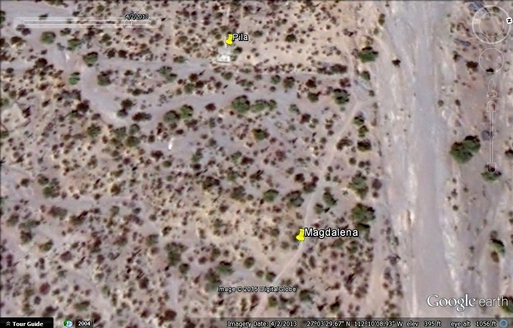
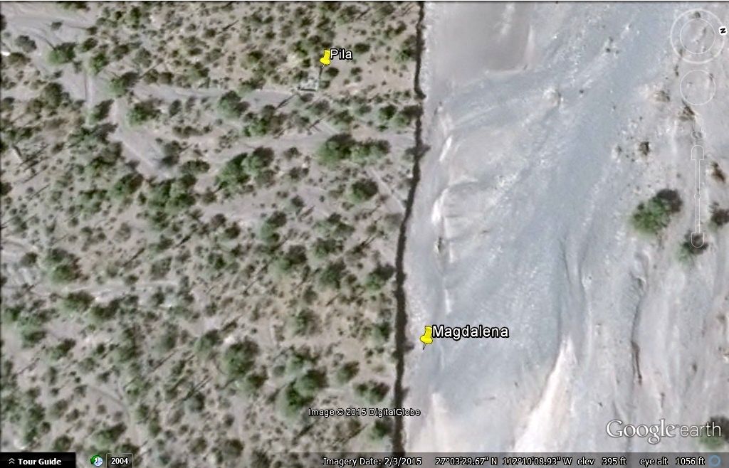
Google Earth images show that the Magdalena riverbed widened during a hurricane after our 2009 visit, and took out the building location, but not the
pila (yet). The buildings, on both sides of a dirt road were centered at GPS: 27°03'29.9" -112°10'07.4" and the pila nearby (we didnt go see in 2009)
is at: GPS: 27°03'29.1" -112°10'12.3"
What inspired me to investigate was to see if indeed another historic site was washed away, like at Mission Ligüí in 2001, and document what may
remain before it too is gone forever.
Here is that satellite images before (2012) and after (2015) the flash flood event. Markers at the building and pila sites:


CLOSER (and west at top):
On 4-2-13:
On 2-3-15:
Just north of the series of bridges, past the Palo Verde airport road, we turn left (west) off of Hwy. 1 just north of Km. 162 (0.4 mile south of Km.
163 if southbound). Some of this dirt road was used recently for an off road race, many arrow signs. Set odometer to 0.
0.0 Hwy. 1 (Km. 162 ½ )
0.4 Fork, go left (southwest).
3.7 Drive out onto riverbed cobble.
Road goes west about ¼ mile, then turns south, crosses water to south side and turns back east passing goat ranch area. See aqueduct along cliff that
terminates at the Magdalena mission-era pila, hidden in the desert.
4.4 fork left off ranch road (ends ahead at blue ranch house) into arroyo bed, soon pass by blue house while driving east in arroyo.
4.8 Park by side gully on south wall of arroyo. Walk south in gully and see pila on right. Walk east from pila to see remains of melted adobe walls
next to new cliff, overlooking wide arroyo.
[Edited on 12-22-2015 by David K]
|
|
|
motoged
Elite Nomad
Posts: 6481
Registered: 7-31-2006
Location: Kamloops, BC
Member Is Offline
Mood: Gettin' Better
|
|
MulegeAl took me up there by moto two years ago....along that rocky riverbed. We rode west out of the village of Magdalena several miles and took a
fork that led southerly and then easterly back to the highway....through several ranchos (one with significant solar set-up if my memory works).
There seemed to be some significant roadwork being done in the area where we rode back out to the highway (south of entrance to rocky
riverbed....which was south of paved road to Magdalena).
MulegeAl can describe this area better than I can.....
Don't believe everything you think....
|
|
|
mcnut
Nomad
Posts: 177
Registered: 12-9-2013
Location: Dammeron Valley, UT
Member Is Offline
|
|
The western end of the Gato route used to look very primitive but I think since the main route washed out it might see more use (only based on GE
images) now.
Bruce
|
|
|
Pescador
Ultra Nomad
Posts: 3587
Registered: 10-17-2002
Location: Baja California Sur
Member Is Offline
|
|
You can go to the Rancho described in the stories and just past you can come back through Una de Gato and return to the road going to the cave
paintings. If you try to go past the ranch and continue on the main road you will come to the canyon where we used to go to see Zalate Trees growing
up the side of the canyon and it is full of house sized boulders. A road crew went up there with blasting powder, D-8 Cats, and finally gave up and
figured that they would never again open that section of road. We used to run up to the Mission a lot but the Hurricane a couple of years ago knocked
out that canyon so I doubt that connection will ever open again.
|
|
|
David K
Honored Nomad
Posts: 65565
Registered: 8-30-2002
Location: San Diego County
Member Is Offline
Mood: Have Baja Fever
|
|
Any photos at the mission you can share Pescador? Thank you!
|
|
|
Gulliver
Senior Nomad
Posts: 651
Registered: 11-18-2013
Member Is Offline
|
|
Yesterday afternoon the guys at the bike shop confirmed that they are going to ride up to Mission Guadalupe the first weekend in January. I'll be with
them and will take pictures. It's only 40 miles from town on a fairly decent road.
|
|
|
David K
Honored Nomad
Posts: 65565
Registered: 8-30-2002
Location: San Diego County
Member Is Offline
Mood: Have Baja Fever
|
|
Awesome... I hope to compare the location today with what Max saw in 1996


|
|
|
| Pages:
1
2 |


