| Pages:
1
2 |
5oclocktrek
Newbie
Posts: 10
Registered: 1-17-2016
Member Is Offline
|
|
hwy1 to puerto charle road info
was wondering if the new last year PAVED road goes all the way to PUERTO CHARLIE on the west coast or if it falls short as per usual mex road work????
also, are there good camp spots/ocean access for a 25ft rv??
|
|
|
Mula
Super Nomad
   
Posts: 1664
Registered: 8-16-2011
Location: San Nicolas y Lopez Mateos
Member Is Offline
|
|
The road is NOT paved all the way out to Puerto Chale.
|
|
|
David K
Honored Nomad
        
Posts: 65436
Registered: 8-30-2002
Location: San Diego County
Member Is Offline
Mood: Have Baja Fever
|
|
Where's Puerto Chale you ask?
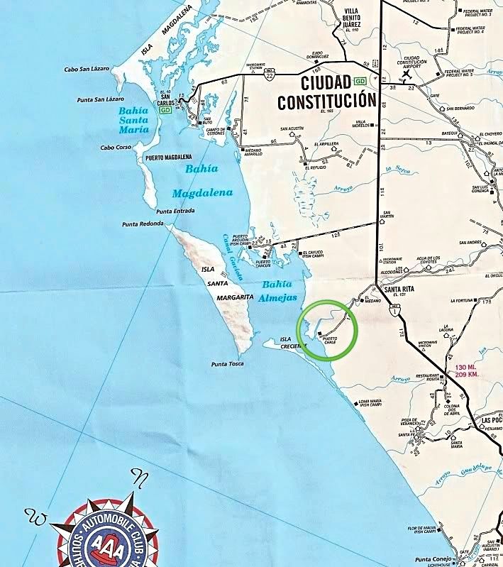
14.2 miles from Hwy. 1 at Santa Rita.
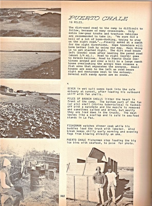
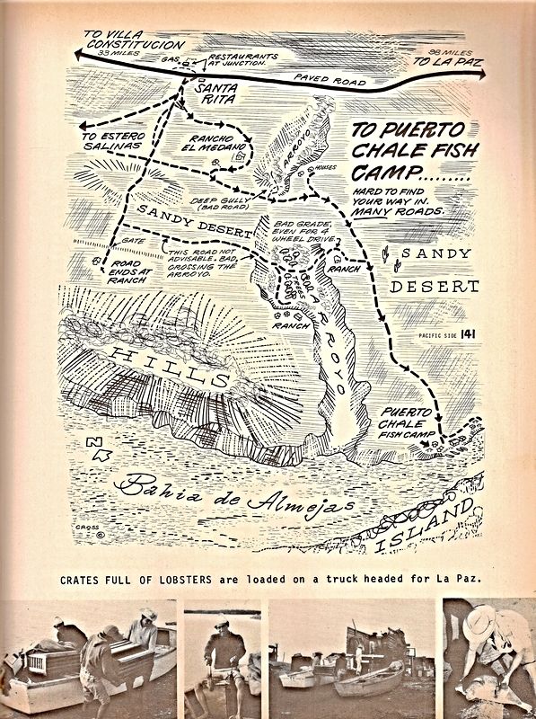
Back in 1970 (Cliff Cross Baja Guide):
|
|
|
5oclocktrek
Newbie
Posts: 10
Registered: 1-17-2016
Member Is Offline
|
|
thanks for the info, any idea how far in it is paved?
|
|
|
StuckSucks
Super Nomad
   
Posts: 2374
Registered: 10-17-2013
Location: Pacific Plate
Member Is Offline
|
|
As of a year ago, the road was paved maybe 2/3 of the way to the coast. I didn't have the time to get out there (too busy doing prerun things).
The turnoff at Santa Rita to Pto. Chale is at km157 - been there many many many times.
|
|
|
David K
Honored Nomad
        
Posts: 65436
Registered: 8-30-2002
Location: San Diego County
Member Is Offline
Mood: Have Baja Fever
|
|
Is there a bridge or just a vado where that big arroyo is crossed?
|
|
|
StuckSucks
Super Nomad
   
Posts: 2374
Registered: 10-17-2013
Location: Pacific Plate
Member Is Offline
|
|
As I recall, nothing more than an up/down spot on the road.
|
|
|
Mula
Super Nomad
   
Posts: 1664
Registered: 8-16-2011
Location: San Nicolas y Lopez Mateos
Member Is Offline
|
|
Talked to some people today who have property in Puerto Chale . . . They say the road is paved all the way out to Puerto Chale . . . .and they are
building a new sport fishing dock and harbor there.
Progress?
|
|
|
5oclocktrek
Newbie
Posts: 10
Registered: 1-17-2016
Member Is Offline
|
|
Thanks again for all the info, hope someone who has driven out there in the last few months will add some comments.
also wondering about camping areas for a 25 ft mtr home and access to the water for boat/kayak.
is there beach there or mainly mangroves??
|
|
|
toronja
Nomad
 
Posts: 134
Registered: 2-1-2015
Location: Eugene, OR
Member Is Offline
|
|
We went out two years back, so I can't comment on the current road status. It would definitely be an odd place to camp with a motor home, though. Very
small town on a tidal inlet with a ton of mangroves, certainly off the beaten path for all that the road is paved. I don't remember there being much
in the way of beaches, but we didn't do a lot of exploring. You could certainly get kayaks in and out at the panga launch, if not elsewhere, just
watch the tides or you'll be wading through mud for awhile. The people were absolutely lovely. We ran into a local fisherman, Gumbercinto, who had
excellent English skills (he lived in Oregon for ~10 years).
|
|
|
StuckSucks
Super Nomad
   
Posts: 2374
Registered: 10-17-2013
Location: Pacific Plate
Member Is Offline
|
|
Here's a photo sphere I took 15km southwest of Santa Rita, next to said paved road.
https://goo.gl/maps/BgDZLKoJCCx
|
|
|
5oclocktrek
Newbie
Posts: 10
Registered: 1-17-2016
Member Is Offline
|
|
more good info!!!
still hoping for more 2016 rd info on if pavement does go all the way.
also camping spots???
|
|
|
Desertbull
Senior Nomad
  
Posts: 558
Registered: 8-27-2003
Member Is Offline
|
|
I was out there last week and its paved all the way to town. Camp to the south of town, their are a few sand based roads that are hard enough for you
to get towards the water south of town...but you could also go to south to Punta Marquez which is paved as well and ocean front easy access camping
for a motorhome. Check it out on the map...Enjoy
DREAM IT! PLAN IT! LIVE IT!
|
|
|
5oclocktrek
Newbie
Posts: 10
Registered: 1-17-2016
Member Is Offline
|
|
I can not find punta marquec on my map
how do you get to it from Puerto charle??
|
|
|
StuckSucks
Super Nomad
   
Posts: 2374
Registered: 10-17-2013
Location: Pacific Plate
Member Is Offline
|
|
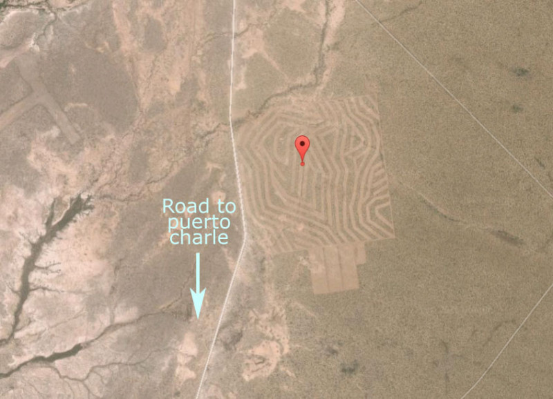
Crop circles in Baja? This is ~13km southwest of Santa Rita, east of the Puerto Charle Road. A giant thumb print? What's going on?
https://goo.gl/maps/sjjAerim27J2
|
|
|
David K
Honored Nomad
        
Posts: 65436
Registered: 8-30-2002
Location: San Diego County
Member Is Offline
Mood: Have Baja Fever
|
|
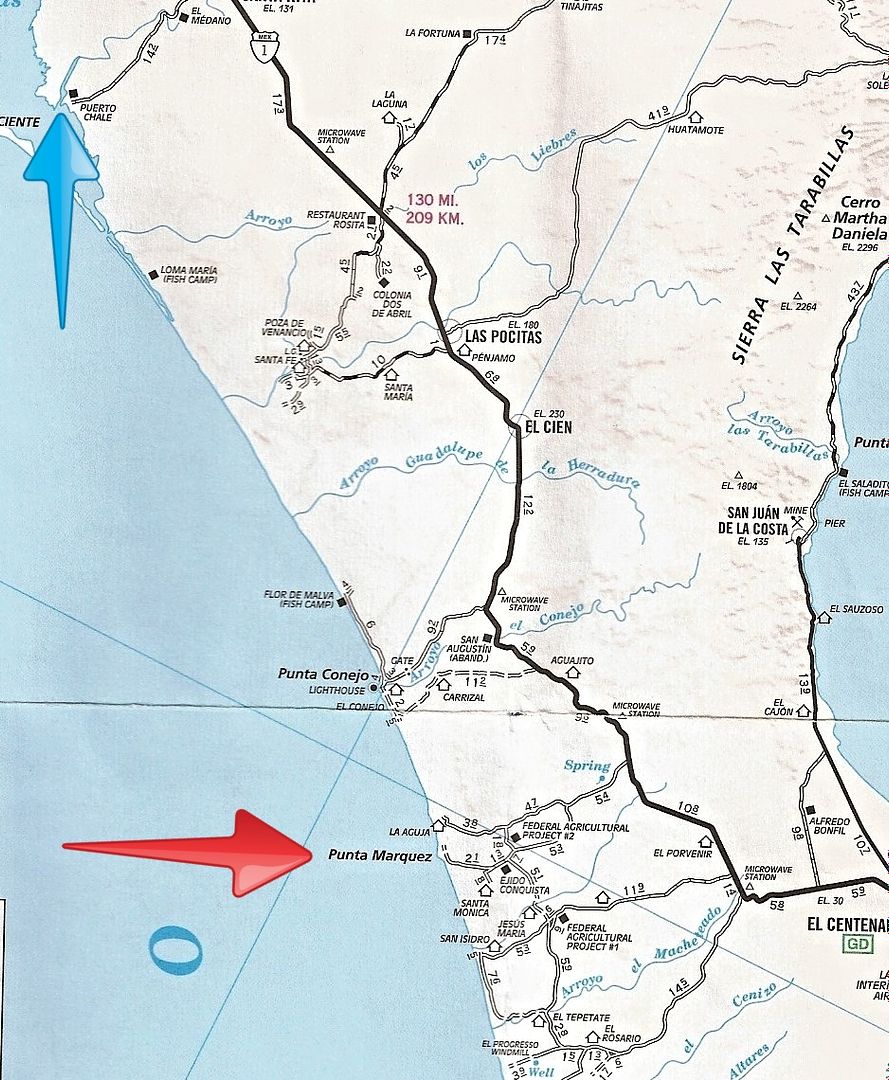
Punta Marquez?
That is much further south, about 100 miles... access road is about 30 miles northbound from La Paz.
It is on the AAA map and the Baja Almanac map, but spelled Marquez.
|
|
|
5oclocktrek
Newbie
Posts: 10
Registered: 1-17-2016
Member Is Offline
|
|
Thanks for all the info - I was hoping puerto charle would have had better beach camping as on the map it looked like a somewhat sheltered area to
kayak and zodiac in/at.
puenta marquez sounds like better beach camping but looks quite open coastline and exposed waters.
we just came into la paz from 2 weeks of very windy beach camping at tecolote. did get a few days decent enough to get out to islas esperito and did
manage to catch 2 nice sized jack crevaile!!good fighters
just got an email from some people we met camping at tecolote, they winter in lopez mateos and had stoped at Puerto charle on the way home.they called
it a shanty town. different strokes for different folks!!!
|
|
|
David K
Honored Nomad
        
Posts: 65436
Registered: 8-30-2002
Location: San Diego County
Member Is Offline
Mood: Have Baja Fever
|
|
We camped at Punta Conejo, which is between Chale and Marquez, and closer to Hwy. 1 than the other two. Huge beach, freindly fishermen at the nearby
campo, and tons of hermit crabs in the morning!
That was in 1985... I wonder what it looks like now?
|
|
|
cliffh
Nomad
 
Posts: 325
Registered: 1-23-2010
Location: buena vista, BCS
Member Is Offline
|
|
Conejo is a great spot to camp and watch the Score races and local races come through, we usually stay 6 to 10 days. I am guessing the score 500 baja
sur will go through there in april. We will be there on the bluff Prowler 5th wheel.
|
|
|
5oclocktrek
Newbie
Posts: 10
Registered: 1-17-2016
Member Is Offline
|
|
punta canejo sounds nice, I believe it is still a snd/gravel road in.
what/where are the good maps shown above from??
much better than the POS NATIONAL GEOGRAPHIC MAPS I HAVE!!!
as we all know much has changed in the Baja since 1985 plus we all have a few more years/miles on us since then, sure wish we could reverse the
clock!!!!
|
|
|
| Pages:
1
2 |

