| Pages:
1
2
3 |
WideAngleWandering
Nomad

Posts: 416
Registered: 3-13-2012
Location: US-Based but traveling
Member Is Offline
|
|
Road to Rancho El Coyote in a stock cherokee?
I'm planning my upcoming Baja trip and was thinking about going to San Pedro Martir via Mike's Sky Ranch and Rancho Coyote. I've driven this road in
fall 2011 in my lifted '84 Landcruiser on 33s and it was a fun drive.
However, my buddy who is following will be driving his girlfriend's 2011 Grand Cherokee Overland w/ adjustable ride height ( it a 4.1 inch lift) on
stock tires. He's a good wheeler but I think the tires would be a problem on this trail.
What's the road condition like today? Would we thrash his girlfriend's car if we do this? She'll be riding shotgun and would bear direct witness to
our foolishness.
Traveling the Americas via my old land cruiser
|
|
|
motoged
Elite Nomad
Posts: 6481
Registered: 7-31-2006
Location: Kamloops, BC
Member Is Offline
Mood: Gettin' Better
|
|
Take her car....discourage her from attending....send her a postcard from Ensenada....
Don't believe everything you think....
|
|
|
ehall
Super Nomad
Posts: 1906
Registered: 3-29-2014
Location: Buckeye, Az
Member Is Offline
Mood: It's 5 o'clock somewhere
|
|
Haven't been on the west road in a few years but tried the east road in January. Had to turn around about 7 miles in because the off camber shelf
road was washed out. I was in a tj rubicon on 35's.
|
|
|
AKgringo
Elite Nomad
Posts: 6358
Registered: 9-20-2014
Location: Anchorage, AK (no mas!)
Member Is Offline
Mood: Retireded
|
|
Get her credit card also, and buy some decent tires for the Cherokee....just to show that you care!
If you are not living on the edge, you are taking up too much space!
"Could do better if he tried!" Report card comments from most of my grade school teachers. Sadly, still true!
|
|
|
bajatrailrider
Ultra Nomad
Posts: 2553
Registered: 1-24-2015
Location: Mexico
Member Is Offline
Mood: Happy
|
|
Don't even think of it,we where just there on bikes.Or long tow strap.
|
|
|
PaulW
Ultra Nomad
Posts: 3113
Registered: 5-21-2013
Member Is Offline
|
|
Stopped and talked to the lady at Coyote. She showed us around and when I asked her about driving to Mikes she said the road is OK but has lots of
bumps. We decided to return the way we came which was back to Hwy1.
|
|
|
geoffff
Senior Nomad
Posts: 721
Registered: 1-15-2009
Member Is Offline
|
|
bajatrailrider, I was considering trying this route in my 4x4 van. (Not a JGC with stock tires.) What's the worst of it?
-- Geoff
|
|
|
bajatrailrider
Ultra Nomad
Posts: 2553
Registered: 1-24-2015
Location: Mexico
Member Is Offline
Mood: Happy
|
|
Geoffff part of the road got washed away last rain.Even on the bikes (and we will try anything doable) We had to search,for a way past the wash
out.Also with 4x4 van,what about tree branches.The new road, that takes you to Observatory road .From Mikes No go in 4x4 van.The Mellings did tractor
work,from where Simpson ranch road intersects.The road after Mikes,But since then.The rain took out a good wash out. Also the Lady at Coyotes,does not
know much.She does not even drive.If you go long way to Coyotes.Walk behind Coyotes.Ask for Mike Deigo,dirt bike friend of mine.He knows the road
better then anyone.He lives there.
|
|
|
bajatrailrider
Ultra Nomad
Posts: 2553
Registered: 1-24-2015
Location: Mexico
Member Is Offline
Mood: Happy
|
|
There are four ways to get from Mikes to Coyotes.Off road,the only one I think jeep could make.Is high road out to observatory road,below Rancho
Consepcion (Pam and Mikes place) new road by passes there locked gate. When Ed month ago tried it,in his Jeep.He went route in back of Mikes.That is
no go,unless you got rock climber.The only way I know as of today.You go to Mikes,take High road in front of Mikes.Heading west,after few miles.Past
Simpson road ranch Rt turn ( Don't take it you will be sorry) keep going look to your Left.You will see only dirt road to Lt (South) down in canyon
some big trees.Road will have More Rt turns,just stay To the left side.You go across green meadow,small stream water.Then tight two track,down
mountain.(I would not try this,Only Razor,well set up Jeep,dirt bike) You end up at rancho,(I cant remember name) nice people there.Then you
intersect,road If you make Lt Pam and Mikes place.Stay to Rt few miles down paved road down to Coyote.
|
|
|
WideAngleWandering
Nomad
Posts: 416
Registered: 3-13-2012
Location: US-Based but traveling
Member Is Offline
|
|
That sounds like the route I successfully followed a few years back. When I get home in a couple days I'll try and post the map/gps tracks I captured.
I would be careful out there as the first time I tried it I got stuck on a rock and foolishly thrashed a birfield joint.
Traveling the Americas via my old land cruiser
|
|
|
David K
Honored Nomad
Posts: 65562
Registered: 8-30-2002
Location: San Diego County
Member Is Offline
Mood: Have Baja Fever
|
|
Quote: Originally posted by WideAngleWandering  | | That sounds like the route I successfully followed a few years back. When I get home in a couple days I'll try and post the map/gps tracks I captured.
I would be careful out there as the first time I tried it I got stuck on a rock and foolishly thrashed a birfield joint. |
Thank you... a map with the newer routes mentioned by bajatrailrider would clear things up!
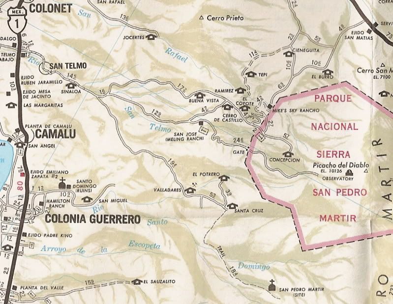
Here is a map with mileages along the route I took through Mike's Sky Rancho about ten years ago...

The larger area, on the Auto Club map of 1978 ('Concepcion' is Dark Skys Inn):
|
|
|
TMW
Select Nomad
Posts: 10659
Registered: 9-1-2003
Location: Bakersfield, CA
Member Is Offline
|
|
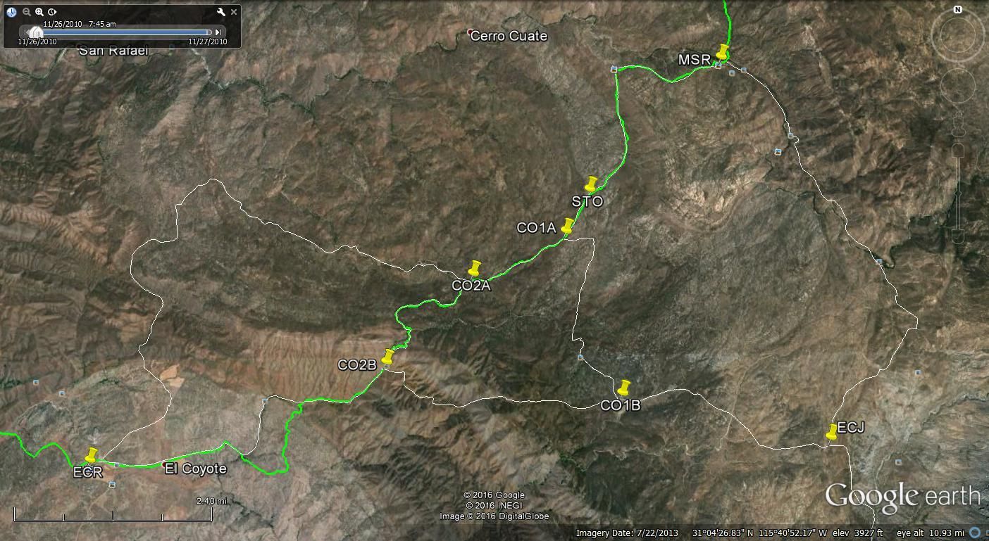
Here are the trails around Mike's from Google Earth. The green line is the 2013 Baja 1000 race course. Note in the lower left the green line bypasses
the white trail line because the road was washed out.
Lower right is where it goes to Mike and Pam's place and on to the Observatory Rd.
Larry where else is it washed out from the rains.
|
|
|
bajatrailrider
Ultra Nomad
Posts: 2553
Registered: 1-24-2015
Location: Mexico
Member Is Offline
Mood: Happy
|
|
Ok TMW first off,on Davids maps.They dont show new roads.It looks like from co2B to co2A.It was washed out year ago,but (If you had nerve) you could
get down it(To Coyote)then it got By pass,that's what got washed away again.It is very hard to place this with Google earth.Mike that lives at
Coyotes,will be back up there in few days.I can get his report to you.I know the old routes up there.Just wondering why Alfredo.Fixed only part of
road.My other friend Obel,has been up at Coyotes working tractor.I will see him in Town try to get more info.
|
|
|
bajatrailrider
Ultra Nomad
Posts: 2553
Registered: 1-24-2015
Location: Mexico
Member Is Offline
Mood: Happy
|
|
TMW can you show road better,to Mike and Pam.To see if shows new road bypass there locked gate.
|
|
|
geoffff
Senior Nomad
Posts: 721
Registered: 1-15-2009
Member Is Offline
|
|
Good info, thanks everyone. Looks like I won't try it with my van just yet.
-- Geoff
|
|
|
PaulW
Ultra Nomad
Posts: 3113
Registered: 5-21-2013
Member Is Offline
|
|
Last October 2 of the three roads were drive-able in your van. One easier that the other. Stand by and I will drive them and report back. Maybe next
week?
|
|
|
TMW
Select Nomad
Posts: 10659
Registered: 9-1-2003
Location: Bakersfield, CA
Member Is Offline
|
|
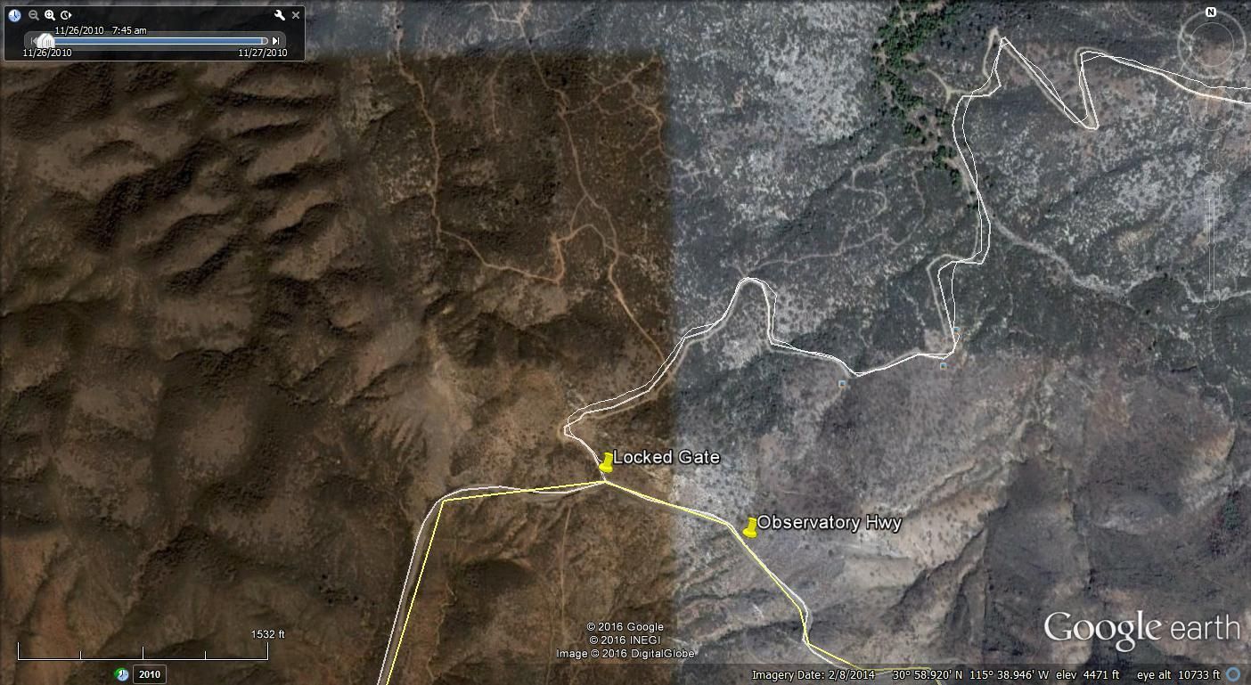
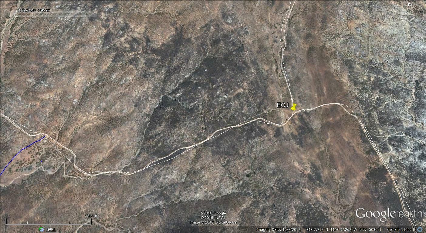
Here is a GE image of their locked gate at the Observatory Rd. I dont see any trails or road around it.
Here is a GE image with a trail from about half way between CO1B and ECJ. It is the blue line and it goes to a ranch north of the gate, but still
inside the gate.
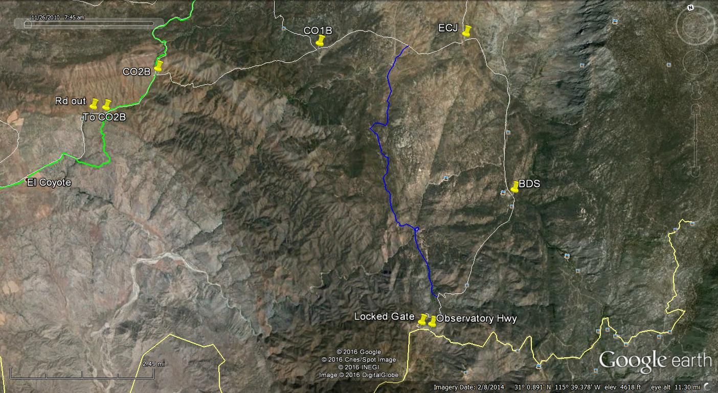
Here is a close up image of the turnoff at ECJ
This image is near El Coyote where SCORE did a bypass route. I followed the white line (regular road) about 3-4 years ago and where it shows Rd out
the road had about a 5-6 foot drop off on the north side but the south side was OK to drive up. A crew with shovels could probably fix it in no time.
About 30-40 feet before the drop off there is a steep embankment dropping down about 25 feet. At the bottom are large boulders and just enough space
for my Tacoma to turn with a few back and forths. At the time I took a chance and went down it because I saw car tracks up the other side and had
talked to a motorcycle guy at Mikes the night before. I dont know if I could have went up it because at the top is a tree and I would have had to
make a sharp 90 degree turn. I had to backup and go forward several times just to put my truck in position to go down.
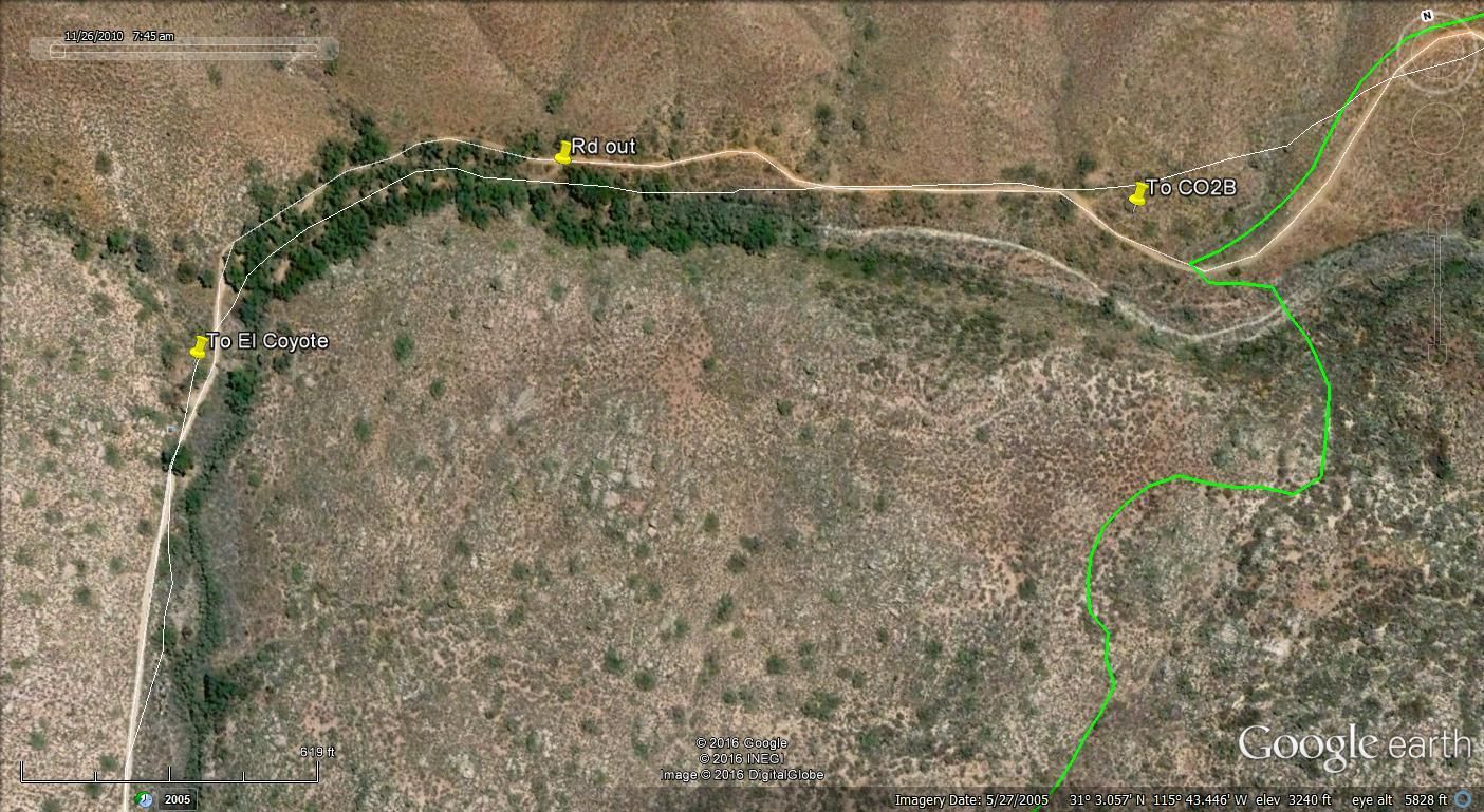
Mike and Pam's place is about half way between ECJ and the locked gate.
[Edited on 2-24-2016 by TMW]
|
|
|
David K
Honored Nomad
Posts: 65562
Registered: 8-30-2002
Location: San Diego County
Member Is Offline
Mood: Have Baja Fever
|
|
You are doing great Tom!
If the gate is locked at the observatory highway, they sure must not seek uninvited guests at their motel or B&B? When I posted it seemed they
closed up business, I got a bit of flak as if I didn't want them open. Quite the opposite, but just trying to be real not wishful.
|
|
|
bajatrailrider
Ultra Nomad
Posts: 2553
Registered: 1-24-2015
Location: Mexico
Member Is Offline
Mood: Happy
|
|
Ok Tom I don't see new road. The new road goes from Mikes to (Now I remember) Rancho La Joya. Could you pull up Rancho La Joya. It is west of Pam's
place. If you turned in from Observatory road. You go in few miles, then road to Rt goes to Pam's place. Slight to left Rancho La Joya. Then from
there rancho,you see new road they built. To go up it very hard. Much easier to go down from Mikes. I Think My Nissan 4x4 would make it down. There is
lots of brush,over growth. The turn real tight,I would think in LWB van. Be tuff. I have been up and down,New way. Many times on dirt bike, Even on
dirt bike.Its not for novice rider. Mike that lives at Coyote,said he will. Ride the routes and report back for us. Im reporting from last week.
|
|
|
geoffff
Senior Nomad
Posts: 721
Registered: 1-15-2009
Member Is Offline
|
|
| Quote: Originally posted by PaulW | | Last October 2 of the three roads were drive-able in your van. One easier that the other. Stand by and I will drive them and report back. Maybe next
week? |
That would be mighty kind of you to do some scouting  I'm actually planning on
passing through that area (or bypassing and just going over to Ensenada) in about a week from now, so it might be too late for me. I'm actually planning on
passing through that area (or bypassing and just going over to Ensenada) in about a week from now, so it might be too late for me.
I'm starting with Laguna Hanson and heading south, as I've never explored there either.
|
|
|
| Pages:
1
2
3 |


